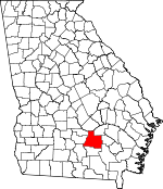
Coffee County, Georgia Basics:


Coffee County Georgia - Government Site

Population: 43,151
Area: 575 square miles
County seat: Douglas
Area code(s) in use: 912
Time zone: EST
High school graduate or higher: 73.8%
Bachelor's degree or higher: 11.3%
Median household income: $35,583
Persons in poverty: 24.2%
Home ownership rate: 68.3%
Mean travel time to work: 20.0 minutes


Adjacent counties:
Atkinson  Bacon  Ben Hill  Berrien  Irwin  Jeff Davis  Telfair  Ware  

Find in Georgia

Map of the Coffee County area


Our detail map of Coffee County shows the Coffee County, Georgia boundary lines and other interesting items.

Places in Coffee County, Georgia

  Airports     show all on map

Douglas Municipal Airport

  Buildings     show all on map

Ambrose Volunteer Fire Department, Baker Highway Volunteer Fire Station, Broxton Fire Department, Broxton Library, Broxton Police Department, Coffee Correctional Facility, Coffee County Courthouse, Coffee County Fire / Rescue Station 11 West Green, Coffee County Fire / Rescue Station 12 Nicholls, Coffee County Fire / Rescue Station 15 Chatterton, Coffee County Fire / Rescue Station 16 Wilsonville, Coffee County Fire / Rescue Station 6 Oak Park, Coffee County Fire / Rescue Station 8 Prigden, Coffee County Fire / Rescue Station 9 Green Acres, Coffee County Jail, Coffee County Sheriff's Department, Douglas City Hall, Douglas Fire Department Station 1, Douglas Fire Department Station 2, Douglas Fire Department Station 3, Douglas Police Department, Georgia State Patrol Troop H Post 36 Douglas, Nicholls Police Department, Satilla Regional Library, Sinkhole Volunteer Fire Department, South Georgia College Department of Public Safety, Walter R Wilson Agricultural Arena, William S Smith Library

  Cemeteries     show all on map

Ashley Yoemans Cemetery, Benjamin Chapel Cemetery, Bethany Cemetery, Bethel Cemetery, Broxton City Cemetery, Burkett Cemetery, Candacy Cato Cemetery, Carver Cemetery, Cato Cemetery, Central Cemetery, Chaney Cemetery, Chatterton Cemetery, Cole Cemetery, Daniel Cemetery, Davis Cemetery, Day Cemetery, De Berry Cemetery, Douglas City Cemetery, Forest Grove Cemetery, Franklin Cemetery, Frier Cemetery, Grantham Cemetery, Griffin Cemetery, Harper Cemetery, Harper Cemetery, Harper Cemetery, Harrell Grove Cemetery, Hebron Cemetery, Hinson Cemetery, Hollis Cemetery, John Carver Cemetery, Joseph Carver Cemetery, Kirkland Cemetery, Lax Cemetery, Lone Hill Cemetery, Lott Cemetery, Luke Cemetery, McClelland Cemetery, Meeks Cemetery, Meeks Cemetery, Moore Cemetery, Mora Cemetery, Morman Cemetery, Mount Union Cemetery, New Hope Cemetery, Nolan Cemetery, Oak Grove Cemetery, Oak Grove Cemetery, Old Wayfare Cemetery, Paulk Cemetery, Paulk Cemetery, Peterson Cemetery, Pine Forests Memorial Gardens, Prigden Cemetery, Purvis Cemetery, Reedy Branch Cemetery, Roberts Cemetery, Rocky Creek Cemetery, Rocky Pond Cemetery, Roxie Mae Cemetery, Saint Andrews Cemetery, Saint Illa Cemetery, Salem Cemetery, Sand Hill Cemetery, Smith Cemetery, Tanner Cemetery, Teston Cemetery, Union Cemetery, Vickers Cemetery, Ward Cemetery, Ward Cemetery, Wayfare Cemetery, Wilcox Cemetery, Wilcox Cemetery, Wood-Spell Cemetery, Young Cemetery

  Churches     show all on map

Bethany Church, Bethel Baptist Church, Broxton Baptist Church, Burkett Church, Bushnell Chapel, Bushnell Church, Calvary Church, Carver Church, Central Church, Chatterton Church, Christian Faith Outreach Ministry, Church of Christ, Church of God (historical), Church of God in Unity, Church of God of Prophecy, Church of the Holy God, Church of the Kingdom of God, Citizens Christian Academy, College Avenue Baptist Church, De Berry Church, Deliverance Center Church, Dry Creek Church, Elam Primitive Baptist Church, Everette Chapel Christian Methodist Episcopal Church, Fales Church, First Assembly of God Church, First Baptist Church, First Baptist Church, First Church of the Nazarene, First Congregational Christian Church, First Presbyterian Church, First United Methodist Church, Forest Grove Church, Franklin Church, Gaines Chapel Methodist Church (historical), Grace Baptist Church, Harrel Church, Harrel Grove Church, Harvest Time Church of God, Hebron Baptist Church, Hebron Church, Hills Chapel, Hispanic Baptist Mission, Holiness Church, Holiness Church (historical), House of Prayer Church, Jowers Chapel, Last Days True Holiness Mission, Lax Church, Little Geneva Church, Lone Hill Church, Macedonia Baptist Church (historical), Marys Chapel, Mora Baptist Church, Mount Calvary Church, Mount Ebell Church, Mount Union Church, New Beulah Church, New Hope Church, New Salem Church, New Zion Church, Northside Baptist Church, Oak Grove Church, Oak Grove Church, Oak Grove Church, Oak Park Church, Parkview Church, Pickerton Church, Pine Grove Church, Pine Street Church of God, Pineview Church, Prigden Baptist Church, Providence Church, Reedy Branch Church, Rocky Creek Church, Rocky Pond Church, Roxy Mae Church, Saginaw Baptist Church, Saint Andrews Episcopal Church, Saint Illias Church, Saint James Church, Saint John Baptist Church, Saint Mark United Methodist Church, Saint Pauls Roman Catholic Church, Saints Temple Church of God in Christ, Salem Holiness Baptist Church, Sand Hill Church, Seal Methodist Church (historical), Shady Grove Church, Shiloh Missionary Baptist Church, Sinai Pentecostal Holiness Church, Solomons Bridge Church, Sunnyside Church, Tanner Church, The Church of Jesus Christ of Latter Day Saints, Trinity Mission for Christ Deliverance Center, Union Church, Vickers Chapel, Wayfarer Church, West Green Baptist Church, West Green Church, West Green United Methodist Church, West Ward Street Church of God, Westside Holiness Church, Wilsonville Church

  Cliffs     show all on map

Barr Bluff

  Dams     show all on map

Bennie Dockery Pond Dam, Bush Lake Dam, C Paulk Lake Dam, Dockery Pond Dam, Harper Lake Dam, Haskin Lake Dam, Higgs Lake Dam, Hinson Lake Dam, Holiday Beach Dam, Holiday Beach Dam North, J J Dockery Pond Dam, James Smith Lake Dam, Johnson Lake Dam, Johnson Lake Dam North, Jowers Lake South Dam, Kight Lake Dam, Lott Lake Dam, Lott Lake Dam, Lott Lake Dam, Paulk Lake Dam, Paulk Lake Dam, Reynolds Lake Dam, Sam Jones Lake Dam, Smith Lake Dam

  Falls     show all on map

Rock Falls

  Hospitals     show all on map

Coffee Regional Medical Center

  Lakes     show all on map

Barr Lake, Hilliards Pond, Joyce Lake, Spar Lake

  Locales     show all on map

Beaver Creek Golf Course, Douglas Country Club, Flat Tub Landing, Gaskin Springs Camp, Northwest Industrial Park, Perimeter West Industrial Park, Southwest Industrial Park

  Parks     show all on map

Bell Lake Park, Eastside Park, Emma Wade Park, Faircloth Field, General Coffee State Park, Jardine Stadium, North Madison Park, Pine Street Park, Roundtree Center Park, Unity Park, Wade Field, Wheeler Park, Whispering Pines Park

  Populated Places     show all on map

Ambrose, Bay Meadows, Bethel, Blystonel, Bridgetown, Broxton, Bushnell, Chatterton, Cherokee Hills, Douglas, Huffer, Lehigh, Lotts, Mora, Nicholls, Oak Park, Pridgen, Relee, Saginaw, Sapps Still, Upton, West Green, Wilsonville

  Post Offices     show all on map

Ambrose Post Office, Douglas Post Office

  Reservoirs     show all on map

Bennie Dockery Pond, Bush Lake, C Paulk Lake, Cherokee Lake, Dockery Pond, Harper Lake, Haskin Lake, Higgs Lake, Hinson Lake, Holiday Beach Lake, Holiday Beach North Lake, J J Dockery Pond, James Smith Lake, Johnson Lake, Johnson Lake North, Kight Lake, Lott Lake, Lott Lake, Lott Lake, Paulk Lake, Paulk Lake, Reynolds Lake, Sam Jones Lake, Smith Lake

  Schools     show all on map

Ambrose Elementary School, Central School, Coffee County High School, Coffee Junior High School, Eastside School, George Washington Carver High School (historical), Hayes School, Mary Hayes High School, Nicholls Elementary School, Nicholls High School, Prigden School (historical), Rocky Pond School (historical), Saint Illa School (historical), Salem School (historical), Satilla School, South Georgia College, Sunny Side School (historical), Vickers Chapel School (historical), West Green Elementary School, Westside School

  Streams     show all on map

Aunt Omie Creek, Bear Creek, Bear Creek, Bee Gum Branch, Big Branch, Broxton Creek, Cat Creek, Dry Creek, Forky Creek, Halls Creek, Hurricane Creek, Indian Creek, Little Creek, Little Hog Creek, Mill Creek, Mobley Bluff Creek, Ninemile Creek, Otter Creek, Paul Creek, Reedy Branch, Reedy Creek, Rocky Creek, Roses Creek, Saint Marys River, Satilla Creek, Seven Creek, Smut Branch, Stafford Branch, Tiger Creek, Turkey Branch, Twenty Mile Creek, Twentynine Mile Creek, Wiggins Creek

  Summits     show all on map

Rose Hill

  Towers     show all on map

WDMG-AM (Douglas), WDMG-AM (Douglas), WDMG-FM (Douglas), WDMG-FM (Douglas), WOKA-AM (Douglas), WOKA-FM (Douglas),

Coffee County, Georgia Population By Race (2012 estimate)

RacePopulation
WhiteCoffee County White population 30,11930,119  
BlackCoffee County Black population 11,99611,995
MixedCoffee County Mixed population 475474
AsianCoffee County Asian population 345345
American IndianCoffee County American Indian population 173172
Hawaiian & Pacific IslanderCoffee County Hawaiian & Pacific Islander population 4343

Additional population tables :
State population table
Georgia population by county