Atkinson County, Georgia Basics:


Atkinson County Georgia - Government Site

Population: 8,257
Area: 339 square miles
County seat: Pearson
Area code(s) in use: 912
Time zone: EST
High school graduate or higher: 64.5%
Bachelor's degree or higher: 8.7%
Median household income: $28,682
Persons in poverty: 34.1%
Home ownership rate: 68.0%
Mean travel time to work: 20.2 minutes

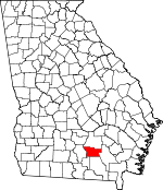
Adjacent counties:
Berrien  Clinch  Coffee  Lanier  Ware  

Find in Georgia

Map of the Atkinson County area


Our detail map of Atkinson County shows the Atkinson County, Georgia boundary lines and other interesting items.

Places in Atkinson County, Georgia

  Buildings     show all on map

Atkinson County Courthouse, Atkinson County Jail, Atkinson County Sheriff's Office, Axson Volunteer Fire Department, Pearson Police Department, Pearson Volunteer Fire Department, Willacoochee Fire Department, Willacoochee Police Department

  Cemeteries     show all on map

Death Age Cemetery, Kight Cemetery, Tison Cemetery, Utah Cemetery, White Cemetery

  Churches     show all on map

Allen Chapel, Antioch Church, Arnie Primitive Baptist Church, Axson Church, Bethel Church, Beulah Church, Crossroads Church, First Born Church, Harmony Grove Church, Holy Family Chapel, Kirkland Church, Live Oak Church, Mount Pleasant Church, Mount Zion Church, Mount Zion Church, Ozias Church, Red Bluff Church, Refuge Church, Saint Johns Church, Salem Church, Spring Head Church, Stokesville Church, Sunnyside Church, Sweetwater Church, Taylors Chapel, Union Hill Church, Utah Church, Wesley Chapel

  Cliffs     show all on map

Parkers Bluff

  Dams     show all on map

Metz Lake Dam, Vickers Lake Dam

  Islands     show all on map

Double Islands

  Lakes     show all on map

Butchers Pond, Guest Millpond, Half Moon Lake, Hastings Fish Pond, Kirkland Millpond, Long Bay, Round Lake, Smith Pond, Stewart Lake

  Populated Places     show all on map

Axson, Gracys Station (historical), Henderson Still, Kirkland, Leliaton, Oberry, Pearson, Sandy Bottom, Stokesville, Willacoochee

  Post Offices     show all on map

Axson Post Office, Kirkland Post Office (historical), Pearson Post Office, Pinebloom Post Office (historical), Willacoochee Post Office

  Reservoirs     show all on map

Metz Lake, Vickers Lake

  Schools     show all on map

Atkinson County Junior High School, Pearson Elementary School, Willacoochee Elementary School

  Streams     show all on map

Big Branch, Braswell Creek, Dark Bay, Dry Branch, Hog Creek, Little Red Bluff Creek, Mill Creek, Pole Branch, Pudding Creek, Red Bluff Creek, Reedy Creek, Ruffin Creek, Stump Creek, Sweetwater Creek, Willacoochee River

  Swamps     show all on map

Camp Bay, Featherbed Bay, Head of the Creek, Hog Creek Bay, Meeting House Bay, Old Ninety Bay, Pee Dee Bay, Ricketson Bay, Roundabout Swamp, Still Bay, Wolf Bay

  Towers     show all on map

WWFP-FM (Pearson),

Atkinson County, Georgia Population By Race (2012 estimate)

RacePopulation
WhiteAtkinson County White population 6,4166,415  
BlackAtkinson County Black population 1,4531,453
MixedAtkinson County Mixed population 149148
American IndianAtkinson County American Indian population 107107
Hawaiian & Pacific IslanderAtkinson County Hawaiian & Pacific Islander population 8382
AsianAtkinson County Asian population 5049

Additional population tables :
State population table
Georgia population by county