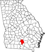
Berrien County, Georgia Basics:


Berrien County Georgia - Government Site

Population: 19,077
Area: 452 square miles
County seat: Nashville
Area code(s) in use: 229
Time zone: EST
High school graduate or higher: 75.9%
Bachelor's degree or higher: 11.8%
Median household income: $31,506
Persons in poverty: 24.7%
Home ownership rate: 71.4%
Mean travel time to work: 25.1 minutes


Adjacent counties:
Atkinson  Coffee  Cook  Irwin  Lanier  Lowndes  Tift  

Find in Georgia

Map of the Berrien County area


Our detail map of Berrien County shows the Berrien County, Georgia boundary lines and other interesting items.

Places in Berrien County, Georgia

  Airports     show all on map

Berrien County Airport, South One Ten Airport

  Bridges     show all on map

Long Bridge

  Buildings     show all on map

Alapaha Police Department, Alapaha Volunteer Fire Department, Berrien County Courthouse, Berrien County Jail, Berrien County Sheriff's Office, Berrien Nursing Center, Carrie Dorsey Perry Memorial Library, East Berrien Fire Department, Enigma Police Department, Enigma Volunteer Fire Department, Nashville City Hall, Nashville Fire Department, Nashville Police Department, New Lois Volunteer Fire Department, Ray City Police Department, Ray City Volunteer Fire Department, West Berrien Volunteer Fire Department

  Cemeteries     show all on map

Avera Cemetery, Baskins Cemetery, Bennett Cemetery, Connell Cemetery, Eastview Cemetery, Flat Creek Cemetery, Fletcher Cemetery, Gaskins Cemetery, Gaskins Cemetery, Gaskins Graveyard, Golpher Hill Cemetery, Griner Cemetery, Hendley Cemetery, Inigma Cemetery, Luke Cemetery, Mount Paron Cemetery, Oaky Grove Cemetery, Old Griner Cemetery, Old Nashville Cemetery, Pleasant Cemetery, Poplar Springs Cemetery, Ray City Cemetery, Saint James Cemetery, Sandy Bluff Cemetery, Tygart Cemetery, Vickers Cemetery, West View Cemetery

  Churches     show all on map

Baker Chapel, Barnes Church, Bethel Church, Bristol Temple, Call to Faith Tabernacle, Christian Church of God, Church of God, Church of God, Community Church, Community Church, Ebenezer Church, Emmaus Primitive Baptist Church (historical), First Baptist Church of Nashville, First Baptist Church of Ray City, Flat Creek Church, Forrester Church, Full Gospel Chapel, Glory Church, Grahams Chapel, Guthrie Church, Holiness Church, Holiness Church, Immanuel Baptist Church, Immanuel Church, Jesus Name Church, Liberty Church, Long Bridge Church, Mathis Chapel Holiness Baptist Church, Mount Paran Church, Mount Pleasant Church, Nashville Church of Christ, Nashville Church of the Nazarene, Nashville Holiness Deliverance Church, Nashville Mission, Nashville Primitive Baptist Church, Nashville United Methodist Church, New Bethel Baptist Church, New Griffin Church, New Ramey Church, New River Church, Oak Grove Church, Parkers Chapel, Pine Grove Church, Pine Ridge Church, Pleasant Church, Pleasant Hill Church, Poplar Springs Church, Riverside Church, Rowe Town Church, Saint James Methodist Church, Saint Lukes Church, Saint Marys Catholic Church, Temple Church, Trinity Church, Trinity Methodist Episcopal Church (historical), United Pentecostal Church, Vickers Church, Zion Wall Freewall Baptist Church

  Dams     show all on map

Gaskins Lake Dam, Gaskins Lake Dam, Hand Lake Dam, Hardy Millpond Dam, Horseshoe Five Lake Dam, Horseshoe Four Lake Dam, Lake Bobben Dam, Lake Patrick Dam, Lake Russell Dam, Lindsey Lake Dam, Martin Lake Dam, McMillian Lake Dam, McMillian Lake Dam, Rays Mill Pond Dam, Sapps Lake Dam, Tucker Lake Dam

  Hospitals     show all on map

Askew Memorial Hospital (historical), Berrien County Hospital

  Lakes     show all on map

Averys Millpond, District Pond, Gaskins Pond, Gin Pond, Griner Pond, Horseshoe 4, Horseshoe 5, Lake Bobben, Lake Patrick, Lake Russel, McMillan Lake, Purvis Lake

  Locales     show all on map

Alapaha Experimental Range, Avera Mill (historical), Berrien County Farm, Camp Tygart, Flat Creek Mills (historical), Georgia Coastal Plain Experimental Station, Rays Mill (historical)

  Parks     show all on map

Beetree Recreation Area, Carter Park, Dogwood Street Recreation Area, Heritage Park, Northside Park, Tygart Park

  Populated Places     show all on map

Alapaha, Allenville, Bannockburn, Cottle, Enigma, Gladys, Glory, Nashville, New Lois, Ray City, Weber

  Post Offices     show all on map

Nashville Post Office, Weston Mills Post Office (historical)

  Reservoirs     show all on map

Gaskins Lake, Gaskins Lake, Hand Lake, Hardy Millpond, Horsehsoe S Lake, Horseshoe A Lake, Lake Bobben, Lake Patrick, Lake Russell, Lindsey Lake, Martin Lake, McMillian Lake, McMillian Lake, Rays Mill Pond, Sapps Lake, Tucker Lake

  Schools     show all on map

Alapaha Elementary School, Berrien County High School, Nashville Elementary School, Nashville Middle School, Nashville Vocational School (historical), New River School (historical), Vickers School (historical), West Berrien School

  Streams     show all on map

Batterbee Branch, Beaverdam Creek, Big Branch, Camp Branch, Cypress Creek, District Branch, Flat Creek, Futch Branch, Gin Branch, Gum Branch, Gum Creek, Hardy Mill Creek, Hog Creek, Poley Branch, Possum Creek, Reedy Branch, Reedy Creek, Simon Branch, Wolf Branch, Wolfpen Branch

  Swamps     show all on map

Bennett Pond, Butler Pond, Morris Pond, Phoeba Bay, Slash Pond, Tenmile Bay, Tiger Bay

  Towers     show all on map

WHFE-FM (Lakeland), WHFE-FM (Lakeland), WNGA-AM (Nashville),

Berrien County, Georgia Population By Race (2012 estimate)

RacePopulation
WhiteBerrien County White population 16,52116,520  
BlackBerrien County Black population 2,1372,136
MixedBerrien County Mixed population 229228
AsianBerrien County Asian population 114114
American IndianBerrien County American Indian population 7676
Hawaiian & Pacific IslanderBerrien County Hawaiian & Pacific Islander population 00

Additional population tables :
State population table
Georgia population by county