Cook County, Georgia Basics:


Cook County Georgia - Government Site

Population: 16,909
Area: 227 square miles
County seat: Adel
Area code(s) in use: 229
Time zone: EST
High school graduate or higher: 74.3%
Bachelor's degree or higher: 11.9%
Median household income: $35,983
Persons in poverty: 22.7%
Home ownership rate: 70.7%
Mean travel time to work: 23.1 minutes

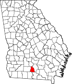
Adjacent counties:
Berrien  Brooks  Colquitt  Lowndes  Tift  

Find in Georgia

Map of the Cook County area


Our detail map of Cook County shows the Cook County, Georgia boundary lines and other interesting items.

Places in Cook County, Georgia

  Airports     show all on map

Cook County Airport

  Bridges     show all on map

Brown Bridge, Buckholts Bridge, Burney Bridge, Connell Bridge, Futchs Bridge, Gainey Bridge, Hesters Bridge, Kinard Bridge, Lotts Bridge, McConnell Bridge (historical), Rock Bridge (historical), Rountree Bridge, Whitehurst Bridge, Williams Bridge

  Buildings     show all on map

Adel City Hall, Adel Fire Department Station 1, Adel Fire Department Station 2, Adel Police Department, Cecil Volunteer Fire Department, Chaserville - Massee Volunteer Fire Department, Cook County Courthouse, Cook County Jail, Cook County Library, Cook County Sheriff's Office, Lenox Police Department, Lenox Volunteer Fire Department, Pine Valley Fire Department, Sparks Police Department, Sparks Volunteer Fire Department

  Cemeteries     show all on map

Antioch Cemetery, Baker Cemetery, Daniels Cemetery, Jerusalem Cemetery, Mathis Cemetery, Money Cemetery, Salem Cemetery, Sylvester Cemetery, Wilkes Cemetery, Woodlawn Memorial Gardens

  Churches     show all on map

Adel Assembly of God Church, Adel Church of God, Adel Methodist Church, Adel Presbyterian Church, Adel Primitive Baptist Church, Antioch Church, Bethel Missionary Baptist Church, Bethlehem Primitive Baptist Church, Beulah Church, Brushy Creek Church, Cecil Baptist Church, Community Church, Concord Primitive Baptist Church, County Line Church, Cross Roads Wesleyan Methodist Church, Evergreen Church, Fellowship Church, First Baptist Church, First Church of the Nazarene, Forest Hill Church, Full Gospel Church, Greggs Baptist Church, Jerusalem Missionary Church, Lakeview Church, Macedonia Church, Massee Baptist Church, New Hope Church, Rose Hill Church, Saint Pauls Church, Salem Primitive Baptist Church, Shady Grove Church, Sparks Baptist Church, Spring Hill Church, Springhead Church, West Central Avenue Church of God, West Side Baptist Church

  Crossings     show all on map

Exit 10, Exit 11, Exit 12, Exit 13, Exit 8, Exit 9

  Dams     show all on map

Betts Lake Dam, Boyette Pond Dam, City of Adel Lake Dam, Griffin Lake Dam, Grist Lake Dam, Parrish Pond Dam, Pervis Lake Dam, Saunders Lake Dam, Sumner Lake Dam, Whitehurst Pond Dam

  Hospitals     show all on map

Memorial Hospital of Adel

  Lakes     show all on map

Big Pond, Cecil Bay, Daniels Pond, Goose Pond, Halls Pond, Heart Pine Pond, Hutchinson Pond, No Mans Friend Pond

  Locales     show all on map

Carters Still (historical)

  Populated Places     show all on map

Adel, Barnesdale, Barneyville, Berrien (historical), Burney Hill, Cecil, Chaserville, Fellowship, Flat Ford, Greggs, Heartpine (historical), Jerusalem (historical), Laconte, Lenox, Massee, Nola (historical), Pine Valley, Sparks, Staunton, Wagon Wheel

  Post Offices     show all on map

Adel Post Office

  Reservoirs     show all on map

Betts Lake, Boyette Pond, City of Adel Lake, Futchs Pond, Griffin Lake, Grist Lake, Hancock Pond, Parrish Pond, Pervis Lake, Saunders Lake, Sumner Lake, Whitehurst Pond

  Schools     show all on map

Adel Elementary School, Adel Institute (historical), Alpha School (historical), Brushy Creek School (historical), Cook High School, Cook Middle School, Grovania School (historical), Lenox Elementary School, Lone Star School (historical), Midway School (historical), Sparks Academy (historical), Sparks Collegiate Institute (historical), Sparks Elementary School, Spring Hill School (historical), Stonewall Academy (historical)

  Streams     show all on map

Bear Creek, Big Branch, Brushy Creek, Doe Branch, Flat Branch, Giddens Mill Creek, Hutchinson Mill Creek, Indian Trail Branch, Lindsey Branch, Moccasin Slough, Morrison Creek, New River, Pikes Creek, Poley Branch, Rock Branch, Rosin Dam Branch, Wells Mill Creek, Youngs Mill Creek

  Swamps     show all on map

Crossroads Bay, Giddens Pond, Thornhill Bay

  Towers     show all on map

WBIT-AM (Adel), WDDQ-FM (Adel), WJYF-FM (Nashville), WVGA-TV (Valdosta),

Cook County, Georgia Population By Race (2012 estimate)

RacePopulation
WhiteCook County White population 11,85311,853  
BlackCook County Black population 4,6674,666
MixedCook County Mixed population 186185
AsianCook County Asian population 135135
American IndianCook County American Indian population 6867
Hawaiian & Pacific IslanderCook County Hawaiian & Pacific Islander population 00

Additional population tables :
State population table
Georgia population by county