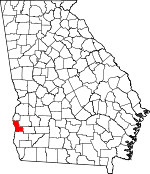
Clay County, Georgia Basics:


Clay County Georgia - Government Site

Population: 3,106
Area: 195 square miles
County seat: Fort Gaines
Area code(s) in use: 229
Time zone: EST
High school graduate or higher: 75.8%
Bachelor's degree or higher: 9.2%
Median household income: $22,582
Persons in poverty: 47.7%
Home ownership rate: 67.9%
Mean travel time to work: 24.3 minutes


Adjacent counties:
Barbour (AL)  Calhoun  Early  Henry (AL)  Quitman  Randolph  

Find in Georgia

Map of the Clay County area


Our detail map of Clay County shows the Clay County, Georgia boundary lines and other interesting items.

Places in Clay County, Georgia

  Airports     show all on map

Coates Airport

  Bridges     show all on map

Henry Clay Bridge (historical), Henry G McKemie Bridge, Killen Bridge

  Buildings     show all on map

Clay County Courthouse, Clay County Sheriff's Department, Clay County Volunteer Fire Department, Clay County Volunteer Fire Department Station 2, Clay County Volunteer Fire Department Station 3, Fort Gaines Police Department

  Cemeteries     show all on map

Bethel Cemetery, Bluffton Cemetery, Bryant-Neves Cemetery, Campground Cemetery, Enterprise Cemetery, Fort Gaines Cemetery, Judson Cemetery, Midway Cemetery, Mount Gilead Cemetery, Mount Vernon Cemetery, Mount Zion Cemetery, New Bethel Cemetery, New Lowell Cemetery, New Park Cemetery, Pecan Cemetery, Rose Hill Cemetery, Saint James Cemetery, Shiloh Cemetery, Singletary Cemetery, Vincent Cemetery, Wesley Cemetery

  Churches     show all on map

Aimwell Church, Antioch Church, Beauchamp Chapel, Bethel Church, Bethel Church, Bluffton Baptist Church, Bluffton Methodist Church, Cannon Grove Church, Ebenezer Church, Emanuel Church, Enon Church, Enterprise Church, Fort Gaines Baptist Church, Fort Gaines Presbyterian Church, Fort Gaines United Methodist Church, Friendship Church, Green Chapel, Macedonia Church, Midway Baptist Church (historical), Mitchel Grove Church, Mount Calvary Church, Mount Gilead Church, Mount Vernon Church, Mount Zion Church, Mount Zion Church, Mount Zion Church, New Bethel Church, New Hope Church, New Judson Church, New Lowell Church, Old Camp Ground Church (historical), Piney Grove Church, Saint Lukes Church, Saint Peters Church, Shiloh Church, Springfield Missionary Baptist Church, Thompson Grove Church, Union Church, Vincent Church, Wesley Chapel

  Dams     show all on map

Deloach Lake Dam, Faines Lake Dam, Fendley Lake Dam, Fendley Lake Dam, Hattaway Lake Dam, Mckemie Lake Dam, Mckemie Lake North Dam, Walter F George Lock and Dam

  Lakes     show all on map

Hartley Pond, Ocean Pond

  Locales     show all on map

Credille Mill (historical), Standleys Store

  Military     show all on map

Fort Gaines (historical)

  Parks     show all on map

Cotton Hill Public Use Area, East Bank Public Use Area, Fort Gaines Historic District, George T Bagby State Park, Pataula Creek Public Use Area, Sandy Branch Public Use Area, Sandy Creek Public Use Area

  Populated Places     show all on map

Bellville, Bethel, Bluffton, Cotton Hill, Days Crossroads, Fort Gaines, Garnersville, Harrisons Mill, Jeff, Jones Crossing, Moores Crossroads, Oakland, Oketeyeconne (historical), Pecan, Ricks Place, Suttons Corner, Watson Crossroads, Zetto

  Reservoirs     show all on map

DeLoach Lake, Faines Lake, Fendley Lake, Fendley Lake, Hattaway Lake, Mckemie Lake, Mckenie Lake North

  Schools     show all on map

Bluffton High School (historical), Clay County High School, Cotton Hill Seminary (historical), County School Number 2, Fairview School (historical), Fort Gaines Academy (historical), Fort Gaines Female College (historical), Oakland School (historical), Speight High School

  Streams     show all on map

Cemochechobee Creek, Drag Nasty Creek, Engram Branch, Fendley Branch, Flat Creek, Gates Branch, Huckleberry Branch, Kolomoki Creek, Ledbetter Branch, Little Creek, North Prong Kolomoki Creek, Pataula Creek, Roaring Branch, Sandy Branch, Sandy Creek, Town Branch, Waukeefriskee Creek, Wilkey Creek, Williams Creek

  Summits     show all on map

Johnny Moore Hill

  Swamps     show all on map

Cypress Pond

  Towers     show all on map

Clay Lookout Tower, Perkins Lookout Tower,

Clay County, Georgia Population By Race (2012 estimate)

RacePopulation
BlackClay County Black population 1,8511,851  
WhiteClay County White population 1,2021,202
MixedClay County Mixed population 2827
American IndianClay County American Indian population 1212
Hawaiian & Pacific IslanderClay County Hawaiian & Pacific Islander population 33

Additional population tables :
State population table
Georgia population by county