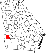
Randolph County, Georgia Basics:


Randolph County Georgia - Government Site

Population: 7,311
Area: 428 square miles
County seat: Cuthbert
Area code(s) in use: 229
Time zone: EST
High school graduate or higher: 74.7%
Bachelor's degree or higher: 14.4%
Median household income: $32,688
Persons in poverty: 25.3%
Home ownership rate: 73.2%
Mean travel time to work: 18.5 minutes


Adjacent counties:
Calhoun  Clay  Quitman  Stewart  Terrell  Webster  

Find in Georgia

Map of the Randolph County area


Our detail map of Randolph County shows the Randolph County, Georgia boundary lines and other interesting items.

Places in Randolph County, Georgia

  Airports     show all on map

Andrews Airport, Bynum Airport, Grubbs Airport, Lower Chattahoochee Regional Airport, Sammons Airport

  Bridges     show all on map

Fountain Bridge

  Buildings     show all on map

Cuthbert Fire Department, Cuthbert Police Department, Georgia State Patrol Troop G Post 39 Cuthbert, Pitts Library, Randolph County Courthouse, Randolph County Emergency Management Fire and Rescue, Randolph County Fire Department Benevolence Station, Randolph County Fire Department Carnegie Station, Randolph County Fire Department Coleman Station, Randolph County Fire Department Springvale Station, Randolph County Jail, Randolph County Library, Randolph County Sheriff's Office, Shellman Police Department, Shellman Volunteer Fire Department

  Capes     show all on map

Sugar Hill

  Cemeteries     show all on map

Benevolence Baptist Church Cemetery, Bethelem Freewill Baptist Church Cemetery, Carnegie Baptist Church Cemetery, Damascus Baptist Church Cemetery, Eastview Cemetery, Ebenezer Cemetery, Ebenezer Cemetery, Friendship Baptist Church Cemetery, Greenwood Cemetery, Henderson Powell Cemetery, Margus Cemetery, Mitchell Grove Baptist Church Cemetery, Mount Gilead Cemetery, Mount Hebron Church Cemetery, Mount Vernon Baptist Church Cemetery, New Bethel Baptist Church Cemetery, New Hope Cemetery, Pleasant Grove Church Cemetery, Pleasant Hill Baptist Church Cemetery, Rehoboth Church Cemetery, Springvale Cemetery, Vilulah Cemetery

  Census     show all on map

Coleman Census Designated Place

  Churches     show all on map

Antioch Baptist Church, Benevolence Baptist Church, Bethel Church, Bethlehem Church, Beulah Church (historical), Carnegie Baptist Church, Cuthbert Presbyterian Church, Cuthbert United Methodist Church, Damascus Church, Ebenezer Church (historical), Enterprise Church, Faith Baptist Church, First Baptist Church, First Baptist Church of Cuthbert, Friendship Baptist Church, Friendship Church, Hopewell Church, Mitchell Grove Church, Mount Airy Church, Mount Calvary Church, Mount Gilead Church, Mount Hebron Church, Mount Olive Church (historical), Mount Vernon Church, Mount Zion Church, Mount Zion Church (historical), New Beginning Holiness Church, New Bethel Church, New Hope Baptist Church (historical), Oak Grove Church, Old Bethel Church (historical), Pachitla Church, Piney Grove Church, Pleasant Grove Church, Pleasant Grove Church (historical), Pleasant Hill Church, Prospect Church, Pumpkin Town Church, Rehobeth Church, Rocky Bottom Church, Saint Lukes Church, Saint Marys Church (historical), Salem Baptist Church, Sharon Church, Shorter Chapel, Springvale Baptist Church, Springvale Methodist Church, Sweet Home Church (historical), Trinity Church, Union Grove Church, Union Hill Church, Vilulah Church, Vilulah Church, Virgil Chapel, Zion Rock Church

  Dams     show all on map

Bentley Lake Dam, Bridges Lake Dam, Bullock Lake Dam, Bynum Lake Dam, Cloud Lake Dam, Coffin Lake Dam, Curry Lake Dam, English Lake Dam, Faircloth Lake Dam, Flint River Girl Scout Lake Dam, Grinols Lake Dam, Jackson Lake Dam, Lake Marie Dam, Lies Lake Dam, Maddox Lake Dam, McDonald Lake Dam, Merritt Lake Dam, Merritt Lake Dam, Phillips Pond Dam, Rice Lake Dam, Rice Lake Dam North, Shellhouse Lake Dam, Wall Lake Dam, Wheely Lake Dam, Williams Lake Dam, Wohlender Lake Dam

  Hospitals     show all on map

Southwest Georgia Regional Medical Center

  Lakes     show all on map

Hundred Acre Pond, Pearces Pond

  Locales     show all on map

Barges Mill (historical), Bells Mill (historical), Binions Mill (historical), Bones Mill (historical), Butlers Mill (historical), Camp Okitayakani, Central Junction, Crittenden Mill (historical), Millers Mill (historical), Millirons Mill (historical), Pitman Mill (historical), Randolph Country Club, Seelys Mill, Springvale Station, Wards Mill (historical), Weatherbys Mill (historical), White House

  Parks     show all on map

Cuthbert Historic District, Shellman Historic District

  Populated Places     show all on map

Aycock Mill, Bass Store, Benevolence, Blackburns Store (historical), Brooksville, Carnegie, Coleman, Coles, Cuthbert, Five Points, Goffs Mill, Gore, Grubb (historical), Martins Crossroads, Pachitla, Peterson Hill, Pumpkintown, Shellman, Shivers Mill, Springvale, Wades, Water Pipe

  Post Offices     show all on map

Cuthbert Post Office

  Reservoirs     show all on map

Bentley Lake, Bridges Lake, Bullock Lake, Butlers Pond, Bynum Lake, Cloud Lake, Coffin Lake, Curry Lake, English Lake, Faircloth Lake, Flint River Girl Scout Lake, Grinols Lake, Jackson Lake, Lake Marie, Lies Lake, Maddox Lake, Marie Lake, McDonald Lake, Merritt Lake, Merritt Lake, Phillips Pond, Phillps Pond, Rice Lake, Rice Lake North, Shellhouse Lake, Wall Lake, Wheely Lake, Williams Lake, Wohlender Lake

  Schools     show all on map

Andrew College, Mobley School (historical), Randolph Academy (historical), Randolph Elementary School, Randolph Middle School, Randolph Southern School, Randolph-Clay High School, Rehobeth Academy (historical), Saint Lukes School (historical), Springvale Institute (historical), Terrell School (historical), Tigner School (historical)

  Streams     show all on map

Bear Branch, Caney Branch, Collins Mill Creek, Cottonhouse Branch, Crooked Creek, Deer Creek, Fellows Branch, Goffs Mill Creek, Gormley Branch, Hog Creek, Hog Creek, Hunt Branch, Jordan Branch, Kitchen Branch, Knowles Branch, Little Ichawaynochaway Creek, Little Pumpkin Creek, Long Branch, Long Branch, McCallop Creek, Meal Creek, Mill Branch, Mill Branch, Mossy Branch, Muddy Branch, Owon Branch, Panther Branch, Parker Branch, Pittmans Mill Branch, Pool Branch, Pumpkin Creek, Rhodes Branch, Shivers Mill Creek, Soapstone Branch, Tabor Branch, Taylor Branch, Taylor Branch, Town Branch, Ward Branch, West Fork Ichawaynochaway Creek, Wolf Branch, Yankee Branch

  Towers     show all on map

WCUG-AM (Cuthbert), WDRL-FM (Cuthbert),

Randolph County, Georgia Population By Race (2012 estimate)

RacePopulation
BlackRandolph County Black population 4,4094,408  
WhiteRandolph County White population 2,8072,807
MixedRandolph County Mixed population 5151
AsianRandolph County Asian population 2929
Hawaiian & Pacific IslanderRandolph County Hawaiian & Pacific Islander population 77

Additional population tables :
State population table
Georgia population by county