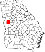
Meriwether County, Georgia Basics:


Meriwether County Georgia - Government Site

Population: 21,318
Area: 501 square miles
County seat: Greenville
Area code(s) in use: 706 770
Time zone: EST
High school graduate or higher: 71.7%
Bachelor's degree or higher: 9.8%
Median household income: $37,660
Persons in poverty: 17.3%
Home ownership rate: 71.8%
Mean travel time to work: 29.9 minutes


Adjacent counties:
Coweta  Harris  Pike  Spalding  Talbot  Troup  Upson  

Find in Georgia

Map of the Meriwether County area


Our detail map of Meriwether County shows the Meriwether County, Georgia boundary lines and other interesting items.

Places in Meriwether County, Georgia

  Airports     show all on map

E H Hutton Airstrip, Fagundes Field Airport, Flying N Estates Airport, M K Field Airport, Roosevelt Memorial Airport

  Areas     show all on map

The View

  Basins     show all on map

The Cove

  Bridges     show all on map

Burdette Bridge, Double Bridges, Halls Bridge (historical), Iron Bridge, Powell Bridge (historical), Red Oak Creek Covered Bridge, Riggins Bridge (historical), Sullivans Bridge (historical), White Oak Creek Covered Bridge

  Buildings     show all on map

Georgia State Patrol Troop D Post 34 Manchester, Greenville Police Department, Luthersville Fire Department, Luthersville Police Department, Manchester Fire Department, Manchester Police Department, Meriwether County Courthouse, Meriwether County Emergency Medical Services, Meriwether County Jail, Meriwether County Sheriff's Office, Meriwether County Volunteer Fire Department Station 1 Headquarters, Meriwether County Volunteer Fire Department Station 10, Meriwether County Volunteer Fire Department Station 11, Meriwether County Volunteer Fire Department Station 3, Meriwether County Volunteer Fire Department Station 4, Meriwether County Volunteer Fire Department Station 5, Meriwether County Volunteer Fire Department Station 6, Meriwether County Volunteer Fire Department Station 7, Meriwether County Volunteer Fire Department Station 8, Meriwether County Volunteer Fire Department Station 9, Pine Mountain Regional Library, The Little White House, Warm Springs Fire Department, Warm Springs Foundation, Warm Springs Police Department, Woodbury Police Department, Woodbury Volunteer Fire Department Station 13

  Cemeteries     show all on map

Alford Cemetery, Barnes Cemetery, Barron Cemetery, BaughanStrozier Cemetery, Bethel Cemetery, Bethesda Cemetery, Blount Cemetery, Blount Peavy Cemetery, Bowman Cemetery, Branch Hebron Cemetery, Braswell Cemetery, Brooks Cemetery, Caldwell-Williams Cemetery, Campground Cemetery, Clemens Cemetery, Cole Cemetery, Concord Cemetery, Connally Cemetery, Coplan-Perry Cemetery, County Line Cemetery, Cousins Cemetery, Crouch Cemetery, Crowley Cemetery, Dunlap Cemetery, Ebenezer Cemetery, Fellowship Cemetery, Florence Cemetery, Gilbert Cemetery, Greenville Church Cemetery, Greer and Robertson Cemetery, Grier Cemetery, Hannah Cemetery, Harris Cemetery, Head Cemetery, Jones Cemetery, Judson-Bulloch Cemetery, Keith Cemetery, Manchester Cemetery, Mann Cemetery, Marchman Cemetery, Martin Cemetery, Mathews Cemetery, McKee Cemetery, McLaughin Cemetery, Milam Cemetery, Mount Pilgrim Cemetery, Mount Pleasant Cemetery, Needmore Cemetery, Ogletree Cemetery, Ogletree Cemetery, Ollie Branch Cemetery, Owens Cemetery, Possum Trot Cemetery, Prospect Cemetery, Providence Cemetery, Red Oak Cemetery, Saint Pauls Cemetery, See Cemetery, Sharp Cemetery, Spring Chapel Cemetery, Strickland Town Cemetery, Thrash Cemetery, Thrash Cemetery, Tigner Cemetery, Tucker Cemetery, Turner Cemetery, Union Cemetery, Waddell Cemetery, Ward Cemetery, Ware Cemetery, West Brown Cemetery, White Oak Cemetery, Woods Cemetery, Woodward Cemetery

  Churches     show all on map

Allen-Lee Memorial Church, Antioch Baptist Church, Arbor Chapel, Bethel Church, Bethel Church, Bethesda United Methodist Church, Bethlehem Church, Bethlehem Church, Bowes Chapel, Branch Hebron Church, Calvary Baptist Church, Cane Creek Church, Cedar Rock Church, Church of Christ, Church of God, Church of the Nazarene, County Line Church, Cove Church, Eberneza Primitive Baptist Church (historical), Enon Primitive Baptist Church, Faith Church, Fellowship Church, First Baptist Church, First Methodist Church, First Presbyterian Church, Flatrock Church, Greenville United Methodist Church, Harmony Church, Kingdom Hall, Macedonia Church, Manchester Baptist Church, Mount Carmel Church, Mount Hope Church, Mount Pilgrim Church, Mount Pleasant Congregational Church (historical), Mount Sinai Christian Methodist Episcopal Church, Mount Sinai Church, Mount Zion Church, New Friendship Church, New Hope Church, New Mount Bethel Church, Northside Baptist Church, Oak Ridge Church, Oakland Baptist Church, Odessadale Church, Odessadale United Methodist Church, Pentecostal Church, Pilgrims Rest Church, Piney Grove Church, Primrose United Methodist Church, Providence Primitive Baptist Church (historical), Red Oak Church, Rocky Mount Bethel Church, Rust Chapel Methodist Church, Saint James Methodist Church, Saint Pauls Church, Salem Baptist Church, Shiloh Church, Silone Church, Spring Chapel, Stovall Baptist Church, Sunnyside Church, Trinity Church, Trinity Church, Union Church, Union Hill Church, Walker Temple Church, White Plain Church, Williams Chapel, Wilson Chapel, Zion Hill Church

  Crossings     show all on map

Girard Ford, Melton Ford

  Dams     show all on map

Adcock Dam, Berner Lake Dam, Cane Creek Structure Number Five Dam, Cane Creek Structure Number Four Dam, Cane Creek Structure Number Three Dam, Cane Creek Structure Number Two Dam, Canterbury Golf Club Dam, Carr Lake Dam, Carroll Dam, Dennis Dam, Dolliver Dam, Estes Dam, Estes Lake Dam, Hill Lake Dam, James Lake Dam, Jones Millpond Dam, Lower Hudson Lake Dam, Massey Dam, Mathis Dam, Mitcham Dam, Moss Dam, Neely Lake Dam North, Neely Lake Dam South, Parkman Lake Dam, Parkman Pond Dam, Perkerson Veterans Club Dam, Phillips Dam, Pine Mountain Foundation Dam, Quercus Farms Lake Dam, Swygert Lake Dam, Upper Harry Lake Dam, Upper Hudson Lake Dam, Vandegrift Dam, Weaver Dam, Whitehead Lake Dam

  Falls     show all on map

Cascade Falls

  Gaps     show all on map

Johnson Gap, Milen Gap, Mitchell Gap, Patrick Gap

  Hospitals     show all on map

Roosevelt Warm Springs Institute for Rehabilitation, Warm Springs Medical Center

  Lakes     show all on map

American Legion Lake, Blue Pond

  Locales     show all on map

Andrews Mill (historical), Beaver Lake Country Club, Cove, Dallas Mill (historical), Fifth Avenue Shopping Center, Halls Mill (historical), Jones Mill (historical), Jones-Florence Plantation, Keiths Store (historical), Meriwether White Sulphur, Moffetts Mill (historical), Sees Old Mill, Tigners Cross Roads, Town and Country Plaza Shopping Center, Warm Springs Campground, Warm Springs National Fish Hatchery, Woodbury Waterworks

  Parks     show all on map

Greenville Historic District, Little White House State Historic Site, Warm Springs Historic District

  Populated Places     show all on map

Allie, Alps, Alvaton, Andrews Crossroads, Barnes Crossroads, Betts, Bulloch Crossroads, Bullochville (historical), Bussey Crossroads, Cameo (historical), Carmel, Carrolls, Chalybeate Springs, County Line, Crowders Crossing, Durand, Edman, Gay, Greenville, Harris City, Hunters Crossroad, Imlac, Johnson Crossroads, Langdon, Loftin, Lone Oak, Luthersville, Manchester, McLendon Crossroads, Midway, Nebula, Oakland, Odessadale, Persico, Primrose, Raleigh, Rocky Mount, Routons Crossroads, Saint Marks, Snelsons Crossroads, Stovall, Thompson Crossroad, Warm Springs, White Sulphur Springs, Woodbury, Woodcraft, Wooster

  Post Offices     show all on map

Manchester Post Office

  Reservoirs     show all on map

Adcock Lake, Berner Lake, Brae-Tarn Lake, Cane Creek Structure Number Five Lake, Cane Creek Structure Number Four Lake, Cane Creek Structure Number Three Lake, Cane Creek Structure Number Two Lake, Canterbury Golf Club Lake, Carr Lake, Carroll Lake, Dennis Lake, Dolliver Lake, Estes Lake, Estes Lake, Hill Lake, Hudson Lake, James Lake, Jones Millpond, Lower Hudson Lake, Massey Lake, Mathis Lake, McGees Pond, Mitcham Lake, Moss Lake, Neely Lake North, Neely Lake South, Parkman Lake, Parkman Pond, Perkerson Veterans Club Lake, Philipps Lake, Phillips Lake, Pine Mountain Foundation Lake, Quercus Farms Lake, Swygert Lake, Twin Lakes, Upper Harry Lake, Upper Hudson Lake, Vandegrift Lake, Ward Lake, Weaver Lake, Whitehead Lake

  Schools     show all on map

Alford School (historical), Bethesda School (historical), Callaway Public School (historical), Campbell School (historical), Cedar Rock School (historical), Eberneza School (historical), Flint River Academy, George E Washington Elementary School, Greenville Elementary School, Greenville Female Academy (historical), Greenville High School, Greenville Masonic Institute (historical), Greenville Middle School, Luthersville Elementary School, Manchester Christian Academy, Manchester Elementary School, Manchester Grade School (historical), Manchester High School, Manchester Middle School, Manchester Public School (historical), McCrary Elementary School, Meriwether County Training School (historical), Mountain View Elementary School, New Directions Alternative School, Odessadale Academy (historical), Pierce Female College (historical), Sunnyside School, Union Hill School (historical), Unity Elementary School, Warm Springs Academy (historical), Warm Springs Elementary School, White Sulphur Springs Academy (historical), Woodbury High School

  Springs     show all on map

Meriwether Spring, Tom Brown Spring, Warm Springs

  Streams     show all on map

Bear Creek, Bear Creek, Beaver Creek, Blount Creek, Brittens Creek, Buck Creek, Cane Creek, Cascade Branch, Coleman Creek, Cooler Branch, Cowtail Branch, Florence Branch, Handco Branch, Harris Branch, Hinton Branch, Hurricane Branch, Jacks Creek, Kendal Creek, Kennel Creek, Little Creek, Long Branch, Mill Creek, Mill Creek, Mount Hope Branch, Ollie Branch, Panther Creek, Pappys Creek, Parks Creek, Peoples Branch, Pigeon Creek, Piney Woods Branch, Piney Woods Creek, Pound Creek, Powell Branch, Red Oak Creek, Rocky Ford Branch, Sandy Creek, Sheep Rock Hollow, Shoals Creek, Sims Branch, Strozier Branch, Tarver Branch, Tom Brown Branch, Turkey Creek, Turpentine Branch, Walnut Creek, Warm Springs Branch, White Oak Creek, White Sulphur Creek, Winky Branch, Winslow Creek, Winslow Creek, Wolfden Branch, Wright Branch

  Summits     show all on map

Betts Mountain, Buzzard Roost, Dixon Mountain, Huckleberry Pinnacle, Singers Hill

  Towers     show all on map

Davis Memorial Lookout Tower, Meriwether Lookout Tower, WFDR-AM (Manchester), WJSP-FM (Warm Springs), WJSP-TV (Columbus)

  Valleys     show all on map

Cedar Tree Hollow, Fuller Hollow, Keenan Hollow, Pigpen Hollow,

Meriwether County, Georgia Population By Race (2012 estimate)

RacePopulation
WhiteMeriwether County White population 12,57812,577  
BlackMeriwether County Black population 8,2938,292
MixedMeriwether County Mixed population 213213
AsianMeriwether County Asian population 149149
American IndianMeriwether County American Indian population 8585
Hawaiian & Pacific IslanderMeriwether County Hawaiian & Pacific Islander population 00

Additional population tables :
State population table
Georgia population by county