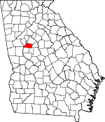
Spalding County, Georgia Basics:


Spalding County Georgia - Government Site

Population: 63,871
Area: 196 square miles
County seat: Griffin
Area code(s) in use: 770
Time zone: EST
High school graduate or higher: 76.1%
Bachelor's degree or higher: 15.6%
Median household income: $40,655
Persons in poverty: 21.6%
Home ownership rate: 62.5%
Mean travel time to work: 28.5 minutes


Adjacent counties:
Butts  Clayton  Coweta  Fayette  Henry  Lamar  Meriwether  Pike  

Find in Georgia

Map of the Spalding County area


Our detail map of Spalding County shows the Spalding County, Georgia boundary lines and other interesting items.

Places in Spalding County, Georgia

  Airports     show all on map

Beaverbrook Aerodrome, Brook Bridge Aerodrome, Cedar Ridge Airport, Griffin-Spalding County Airport, Pecan Patch Airstrip, Pinebrook Estates Airport

  Buildings     show all on map

Georgia State Patrol Troop D Post 1 Griffin, Griffin City Hall, Griffin Diversion Center, Griffin Fire and Rescue Station 1, Griffin Fire and Rescue Station 2, Griffin Fire and Rescue Station 3, Griffin Police Department, Hawkes Library, Spalding County Correctional Institution, Spalding County Courthouse, Spalding County Fire Department Station 1 Headquarters, Spalding County Fire Department Station 2, Spalding County Fire Department Station 3, Spalding County Fire Department Station 4, Spalding County Fire Department Station 5, Spalding County Fire Department Station 6, Spalding County Jail, Spalding County Sheriff's Department

  Cemeteries     show all on map

Bethany Cemetery, Blanton Cemetery, Bostick Cemetery, Breed Cemetery, Ferguson Cemetery, Griffin Memorial Gardens, Henley-Heflin Cemetery, John Bates Family Cemetery, Lindsey Cemetery, Maddox Cemetery, Manley Cemetery, New Oak Cemetery, Oak Hill Cemetery, Ogletree Cemetery, Old Salem Cemetery, Parham Cemetery, Patrick Cemetery, Providence Cemetery, Slayton Cemetery, Stonewall Cemetery, Union Cemetery

  Census     show all on map

Blantons Mill Division (historical), East Griffin Census Designated Place, Experiment Census Designated Place

  Churches     show all on map

Achaia Baptist Church, Baptist Tabernacle, Barrow Church, Bethany Church, Bethel Grove Church, Calvary Baptist Church, Calvary Church, Central Lake Church, Christ our Savior Lutheran Church, Church of Christ, Church of Christ, Church of Christ (historical), Church of God, Church of Prophecy, Community Chapel Church, Corinth Baptist Church, County Line Church, Damascus Church, Devotie Baptist Church, Digbey Church, Eighth Street Baptist Church, Fairview Church, Faith Baptist Church, Faith Temple Assembly of God Church, First Assembly of God Church, First Baptist Church, First Christian Church, First Congregational Church, First Fellowship Church, First Methodist Episcopal Church South (historical), First Presbyterian Church, First United Methodist Church, Grace Baptist Church, Grace Fellowship Church, Hammond Drive Baptist Church, Hanleiter United Methodist Church, Haven Chapel, Heck Chapel United Methodist Church, Highland Baptist Church, Holly Grove Church, Hosama Church, Kincaid Memorial United Methodist Church, Liberty Spring Church, Lighthouse Church, McDonough Road Baptist Church, McIntosh Church, Midway Church, Mount Calvary Church, Mount Pleasant Baptist Church, Mount Zion Church, Mount Zion Church, Mount Zion First Baptist Church, New Salem Church, Oak Grove Church, Oak Hill Baptist Church, Orchard Hill Church, People Church, Plainview Church, Pleasant Grove Church, Pleasant Grove Church, Pomona Baptist Church, Pomona United Methodist Church, Providence Baptist Church, Red Oak Church, Rehoboth Church, Ringgold Church, Rising Star Baptist Church, Sacred Heart Catholic Church, Saint George Episcopal Church, Saint John Lutheran Church, Saint Luke Church, Saint Phillip African Methodist Episcopal Church, Salem Church (historical), Second Baptist Church, Seventh Day Adventist-Dickerson Church, Sharon Baptist Church, Southside Church, Sunny Side First Baptist Church, Teamon Church, Trinity Christian Methodist Episcopal Church, Union Church, United Church, Vaughn Church, Victory Tabernacle Church of God, Victory Temple Assembly of God Church, Vineyard Baptist Church, Wesleyan Methodist Church, West Griffin Holiness Church, West Sunny Side Church, Westside Church of Christ, Wildwood Church, Will of God Apostolic Church, Wolf Creek Baptist Church, Zion Temple Holiness Church

  Dams     show all on map

Central Lake Dam, Cheatam Lake Dam, Childers Lake Dam, Crouch Dam Number One, Crouch Lake Dam Number Three, Crouch Lake Dam Number Two, Dougherty Lake Dam, Dundee Lake Dam, East Crystal Lake Dam, Heads Creek Dam, Horton Lake Dam, Johnson Lake Dam, Louise Lake Dam, Mallory Lake Dam, Mathis Lake Dam, Mize Lake Dam, Morris Lake Dam, North Crystal Lake Dam, Parks Lake Dam, Regents Lake Dam, Shappard Lake Dam, Shoal Creek Lake Dam, Southern Fruit Lake Dam, Southern Fruit Lake Dam B, Sowell Lake Dam, Taylors Lake Dam, Twilly Lake Dam, West Crystal Lake Dam, Williams Lake Dam

  Hospitals     show all on map

Griffin-Spalding County Health Center, Spalding Regional Medical Center

  Lakes     show all on map

Syes Lake

  Locales     show all on map

Cabin Creek Golf Course, Camp Jackson, College Hill Shopping Center, Dovedown Shopping Center, Ellis Crossing Shopping Center, Expressway Village Shopping Center, Griffin Country Club, Market Square of Griffin Shopping Center, North Griffin Square Shopping Center, Northgate Shopping Center, Oxford Village Shopping Center, Pirkle Campground, Spalding Square Shopping Center, Spalding Village Shopping Center, Vineyard Village Shopping Center, West Solomon Shopping Center

  Mines     show all on map

Griffin Quarry

  Parks     show all on map

Griffin Commerical Historic District

  Populated Places     show all on map

Birdie, Blantons Mill, Burdett (historical), Caruso, East Griffin, Esmond, Experiment, Griffin, Highland Mills, Orchard Hill, Pleasant Grove, Pomona, Rio, Rover, Steeles Mill, Sunny Side, Towalaga, Valdo (historical), Vaughn, Walker Mill, Zetella

  Post Offices     show all on map

Griffin Post Office

  Reservoirs     show all on map

Central Lake, Cheatam Lake, Childers Lake, Crouch Lake Number Three, Crouch Lake Number Two, Dougherty Lake, Dundee Lake, East Crystal Lake, Heads Creek, Heads Creek Reservoir, Horton Lake, Johnson Lake, Louise Lake, Mallory Lake, Mathis Lake, Mize Lake, Morris Lake, North Crystal Lake, Parks Lake, Regents Lake, Shappard Lake, Shoal Creek Lake, Southern Fruit Lake, Southern Fruit Lake B, Sowell Lake, Taylors Lake, Twilly Lake, Upper Towaliga Reservoir, West Crystal Lake, White Lake, Williams Lake

  Schools     show all on map

A Z Kelsey Academy, Anne Street Elementary School, Annie Shockley Grade School (historical), Atkins School (historical), Atkinson Elementary School, Beaverbrook Elementary School, Carver Road Middle School, Cora Nimmor School (historical), Cowan Road Elementary School, Cowan Road Middle School, Crescent Elementary School, East Griffin Elementary School, Elementary Enrichment Center, Fairmont School, Flynt Middle School, Flynt Street Middle School, Fourth Ward School, Futral Road Elementary Charter School, Grace Fellowship Christian School, Griffin Academy, Griffin Christian Academy and High School, Griffin High School, Griffin Spalding Alternative School, Griffin Technicial College, Haven Chapel School (historical), Highland Mills School (historical), Jackson Road Elementary School, Jordan Hill Road Elementary School, Kelsey School, Kennedy Road Middle School, Kincaid School, Moore Elementary School, Moreland Road Elementary School, Northside School, Orrs Elementary School, Pleasant Grove School (historical), Sacred Heart School, Spalding County Junior High School, Spalding High School, Sunny Side School, Taylor Street Middle School, Third Ward School, Vineyard School, West Griffin School

  Streams     show all on map

Bear Creek, Flat Creek, Grape Creek, Heads Creek, Ison Branch, Line Creek, Rehoboth Baptism Branch, Shoal Creek, Thompson Creek, Troublesome Creek, Wasp Creek, Wildcat Creek

  Summits     show all on map

Barrow Hill

  Towers     show all on map

WGRI-AM (Griffin), WHIE-AM (Griffin), WKEU-AM (Griffin), WKEU-FM (Griffin), WMVV-FM (Mcdonough),

Spalding County, Georgia Population By Race (2012 estimate)

RacePopulation
WhiteSpalding County White population 40,68640,685  
BlackSpalding County Black population 21,20521,205
MixedSpalding County Mixed population 1,0221,021
AsianSpalding County Asian population 639638
American IndianSpalding County American Indian population 255255
Hawaiian & Pacific IslanderSpalding County Hawaiian & Pacific Islander population 6463

Additional population tables :
State population table
Georgia population by county