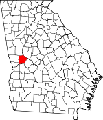
Talbot County, Georgia Basics:
Talbot County Georgia - Government Site
Population: 6,534
Area: 391 square miles
County seat: Talbotton
Area code(s) in use: 706
Time zone: EST
High school graduate or higher: 77.9%
Bachelor's degree or higher: 12.1%
Median household income: $26,750
Persons in poverty: 23.4%
Home ownership rate: 77.4%
Mean travel time to work: 28.9 minutes
Adjacent counties:
Chattahoochee Harris Marion Meriwether Muscogee Taylor Upson
Places in Talbot County, Georgia
C & W Air Park,
Jumpin j Airport,
Prattsburg Airport,
Rainbow Field Airport Pasley Shoals Chris Collier Bridge,
Parkers Bridge (historical),
Wynns Bridge Talbot County Courthouse,
Talbot County Emergency Medical Services,
Talbot County Fire Department Box Springs Station,
Talbot County Fire Department Flint Hill Station,
Talbot County Fire Department Geneva Station,
Talbot County Fire Department Junction City Station,
Talbot County Fire Department Oneal Station,
Talbot County Fire Department Woodland Station,
Talbot County Jail,
Talbot County Sheriff's Office,
Talbotton Police Department,
Woodland Police Department Adams Cemetery,
Carter Cemetery,
Cobb Cemetery,
Culpepper Cemetery,
Flint River Cemetery,
Geneva Cemetery,
Hollis Cemetery,
Liberty Hill Cemetery,
Macedonia Cemetery,
Miller-Holmes Cemetery,
Neel Cemetery,
Nelson Cemetery,
Oak Hill Cemetery,
Pineview Memorial Gardens,
Pye Cemetery,
Reedy Cemetery,
Steed Cemetery,
Valley Grove Cemetery Bethel Church,
Bluff Spring Church,
Box Springs Church,
Box Springs Methodist Church,
Camel Chapel,
Collingsworth Church,
Concord Church,
Corinth Methodist Church,
Crossroad Church,
Evans Chapel,
Flint River Church,
Friendship Church,
Hobar Church,
Humble Zion Church,
Liberty Hill Baptist Church (historical),
Mathews Chapel,
Mount Airy Church,
Mount Carmel Church,
Mount McCatherine Church,
Mount Paron Church,
Mount Pilgrim Church,
Mount Zion Church,
Mount Zion Church (historical),
New Salem Church,
Oak Grove Church,
Olive Branch Methodist Church,
Philadelphia Church,
Pine Level Church,
Powell Church,
Rock Church,
Saint Pauls Church,
Sardis Church,
Sardis Church (historical),
Shiloh Church,
Spinks Chapel (historical),
Sweet Home Church,
Talbotton Baptist Church,
Talbotton United Methodist Church,
Upatoi Church,
Valley Grove Church,
Welcome Church,
Zion Episcopal Church Spewrell Bluff Jacks Ferry (historical),
Rocky Shoals Ford Badcock Lake Dam,
Benson Lake Dam,
Copeland Lake Dam,
County Park Lake Dam,
Fielder Lake Dam,
Floyds Lake Dam,
Franklins Pond Dam,
Hellens Lake Dam,
Jorden Dam,
Juniper Lake Dam,
Kimbrilugh Dam,
Lee Lake Dam,
Matthews Lake Dam,
Matthews Lake East Dam,
Meadows Lake Dam,
Oak Mountain Spring Lake Dam,
Pearsons Lake Dam,
Swift Dam,
Woodland Lake Dam Carlisle Gap,
Dunn Gap,
Helm Gap,
Hodo Gap,
Stephenson Gap,
Tally Gap Adams Island,
Gibson Island,
Hickman Island,
Ivy Island,
Owens Island,
Seven Islands Cooliks Lake,
Ransome Lake Juniper Station,
Lazy Acres Plantation,
Rocky Heights Plantation (historical),
Steed Plantation (historical),
Turners Mill (historical) Le Vert Historic District,
Methodist Memorial Park Baldwinville,
Baughville,
Beall,
Belleview,
Box Springs,
Brownsand,
Centerville,
Cunningham Crossroads,
Flint Hill,
Geneva,
Greens Mill,
Hawkins Crossroads,
Junction City,
Oak Mountain Spring (historical),
Olive Branch,
Paschal (historical),
Pleasant Hill,
Po Biddy Crossroads,
Poplar Crossroads,
Prattsburg,
Sardis,
Talbotton,
Tax Crossroads,
Woodland,
Ypsilanti Box Springs Post Office Badcock Lake,
Benson Lake,
Copeland Lake,
County Park Lake,
Fielder Lake,
Floyds Lake,
Franklins Pond,
Hellens Lake,
Jordan Lake,
Jorden Lake,
Juniper Lake,
Lee Lake,
Matthews Lake,
Matthews Lake East,
Meadows Lake,
Oak Mountain Spring Lake,
Pearsons Lake,
Swift Lake,
Woodland Lake Baldwinville School (historical), Bellevue Academy (historical),
Box Spring School,
Carter School, Centerville Academy (historical),
Centerville School (historical),
Collingsworth Institute (historical), Flint Hill School (historical),
Flint River School (historical),
Franklin Academy (historical),
Geneva School,
Le Vert College (historical),
Mount Airy School (historical),
Pine Grove Academy (historical), Pleasant Hill School (historical), Prattsburg Academy (historical), Sardis School (historical),
Talbot County High School (historical), Talbotton Male School Academy (historical),
Talbotton School,
Valley Grove Academy (historical),
Washington Academy (historical),
Woodall School,
Woodland Academy,
Woodland School (historical), Ypsilanti School (historical)
Oak Mountain Spring Baker Creek,
Barfield Creek,
Black Creek,
Black River,
Blackman Branch,
Coleoatchee Creek,
Dry Creek,
Edwards Creek,
Gin Creek,
Gum Creek,
Hawkins Creek,
Hinton Creek,
Jack Branch,
Juniper Creek,
Kimbrough Creek,
Lazer Creek,
Mahone Branch,
Marshall Creek,
Mill Creek,
Mossy Branch,
Mud Creek,
Potters Creek,
Richland Creek,
Riley Branch,
Rockmore Creek,
Rush Creek,
Russell Branch,
Scott Creek,
Scroggins Branch,
South Fork Upatoi Creek,
South Prong Marshall Creek Gulf Mountain,
Rockhouse Mountain,
Turkey Knob Woodland Lookout Tower,
WVFJ-FM (Manchester),

