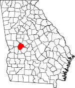
Taylor County, Georgia Basics:
Taylor County Georgia - Government Site
Population: 8,403
Area: 377 square miles
County seat: Butler
Area code(s) in use: 478
Time zone: EST
High school graduate or higher: 73.0%
Bachelor's degree or higher: 8.8%
Median household income: $28,402
Persons in poverty: 29.2%
Home ownership rate: 66.9%
Mean travel time to work: 26.1 minutes
Adjacent counties:
Crawford Macon Marion Peach Schley Talbot Upson
Places in Taylor County, Georgia
Butler Municipal Airport Butler Emergency Medical Services,
Butler Fire Department,
Butler Police Department,
Central Fire Department,
Howard Volunteer Fire Department,
Mauk Volunteer Fire Department,
Panhandle Volunteer Fire Department,
Potterville Volunteer Fire Department,
Reynolds Police Department,
Reynolds Volunteer Fire Department,
Rupert Volunteer Fire Department,
Taylor County Courthouse,
Taylor County Jail,
Taylor County Sheriff's Office,
Western Pre-Release Center Antioch Cemetery,
Bethel Cemetery,
Bethlehem Cemetery,
Bloodworth Cemetery,
Chambliss Cemetery,
Crowell Cemetery,
Glover Cemetery,
Harris Cemetery,
Lieutenant Colonel Brewer Cemetery,
Lockhart Cemetery,
Lucas Cemetery,
Mauk Cemetery,
Midway Cemetery,
Mount Olive Cemetery,
Mount Pisgah Cemetery,
Mount Sinai Cemetery,
New Hope Cemetery,
New Prospect Cemetery,
Newsom Cemetery,
Pine Level Cemetery,
Prosperity Cemetery,
Sand Bethel Cemetery,
Scott-Bussy Cemetery,
Trinity Cemetery,
Turners Chapel Cemetery,
Wainwright Cemetery,
Wesley Cemetery,
White Hill Cemetery Butler-Rupert Division (historical),
Howard Census Designated Place Antioch Baptist Church,
Antioch Church,
Bethel Church,
Bethel Church,
Bethlehem Church,
Beulahland Church,
Charing Church,
Church of God,
Crowells Church,
Damascus Church,
Evergreen Church,
Faith Church,
Gordon Grove Church,
Howard Church,
Lebanon Church,
Mauk Church,
Midway Church,
Mount Gilliard Church,
Mount Nebo Church,
Mount Olive Church,
Mount Pisgah Church,
Mount Sinai Church,
New Free Run Church,
New Hope Church,
New Prospect Church,
New Providence Church,
New Zion Church,
Pilgrim Rest Church,
Prosperity Church,
Saint James Church,
Sand Bethel Church,
Taylor Mill Missionary Church,
The Church,
Trinity Church,
Turners Chapel,
Union Church,
Wesley Church,
White Hill Church,
Zion Hill Church Grays Ferry (historical),
Islands Ford,
Sulenojuhnene Ford,
Trices Ferry (historical) Bell Dam,
Brunson Lake Dam,
Carl Brown Lake Dam,
Garant Lake Dam,
Garretts Pond Dam,
Hinton Lake Dam,
Hortmans Pond Dam,
Lake Mary Dam,
Parks Millpond Dam,
Ricks Lake Dam,
Rustins Pond Dam,
Wainwright Lake Dam,
Watson Lake Dam,
Whatley Lake Dam Harris Island,
Reeves Island Dead River,
Watson Millpond Hootenville District,
Taylor County Holiness Camp Ground Beechwood,
Butler,
Carsonville,
Charing,
Fickling Mill,
Five Points,
Goldson,
Griffith, Hootenville (historical),
Howard,
Jarrell,
Mauk,
Mizell,
Norwich,
Panhandle,
Potterville,
Reynolds,
Rupert,
Southland,
Wesley Alisgen Post Office (historical), Barnards Post Office (historical), Butler Post Office, Carsonville Post Office (historical),
Charing Post Office (historical), Daviston Post Office (historical), Duggers Post Office (historical), Fickling Post Office (historical), Fletcher Post Office (historical), Graball Post Office (historical),
Howard Post Office, Kipling Post Office (historical),
Mauk Post Office, Mizell Post Office (historical), Norwich Post Office (historical), Philmon Post Office (historical), Potterville Post Office (historical), Reynolds Post Office, Royal Post Office (historical),
Rupert Post Office, Southland Post Office (historical), Wilchar Post Office (historical)
Reeves Shoals Bell Lake,
Brunson Lake,
Carl Brown Lake,
Garant Lake,
Garretts Pond,
Hinton Lake,
Hortmans Pond,
Lake Mary,
McCants Millpond,
Minors Millpond,
Parks Millpond,
Ricks Lake,
Rustins Pond,
Suggs Millpond,
Taylor Mill Lake,
Wainwright Lake,
Watson Lake,
Whatley Lake Damascus School (historical),
Taylor County Elementary School,
Taylor County High School Beaver Creek,
Black Bottom Creek,
Black Creek,
Caney Branch,
Duck Creek,
Fraser Branch,
Griffin Branch,
Jackson Branch,
Juniper Branch,
Little Patsiliga Creek,
Little Vine Creek,
Little Whitewater Creek,
Mill Creek,
Patsiliga Creek,
Rambulette Creek,
Timms Creek,
Turkey Branch Beechwood Swamp Beulah Lookout Tower,

