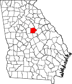
Putnam County, Georgia Basics:


Putnam County Georgia - Government Site

Population: 21,184
Area: 345 square miles
County seat: Eatonton
Area code(s) in use: 706
Time zone: EST
High school graduate or higher: 82.0%
Bachelor's degree or higher: 18.8%
Median household income: $40,115
Persons in poverty: 15.2%
Home ownership rate: 76.7%
Mean travel time to work: 28.4 minutes


Adjacent counties:
Baldwin  Greene  Hancock  Jasper  Jones  Morgan  

Find in Georgia

Map of the Putnam County area


Our detail map of Putnam County shows the Putnam County, Georgia boundary lines and other interesting items.

Places in Putnam County, Georgia

  Airports     show all on map

Deerfield Landing Airport, Sebastian Cove Airport

  Buildings     show all on map

Bledsoe-Green House Museum, Eatonton City Hall, Eatonton Fire Department, Eatonton Police Department, Harllee Branch Power Plant, Putnam - Morgan County Fire Department Station 11 Sugar Creek, Putnam County Correctional Institution (historical), Putnam County Courthouse, Putnam County Fire Department Long Shoals Station, Putnam County Fire Department Station 2, Putnam County Fire Department Station 3, Putnam County Fire Department Station 5, Putnam County Jail, Putnam County Library, Putnam County Sheriff's Department, Rockville Fire Department Station 6, Twin Bridges Fire Department, Uncle Remus Museum, United States Department of Agriculture Forest Service Oconee Ranger District

  Cemeteries     show all on map

Crestlawn Memorial Gardens, Hearnville Cemetery, Key Cemetery, Pine Grove Cemetery

  Census     show all on map

Crooked Creek Census Designated Place

  Churches     show all on map

Avalona Church (historical), Bethleham Church, Brown Chapel, Calvary Church, Central Church, Concord Church, Corinth Church (historical), Crooked Creek Church, Eatonton Church, Eton Church (historical), First Baptist Church, Free Gift Church, Friendship Church, Gregory Mission (historical), Harmony Church, Henderson Grove Church, Hunts Chapel, Imperial Church, Jefferson Church, Jenkins Grove Chapel, Lake Shore Church, Lakeside Church, Lees Chapel (historical), Lone Oak Church, Manley Memorial Church, Marshall Church, Martins Hill Church (historical), Mission Church (historical), Mount Ararat Church, Mount Calvin Church, Mount Gilead Church, Mount Pleasant Church, Mount Zion Church, New Bethel Church, New Hope Church (historical), New Providence Church, Oconee Church, Philadelphia Church, Pierces Chapel Church, Pinkerton Grove Church, Pleasant Grove Church, Raymouth Church, Reids Chapel, Resseau Church, Rooty Creek Church, Saint Pauls Church, Saint Pauls Church, Saints Mission (historical), Sandhill Church (historical), Stanfordville Church (historical), Texas Church, Tirzah Church (historical), Union Chapel Church, Ward Chapel, Wesley Chapel, Whites Chapel (historical), Zachary Chapel (historical)

  Crossings     show all on map

Humbers Old Ferry (historical), Littles Ferry (historical), Martins Ferry (historical), Old Millen Ferry (historical), Reids Ferry (historical)

  Dams     show all on map

Ashurst Dam, Basil Lake Dam, Beall Lake Dam, Beall Pond Dam One, Beall Pond Dam Two, Carnes Lake Dam, Davis Lake Dam, Dennis Lake Dam, Dodson Pond Dam, Experiment Lake Number One Dam, Georgia Experiment Station Dam, Kraft Lake Dam, Reeses Lake Dam, Rock Eagle Lake Dam, Rooty Creek Structure Number 21 Dam, Rooty Creek Structure Number 27 Dam, Rooty Creek Structure Number Five Dam, Rossee Lake Dam, Walker Lake Dam

  Forests     show all on map

Oconee National Forest

  Hospitals     show all on map

Putnam General Hospital

  Locales     show all on map

Cedar Creek Check Station, Central Georgia Experiment Station, Culp Hunt Camp, Eatonton-Putnam North Industrial Park, Lazenberry Hunt Camp, Lazenberrys Mill (historical), Little Glady Hunt Camp, Little River Hunt Camp, Martins Mill (historical), Mathis Hunt Camp, Mount Coilead Hunt Camp, Murder Creek Falls Hunt Camp, Murder Creek Hunt Camp, Murder Creek Research Natural Area, Oak Grove Hunt Camp, Oconee Work Center, Presley Mill (historical), Rock Creek Hunt Camp, Sinclair Lake Recreation Area, South Putnam Industrial Park, Sugar Creek Boat Ramp, Twin Bridges Hunt Camp, Uncle Remus Golf Course, Wheelers Mill (historical), Willard Hunt Camp

  Parks     show all on map

Adiel Sherwood Monument, Cedar Creek Wildlife Management Area, Central Georgia Branch Station Wildlife Management Area, Eatonton Historic District, Oconee Springs Park, Rock Eagle Lake 4-H Club Roadside Park Picnic Area, Rock Eagle Monument

  Populated Places     show all on map

Apollo (historical), Clopton (historical), Dennis, Eatonton, Flat Rock, Glades Cross-Roads, Glenwoods Spring (historical), Hallwood, Harmony, Hearnville (historical), Hunts, Huron (historical), Imperial, Jefferson, Linchburg, Meda, Nona, Note, Oconee Springs, Phoenix, Reids Crossroads, Resseaus Crossroads, Rockville, Rudden, Spivey (historical), Stanfordville, The Glades (historical), Turnwold, Union Hill, Warfield, Willard

  Post Offices     show all on map

Eatonton Post Office

  Rapidss     show all on map

Grabel Shoals, Riley Shoals

  Reservoirs     show all on map

Ashurst Pond, Basil Lake, Beall Lake, Beall Pond One, Beall Pond Two, Carnes Lake, Davis Lake, Dennis Lake, Dodson Pond, Experiment Lake Number One, Georgia Experiment Station Lake, Kraft Lake, Lake Oconee, Reeses Lake, Rock Eagle Lake, Rooty Creek Structure Number 21 Lake, Rooty Creek Structure Number 27 Lake, Rooty Creek Structure Number Five Lake, Rossee Lake, Walker Lake

  Schools     show all on map

Berean Christian School, Central Georgia Technical College - Putnam County Center, Central School (historical), Dennis Grove School (historical), Florence School (historical), Florence School (historical), Freeman Grove School (historical), Gatewood Christian School, Hearnville Academy (historical), Jones Grove School (historical), Mission School (historical), Mount Ararat School (historical), Mount Calvary School (historical), Mount Zion School (historical), Phoenix School (historical), Putnam Alternative Success School, Putnam County Elementary School, Putnam County High School, Putnam County Middle School, Putnam-Jasper Training Center, Salem School (historical), Union School (historical), Wright School (historical)

  Streams     show all on map

Badger Creek, Baker Branch, Baltimore Branch, Bay Branch, Bear Creek, Beaverdam Creek, Big Indian Creek, Blue Branch, Bryant Branch, Buckshot Branch, Cattail Branch, Cattail Branch, Clarks Fork, Cold Branch, Cold Branch, Crooked Creek, Dance Branch, Denham Branch, Glade Branch, Glady Creek, Herndon Branch, Highlog Branch, Hitchcock Branch, Hone Branch, Hurricane Branch, Jacks Fork, Jenkins Branch, Lick Creek, Little Branch, Little Creek, Little Creek, Little Glady Creek, Martin Branch, Murder Creek, Pearson Creek, Reece Branch, Rock Creek, Rocky Branch, Rooty Creek, Rush Creek, Tanyard Branch, Turkey Creek, Weaver Branch, Weaver Branch, Wolf Creek

  Towers     show all on map

Mathis Lookout, Moseley Lookout Tower, Rockville Lookout Tower, WKVQ-AM (Eatonton)

  Trails     show all on map

Twin Bridges Trail,

Putnam County, Georgia Population By Race (2012 estimate)

RacePopulation
WhitePutnam County White population 14,99814,998  
BlackPutnam County Black population 5,7205,719
MixedPutnam County Mixed population 191190
AsianPutnam County Asian population 127127
American IndianPutnam County American Indian population 8584
Hawaiian & Pacific IslanderPutnam County Hawaiian & Pacific Islander population 6463

Additional population tables :
State population table
Georgia population by county