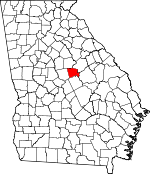
Baldwin County, Georgia Basics:


Baldwin County Georgia - Government Site

Population: 46,373
Area: 258 square miles
County seat: Milledgeville
Area code(s) in use: 478
Time zone: EST
High school graduate or higher: 81.0%
Bachelor's degree or higher: 19.3%
Median household income: $35,278
Persons in poverty: 28.7%
Home ownership rate: 58.6%
Mean travel time to work: 20.1 minutes


Adjacent counties:
Hancock  Jones  Putnam  Washington  Wilkinson  

Find in Georgia

Map of the Baldwin County area


Our detail map of Baldwin County shows the Baldwin County, Georgia boundary lines and other interesting items.

Places in Baldwin County, Georgia

  Airports     show all on map

Baldwin County Airport, Brookline - Meadowmere Airport, Central State Hospital Heliport

  Bars     show all on map

Furman Shoals, Toms Shoals

  Bends     show all on map

Big Bend

  Buildings     show all on map

Baldwin County Courthouse, Baldwin County Fire and Rescue Department Station 1 Headquarters, Baldwin County Fire and Rescue Department Station 2 Central State Hospital, Baldwin County Fire and Rescue Department Station 3, Baldwin County Fire and Rescue Department Station 4, Baldwin County Fire and Rescue Department Station 5, Baldwin County Fire and Rescue Department Station 6, Baldwin County Fire and Rescue Department Station 7, Baldwin County Fire and Rescue Department Station 8, Baldwin County Jail, Baldwin County Sheriff's Office, Baldwin State Prison, Georgia College and State University Police, Georgia Old State Capitol, Georgia State Patrol Troop E Post 33 Milledgeville, Georgia State Penitentiary (historical), Ina Dillard Russell Library, Mary Vinson Memorial Library, Milledgeville City Hall, Milledgeville Fire Department Station 1, Milledgeville Fire Department Station 2, Milledgeville Police Department, Miller Gymnasium, Old Governors Mansion, Russell Auditorium

  Cemeteries     show all on map

Baldwin Memorial Gardens, Black Springs Baptist Churchyard, Bland Cemetery, Bone Cemetery, Camp Creek Cemetery, David Hill Cemetery, Fishing Creek Cemetery, Georgia Veterans Memorial Cemetery, Green Cemetery, Harmony Churchyard, Hopewell Methodist Churchyard, Howe Cemetery, Humphries Cemetery, Jacob Gumm Cemetery, John Arnold Cemetery, Leonard Smith Cemetery, Memory Hill Cemetery, Montpelier Methodist Churchyard, Mount Olive Churchyard, Mount Pleasant Baptist Churchyard, Newton Cemetery, Oak Grove Cemetery, Rogers Cemetery, Salem Baptist Churchyard, Sand Hill Cemetery, Sanford Cemetery, Stiles Cemetery, Union Hill Methodist Churchyard, West View Cemetery

  Census     show all on map

Hardwick Census Designated Place

  Churches     show all on map

Alto Baptist Church, Antioch Church, Baldwin Church, Bethel Church, Bible Church, Black Springs Baptist Church, Browns Church, Camp Creek Church, Clark Chapel (historical), Coopers Hill Church, County Line Church, County Line Church, El Bethel Baptist Church, Emmanuel Church, Fellowship Church, First Baptist Church, First Methodist Church, First Presbyterian Church, Flippers Chapel African Methodist Episcopal Church, Friendship Church, Greenpasture Church, Gumm Hill Church, Hardwick Baptist Church, Hardwick Christian Church, Hardwick Methodist Church, Hardwick Progressive Primitive Baptist Church, Harmony Church, Hope Church, Hopewell Church, Lees Chapel, Mitchell Zion Church, Montpelier Church, Mosleyville Church, Mount Calvary Church, Mount Hope Church, Mount Pleasant Church, Mount Zion Church, Neriah Church, Northside Baptist Church, Oak Grove Church, Oak Grove Church Number 2, Oak Grove Methodist Church, Pardue Tabernacle, Pine Ridge Church, Pleasant Grove Church, Rock Mill Church, Saint Marys Church, Saint Pauls Church, Saint Pauls Church, Saint Stephens Episcopal Church, Salem Church, Sandtown Church, Scotts Chapel, Second Macedonia Church, Shiloh Church, Sinclair Church, Spring Hill Church, Tabernacle Church, The Church of Jesus Christ of Latter Day Saints, Torrance Chapel, Trinity Christian Methodist Episcopal Church, Union Baptist Church, Union Hill Methodist Church, Vaughn Chapel (historical), Vaughns Church, Walker Chapel (historical), Wesley Chapel African Methodist Episcopal Church (historical)

  Crossings     show all on map

Averills Ferry (historical), McKinzies Ferry (historical), Tucker Ferry (historical)

  Dams     show all on map

Ashfield Lake Dam, Baldwin County Recreation Lake Dam, Beckham Lake Dam, Burke Lake Dam, Carrington Woods Lake Dam, Forestry Pond Dam Number One, Forestry Pond Dam Number Two, Fountain Lake Dam, Fountain Lake Dam, Georgia Lake Dam Number Nine, Georgia State Hospital Lake West Dam, Grimes Pond Dam, Hollinshead Pond Dam, Hospital Lake Number One Dam, Hospital Lake Number Two Dam, Ivey Lake Dam, John Milledge Academy Dam, Lake Laurel Dam, McClure Lake Dam, McDade Lake Dam, Patrick Lake Dam, Peavy Lake Dam, Scott Lake Dam, Simpsons Lake Dam, Willoughby Lake Dam, Youth Development Center Dam

  Forests     show all on map

Baldwin State Forest

  Hospitals     show all on map

Allen Hospital, Marion Ennis Health Center (historical), Marvin Parks Memorial Hospital, Oconee Regional Medical Center, Regional Psychiatric Division of Central State Hospital, Scott Hospital (historical)

  Islands     show all on map

Buzzard Island, Carter Island, Collins Island (historical), McMillan Island

  Lakes     show all on map

Bridge Lake, Gumm Pond, High Bridge Lake, Peachtree Lake, Powell Lake (historical), Spring Lake, Stob Lake

  Locales     show all on map

Asylum Station (historical), Fraley Ferry (historical), Hatcher Square Mall Shopping Center, Milledgeville Country Club, Oconee Siding (historical), Rock Landing, Stevens Pottery, Town and Country Shopping Center, Trinity United Methodist Camp

  Military     show all on map

Fort Wilkinson (historical)

  Parks     show all on map

Governors Square (historical), Milledgeville Historic District, Penitentiary Square (historical), State House Square, Walter B Williams Junior Park

  Populated Places     show all on map

Allen Mill (historical), Allenwood, Black Spring, Blandy, Browns Crossing, Carling (historical), Coopers, Hardwick, Harrisburg, Meriwether, Milledgeville, Montpelier, Mount Pleasant, Oconee Old Town (historical), Pancras, Sandtown, Scottsboro, The Colony, Underwood

  Post Offices     show all on map

Milledgeville Post Office

  Rapidss     show all on map

Fraley Shoals (historical)

  Reservoirs     show all on map

Ashfield Lake, Baldwin County Recreation Lake, Beckham Lake, Burke Lake, Forestry Pond Number Two, Fountain Lake, Fountain Lake, Georgia Lake Number Nine, Georgia State Hospital Lake, Georgia State Hospital Lake West, Grimes Pond, Hollinshead Pond, Hospital Lake Number One, Hospital Lake Number Two, Ivey Lake, John Milledge Academy Lake, Lake Laurel, Lake Sinclair, McClure Lake, McDade Lake, Milledgeville City Lake, O'Quinn Pond, Patrick Lake, Peavy Lake, Reedy Creek Lake, Scott Lake, Simpsons Lake, White Lake, Willoughby Lake, Youth Development Center Lake

  Schools     show all on map

Baldwin County Academy (historical), Baldwin High School, Baldwin School, Baldwin Vocational School, Bass School (historical), Blandy Hills Elementary School, Boddie Middle School, Carver School, Central Georgia Technical College - Milledgeville Campus, Creekside Elementary School, Davis School, Eagle Ridge Elementary School, Faith Christian Academy, Fishing Creek School, Georgia College and State University, Georgia Female College (historical), Georgia Military College, Georgia State Training School for Boys, Harrisburg School, Hermitage Female Seminary (historical), John Milledge Academy Christian School, June Hill School (historical), Midway Elementary School, Midway Seminary (historical), Milledgeville Academy (historical), Milledgeville Female Academy (historical), Milledgeville Seminary (historical), Northside School, Oak Hill Middle School, Peabody Practice School, Scottsboro Academy (historical), Scottsboro Male Academy (historical), Southside School, Torrance Chapel School (historical), Trilby School (historical)

  Springs     show all on map

Moran Spring

  Streams     show all on map

Beaverdam Creek, Buck Creek, Buck Creek, Camp Creek, Cedar Creek, Champion Creek, Dead River, Ferry Branch, Fishing Creek, Flatrock Branch, Gantry Creek, Goss Creek, Gumm Creek, Island Creek, Little Camp Creek, Little Fishing Creek, Little River, Little Rocky Creek, Moore Creek, Nancy Branch, Potato Creek, Reedy Branch, Reedy Creek, Rocky Creek, Sand Creek, Spring Lake, Tobler Creek, Tomas Lake, Town Creek, Watson Creek

  Towers     show all on map

WKGQ-AM (Milledgeville), WKZR-FM (Milledgeville), WLRR-FM (Milledgeville), WMVG-AM (Milledgeville), WXGC-FM (Milledgeville),

Baldwin County, Georgia Population By Race (2012 estimate)

RacePopulation
WhiteBaldwin County White population 25,78325,783  
BlackBaldwin County Black population 19,15219,152
AsianBaldwin County Asian population 788788
MixedBaldwin County Mixed population 510510
American IndianBaldwin County American Indian population 139139
Hawaiian & Pacific IslanderBaldwin County Hawaiian & Pacific Islander population 4646

Additional population tables :
State population table
Georgia population by county