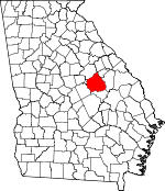
Washington County, Georgia Basics:


Washington County Georgia - Government Site

Population: 20,863
Area: 678 square miles
County seat: Sandersville
Area code(s) in use: 478
Time zone: EST
High school graduate or higher: 76.7%
Bachelor's degree or higher: 10.9%
Median household income: $31,441
Persons in poverty: 24.7%
Home ownership rate: 73.2%
Mean travel time to work: 23.4 minutes


Adjacent counties:
Baldwin  Glascock  Hancock  Jefferson  Johnson  Wilkinson  

Find in Georgia

Map of the Washington County area


Our detail map of Washington County shows the Washington County, Georgia boundary lines and other interesting items.

Places in Washington County, Georgia

  Airports     show all on map

Heidrich Airport, Kaolin Field Airport, Memorial Hospital of Washington County Heliport

  Bridges     show all on map

Chickasawhatchie Bridge, Cobb Bridges, Fenns Bridge, Harrisons Bridge, Harts Ford Bridge, Jackson Bridge, Masseys Mill Bridge, News Bridge, Robinson Bridge, Sheppards Bridge, Thompsons Bridge

  Buildings     show all on map

Davisboro Police Department, Davisboro Volunteer Fire Department, Deepstep Area Volunteer Fire Department, Harrison Police Department, Harrison Volunteer Fire Department, Oconee Police Department, Oconee Volunteer Fire Department, Ohoopee Volunteer Fire Department, Ohoopee Volunteer Fire Department, Riddleville Volunteer Fire Department, Sandersville City Hall, Sandersville Fire Department, Sandersville Police Department, Tennille City Hall, Tennille Fire Department, Tennille Police Department, Warthen Volunteer Fire Department, Washington County Courthouse, Washington County Jail, Washington County Sheriff's Office, Washington State Prison

  Cemeteries     show all on map

Amerson Cemetery, Antioch Cemetery, Antioch Cemetery, Avant Cemetery, Bay Branch Cemetery, Bay Springs Cemetery, Bethany Cemetery, Bethlehem Cemetery, Bridges Cemetery, Brook Cemetery, Brownwood Cemetery, Burgamy Cemetery, Carter Cemetery, Cummings Cemetery, Davisboro City Cemetery, Deepstep Cemetery, Deepstep Cemetery, Downs Cemetery, Forbes Cemetery, Fulford Cemetery, Gordon Cemetery, Halls Cross Roads Cemetery, Harris Cemetery, Hood Cemetery, Jackson Cemetery, John Sparks Cemetery, Jones Cemetery, Joseys Chapel Cemetery, Leverett-Sparks Cemetery, Memorial Gardens, Mineral Springs Cemetery, Mount Gilead Cemetery, Mount Moriah Cemetery, Mount Sinai Cemetery, Moye Cemetery, Murphy Cemetery, New Bethel Cemetery, New Cemetery, New Hope Cemetery, Newsome Cemetery, Oak Grove Cemetery, Ohoopee Cemetery, Old Bethesda Cemetery, Orr Cemetery, Pate Cemetery, Pete Cemetery, Piney Mount Cemetery, Pleasant Grove Cemetery, Pleasant Plains Cemetery, Pleasant Springs Cemetery, Red Field Cemetery, Ruthford Cemetery, Sandersville City Cemetery, Sinquefield Cemetery, Sisters Cemetery, Smith Cemetery, Smith Cemetery, Smith Cemetery, Stephen Mills Cemetery, Tabernacle Cemetery, Taylor Cemetery, Trawich Cemetery, Union Cemetery, Veal Cemetery, Washington County Memorial Garden, West Cemetery, Whiteoak Cemetery, Whitfield Cemetery, Woods Cemetery, Woods Cemetery, Zeta Cemetery

  Churches     show all on map

Ammie S Page Memorial Baptist Church, Antioch Baptist Church, Antioch Church, Base Spring Chapel, Bay Spring Church, Beach Grove Church, Beddingfield Church, Bethany Church, Bethesda Church, Bethesda Church, Bethlehem Church, Bold Spring Church, Cabin Hill Church (historical), Camp Springs Church, Chapel Church, Community Church, Deepstep United Methodist Church, Dixon Grove Church, Downs Baptist Church, Embassy Place Church, First Baptist Church, First Christian Church of Sandersville, First Presbyterian Church, First Southern Church, Friendship Baptist Church, Gardners Grove Church of God, Georgia Grove Church, Gordy Grove Church, Grace Episcopal Church, Green Grove Church, Halls Chapel, Harris Methodist Church (historical), Harrison Baptist Church, Henderson Grove Church, Henderson Grove Church, Hodges Hill Church, Holly Spring Church, Jackson Church, Jones Chapel, Jordan Church, Jordan Station Church, Josey Church, Limestone Church, Limestone Church, Marshall Grove Church, May Branch Church, Middle Hill Church, Mineral Springs Church, Minton Springs Church, Mount Gilead Church, Mount Moriah Church, Mount Olive Church, Mount Sinai Baptist Church, Mount Zion Church, Nealer Church, New Bethel Church, New Hope Church, New Hope Church, Oak Grove Church, Oconee Church of God, Ohoopee Church, Old Darien Church, Pine Hill Church, Pine Hill Church, Pine Hill Church, Piney Mount Church, Pleasant Grove Church, Pleasant Plains Church, Pleasant Springs Church, Poplar Springs Baptist Church, Poplar Springs Christian Church, Red Hill Church (historical), Robin Spring Church, Rutherford Primitive Baptist Church (historical), Saint James Church, Saint Pauls African Methodist Episcopal Church, Saint Pauls Church, Saint Williams Roman Catholic Church, Samuel Grove Church, Sandersville United Methodist Church, Sandy Grove Church, Scott Chapel, Sisters Church, Smith Grove Church, Smyrna Church, Spring Hill Church (historical), Springfield Baptist Church, Swint Spring Church, Tabernacle United Methodist Church, Talbot Grove Church, Union Church, Union Church (historical), Union Hill Church, Walker Chapel, Warthen United Methodist Church, White Oak Church, Zion Hope Church

  Crossings     show all on map

Balls Ferry (historical)

  Dams     show all on map

Adams Lake Dam, Adams Pond North Dam, Adams Pond South Dam, American Ind Clay Company Lake Dam, Andrews Pond Dam, Archers Lake Dam, Boatright Lake Dam, Brantley Pond Dam, Bretts Lake Dam, Brown Lake Dam, Burgamy Millpond Dam, Cobb Lake Dam, Dixie Land Lake Dam, Ethridge Lake Dam, Francis Lake Dam, Gilmore Lake Dam Number One, Gilmore Lake Dam Pond Number Two, Gilmore Lake Number Three Dam, Gorbutt Pond Dam, Hamburg Mill Pond Dam, Herds Pond Dam, Hodges Pond Dam, Jackson Lake Dam, Johnson Lake Dam, Jordan Mill Pond Dam, Kings Pond Dam, Lewis Lake Dam, Lower Yarbrough Lake Dam, Mays Millpond Dam, Morris Lake Dam, Pat Pate Dam, Political Pond Dam, Ralph Walker Lake Dam, Segars Lake Dam, Segars Lake Dam, Shephard Lake Dam, Sheppard Lake Dam, Smith Lake Dam, Smith Pond Dam, Smith-Jordan Pond Dam, Taylor Lake Dam, Thiele Kaolin Mining Company Lake Dam, Upper Yarbrough Lake Dam, Walker Pond Dam, Walnut Branch Fishing Lake Dam

  Hospitals     show all on map

Rawlings Sanitarium (historical), Washington County Regional Medical Center

  Lakes     show all on map

Adams Pond, Anderson Pond, Brentley Pond, Hodges New Pond, Hodges Pond, Little Pond, Mays Pond, Morgans Pond, Orrs Pond, Purvis Pond

  Locales     show all on map

Fowlers Store (historical), Hartley Farms, Jordans Mill (historical), Kaolin Plaza Shopping Center, Mays Mill (historical), Tarvers Mill, Twin Cities Plaza Shopping Center

  Parks     show all on map

Church-Smith-Harris Streets Historic District, Hamburg State Park, North Harris Street Historic District, Tennille City Park

  Populated Places     show all on map

Brook Springs, Chalker (historical), Davisboro, Deepstep, Downs, Ennis, Gardner, Goat Town, Halls Crossing, Harrison, Hazard, Hebron, Heidrich, Irwins Crossroads, Kaolin, Lindsey (historical), Oconee, Peacocks Crossing, Pringle, Riddleville, Rose, Sandersville, Silas (historical), Sparks, Sun Hill, Tabernacle, Tanner, Tennille, Veal, Warthen

  Post Offices     show all on map

Davisboro Post Office, Sandersville Post Office, Tennille Post Office

  Reservoirs     show all on map

Adams Lake, Adams Pond North, Adams Pond South, American Ind Clay Company Lake, Andrews Pond, Archers Lakes, Boatright Lake, Brantley Pond, Bretts Lake, Brown Lake, Burgamy Millpond, Cedar Meadow Pond, Chalker Lake, Cobb Lake, Cochran Pond, Dixie Land Lake, Doolittle Pond, Dukes Lake, Ethridge Lake, Francis Lake, Fuqua Pond, George Pond, Gilmore Lake Number Three, Gilmore Lake Pond Number One, Gilmore Lake Pond Number Two, Gorbutt Pond, Hamburg Mill Pond, Hamburg Millpond, Harrison Pond, Herds Pond, Hodges Pond, Jackson Lake, Johnson Lake, Johnsons Pond, Jordan Mill Pond, Jordan Millpond, Kings Pond, Lewis Lake, Lewis Lake, Lower Yarbrough Lake, Mathis Pond, Mays Millpond, McCoys Pond, Morris Lake, Political Pond, Ralph Walker Lake, Segars Lake, Segars Lake, Segars Pond, Shephard Lake, Sheppard Lake, Smith Lake, Smith Pond, Smith-Jordan Pond, Taylor Lake, Thiele Kaolin Mining Company Lake, Turners Pond, Upper Yarbrough Lake, Veal Pond, Veal Pond, Walker Pond, Walnut Branch Fishing Lake, Youngs Pond

  Schools     show all on map

Browns Grove School (historical), Centerville School (historical), Centralia School (historical), Cox School (historical), Crawford School, Deepstep School, Elder School, Griffin Academy (historical), Hall School (historical), Indian Hill School (historical), May Branch School (historical), Mineral Springs Academy (historical), Mount Sinai School, Murphy School (historical), Phillips School (historical), Pleasant Grove School (historical), Poplar School (historical), Sandersville Elementary School, Shiloh School (historical), Smiths Grove School (historical), T J Elder Middle School, Tennille Elementary School, Victor School (historical), Victorwick School (historical), Washington County High School, Washington Institute (historical), Washington-Johnson School, Wisdom School (historical)

  Streams     show all on map

Alligator Branch, Bay Branch, Big Branch, Big Branch, Big Branch, Black Branch, Bluff Creek, Briley Branch, Brooks Branch, Brush Creek, Buffalo Creek, Camp Springs Branch, Canal Branch, Carters Mill Creek, Cold Creek, Cowpen Creek, Cox Branch, Crafton Springs Branch, Deepstep Creek, Dennard Branch, Doolittle Branch, Dyers Creek, Floyd Creek, Gin Branch, Gin Branch, Gin Branch, Golden Creek, Griffith Branch, Gully Branch, Harrison Branch, Inman Branch, Joiners Branch, Josey Branch, Keg Creek, Kelly Creek, King Creek, Kitten Branch, Kittrell Creek, Lamars Creek, Limestone Creek, Little Cowpen Creek, Little Deepstep Creek, Little Golden Creek, Little Keg Creek, Little Ogeechee River, Little Sandy Hill Creek, Long Branch, May Branch, Meek Branch, Mikes Mill Creek, Mill Branch, Mott Branch, Nealey Creek, North Fork Sun Hill Creek, Panther Run, Parker Branch, Patterson Creek, Paul Creek, Reddy Creek, Reynolds Branch, Robinson Creek, Rocky Branch, Rocky Branch, Rocky Branch, Rocky Creek, Rogers Branch, Salt Log Branch, Sandy Hill Creek, Scott Branch, Sheppard Branch, Sisters Church Creek, Spring Branch, Spring Lake, Stabley Branch, Steel Creek, Stephens Creek, Sun Hill Creek, Tanyard Branch, Thompkins Branch, Tippie Branch, Uchee Branch, Wheeler Creek, Yarough Branch

  Towers     show all on map

WSNT-AM (Sandersville), WSNT-FM (Sandersville),

Washington County, Georgia Population By Race (2012 estimate)

RacePopulation
BlackWashington County Black population 11,01611,015  
WhiteWashington County White population 9,5149,513
MixedWashington County Mixed population 188187
AsianWashington County Asian population 104104
American IndianWashington County American Indian population 4241
Hawaiian & Pacific IslanderWashington County Hawaiian & Pacific Islander population 00

Additional population tables :
State population table
Georgia population by county