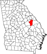
Jefferson County, Georgia Basics:


Jefferson County Georgia - Government Site

Population: 16,460
Area: 526 square miles
County seat: Louisville
Area code(s) in use: 706 478
Time zone: EST
High school graduate or higher: 73.8%
Bachelor's degree or higher: 8.7%
Median household income: $27,612
Persons in poverty: 30.3%
Home ownership rate: 67.5%
Mean travel time to work: 21.9 minutes


Adjacent counties:
Augusta - Richmond  Burke  Emanuel  Glascock  Johnson  McDuffie  Warren  Washington  

Find in Georgia

Map of the Jefferson County area


Our detail map of Jefferson County shows the Jefferson County, Georgia boundary lines and other interesting items.

Places in Jefferson County, Georgia

  Airports     show all on map

Eliott Barrow Airport, Louisville Municipal Airport, Wrens Memorial Airport

  Bends     show all on map

Lower Roundabout, Upper Roundabout

  Bridges     show all on map

Huddens Bridge, Littles Bridge, McCroans Bridge, Patterson Bridge, Rayfords Bridge, Sand Valley Bridge (historical), Ways Bridge

  Buildings     show all on map

Avera Volunteer Fire Department, Bartow Police Department, Bartow Volunteer Fire Department, Hillcrest Volunteer Fire Department, Jefferson County Correctional Institution, Jefferson County Courthouse, Jefferson County Jail, Jefferson County Louisville Station Headquarters, Jefferson County Sheriff's Office, Jefferson County Wrens Substation, Louisville City Hall, Louisville Fire Department, Louisville Police Department, Matthews Community Fire Department, Stapleton Fire Department, Stapleton Police Department, Wadley Police Department, Wadley Volunteer Fire Department, Wrens Fire Department, Wrens Police Department

  Cemeteries     show all on map

Arrington Cemetery, Avera Cemetery, Avret Cemetery, Bartow Cemetery, Beasley Cemetery, Bentley Cemetery, Berryhill Cemetery, Bethlehem Cemetery, Blounts Chapel Cemetery, Boatwright Cemetery, Bothwell Cemetery, Burke Cemetery, Cara Cemetery, Carson Cemetery, Causey Cemetery, Clark Cemetery, Dixon Grove Cemetery, Duhart Cemetery, Ebenezer Cemetery, Ebenezer Cemetery, Ellis Cemetery, Flat Rock Cemetery, Garden Grove Cemetery, Glenn Temple Cemetery, Harts Grove Cemetery, Jones Grove Cemetery, King Cemetery, Little Cemetery, Live Oak Cemetery, Lofton Cemetery, Lofton Cemetery, Magnolia Cemetery, Mays Grove Cemetery, McBride Cemetery, Melton Place Cemetery, Mosley Chapel Cemetery, Mount Horeb Cemetery, Mount Horeb Cemetery, Mount Moriah Cemetery, Nesbitt Cemetery, Oak Grove Cemetery, Old Bethel Cemetery, Parker Cemetery, Patterson Cemetery, Phillips Cemetery, Pierce Grove Cemetery, Pioneer Cemetery, Pleasant Grove Cemetery, Plunkett Cemetery, Ponder Family Cemetery, Providence Cemetery, Smiths Grove Cemetery, Stapleton Cemetery, Stapleton Cemetery, Stone Springfield Cemetery, Street Place Cemetery, Vining Cemetery, Waldens Cemetery, Ways Cemetery, Ways Grove Cemetery, Woodland Cemetery, Wrens Cemetery, Wrens Memorial Cemetery

  Census     show all on map

Matthews Census Designated Place

  Churches     show all on map

Aldred Chapel (historical), Allen Temple Church, Apostolic Church, Avera Church, Avera Nazarene Church, Bethlehem Church, Blounts Chapel Church, Brunson Church, Calvary Temple, Clarks Grove Church (historical), Colemans Chapel, Corinth Church (historical), Dixon Grove Church, Duhart Church, Ebenezer Church, Ebenezer Church, Eden Church, Farmer Grove Church, First Baptist Church, Flat Rock Church, Friendship Church, Gallilee Church, Hardman Springfield Church, Harmony Church, Harts Grove Church, James Temple, Jones Grove Church, Live Oak Church, Lofton Church, Louisville Baptist Church, Magnolia Church, Mays Grove Church, Moses Chapel Church, Mount Horeb Church, Mount Horeb Church, Mount Moriah Church, Mount Olive Church, Mount Pleasant Church, Nails Creek Church, New Hope Church, Oak Grove Church, Old Bethel Church, Old Bethel Church, Parkers Church, Pervis Grove Church, Pierce Grove Church, Pinetucky Church, Pioneer Church, Pleasant Grove Church, Providence Church, Saint Johns Church, Saint Matthews Methodist Episcopal Church, Saint Paul Baptist Church, San Clair Church, Sand Valley Church, Smiths Grove Church, Spell Grove Church, Spring Bethel Church, Stone Springfield Church, Thomason Spring Hill Church, Trinity Church, Union Bethel Church, Waldon Church, Walton Grove Church, Ways Church, Ways Grove Church, Woodland Church, Woodlawn Chapel

  Dams     show all on map

Adams Lake Dam, Battle Pond Dam, Clarks Mill Pond Dam, Cobb Lake Dam, Davis Lake Dam, Easterlin Lake Dam, Evans Lake Dam, Gambrell Lake Dam, Gardner Lake Dam, Haddon Pond Dam, Hancock Lake Dam, Henderson Lake Dam, Huber Lake Dam, Kelly Lake Dam, Kellys Pond Dam, Lake Marion Dam, McNeely Lake Dam, Newberrys Pond Dam, Pennington Lake Dam, Pilcher Lake Dam, Rabun Lake Dam, Rachels Pond Dam, Smith Lake Dam, Smith Lake Dam, Stapleton Millpond Dam, Thomas Lake Dam, Union Camp Corporation Lake Dam, Weeks Lake Dam, Wommack Lake Dam

  Guts     show all on map

Three Runs

  Hospitals     show all on map

Jefferson Hospital

  Lakes     show all on map

Greener Mill Pond, Jones Pond, Oliphant Pond (historical)

  Locales     show all on map

Clarks Mill, Grange, Louisville Golf Club, Mount Moriah Campgrounds, Rhodes Store (historical)

  Populated Places     show all on map

Aldreds, Almira, Atwell, Avera, Bartow, Brinson Crossing, Cunningham Corner, Ellis Plantation, Louisville, Magnolia, Matthews, Moxley, Noah, Old Town, Omaha Springs, Padgett Crossing (historical), Pine Hill, Pinetucky (historical), Stapleton, Stapletons Crossroads, Stellaville, Wadley, Wrens, Wrens Station, Zebina

  Post Offices     show all on map

Bartow Post Office, Louisville Post Office

  Reservoirs     show all on map

Adams Fish Pond, Adams Lake, Battle Pond, Clarks Mill Pond, Cobb Lake, Davis Lake, Easterlin Lake, Evans Lake, Gamble Mill Pond, Gambrell Lake, Gardner Lake, Goodins Pond (historical), Hadden Pond, Haddon Pond, Hancock Lake, Henderson Lake, Huber Lake, James Pond, Kelly Lake, Kellys Pond, Kings Mill Pond, Lake Marion, McNeely Lake, Newberrys Pond, Oliphant Pond (historical), Pennington Lake, Pilcher Lake, Prescott Pond, Rabun Lake, Rachels Pond, Smith Lake, Smith Lake, Stapleton Mill Pond, Stapleton Millpond, Thomas Lake, Union Camp Lake, Weeks Lake, White Pond, Wommack Lake

  Schools     show all on map

Anderson School (historical), Atwell School, Avera Junior High School, Bartow High School, Beckman School (historical), Carver - Wadley Junior High School, Dry Creek School (historical), Farmers Grove School (historical), Field Grove School (historical), Gallilee School, Gamble Mill School (historical), Garden Grove Church and School, Grange Junior High School (historical), Harmony School (historical), Jefferson County Training School (historical), Laurel Hill School (historical), Lewis Grove School (historical), Lockhart School, Lofton School, Logyard School (historical), Louisville District School Number 1 (historical), Louisville High School, Matthews Junior High School, Moxley Junior High School (historical), Munjin School, Noah School (historical), Oak Grove School (historical), Ocala School (historical), Pinetucky School (historical), Pioneer School, Postoak School (historical), Rockydale School (historical), Shady Grove School (historical), Spies Hill School, Spring Bethel School, Stapleton High School, Stapleton School, Stellaville Junior High School, Stone Springfield School, Tarvers Grove School (historical), Thomas Spring Hill School, Tuckahoe School (historical), Wadley High School, Woodland School (historical), Wrens Academy (historical), Wrens Elementary School, Wrens High School, Zebina Junior High School (historical)

  Springs     show all on map

Manson Spring

  Streams     show all on map

Baker Branch, Beaslys Branch, Berrien Branch, Big Creek, Blackjack Branch, Boggy Gut Creek, Bony Branch, Boyd Branch, Bull Nose Branch, Camp Branch, Cason Branch, Clear Creek, Coat Creek, Dry Creek, Duhart Creek, Fishpond Branch, Flat Rock Branch, Fleming Branch, Hadden Branch, Hannah Branch, Hannah Branch, Howard Branch, Ivey Branch, Jim Brown Branch, Johnson Branch, Jordan Branch, Juniper Branch, Lawson Branch, Limestone Creek, Long Branch, Manson Branch, Maple Branch, McQuaddy Branch, Mill Creek, Nails Creek, Nortons Millrace, Rayburn Branch, Reedy Creek, Rock Branch, Rocky Branch, Rocky Comfort Creek, Salter Branch, Savannah Branch, Schaffer Creek, Smith Branch, Spring Creek, Spring Creek, Stephens Branch, Stinson Branch, Whites Creek, Williamson Swamp Creek

  Swamps     show all on map

Gun Pond

  Towers     show all on map

Jefferson Lookout Tower, WCES-TV (Wrens), WPEH-AM (Louisville), WPEH-FM (Louisville), WRDW-FM (Wrens),

Jefferson County, Georgia Population By Race (2012 estimate)

RacePopulation
BlackJefferson County Black population 8,8728,871  
WhiteJefferson County White population 7,3087,308
MixedJefferson County Mixed population 148148
AsianJefferson County Asian population 8282
American IndianJefferson County American Indian population 3332
Hawaiian & Pacific IslanderJefferson County Hawaiian & Pacific Islander population 1616

Additional population tables :
State population table
Georgia population by county