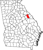
McDuffie County, Georgia Basics:


McDuffie County Georgia - Government Site

Population: 21,650
Area: 257 square miles
County seat: Thomson
Area code(s) in use: 706
Time zone: EST
High school graduate or higher: 75.0%
Bachelor's degree or higher: 13.3%
Median household income: $38,855
Persons in poverty: 20.5%
Home ownership rate: 66.4%
Mean travel time to work: 25.3 minutes


Adjacent counties:
Augusta - Richmond  Columbia  Jefferson  Lincoln  Warren  Wilkes  

Find in Georgia

Map of the McDuffie County area


Our detail map of McDuffie County shows the McDuffie County, Georgia boundary lines and other interesting items.

Places in McDuffie County, Georgia

  Airports     show all on map

Thomson-McDuffie County Airport

  Bends     show all on map

Busseys Bend, Griffins Bend, Raysville Bend, Shaws Bend, Storks Bend

  Bridges     show all on map

Huff Bridge, Luckie Bridge, Raysville Bridge, Smith Bridge (historical), Tom Watson Bridge, Woodruff Bridge

  Buildings     show all on map

Dearing Fire Department, Georgia State Patrol Thomson, McDuffie County Courthouse, McDuffie County Fire Department -Headquarters, McDuffie County Fire Department Station 2, McDuffie County Fire Department Station 3, McDuffie County Fire Department Station 4, McDuffie County Fire Department Station 5, McDuffie County Fire Department Station 6, McDuffie County Jail, McDuffie County Sheriff's Office, McDuffie County Sheriff's Office Substation, Thomson City Hall, Thomson Fire Department, Thomson Fire Department Station 2, Thomson Police Department, Thomson-McDuffie County Library

  Cemeteries     show all on map

Adams Cemetery, Adams Cemetery, Adams Chapel Cemetery, Barksdale-Story-Bradshaw Cemetery, Collins Cemetery, Dearing Cemetery, Fort Creek Cemetery, Foster Cemetery, Griffin-Johnson Cemetery, Hardaway Cemetery, Hughes Cemetery, Iron Hill Cemetery, Ivey Cemetery, Ivory Family Cemetery, Johnson Cemetery, Jones Grove Cemetery, Liberty Hill Cemetery, Marshall Cemetery, Moore Cemetery, Mount Pleasant Cemetery, Neal Cemetery, New Hope Cemetery, New Zion Hill Cemetery, Old Griffin Cemetery, Paul Cemetery, Phillips Cemetery, Pine Grove Cemetery, Piney Grove Cemetery, Pleasant Grove Cemetery, Poplar Head Cemetery, Printup Cemetery, Rees-Wade-Short Cemetery, Reeves Cemetery, Reeves Cemetery, Saint Luke Cemetery, Salem Cemetery, Savannah Valley Memorial Garden, Silver Run Cemetery, Smith Cemetery, Smith Cemetery, Society Cemetery, Springfield Cemetery, Story Cemetery, Sweetwater Cemetery, Thomson City Cemetery, Union Cemetery, Walker Cemetery, Walker Cemetery, Watson Family Cemetery, Westview Cemetery, Wrightsboro Cemetery

  Churches     show all on map

Adams Chapel Church, Boneville Methodist Church, Brinkley Chapel, Calvary Church, Dearing Baptist Church, Dearing Methodist Church, First Methodist Church, Fort Creek Church, Friendship Church, Green Branch Church, House of Prayer Church, Iron Hill Church, Jones Grove Church, Kingdom Hall Church, Langston Grove Church, Liberty Hill Church (historical), Marshall Church, Mount Gilead Church, Mount Pleasant Church, New Zion Hill Church, Norris Chapel, Pine Grove Church, Piney Grove Church, Pleasant Grove Church, Poplar Head Church and School, Queen of Angels Church, Rodgers Church (historical), Saint Luke Church, Salem Church, Silver Run Church, Sweetwater Church, Union Church, Washington Heights Church, White Oak Grove Church, Wrightsboro Methodist Church

  Crossings     show all on map

Exit 59, Exit 60

  Dams     show all on map

Arties Pond Dam, Boneville Pond Dam, Bowdens Pond Dam Number One, Bowdens Pond Dam Number Two, Dearing Number 10 Lake Dam, Dearing Number 11 Lake Dam, Dearing Number 12 Lake Dam, Dearing Number 13 Lake Dam, Dearing Number Nine Lake Dam, Dearing Number Six Lake Dam, Harrison Lake B Dam, Harrison Lake Dam, Howard Lake Dam, Johnson Dam, Johnson Pond Dam, Knox Lake Dam, McNeil Dam, Simons Pond Dam, Usry Pond Dam

  Hospitals     show all on map

McDuffie Regional Medical Center

  Locales     show all on map

Arrington Mill (historical), Belle Meade Country Club, Dyers Mill (historical), Hobbs Mill (historical), Honeys Old Mill (historical), Smiths Mill (historical), Sweet Water Mill (historical), Thomson Country Club, Willingham Mill (historical)

  Parks     show all on map

McDuffie Public Fishing Area, Thomson Commercial Historic District

  Populated Places     show all on map

Adamsville, Ansley Mill, Anthony Crossroads, Autney, Avondale, Boneville, Cobbham, Cobbham Crossroads, Columbia Mine (historical), Dearing, Hamilton Crossroads, Happy Valley, Megahee, Raysville, Rousseau Spring (historical), Scuffletown, Shiloh (historical), Stones Crossroads, Tatham Mines (historical), Thomson, Three Points, Wrightsboro

  Post Offices     show all on map

Thomson Post Office

  Reservoirs     show all on map

Arringtons Pond, Arties Pond, Boatwright Pond, Boneville Pond, Bowdens Pond, Bowdens Pond Number One, Bowdens Pond Number Two, Bradshaw Lake, Dearing Number 10 Lake, Dearing Number 11 Lake, Dearing Number 12 Lake, Dearing Number 13 Lake, Dearing Number Nine Lake, Dearing Number Six Lake, Harrison Lake A, Harrison Lake B, Hobbs Pond, Howard Lake, Johnson Lake, Johnson Pond, Knox Lake, Lokeys Pond, Lokeys Pond, Magahee Ponds, McNeil Pond, Shields Pond, Simons Pond, Usry Pond

  Schools     show all on map

Adams School (historical), Boydsville High School (historical), Dearing Elementary School, Farr School, Fort Creek School (historical), Harrison School (historical), Headstall School, Holly Grove School (historical), Jones School, Liberty Hill School (historical), Marshall School (historical), Maxwell Elementary School, Mount Gilead School, Mount Pleasant School (historical), Pine Street School, Piney Grove School (historical), R L Norris Elementary School, Redoak School (historical), Reeves School (historical), Republican School (historical), Saint Luke School, Sweetwater School (historical), Thomson Elementary School, Thomson High School, Thomson McDuffie Junior High School, Thomson Middle School

  Streams     show all on map

Big Creek, Black Branch, Boggy Gut Creek, Boneville Stream, Broom Creek, Cowhide Branch, Danley Branch, Dearing Branch, Dry Branch, Dry Branch, Factory Creek, Fort Creek, Germany Creek, Gin Branch, Hard Fortune Creek, Hart Creek, Headstall Creek, Jimmerson Branch, Little Creek, Little Germany Creek, Mangy Branch, Mattox Creek, Mollie Branch, Pegaham Branch, Rousseau Creek, Sills Branch, Sweetwater Creek, Todds Branch, Whites Creek

  Towers     show all on map

WTHO-FM (Thomson), WTWA-AM (Thomson),

McDuffie County, Georgia Population By Race (2012 estimate)

RacePopulation
WhiteMcDuffie County White population 12,36212,362  
BlackMcDuffie County Black population 8,7908,789
MixedMcDuffie County Mixed population 303303
American IndianMcDuffie County American Indian population 8786
Hawaiian & Pacific IslanderMcDuffie County Hawaiian & Pacific Islander population 2221

Additional population tables :
State population table
Georgia population by county