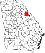
Wilkes County, Georgia Basics:


Wilkes County Georgia - Government Site

Population: 10,060
Area: 469 square miles
County seat: Washington
Area code(s) in use: 706
Time zone: EST
High school graduate or higher: 75.0%
Bachelor's degree or higher: 13.8%
Median household income: $28,224
Persons in poverty: 28.8%
Home ownership rate: 69.9%
Mean travel time to work: 24.8 minutes


Adjacent counties:
Elbert  Lincoln  McDuffie  Oglethorpe  Taliaferro  Warren  

Find in Georgia

Map of the Wilkes County area


Our detail map of Wilkes County shows the Wilkes County, Georgia boundary lines and other interesting items.

Places in Wilkes County, Georgia

  Airports     show all on map

Great Oaks Airport, Washington-Wilkes County Airport

  Bars     show all on map

Anthony Shoals

  Bends     show all on map

Fish Dam Bend

  Bridges     show all on map

Bells Bridge

  Buildings     show all on map

Danburg Volunteer Fire Department, Georgia State Patrol Troop E Post 17 Washington, Jackson Cross Roads Fire Department, Mary Willis Library, Metasville Fire Department, Newtown Fire Department, Rayle Fire Department, Robert Toombs House, Rocky Creek Fire Department, Serenity Behavioral Health Systems, Tignall Fire Department, Tignall Police Department, Tyrone Volunteer Fire Department, Washington City Hall, Washington Fire Department, Washington Police Department, Washington-Wilkes Historical Museum, Wilkes County Courthouse, Wilkes County Jail, Wilkes County Sheriff's Office, Wilkes Pre-Release Center

  Cemeteries     show all on map

Beaverdam Cemetery, Bethel Cemetery, Burdette Cemetery, Clarks Station Cemetery, Cliffords Grove Cemetery, Danburg Cemetery, Ebenezer Cemetery, Fishing Creek Cemetery, Friendship Cemetery, Mallorysville Cemetery, Mount Zion Cemetery, Newtown Cemetery, Phillips Mill Cemetery, Pierces Chapel Cemetery, Popes Chapel Cemetery, Rock Cemetery, Saint Johns Cemetery, Sardis Cemetery, Simpson Cemetery, Symrna Cemetery, Tabor Cemetery, Tignall Cemetery

  Churches     show all on map

Beaverdam Church, Bethel Church, Bethlehem Church, Cherry Grove Church, Clark Station Church, Clifford Grove Church, Cliffords Grove Church, Danburg Church, Ebenezer Church, First Baptist Church, First United Methodist Church, Fishing Creek Church, Flint Hill Church, Friendship Church, Gipson Church, Heards Chapel, Hilliard Station Church, Hills Chapel (historical), Jackson Chapel African Methodist Episcopal Church, Jones Chapel, Kingdom Hall Church, Lyonsville Church, Macedonia Church, Mallorysville Church, Metasville Church, Mount Carmel Baptist Church, Mount Nebo Church, Mount Pleasant Church, Mount Zion Church, Mulberry Church, New Hope Church, New Salem Church, New Town Church, Newford Church, Phillips Mill Church, Pierces Chapel, Pleasant Grove Church, Pompeye Chapel, Popes Chapel, Popes Chapel African Methodist Episcopal Church (historical), Reeves Chapel, Rock Church, Rocky Mount Church, Saint James Methodist Church (historical), Sardis Church, Shady Grove Church, Shiloh Church, Smyrna Church, Tabernacle Baptist Church, Tabor Church, The Church of the Mediator, Trinity Church, Twin Oaks Church, Victory Church, Victory Church, Washington Presbyterian Church, White Rock Church, Wilkes County Church, Wilson Chapel Presbyterian Church, Youngs Chapel, Zion Church

  Crossings     show all on map

Fish Dam Ford (historical)

  Dams     show all on map

Beaverdam Creek Dam, Booth Lake Dam, Burdette-Harris Dam Number One, City of Washington Reservoir Dam, Garrard Dam, Grimaude Lake Dam, Hale Lake Dam, Harris-Burdette Dam Two, Norman Lake Dam, Palmer Lake Dam, Shillinglaw Lake Dam, Washington Country Club Lake Dam, Washinton-Wilkes Orchard Dam

  Hospitals     show all on map

Washington General Hospital (historical), Wills Memorial Hospital

  Islands     show all on map

Green Island

  Locales     show all on map

Bi-Lo Plaza Shopping Center, Court Ground, Jacksons Store, Kettle Creek Battlefield, Mallorysville, Washington Country Club

  Mines     show all on map

Fairy Ridge Mine, Stony Ridge Mine

  Parks     show all on map

Fishing Creek Public Hunting Area, Holliday Park, Ranger Stadium, Tiger Stadium, War Hill Monument

  Populated Places     show all on map

Adasburg, Anne Heights, Aonia, Armstrong (historical), Bessie (historical), Brickhouse, Broad, Callaway, Celeste, Centerville, Chatfield (historical), Cohentown, Danburg, Daniel, Delhi, Dyson (historical), Ficklin, Floral Hill, Jackson Heights, Jacksons Crossroads, Lina (historical), Lincoln Heights, Linesville, Little River, Logan, Lundberg, Metasville, New Town, Norman, Oak Grove, Porters, Possie (historical), Prather, Ravenwood Park, Rayle, Sandtown, Sandy Hill, Thaxton (historical), Tignall, Tyrone, Washington, Washington Heights

  Post Offices     show all on map

Washington Post Office

  Reservoirs     show all on map

Beaverdam Creek Lake, Booth Lake, Burdette-Harris Lake Number One, City of Washington Reservoir, Garrard Lake, Grimaude Lake, Hale Lake, Harris-Burdette Lake Two, Johnson Pond, Norman Lake, Palmer Lake, Shillinglaw Lake, Washington Country Club Lake, Washington-Wilkes Orchard Lake

  Schools     show all on map

Cherry Grove School, Danburg Female Institute (historical), Danburg School, Hoggs High School (historical), Mallorysville Academy (historical), Metasville High School, Mount Nebo School, Mulberry School, Pole Branch School, Reeves Chapel School, Rocky Mount Academy (historical), Rosenwald High School, Saint Johns School, Salem Academy (historical), Stony Ridge School (historical), Succoth Academy (historical), Washington - Wilkes Elementary School, Washington - Wilkes High School, Washington - Wilkes Middle School, Washington - Wilkes Primary School, Washington Academy (historical), Washington Public School (historical), Wilkes Academy

  Streams     show all on map

Anderson Mill Creek, Armstrong Branch, Beaverdam Creek, Beaverdam Creek, Beck Branch, Benson Branch, Brickhouse Branch, Carlton Branch, Cedar Creek, Centerville Branch, Chapel Branch, Chickasaw Creek, Clark Creek, Dry Fork Creek, Greensboro Branch, Harden Creek, Hatchet Branch, Hog Fork, Hood Branch, Hutton Creek, Jocko Creek, Jordan Branch, Kary Wood Branch, Kemp Creek, Kettle Creek, Linesville Branch, Little Beaverdam Creek, Little Kettle Creek, Lunceford Branch, Middle Creek, Mill Branch, Moore Branch, Morris Creek, Pole Branch, Porters Branch, Rehoboth Branch, Rock Creek, Rocky Creek, Sardis Branch, Sims Ditch, Susan Smith Branch, Tanyard Branch, Threemile Creek, Upton Creek, Ware Branch, Williamson Branch, Wolf Branch, Wynn Creek

  Summits     show all on map

War Hill

  Towers     show all on map

WLOV-AM (Washington), WLOV-FM (Washington),

Wilkes County, Georgia Population By Race (2012 estimate)

RacePopulation
WhiteWilkes County White population 5,5735,573  
BlackWilkes County Black population 4,2454,245
MixedWilkes County Mixed population 151150
AsianWilkes County Asian population 7070
American IndianWilkes County American Indian population 2020
Hawaiian & Pacific IslanderWilkes County Hawaiian & Pacific Islander population 00

Additional population tables :
State population table
Georgia population by county