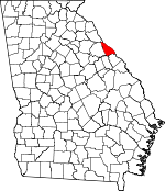
Lincoln County, Georgia Basics:


Lincoln County Georgia - Government Site

Population: 7,770
Area: 210 square miles
County seat: Lincolnton
Area code(s) in use: 706
Time zone: EST
High school graduate or higher: 81.5%
Bachelor's degree or higher: 11.4%
Median household income: $34,347
Persons in poverty: 25.9%
Home ownership rate: 80.9%
Mean travel time to work: 32.7 minutes


Adjacent counties:
Columbia  Elbert  McCormick (SC)  McDuffie  Wilkes  

Find in Georgia

Map of the Lincoln County area


Our detail map of Lincoln County shows the Lincoln County, Georgia boundary lines and other interesting items.

Places in Lincoln County, Georgia

  Airports     show all on map

New Prater Ranch Airport, Prater Ranch Airport, Prater Ranch Airport

  Bridges     show all on map

Fortsons Ferry Bridge

  Buildings     show all on map

Beulah Volunteer Fire Department, Lincoln County Courthouse, Lincoln County Jail, Lincoln County Sheriff's Department, Lincolnton Police Department, Lincolnton Volunteer Fire Department, Loco Volunteer Fire Department, Martins Crossroad Volunteer Fire Department, Martins Crossroad Volunteer Fire Department Station 2, Midway Volunteer Fire Department

  Capes     show all on map

Bussey Point

  Cemeteries     show all on map

Anthonys Chapel Cemetery, Crook Cemetery, Estes Cemetery, Goshen Cemetery, Greenwood Cemetery, Hogan Cemetery, Lincolnton Cemetery, Midway Cemetery, Saint Pauls Methodist Church Cemetery, Smith Chapel Cemetery

  Churches     show all on map

Anthony Church, Antioch Church, Arimathea Church (historical), Bethany Church, Beulah Church, Double Branches Church, Ebenezer Church, Goshen Church, Greenwood Church, Harmony Church, Hepzibah Church, Holiness Church, Lincolnton Presbyterian Church, Loco Church, Loco Holiness Church, Midway Church, Mount Zion Church, Mulberry Church, New Hope Baptist Church, New Tabernacle Baptist Church, Newberry Church, Parks Grove Church, Pine Grove Church, Pleasant Grove Church, Price Grove Church, Rock Hill Methodist Church (historical), Saint Lukes Church, Saint Pauls Church, Salem Baptist Church, Smith Chapel, Tabernacle Church, Thankful Church, White Rock Church

  Crossings     show all on map

Barksdale Ferry (historical), Busseys Ferry (historical), Chamberlains Ferry (historical), Fortsons Ferry (historical), Gilchrist Ferry (historical), Hesters Ferry (historical), Leroys Ferry (historical), McCoys Ferry (historical), Paces Ferry (historical), Remsens Ferry (historical), Scotts Ferry (historical), Sturkeys Ferry (historical)

  Dams     show all on map

Forest Lake Estates Dam

  Islands     show all on map

Ferguson Island (historical), Martin Island (historical), Murry Island (historical), Price Island (historical), Price Island (historical), Searle Island (historical)

  Locales     show all on map

Augusta Camp, Cade Mill (historical), Camp Daniel Marshall, Lincolnton Waterworks, Murry Creek Camping Area, Soap Creek Lodge

  Mines     show all on map

Magruda Mines

  Parks     show all on map

Elijah Clark Monument, Elijah Clark State Park

  Populated Places     show all on map

Agnes (historical), Amity, Beulah, Bussey, Chennault, Clay Hill, Curry Hill, Double Branches, Gill, Goshen, Graball, Honora, Leathersville, Leverett, Lincolnton, Lisbon, Loce, Lovelace, Martins Crossroads, Maxim, Midway, New Hope, Salem (historical), Sybert, White Rock (historical), Woodlawn

  Reservoirs     show all on map

Forest Lake

  Schools     show all on map

Agnes School (historical), Clay Hill School (historical), Ebenezer School, Harmony School, Jones Academy (historical), Liberty Hill School (historical), Liberty School (historical), Lincoln County Elementary School, Lincoln County High School, Lincoln County Middle School, Lincolnton Academy (historical), Lockhart School (historical), Martins Academy (historical), New Tabernacle School, Newberry School (historical), Woodlawn School (historical), Zion School (historical)

  Springs     show all on map

Dooley Spring

  Streams     show all on map

Beach Branch, Camp Creek, Cherokee Creek, Curry Creek, Double Branches, Dozier Branch, Dry Fork Creek, Fishing Creek, Florence Creek, Gold Mine Branch, Goshen Branch, Grays Creek, Gualett Branch, Hamburg Branch, Jerry Branch, Knoblick Branch, Little Creek, Lloyd Creek, Mill Creek, Mine Branch, Murry Creek, Newford Creek, Pistol Creek, Shriver Creek, Soap Creek, Wells Creek

  Summits     show all on map

Graves Mountain,

Lincoln County, Georgia Population By Race (2012 estimate)

RacePopulation
WhiteLincoln County White population 5,1365,135  
BlackLincoln County Black population 2,4942,494
MixedLincoln County Mixed population 7877
AsianLincoln County Asian population 3131
American IndianLincoln County American Indian population 2323
Hawaiian & Pacific IslanderLincoln County Hawaiian & Pacific Islander population 00

Additional population tables :
State population table
Georgia population by county