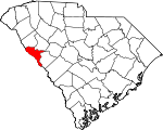
McCormick County, South Carolina Basics:


McCormick County South Carolina - Government Site

Population: 9,976
Area: 359 square miles
County seat: McCormick
Area code(s) in use: 864
Time zone: EST
High school graduate or higher: 78.0%
Bachelor's degree or higher: 18.6%
Median household income: $38,385
Persons in poverty: 14.1%
Home ownership rate: 78.7%
Mean travel time to work: 28.3 minutes


Adjacent counties:
Abbeville  Columbia (GA)  Edgefield  Elbert (GA)  Greenwood  Lincoln (GA)  

Find in South Carolina

Map of the McCormick County area


Our detail map of McCormick County shows the McCormick County, South Carolina boundary lines and other interesting items.

Places in McCormick County, South Carolina

  Airports     show all on map

Mc Cormick County Airport, McCormick Airport

  Bays     show all on map

Howell Branch, Scott Creek

  Bends     show all on map

Big Bottom

  Bridges     show all on map

Bradley Bridge, Fortson Ferry Bridge, Furys Ferry Bridge, Key Bridge, Long Cane Bridge, Mars Bridge, Mill Bridge, Morrow Bridge, Patterson Bridge (historical)

  Buildings     show all on map

Clarks Hill - Lost Wilderness Fire Department, Little River Volunteer Fire Department, McCormick Correctional Institution, McCormick County Emergency Medical Services, Modoc Volunteer Fire Department, Parksville Volunteer Fire Department, Plum Branch Volunteer Fire Department, Sandy Branch Volunteer Fire Department, Town of McCormick Volunteer Fire Department

  Cemeteries     show all on map

Ashbury Cemetery, Badwell Cemetery, Bethany Cemetery, Bethelehem Cemetery, Bordeaux Cemetery, Boyd Cemetery, Brough Cemetery, Buffalo Cemetery, Canfield Cemetery, Chapel Cemetery, Chisholm Cemetery, De La Howe Tomb, Hopewell Cemetery, Hopewell Cemetery, Hopewell Cemetery, Indian Massacre Grave, Jones Cemetery, Lower Long Cane Cemetery, McCormick City Cemetery, McKie Cemetery, Middleton Cemetery, Modoc Cemetery, Mount Carmel Cemetery, Mount Vernon Cemetery, New Hope Cemetery, Old Bethany Cemetery, Old Rohoboth Cemetery, Overbrook Cemetery, Parksville Cemetery, Pine Grove Cemetery, Plum Branch Cemetery, Republican Cemetery, Rohoboth Cemetery, Wideman Cemetery, Wideman-Harris-Wilks Cemetery, Willington Cemetery

  Census     show all on map

Clarks Hill Census Designated Place, Modoc Census Designated Place, Mount Carmel Census Designated Place, Willington Census Designated Place

  Churches     show all on map

Asbury Mission Church, Bailey Bethel Church, Bethany Church, Bethany Church, Bethlehem Church, Bold Spring Church (historical), Bordeaux Church, Buffalo Baptist Church, Callihams Mill Church (historical), Candys Chapel, Cedar Springs Church, Edney Chapel, First Baptist Church, Glover Chapel, Green Olive Church, Harpers Chapel, Holy Rock Church, Holy Spring Church, Hopewell Baptist Church, Hosannah Church, Hosannah Church, Laura Chapel (historical), Laurel Grove Church, Little Mill Church, Long Cane Church, Marthas Chapel (historical), McAllister Chapel, McCormick United Methodist Church, McKissick Memorial Chapel, Modoc Baptist Church, Mount Lebanon Church, Mount Moriah Church, Mount Moriah Church, Mount Pleasant Church, Mount Vernon Church, Mount Zion Church, New Bordeaux Church, New Hope Church, Oak Grove Church (historical), Old Whitetown Church (historical), Old Willington Church (historical), Parksville Baptist Church, Parksville Methodist Church, Pine Grove Church, Pine Grove Church (historical), Plum Branch Baptist Church, Rehoboth Church, Republican Church, Robinson Church (historical), Rock Ford Church, Rocky Creek Church (historical), Saint Charlottes Church, Saint Marys Church, Saint Paul Church, Shiloh Church, Spring Grove Church, Springfield Church, Springfield Church, Tranquil Church, White Rock Church, Willing Church (historical), Willington Presbyterian Church, Zion Chapel, Zion Chapel (historical)

  Crossings     show all on map

Barksdale Ferry (historical), Busseys Ferry (historical), Cades Ferry (historical), Chamberlains Ferry (historical), Dents Ferry (historical), Fortsons Ferry (historical), Furys Ferry (historical), Gilchrist Ferry (historical), Hesters Ferry (historical), Leroys Ferry (historical), McCoys Ferry (historical), Middletons Ferry (historical), Morrahs Ferry (historical), Paces Ferry (historical), Remsens Ferry (historical), Scotts Ferry (historical), Sturkeys Ferry (historical)

  Dams     show all on map

South Carolina Noname 35001 D-0642 Dam, South Carolina Noname 35003 D-0641 Dam, South Carolina Noname 35005 D-0640 Dam, South Carolina Noname 35006 D-0639 Dam, South Carolina Noname 35007 D-0638 Dam, South Carolina Noname 35008 D-0637 Dam

  Forests     show all on map

Sumter National Forest

  Guts     show all on map

Linkay Creek

  Hospitals     show all on map

McCormick Correctional Institution Infirmary

  Locales     show all on map

Byrd Creek Rifle Range, Cedar Springs Rifle Range, Civilian Conservation Corps Camp F-11 (historical), Clark Hill Marina, Clark Hill Powerhouse, Hamilton Brach Campground, Hamilton Branch Campground, Harvey Mill (historical), Hawe Creek Camping Area, Johnsons Spur (historical), Key Bridge Hunt Camp, Little River Quarry Boat Ramp, Long Cane Creek Boat Ramp, Long Crane Creek Campground, McCormick County Fairground, Modoc Camp Area, Monroe Ridge Hunt Campground, Mount Carmel Campground, Prices Mill, Searle Mill (historical), Shinburg Mill (historical), Upper Price Mill (historical), Wallace Landing (historical), Willow Landing (historical), Woodlawn Station

  Mines     show all on map

Dorn Gold Mine, Little River Quarry, Pioneer Gold Mine

  Parks     show all on map

Baker Creek State Park, Below Dam Recreation Area, Buffalo Creek Recreation Area, Chamberlain Ferry Picnic Area, Clarks Hill Recreation Area, Hamilton Branch State Park, Hickory Knob State Park, Hickory Knob State Park, Leroys Ferry Recreation Area, Long Cane Creek Picnic Area, Mount Carmel Historic District, Mount Carmel Park, Parksville Recreation Area, Parksville Wayside Park, Patterson Branch Picnic Area

  Populated Places     show all on map

Belcher Crossroads, Bethany (historical), Bordeaux, Bradley Corner, Buffalo, Calhoun Mill, Cedar Hill, Clarks Hill, Dornville (historical), Hickory Knob Subdivision, Lethia, Liberty Hill, Little River Subdivision, McCormick, Meriwether, Modoc, Modoc Subdivision, Mount Carmel, Parks Mill, Parksville, Plum Branch, Whites Cross Roads (historical), Whitetown, Willington, Winterseat, Woodlawn

  Reservoirs     show all on map

Old McCormick Town Reservoir

  Schools     show all on map

Bailey Bethel School (historical), Bethany School (historical), Bethany School (historical), Blue Branch School (historical), Bold Branch School (historical), Bordeaux School (historical), Boyds Chapel School (historical), Branch School (historical), Buffalo School (historical), Cedar Springs School (historical), Chapel School (historical), Chesnut Ridge School (historical), De La Howe State School, Geyer Springs School (historical), Gibert Rosenwald School (historical), Green Olive School (historical), Green Olive School (historical), Hibler School (historical), Holy Springs School (historical), Hopewell Rosenwald School (historical), Hosannah School (historical), Laurel Grove School (historical), Little Mill School (historical), Long Cane Academy, Lyon School (historical), Marthas Chapel School (historical), McCormick Elementary School, McCormick Middle School, Mims High School, Mims School Number 2, Mims School Number 3, Mount Lebanon School (historical), Mount Moriah School (historical), Mount Moriah School (historical), Mount Pleasant School (historical), Mount Zion School (historical), Mulberry School (historical), Pine Grove School (historical), Piney Grove School (historical), Ritchentown School (historical), Robinson School (historical), Rock Grove School (historical), Rock Hill School (historical), Saint Charlotte School (historical), Saint Marys School, Saint Pauls School, Sand Hill School (historical), Searles School (historical), Springfield School (historical), Whitetown School (historical), Wideman School (historical), Wideman School (historical), Willington Academy (historical), Willington School (historical), Youngs School (historical), Zion Chapel School (historical)

  Streams     show all on map

Baker Creek, Bee Tree Branch, Bell Creek, Benningsfield Creek, Big Branch, Blue Branch, Bold Branch, Bowie Branch, Bracknell Branch, Buffalo Creek, Buncombe Branch, Buzzard Branch, Buzzard Branch, Byrd Creek, Calabash Branch, Chapel Branch, Church Branch, Clay Branch, Coffer Creek, Cole Branch, Conner Creek, Coon Creek, Cosey Branch, Cuffytown Creek, Deal Branch, Deep Step Creek, Doctors Branch, Dordon Creek, Double Branches, Engevine Branch, Flat Branch, Goatneck Branch, Goff Branch, Gold Branch, Hard Labor Creek, Harman Branch, Hartzog Branch, Hawe Creek, Hibbler Branch, Hill Branch, Horse Branch, Horton Branch, Jester Branch, John Branch, Key Branch, Landam Branch, Lee Creek, Lees Branch, Lick Creek, Little Persimmon Branch, Little River, Long Cane Creek, Lott Creek, Ludlow Branch, Mack Branch, Mathis Creek, Mill Branch, Mill Branch, Mill Creek, Morrah Branch, Nixon Branch, Patterson Creek, Patterson Creek, Persimmon Branch, Persimmon Branch, Reedy Branch, Reese Branch, Rocky Branch, Rocky Creek, Russells Creek, Ryan Branch, Sand Branch, Sawney Creek, Scott Creek, Shumate Branch, Tanyard Branch, Taylor Branch, Turkey Creek, Vall Branch, Welch Creek, Wiley Branch, Wilson Spring Creek, Wine Creek

  Summits     show all on map

Laurel Hill

  Towers     show all on map

McCormick Lookout Tower, Woodlawn Lookout Tower

  Trails     show all on map

Turkey Creek Hiking Trail,

McCormick County, South Carolina Population By Race (2012 estimate)

RacePopulation
BlackMcCormick County Black population 4,9584,958  
WhiteMcCormick County White population 4,8684,868
MixedMcCormick County Mixed population 10099
AsianMcCormick County Asian population 3029
American IndianMcCormick County American Indian population 2019
Hawaiian & Pacific IslanderMcCormick County Hawaiian & Pacific Islander population 109

Additional population tables :
State population table
South Carolina population by county