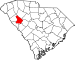
Greenwood County, South Carolina Basics:


Greenwood County South Carolina - Government Site

Population: 69,800
Area: 455 square miles
County seat: Greenwood
Area code(s) in use: 864
Time zone: EST
High school graduate or higher: 79.4%
Bachelor's degree or higher: 21.8%
Median household income: $37,911
Persons in poverty: 20.7%
Home ownership rate: 67.2%
Mean travel time to work: 20.5 minutes


Adjacent counties:
Abbeville  Edgefield  Laurens  McCormick  Newberry  Saluda  

Find in South Carolina

Map of the Greenwood County area


Our detail map of Greenwood County shows the Greenwood County, South Carolina boundary lines and other interesting items.

Places in Greenwood County, South Carolina

  Airports     show all on map

Greenwood County Airport

  Bridges     show all on map

Boyds Bridge, Cothran Bridge, Smith Bridge (historical)

  Buildings     show all on map

Abbeville-Greenwood Regional Library, Callison Volunteer Fire Department, Coronaca Volunteer Fire Department Station 1, Coronaca Volunteer Fire Department Station 2, Epworth - Phoenix Volunteer Fire Department Station 70, Greenwood City Fire Department Station 1, Greenwood City Fire Department Station 2, Greenwood City Fire Department Station 3, Greenwood County Courthouse, Greenwood County Emergency Medical Services, Greenwood County Jail, Greenwood Nursing Center, Greenwood Police Department, Highway 34 Volunteer Fire Department Station 75, Hodges - Cokesbury Fire Department Station 40, Hodges Police Department, Leath Correctional Institution, Long Cane Ranger District Office, Lower Lake Greenwood Fire Station, Lower Lake Greenwood Fire Station 60, Maxwell Childrens Home, McKissick Memorial Library, Ninety - Six Fire Department Station 80, Ninety Six Police Department, Northwest Volunteer Fire Department Station 1, Northwest Volunteer Fire Department Station 2, Old Rock House, Promised Land Fire Department Station 20, South Carolina Highway Patrol Troop 2 Post B, Sproles Recreational Center, Tri - County Volunteer Fire Department Station 95, Troy Fire Department Station 10, United States Forest Service Bradley Work Center, Ware Shoals Fire Department Station 45, Ware Shoals Police Department

  Cemeteries     show all on map

Andrews Cemeteries, Bethlehem Cemetery, Cedar Grove Cemetery, Crossroads Cemetery, Dunns Creek Cemetery, Edgewood Cemetery, Fairview Cemetery, Friendship Cemetery, Greenwood Memorial Gardens, Hillcrest Cemetery, Lyon-Lipford Cemetery, Magnolia Cemetery, Mathews Cemetery, Morris Hill Cemetery, Mount Pleasant Cemetery, Mount Sinai Cemetery, Old Pine Grove Cemetery, Old Tabernacle Cemetery, Penn Cemetery, Rushville Cemetery, Save All Cemetery

  Census     show all on map

Bradley Census Designated Place, Cokesbury Census Designated Place, Coronaca Census Designated Place, Promised Land Census Designated Place

  Churches     show all on map

Abney Missionary Baptist Church, Andrew Chapel Methodist Church (historical), Andrews Chapel, Antioch Church, Bethel Church, Bethel Church, Bethel Church, Bethlehem Baptist Church, Bethlehem Church, Beulah Church, Bold Spring Church, Callie Self Memorial Baptist Church, Calvary Church, Calvary Church, Cambridge United Methodist Church, Cedar Grove Church (historical), Cedar Spring Associate Reformed Presbyterian Church, Church of Christ, Church of God, Cokesbury Baptist Church, Connie Maxwell Baptist Church, Cooper Church (historical), Coronaca Baptist Church, Cross Roads Church (historical), Crossroads Church, Damascus Church, Damascus Church, Dunham Temple Christian Methodist Episcopal Church, Dunns Creek Church, Durst Avenue Church of God, East Side Church, Ebenezer Church (historical), Emanuel Church, Enoree Zion Church, Episcopal Church of the Resurrection, Fellowship Church (historical), First Assembly of God Church, First Associate Reformed Presbyterian Church, First Baptist Church, First Baptist Church of Ninety Six, First Mount Moriah Church, First Presbyterian Church, First Presbyterian Church, Flint Hill Church, Friendship Church, Friendship Church, Galloway Memorial United Methodist Church, Good Hope Church, Greenville Presbyterian Church, Harris Baptist Church, Harris United Methodist Church, Holiness Church (historical), Holy Redeemer Pentecostal Holiness Church, Holy Spring Church, Horeb Church, Hype Park Baptist Church, Immanuel Lutheran Church, Jacobs Chapel, Jordan Street Church, Kinard Chapel, Lakeside Church, Lakeview Church, Laurel Church, Leith Church (historical), Little Blue Church, Little Zion Church, Lowell Street United Methodist Church, Lupo Memorial United Methodist Church, Macedonia Baptist Church, Macedonia Church, Main Street United Methodist Church, Mars Hill Church, Marshall Chapel, Mathews United Methodist Church, Mays United Methodist Church, Millway Church, Morris Chapel Baptist Church, Mount Carmel Church, Mount Carmel Church, Mount Harmony Church, Mount Lebanon Church, Mount Moriah Church, Mount Olive Church, Mount Pisgah African Methodist Episcopal Church, Mount Pisgah Church, Mount Sinai Church, Mount Tabor Church, Mount Zion Church, Mount Zion Church, Mount Zion Church, Mountain Creek Church, Mountain Creek Church (historical), New China Church, New Jerusalem Deliverance Temple, New Market Baptist Church, New Zion Church, Ninety Six Church of God, Ninety Six Pentecostal Holiness Church, North Side Baptist Church, Oak Grove Church, Old Mount Zion Church, Our Lady of Lourdes Catholic Church, Panola Methodist Church, Pentecostal Mission (historical), Pine Grove Church, Pine Grove Church, Pine Pleasant Church, Pleasant Rock Church, Rehoboth Church, Rice Memorial Church, Rock Presbyterian Church, Rose of Sharon Church, Saint Mark United Methodist Church, Saint Marys Roman Catholic Church, Saint Paul Pentescostal Holiness Church, Saint Pauls Church, Salem Church, Sand Ridge Church, Siloam Church, Sinai Church (historical), South Greenwood Church of God, South Greenwood Pentecostal Holiness Church, South Main Street Baptist Church, Springfield Church, Tabernacle Baptist Church, Tabernacle Church (historical), Temple Church, Tranquil Church, Trinity Church (historical), Trinity United Methodist Church, United House of Prayer (historical), Walnut Grove Church, Ware Shoals First Baptist Church, Ware Shoals Pentecostal Holiness Church, Ware Shoals United Methodist Church, Wesley Chapel (historical), Wesleyan Methodist Church (historical), West Main Church of God, West Side Baptist Church, Weston Chapel African Methodist Episcopal Church, Whitehall Church, Woodfields Baptist Church, Woodlawn Church, Youngs Chapel

  Crossings     show all on map

Anderson Ferry (historical), Old Puckett Ferry (historical)

  Dams     show all on map

Metts Pond Dam D-1672, South Carolina Noname 24001 D-1257 Dam, South Carolina Noname 24002 D-1258 Dam, South Carolina Noname 24003 D-1259 Dam, South Carolina Noname 24004 D-1260 Dam, South Carolina Noname 24005 D-1261 Dam, South Carolina Noname 24006 D-1262 Dam, South Carolina Noname 24007 D-1263 Dam, South Carolina Noname 24008 D-1264 Dam, South Carolina Noname 24011 D-1266 Dam, South Carolina Noname 24012 D-1267 Dam, South Carolina Noname 24014 D-1268 Dam, South Carolina Noname 24015 D-1269 Dam, South Carolina Noname 24016 D-1270 Dam, South Carolina Noname 24017 D-1271 Dam, South Carolina Noname 24018 D-1272 Dam, South Carolina Noname 24019 D-1273 Dam, Star Fort Pond Dam

  Hospitals     show all on map

Alderman Sanitarium (historical), Brewer Hospital (historical), Greenwood Endoscopy Center, Greenwood Hospital (historical), Greenwood Regional Rehabilitation Hospital, Self Regional Healthcare, Surgery Center at Self Memorial Hospital

  Locales     show all on map

Anderson Plaza Shopping Center, Boyds Mill, Camp McElveer (historical), Civilian Conservation Corps Camp F-7 (historical), Cokesbury Hills Golf Course, Crosscreek Mall Shopping Center, Epworth Camp, Epworth Station (historical), Forrest Hereford Farm, Greenwood Country Club, Greenwood County Farm (historical), Greenwood Golf Club, Greenwood Plaza Shopping Center, Greenwood Professional Park, Hampton Place Shopping Center, Laniers Store (historical), Maysons Mill (historical), North Creek Shopping Center, Old Star Fort, Outz Store (historical), Southside Shopping Center, Taylors Store (historical), The Willows, Ware Shaols Golf Course

  Military     show all on map

Coronaca Army Air Field (historical)

  Mines     show all on map

Greenwood Quarry

  Parks     show all on map

Donaldson Air Force Base Recreation Area, Greenwood Recreation Center, Greenwood State Park, Ninety Six National Historic Site, Stockman Park

  Populated Places     show all on map

Aix (historical), Algary (historical), Aspen Heights, Augusta Fields, Avondale, Beechwood, Belle Meade, Black, Blakedale, Bradley, Breckridge, Breezewood, Briarcliff, Brookside, Bullock (historical), Callison, Cambridge, Cambridge (historical), Canterbury, Cedar Lake, Cherokee Hills, Cherry Hill, Chinquapin, Cokesbury, Colonial Heights, Coronaca, Cothran (historical), Country Homes, Crestview, Dalewood, Dominicks (historical), Downs Siding, Druid Hills, Dyson, Edgemere, Ellenwood Acres, Emerald Place, Epworth, Fairforest, Fawn Brook, Forest Hills, Forest Lake, Friendship, Gaines Crossroads, Glendale, Godsey, Greenwood, Greenwood Shores, Greenwood Village, Grendel Village, Harbor Heights, Harris, Hartzog Acres, Highland Forest, Hill and Dale, Hodges, Hyde Park, Idlewood, Irvines Landing, Irving, Jones (historical), Kimbrook, Kirksey, Laco (historical), Lake Shores, Lakewood Heights, Locksley Hall, Lodge Grounds, Lorenzo (historical), Lota, Magnolia Place, Mathews Heights, Mathews Village, McCombs, McKellar Farms, New Market, Ninety Six, North Hills Estates, Northfall Acres, Page Place, Panola Village, Parkwood, Phoenix, Pine Grove Hills, Pinehurst, Pittsburg, Ponderosa Heights, Promised Land, Raintree, Rock Creek, Roman Acres, Rosa (historical), Rushville, Salak, Saluca, Sand Ridge, Sheffield, Sheppard Crossroads, Shoals Junction, Simmons, Smithfield, South Greenwood, Springdale, Stalnaker Heights, Stony Point, Sunset Acres, Timberlake, Tinsley, Troy, Verdery, Wade Heights, Ware Shoals, Wellington Green, Westgate, Westover, Wheatfield, Whitehall, Windtree, Wisewood, Woodfields, Woodlawn

  Post Offices     show all on map

Greenwood Post Office, Ninety Six Post Office, Ware Shoals Post Office

  Reservoirs     show all on map

A M Tucks Pond, Cedar Lake, Citizens Trust Pond, Greenwood Reservoir, Lake Chinquapin, Star Fort Pond

  Schools     show all on map

Algary School (historical), Andrews Chapel School (historical), Bethel School (historical), Blake School, Bold Spring School (historical), Brewer Intermediate School, Brick House School (historical), Brooks School (historical), Burns Spring School (historical), Calvary School (historical), Cambridge Academy, Cedar Grove School (historical), Central School, Cross Roads School (historical), Cross Roads School (historical), Damascus School (historical), Davis School (historical), Dunns Creek School (historical), Dykes School (historical), East End Graded School (historical), East End School, Edgewood Middle School, Emerald Junior High School, Emerald Junior High School, Fairview School (historical), Flatwood School (historical), Flint Hill School (historical), Friendship School (historical), Good Hope School (historical), Good Hope School (historical), Greenwood High School, Greenwood High Vocational Center, Grenole School, Horsepen School (historical), Kinard School (historical), Kirksey School (historical), Lakeview School, Lander University, Leith School (historical), Leith School (historical), Leslie Primary School, Magnolia Street Graded School (historical), Marshall Chapel School (historical), Mathews Primary School, Merrywood School, Mount Greer School (historical), Mount Lebanon School (historical), Mount Olive School (historical), Mount Pisgah School (historical), Mount Zion School (historical), Mount Zion School (historical), New Zion School (historical), Ninety Six Elementary School, Ninety Six High School, North Hodges School, Northside Junior High School, Oak Grove School (historical), Oak Grove School (historical), Old Cokesbury College, Old Troy School (historical), Phoenix School (historical), Piedmont Technical College, Pine Grove School (historical), Pine Grove School (historical), Pine Pleasant School (historical), Pinecrest School, Pittsburg School (historical), Pittsburg School (historical), Promised Land School, Promised Land School (historical), Quarry School (historical), Rocky Mountain School (historical), Rosenwold School (historical), Salem School (historical), Sand Ridge School (historical), Southside Junior High School, Springfield School (historical), Union School (historical), Utopia School (historical), Walnut Grove School (historical), Ware Shoals Elementary School, Ware Shoals High School, Ware Shoals Junior High School, West Hodges Intermediate School, West Side School (historical), Whitehall School (historical), Woodfields School, Woodlawn School, Woodlawn School (historical), Youngs Chapel School (historical)

  Springs     show all on map

Powder Spring

  Streams     show all on map

Armstrong Branch, Beaverdam Branch, Beaverdam Creek, Big Cowhead Creek, Brightmans Creek, Brissey Branch, Camp Branch, Catholic Branch, Chiles Branch, Church Branch, Coleman Branch, Conally Branch, Coronaca Creek, Cow Branch, Cow Branch, Cunning Ford Creek, Dudley Creek, Dunns Creek, Edwards Branch, Henley Creek, Horeb Branch, Horsepen Creek, Kate Fowler Branch, Little Cowhead Creek, Little Creek, Little Horsepen Creek, Little Johns Creek, Little Turkey Creek, Marion Branch, Marion Creek, Maysons Creek, Mount Carmel Branch, Mulberry Creek, Ninety Six Creek, Panola Branch, Pickell Branch, Pickens Creek, Puckett Branch, Quarter Creek, Reedy Creek, Rocky Branch, Rocky Creek, Ropers Creek, Sample Branch, Sixmile Creek, South Fork, Spring Branch, Stillhouse Branch, Stockman Branch, Talbert Branch, Thompsons Creek, Tolbert Branch, Turkey Creek, Turner Branch, Watts Branch, Wilson Creek

  Towers     show all on map

Epworth Lookout Tower, Hodges Lookout Tower, WCRS-AM (Greenwood), WGSW-AM (Greenwood), WMTY-AM (Greenwood), WMTY-FM (Greenwood), WSCZ-FM (Greenwood),

Greenwood County, South Carolina Population By Race (2012 estimate)

RacePopulation
WhiteGreenwood County White population 45,71945,719  
BlackGreenwood County Black population 22,26622,266
MixedGreenwood County Mixed population 768767
AsianGreenwood County Asian population 628628
American IndianGreenwood County American Indian population 349349
Hawaiian & Pacific IslanderGreenwood County Hawaiian & Pacific Islander population 7069

Additional population tables :
State population table
South Carolina population by county