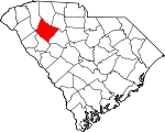
Laurens County, South Carolina Basics:


Laurens County South Carolina - Government Site

Population: 66,234
Area: 714 square miles
County seat: Laurens
Area code(s) in use: 864
Time zone: EST
High school graduate or higher: 77.1%
Bachelor's degree or higher: 14.4%
Median household income: $38,829
Persons in poverty: 20.0%
Home ownership rate: 71.4%
Mean travel time to work: 24.2 minutes


Adjacent counties:
Abbeville  Anderson  Greenville  Greenwood  Newberry  Spartanburg  Union  

Find in South Carolina

Map of the Laurens County area


Our detail map of Laurens County shows the Laurens County, South Carolina boundary lines and other interesting items.

Places in Laurens County, South Carolina

  Airports     show all on map

Barksdale Field (historical), Carolina Cow Country Airport, Laurens County Airport, Ridgewood Air Airport, Sexton Airport, Thomason Airfield

  Bridges     show all on map

Cooper Bridge, Enoree Bridge, Gaines Bridge, Ligons Bridge, Maddox Bridge, Van Pattons Bridge

  Buildings     show all on map

Capitol Theatre, Clinton City Fire Department Station 1, Clinton City Fire Department Station 2, Clinton City Hall, Cross Hill Police Department, Echo Theater (historical), Gray Court Police Department, Hopewell Community House, James H Thomason Library, Laurens City Fire Department Station 1, Laurens City Fire Department Station 2, Laurens City Hall, Laurens County Courthouse, Laurens County Emergency Medical Services Station 1, Laurens County Emergency Medical Services Station 3, Laurens County Emergency Medical Services Station 4, Laurens County Emergency Medical Services Station 5, Laurens County Emergency Medical Services Station 6, Laurens County Fire Department, Laurens County Fire Department, Laurens County Fire Department Cross Hill Station 1, Laurens County Fire Department Cross Hill Station 2, Laurens County Fire Department Cross Hill Station 3, Laurens County Fire Department Cross Hill Station 4, Laurens County Fire Department Durbin Creek, Laurens County Fire Department Durbin Creek Substation, Laurens County Fire Department Ekom, Laurens County Fire Department Gray Court, Laurens County Fire Department Greenpond, Laurens County Fire Department Hickory Tavern Station 1, Laurens County Fire Department Hickory Tavern Station 2, Laurens County Fire Department Joanna Station 1, Laurens County Fire Department Joanna Station 2, Laurens County Fire Department Joanna Station 3, Laurens County Fire Department Maddens, Laurens County Fire Department Mountville, Laurens County Fire Department Renno Station 1, Laurens County Fire Department Renno Station 2, Laurens County Fire Department Renno Substation 2, Laurens County Fire Department Sandy Springs, Laurens County Fire Department Sandy Springs Station 2, Laurens County Fire Department Waterloo, Laurens County Fire Department Waterloo Station 2, Laurens County Fire Department Watt Mills, Laurens County Fire Department Western Laurens, Laurens County Fire Department Western Laurens Station 2, Laurens County Fire Department Youngs, Laurens County Fire Department Youngs Station 2, Laurens County Home, Laurens County Jail, Laurens COunty Library, Nellie Scott Library, Thornwell Childrens Homes, Whitten Center

  Capes     show all on map

The Forks

  Cemeteries     show all on map

Barksdale Cemetery, Beaverdam Cemetery, Bethabara Cemetery, Bethany Cemetery, Bethany Cemetery, Bethlehem Cemetery, Beulah Cemetery, Bolt Family Cemetery, Bramlett Cemetery, Cedar Grove Cemetery, Cheek Cemetery, Chesnut Ridge Cemetery, Cross Hill Cemetery, Dials Cemetery, Dillard Cemetery, Duncan Creek Cemetery, Durbin Creek Cemetery, Franklin Cemetery, Friendship Cemetery, Friendship Cemetery, Garrett Cemetery, Gray Court Cemetery, Green Pond Cemetery, Head Springs Cemetery, Henderson Cemetery, Highland Home Cemetery, Holy Grove Cemetery, Hopewell Cemetery, Hurricane Cemetery, Jersey Cemetery, Jones Cemetery, Kings Chapel Cemetery, Knight Cemetery, Langston Cemetery, Leesville Cemetery, Lisbon Cemetery, Little River Cemetery, Martin Cemetery, Memory Gardens, Mount Bethel Cemetery, Mount Galliger Cemetery, Mount Pleasant Cemetery, Mount Pleasant Cemetery, New Harmony Cemetery, New Liberty Cemetery, New Prospect Cemetery, Pleasant Grove Cemetery, Pleasant Hill Cemetery, Poplar Springs Cemetery, Princeton Cemetery, Rabun Creek Cemetery, Rocky Springs Cemetery, Rose Hill Cemetery, Rosemont Cemetery, Sandy Springs Cemetery, Sauls Chapel Cemetery, Shady Grove Cemetery, Smyrna Cemetery, Springfield Cemetery, Trinity Methodist Church Cemetery, Warrior Creek Cemetery, Wrights Cemetery

  Census     show all on map

Joanna Census Designated Place, Mountville Census Designated Place, Princeton Census Designated Place, Watts Mills Census Designated Place

  Churches     show all on map

All Saints Episcopal Church, Antioch Church, Assembly of God Church, Bailey Memorial United Methodist Church, Beaverdam Church, Beaverdam Church, Bellview Church, Bethabara Church, Bethany Church, Bethany Church, Bethel African Methodist Episcopal Church, Bethel Church, Bethel Church, Bethel Grove Church, Bethlehem Church, Bethlehem Church, Bethlehem Church, Beulah Church, Bonds Crossroads Pentecostal Holiness CHurch, Bramlett Church, Brewerton Church (historical), Broad Street United Methodist Church, Calvary Baptist Church, Campbell Chapel, Cedar Grove Church, Center Rabon Church, Central United Methodist Church, Chestnut Ridge Church, Christian Hope Church, Church of God, Church of God, Church of God of Prophecy, Church of the Epiphany, Cross Hill Baptist Church, Davidson Street Baptist Church, Dials Church, Duncan Creek Church, Duncan Creek Church, Durbin Creek Church, Eastside Church, Elizabeth Church (historical), Elze Church, Epworth United Methodist Church, Evening Light Baptist Church, Fairview Church (historical), Faith Church, Faith Church, First Assembly of God Church, First Baptist Church, First Baptist Church, First Baptist Church, First Baptist Church, First Pentecostal Church, First Presbyterian Church, First Presbyterian Church, First Presbyterian Church, First United Methodist Church, Flat Ruff Church, Free Will Church, Friendship Church, Friendship Church, Good Hope Church, Grace Covenant Presbyterian Church, Gray Court Methodist Church, Green Pond Church, Harmony Church, Harris Grove Church, Hartness-Thornwest Memorial Presbyterian Church, Head Springs Associate Reformed Pres Church (historical), Hebron Baptist Church, Henderson Church, Highland Home Church, Hillcrest Baptist Church, Holiness Church (historical), Holly Grove Church, Holy Spirit Church, Hopewell Church, Hopewell Church, Hurricane Church, Joanna Church of God, Kings Chapel, Knighton Chapel, Lanford Baptist Church, Langston Church, Laurel Hill Church, Leesville Church, Liberty Springs Presbyterian Church, Lisbon Church, Little River Church, Long Branch Church, Lucas Avenue Baptist Church, Lydia Baptist Church, Lydia Church of God, Lydia Pentecostal Church, Lydia Presbyterian Church, Milam Road Church, Mill Rock Church, Mount Athen Church, Mount Bethel Church, Mount Carmel Church, Mount Gallager Baptist Church, Mount Moriah Church, Mount Olive Church, Mount Olive Church, Mount Pleasant Church, Mount Pleasant Church, Mount Pleasant Church (historical), Mount Presbyterian Church, Mount Vernon Church, Mount Zion Church, Mount Zion Church, Mount Zion Church, Mountville Baptist Church, New Bethel Church, New Bethlehem Church, New China Church, New Durbin Church, New Friendship African Methodist Episcopal Church, New Grove Church, New Harmony Church, New Liberty Church, New Mount Pleasant Church (historical), New Prospect Church, New Prospect Church, New Salem Church, Northside Church, Odell Church (historical), Old Fields Presbyterian Church (historical), Ora Associate Reformed Presbyterian Church, Patterson Chapel, Piedmont Church, Pine Grove Church, Pleasant Grove Church, Pleasant Hill Baptist Church (historical), Poplar Springs Baptist Church, Popular Springs Church, Princeton Baptist Church, Providence Associate Reformed Presbyterian Church, Rabon Creek Church, Reedy Grove Church, Rock Bridge Church, Rocky Spring Church, Rocky Springs Church, Rose of Sharon Church, Saint Boniface Catholic Church, Saint James United Methodist Church, Saint Johns Lutheran Church, Saint Paul First Baptist Church, Sandy Springs Church, Sandy Springs Church (historical), Sardis Methodist Church (historical), Second Baptist Church, Shady Grove Church, Sharon Church, Shiloh Church, Smyrna Church, Soule Chapel Church, Spring Hill Church, Springfield Baptist Church, Springfield Church, Tabernacle Church (historical), The Triumphant Church, Trinity Church, Union Church, Walnut Grove Church, Warrior Creek Church, Wateree Church, Waterloo United Methodist Church, Wattsville Pentecostal Holiness Church, Webb Memorial Pentecostal Church, Welcome Church, Welcome Church, White Plains Church, Zion Hill Church

  Crossings     show all on map

Chiles Ferry (historical), Heads Ford, Interchange 10, Interchange 16, Interchange 19, Interchange 2, Interchange 22, Interchange 5, Interchange 51, Interchange 52, Interchange 54, Interchange 60, Interchange 9, Kinmans Ferry (historical), Musgrove Ford, Neilus Ferry (historical), Pinsons Ford, Rutledge Ford, Sandy Ford, Youngs Ferry (historical)

  Dams     show all on map

Abbott Pond Dam D-3017, Babb Pond Dam D-3018, Beaverdam Warrior WCD Dam 33 D-2982, Beaverdam Warrior WCD Dam Four D-3008, Beaverdam Warrior WCD Im Dam D-3022, Bedenbaugh Pond Dam Number One D-3003, Bedenbaugh Pond Dam Number Two D-3002, Blackmonds Pond Dam D-2987, Bob Jones Farm Pond Dam D-2965, Boyd Pond Dam D-3004, Boyds Mill Dam, Cannon Pond Dam D-2994, Cecils Incorporated Pond Dam D-2996, Clinton 308 Pond Dam D-2988, Clinton Industrial Park Dam D-3000, Clinton Thornwell Pond One Dam D-2990, Clinton Thornwell Pond Two Dam D-2991, Coopers Large Pond Dam D-3020, Copeland Pond Dam D-3006, Davis Pond Dam D-2992, Dennon Jones Lower Pond Dam D-2976, Dennon Jones Upper Pond Dam D-2975, Duncan Creek WCD Dam Number 10 D-2997, Duncan Creek WCD Dam Number Eight, Duncan Creek WCD Dam Number Seven D-3005, Ed Dohar Pond Dam D-3007, Elizabeth M Davis Pond Dam D-2993, Gibbs Pond Dam D-3026, Grace Pump Pond Dam D-2978, Heath Copeland Pond Dam D-3001, Hedden Pond Dam D-2981, Hendricks Pond Dam D-3024, Herberts Pond Dam D-3023, Hollingsworth Pond Dam D-2995, Ingraham Pond Dam D-3012, J A Bedenbaugh Pond Dam D-3016, Knights Pond Dam D-2969, Martins Last Pond Dam D-2967, Millikens Pond Dam, Pelletts Pond Dam D-3019, Riddle Pond Dam D-2966, Sarah Copeland Pond Dam D-2998, South Carolina Noname 30001 D-2989 Dam, South Carolina Noname 30002 D-2986 Dam, South Carolina Noname 30004 D-2971 Dam, South Carolina Noname 30005 D-2985 Dam, South Carolina Noname 30006 D-2984 Dam, South Carolina Noname 30009 D-3009 Dam, South Carolina Noname 30010 D-2983 Dam, South Carolina Noname 30012 Dam, South Carolina Noname 30013 D-2977 Dam, South Carolina Noname 30017 D-2974 Dam, South Carolina Noname 30020 D-2980 Dam, South Carolina Noname 30021 D-3014 Dam, South Carolina Noname 30022 D-3011 Dam, South Carolina Noname 30023 D-3010 Dam, South Carolina Noname 30024 D-3013 Dam, South Carolina Noname 30025 D-2972 Dam, South Carolina Noname 30026 D-2973 Dam, Teague Lake Dam D-2968, Virginia Coleman Pond Dam D-3015, Ware Shoals Dam, Ziegenfuss Pond Dam D-2970

  Falls     show all on map

Gordons Mill Falls, Great Falls

  Hospitals     show all on map

Bailey Memorial Hospital, Doyle Infirmary, Hays Hospital (historical), Laurens County Health Center, Laurens County Hospital, Surgery and Laser Center at Professional Park

  Locales     show all on map

Abercrombies Mill (historical), Andersons Mill (historical), Arnolds Mill (historical), Balls Mill (historical), Barksdale Square Shopping Center, Black Mill (historical), Boyds Mill (historical), Clinton Plaza Shopping Center, Community Cash Shopping Plaza, Coopers Mill (historical), Copeland Shopping Plaza, Dogwood Ridge Farm, Goodgions Mills, Gordons Mill (historical), Ingles Shopping Center, Knights Mill (historical), Lakeside Country Club, Mitchells Mill (historical), Musgrove Mill (historical), Niswongers Mill (historical), Philson Crossroads Rifle Range, Pool Town, Ridge Road Hunt Camp, Sign Board Crossroads, Sullivan Mill (historical), Tip Top Hunt Camp, Tip Top Lookout, Western Plaza Shopping Center, Wests Mills (historical), Wisemans Mill (historical)

  Mines     show all on map

Gray Court Quarry

  Parks     show all on map

Clinton Commercial Historic District, Jamie Penell Memorial Park, Laurens County PArk, Laurens Historic District, McMillan Park, Pine Haven Park, South Harper Historic District, Thornwell-Presbyterian College Historic District

  Populated Places     show all on map

Anglers Haven, Austin (historical), Baldwin, Barksdale, Black Gate, Bonds Crossroads, Brewerton, Bryson (historical), Clinton, Cold Point, Collins Lakeside Village, Cooks Crossroads, Cross Hill, Doubling (historical), Dover (historical), Dunlapsville (historical), Edens (historical), Ekom, Erie (historical), Garlington (historical), Goodwins Crossroads, Gray Court, Green Pond, Greenwood, Harris Springs, Hickory Tavern, Hollands (historical), Huntington (historical), Irby, Isle of Pines, Joanna, Lakeside, Lanford, Laurens, Lisbon (historical), Long Branch, Lydia Mills, Maddens, Martin Crossroads, Milton, Mount Gallagher, Mount Olive, Mountville, Neighbors Crossroads, Ora, Owens (historical), Owings, Philson Crossroads, Pine Land Shores, Poplar Springs, Powers Shop (historical), Princeton, Reedy River (historical), Renno, Simpson (historical), Smallwood, Spring Grove (historical), Stomp Springs, Tumbling Shoals (historical), Tylersville, Waterloo, Wattsville, White Plains Crossroad, Youngs

  Post Offices     show all on map

Laurens Post Office, Youngs Post Office (historical)

  Rapidss     show all on map

Tumbling Shoals, Wofford Shoals

  Reservoirs     show all on map

Abbotts Pond, Bedenbaugh Pond Number One, Bedenbaughs Pond Number Two, Blackmonds Pond, Bob Jones Farm Pond, Boyd Millpond, Boyds Mill Reservoir, Boyds Pond, Buzzard Roost, Cannon Pond, Cecils Incorporated Pond, Clinton Cotton Mill Pond, Coopers Large Pond, Copeland Pond, Currys Lake, Davis Pond, Dennon Jones Lower Pond, Dennon Jones Upper Pond, Doctor Scurrys Pond, Duncan Creek Watershed Number 6b Reservoir, Duncan Creek Watershed Number Five, Duncan Creek Watershed Two Reservoir, Duncan Creek WCD Lake Number Eight, Duncan Creek WCD Lake Number Seven, Ed Dohar Pond, Elizabeth M Davis Pond, Gibbs Pond, Grace Pump Pond, Grace Recreation Pond, Grace Second Sediment Pond, Heath Copeland Pond, Hedden Pond, Hendricks Pond, Herberts Pond, Hollingworths Pond, Industrial Waste Pond, J A Bedenbaugh Pond, Knights Pond, Lake Greenwood, Larry Crenshaw Pond, Martins Last Pond, Millikens Pond, Old Clinton Reservoir, Pelletts Pond, Sarah Copeland Pond, Teagues Lake, Thomas Lake, Virginia Coleman Pond, Ware Shoals Reservoir, Waste Stabilization 308 Pond, Waste Stabilization Thornwell Number Two Pond, Waste Thornwell Pond One, Ziegenfuss Pond

  Schools     show all on map

Academy Street School (historical), Antioch School (historical), Bailey School, Bailey School (historical), Barksdale Harnie School (historical), Beaver Dam School (historical), Belfast School (historical), Bell Street High School, Bethany School (historical), Bethel Grove School (historical), Bethel School (historical), Brewerton School (historical), Camak School, Cedar Grove School (historical), Center Point School (historical), Center Rabon School (historical), Central School (historical), Childrens Gift Academy, Christian Hope School (historical), Clinton High School, Clinton School, Coggins School (historical), Copeland School (historical), Copeland School (historical), Dendy School, Duncan Creek School (historical), Eastside Elementary School, Edens School (historical), Florida Street School (historical), Ford School, Garlington School (historical), Garlington Street Grammar School (historical), Gray Court-Owings School, Grays School (historical), Green Pond School (historical), Harris Grove School (historical), Hickory Tavern School, Hopewell School (historical), Hurricane School (historical), Langston School (historical), Laurens City School (historical), Laurens District High School, Laurens Junior High School, Laurens Primary School, Laurensville Female College (historical), Lonesome Dove School (historical), Long Branch School (historical), Long Branch School (historical), Mary Shane Memorial Grade School, Midway School, Mill Rock School (historical), Mount Carmel School (historical), Mount Galleger School (historical), Mount Olive School (historical), Mount Pleasant School (historical), Mount Pleasant School (historical), Mount Vernon School (historical), Mount Zion School (historical), Musgrove School (historical), New Bethel School (historical), New China School (historical), New Mount Pleasant School (historical), New Prospect School (historical), Oak Grove School (historical), Oak Grove School (historical), Oak Grove School (historical), Oak Grove School (historical), Piedmont School (historical), Poplar Springs School (historical), Presbyterian College, Providence School (historical), Reedy Grove School (historical), Renno School (historical), Rock Bridge School (historical), Rock Hill School (historical), Rock Springs School (historical), Rocky Mount School (historical), Rosemont School (historical), Sanders School, Sandy Springs School (historical), Shady Grove School (historical), Shady Grove School (historical), Spring Hill School (historical), Trinity Ridge School (historical), Wadsworth Number 2 School (historical), Wadsworth School (historical), Warrior Creek School (historical), Whitten Village Training School, Woodson School, Youngs School (historical)

  Streams     show all on map

Allisons Branch, Arnold Creek, Beards Fork Creek, Beaverdam Creek, Beaverdam Creek, Buckhead Creek, Burnt Mill Creek, Burris Creek, Buzzard Spring Branch, Campbell Creek, Cane Brake Branch, Cane Creek, Dirty Creek, Double Branch, Durbin Creek, Flannigans Branch, Fort Branch, Harold Branch, Horse Creek, Langston Branch, Lick Creek, Little Durbin Creek, Long Branch, Long Lick Branch, Mill Creek, Millers Fork, Mountain Creek, Ned Wesson Branch, North Campbell Creek, North Creek, North Rabon Creek, Odells Branch, Pumpkin Branch, Quaker Creek, Rabon Creek, Reedy Creek, Reedy Fork, Reedy River, Rickels Branch, Sand Creek, Saxton Branch, Scout Branch, Shell Creek, Simmons Creek, Sispring Branch, South Durbin Creek, South Fork Duncan Creek, South Rabon Creek, Stillhouse Branch, Stoddard Creek, Strouds Branch, Wallace Branch, Walnut Creek, Warrior Creek, Watkins Creek

  Summits     show all on map

Big Knob, Birds Mountain, Little Knob

  Towers     show all on map

Mountville Lookout Tower, Tip Top Lookout Tower, WECE-FM (Due West), WLBG-AM (Laurens), WNEH-TV (Greenwood), WPCC-AM (Clinton), WSSL-FM (Gray Court),

Laurens County, South Carolina Population By Race (2012 estimate)

RacePopulation
WhiteLaurens County White population 47,82147,820  
BlackLaurens County Black population 17,02217,022
MixedLaurens County Mixed population 795794
AsianLaurens County Asian population 265264
American IndianLaurens County American Indian population 199198
Hawaiian & Pacific IslanderLaurens County Hawaiian & Pacific Islander population 6666

Additional population tables :
State population table
South Carolina population by county