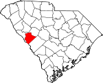
Edgefield County, South Carolina Basics:


Edgefield County South Carolina - Government Site

Population: 26,389
Area: 500 square miles
County seat: Edgefield
Area code(s) in use: 803
Time zone: EST
High school graduate or higher: 81.3%
Bachelor's degree or higher: 16.9%
Median household income: $44,208
Persons in poverty: 19.8%
Home ownership rate: 78.8%
Mean travel time to work: 26.6 minutes


Adjacent counties:
Aiken  Augusta - Richmond (GA)  Columbia (GA)  Greenwood  McCormick  Saluda  

Find in South Carolina

Map of the Edgefield County area


Our detail map of Edgefield County shows the Edgefield County, South Carolina boundary lines and other interesting items.

Places in Edgefield County, South Carolina

  Airports     show all on map

Edgefield County Airport

  Bridges     show all on map

Double Bridge, Gilgal Bridge, Madoc Bridge, Morgan Bridge, Shaw and McKee Bridge

  Buildings     show all on map

County Line Fire Department, County Line Fire Department Station 2, Edgefield County Emergency Medical Services, Edgefield Fire Department, Federal Correctional Institution Edgefield, Johnston Fire Department, Limestone Community Center, Merriwether Fire Department, Merriwether Fire Department, Northside Fire Department Main Station, Northside Fire Department Northside Substation, Reynolds Memorial Home, Rock Ridge Nursery, Trenton Correctional Institution, Trenton Fire Department Trenton, Trenton Police Department, Westside Fire Department Main Station, Westside Fire Department Westside Substation

  Cemeteries     show all on map

Bland Cemetery, Blocker Cemetery, Clark Cemetery, Cochran Cemetery, Corley Cemetery, Crafton Cemetery, DeLoach Cemetery, Dorn Cemetery, Eastview Cemetery, Frazier Cemetery, Griffis Cemetery, Hamilton Cemetery, Harling Cemetery, Hegwood Cemetery, Herin Cemetery, Hollingsworth-Walker Cemetery, Holmes Cemetery, Holmes Cemetery, Horne Cemetery, Liberty Spring Cemetery, Lott Cemetery, Marsh Cemetery, Marsh Cemetery, Martin Cemetery, McKie Cemetery, Meeting Grove Cemetery, Morris Cemetery, Moss Cemetery, Mount Nebo Cemetery, Mount of Olives Cemetery, Prescott Cemetery, Pressley Cemetery, Rutland Cemetery, Simkin Cemetery, Sweetwater Cemetery, Taylor Cemetery, Thurmond Cemetery, Warren Cemetery, Wicker Cemetery, Young Macedonia Cemetery

  Census     show all on map

Murphys Estates Census Designated Place

  Channels     show all on map

Four Mile Reach

  Churches     show all on map

Antioch Church, Antioch Church (historical), Barrs Chapel, Berea Church, Bethlehem Church, Bethlehem Church, Big Stevens Creek Church, Bland Church, Carey Hill Church, Cedar Grove Church, China Grove Church, Cockran Church (historical), Coleman Ridge Church, Colliers Church, Dothan Church, Ebenezer Church, Fairview Church (historical), Gilgal Church, Hardy Church (historical), Harmony Church, Highway Holy Church, Holmes Church (historical), Hopewell Church, Horn Creek Church, Jeter Church, Johnston Methodist Episcopal Church South, Johnston Presbyterian Church, Liberty Spring Church, Little Stevens Creek Church, Lotts Grove Church, Macedonia Church, McKendree Church, Moores Church, Mount Calvary Church, Mount Canaan Church (historical), Mount Olive Church, Mount Olive Church (historical), Mount Pleasant Church, Mount Zion Baptist Church, Mount Zion Church, Mount Zion Church, New Bethel Church, Old Macedonia Church, Philippi Church, Pine Grove Church, Pine Grove Church, Pine Hill Church, Piney Grove Church, Piney Grove Church, Pleasant Grove Church, Pleasant Lane Church, Poplar Spring Church, Red Hill Baptist Church, Red Oak Grove Church, Republican Church, Republican Grove Church, Rosa Spring Church, Rose Hill Church, Saint Marys Church, Science Hill Church, Shady Grove Church, Shaws Creek Church, Simmon Ridge Church, Spring Grove Church, Springfield Church, Union Church, Willow Springs Church, Young Macedonia Church

  Crossings     show all on map

Shaw and McKie Ferry (historical)

  Dams     show all on map

Augusta City Lock and Dam, Clark Pond Dam D-1695, Garner Pond Dam D-1697, Gibson Pond Dam D-1694, Harrison Pond Dam D-0906, Lick Fork Lake Dam D-0875, Luquire Pond Dam D-1698, Mathis Pond Dam D-1692, Raiford Pond Dam D-1700, Randall Pond Dam D-1699, South Carolina Noname 01108 D-0892 Dam, South Carolina Noname 01109 D-0891 Dam, South Carolina Noname 19001 D-0910 Dam, South Carolina Noname 19004 D-0871 Dam, South Carolina Noname 19007 D-0498 Dam, South Carolina Noname 19008 D-0893 Dam, South Carolina Noname 19009 D-0909 Dam, South Carolina Noname 19013 D-0609 Dam, South Carolina Noname 19014 D-0878 Dam, South Carolina Noname 19015 D-0911 Dam, South Carolina Noname 19016 D-0889 Dam, South Carolina Noname 19017 D-0870 Dam, South Carolina Noname 19018 D-0897 Dam, South Carolina Noname 19019 D-0894 Dam, South Carolina Noname 19020 D-0880 Dam, South Carolina Noname 19021 D-0868 Dam, South Carolina Noname 19023 D-0907 Dam, South Carolina Noname 19024 D-0497 Dam, South Carolina Noname 19025 D-0908 Dam, South Carolina Noname 19026 D-0895 Dam, South Carolina Noname 19027 D-0912 Dam, South Carolina Noname 19028 D-0506 Dam, South Carolina Noname 19029 D-0499 Dam, South Carolina Noname 19030 D-0874 Dam, South Carolina Noname 19032 D-0873 Dam, South Carolina Noname 19035 D-0872 Dam, South Carolina Noname 19036 D-0882 Dam, South Carolina Noname 19038 D-0867 Dam, South Carolina Noname 19039 D-0900 Dam, South Carolina Noname 19040 D-0901 Dam, South Carolina Noname 19041 D-0896 Dam, South Carolina Noname 19042 D-0899 Dam, South Carolina Noname 19043 D-0890 Dam, South Carolina Noname 19044 D01696 Dam, South Carolina Noname 19045 D-0905 Dam, South Carolina Noname 19046 D-0885 Dam, South Carolina Noname 19047 D-0884 Dam, South Carolina Noname 19048 D-0881 Dam, South Carolina Noname 19049 D-0879 Dam, South Carolina Noname 19050 D-0902 Dam, South Carolina Noname 19051 D-0903 Dam, South Carolina Noname 19052 Dam, South Carolina Noname 19053 D-0913 Dam, South Carolina Noname 19054 D-0869 Dam, South Carolina Noname 19055 D-0876 Dam, Stevens Creek Dam, Wall Pond Dam D-1691, Yonce Pond Dam D-1693

  Hospitals     show all on map

Edgefield County Hospital

  Islands     show all on map

Griffin Island (historical)

  Locales     show all on map

Brunson-Cleora Community Center, Camp Cofitachiqui, Camp Keener, Cooks Poultry Farm, Cyper Creek Picnic Grounds, Forks Campground, Furys Ferry Campsite, Lick Fork Campground, Limestone Farm, Marqurt Landing (historical), Moultries Mill (historical), Reams Store (historical), Red Hill, Rock Hill Society Hall, Titan Peach Farms, Tompkins Community House, West Side Community Center, Winn Store (historical)

  Mines     show all on map

Southern Gold Mine

  Parks     show all on map

Edgefield Historic District, Johnston Historical District, Ridge Nursery

  Populated Places     show all on map

Antioch, Bouknight, Brunson Crossroads, Cleora, Colliers, Crafton (historical), Edgefield, Harmony, Highview (historical), Huets Crossroads, Huntington Estates, Johnson Crossroads, Johnston, Lake Forest Estates, Lenoir (historical), Lime Stone (historical), Limestone, Mathais Crossroads, Mayson Crossroads, Meeting Street, Millers Crossroads, Morgana, Murphys Estates, New Richmond (historical), Parkhill, Pine House Crossroads, Pleasant Lane, Poverty Hill, Ropers Crossroads, Rotalata, Sullivan Crossroads, Swearingen (historical), Tompkins Cross Roads, Trenton, West Store Crossroads, Wise (historical)

  Post Offices     show all on map

Johnston Post Office

  Reservoirs     show all on map

Bigford Pond, Carpenters Pond, Corley Pond, Durkes Pond, Gregorys Lake, Harrison Pond, Holmes Pond, Holmes Pond, Holmes Pond, Johnston Sc Reservoir, Lick Fork Lake, Long Pond, Mathis Pond, Mathis Pond, Millers Pond, Odell Memorial Lake, One of the Arrowhead Lakes, Pearsons Pond, Rainsford Pond, Reynolds Pond, Ridgeview Lake, Ruckers Pond, Salters Pond, Samuels Pond, Scott Pond, Simons Lake, Slade Lake, Woodwards Lake, Yance Pond

  Schools     show all on map

Antioch School (historical), Bauknight School (historical), Bethelehem School (historical), Bethelehem School (historical), Bland School (historical), Briggs Quarter School (historical), Brunson School (historical), Cadley Grove School (historical), Carey Hill School (historical), Cartledge School (historical), Cedar Branch School (historical), Cedar Branch School (historical), Central School (historical), China Grove School (historical), China Grove School (historical), Cold Springs School (historical), Coleman Ridge School (historical), Collier School (historical), Colliers School (historical), Copper Spring School (historical), Courtney School (historical), Dorn School (historical), Douglas School, Edgefield County Training School (historical), Edgefield High School (historical), Elm Grove School (historical), Faulkner Mountain School (historical), Flat Rock School (historical), Flat Rock School (historical), Friendship School (historical), Frost Hill School (historical), Gardenville School (historical), Hammond Grove School (historical), Harmony School (historical), Harris Grove School (historical), Johnson School (historical), Johnston Elementary School, Johnston High School (historical), Johnston Primary School, Landrum School (historical), Liberty Spring School (historical), Limestone School (historical), Log Creek School (historical), Long Branch School (historical), Long Cane School (historical), Margunart School (historical), Moores School (historical), Mount Calvary School (historical), Mount Olive School (historical), Mount Pleasant School (historical), Mount Zion School (historical), Oak Grove School (historical), Oak Grove School (historical), Oak Grove School (historical), Oak Grove School (historical), Old Macedonia School (historical), Parker School, Pine Grove School (historical), Pine Grove School (historical), Pine Hill School (historical), Pine Hill School (historical), Pleasant Grove School (historical), Pleasant Lane School (historical), Pleasant Lane School (historical), Poplar Springs School (historical), Red Hill School (historical), Red Oak Grove School (historical), Robinson School (historical), Rock Grove School (historical), Ropers School (historical), Shaws Creek School (historical), Simmons Ridge School (historical), Spring Grove School (historical), Springfield School (historical), Sullivan School (historical), Susan Jamison Grove School (historical), Thurmond High School, Tompkins School (historical), Trenton High School (historical), Union School (historical), Walker School (historical), Walnut Grove School (historical), Wash School (historical), Wells Church (historical), West Pond School (historical), Willow Springs School (historical), Wimbley Branch School (historical), Young Macedonia School (historical), Zion Hill School (historical)

  Streams     show all on map

Anderson Branch, Bailey Branch, Bakers Branch, Bartley Branch, Beaverdam Creek, Bell Branch, Big Branch, Big Branch, Big Creek, Blue Branch, Broadwater Branch, Bubbling Branch, Buck Branch, Burkhalter Branch, Bussy Creek, Buzzard Branch, Camp Branch, Canaan Branch, Cartledge Branch, Cedar Creek, Center Spring Branch, Chap Branch, Cheves Creek, Clearwater Branch, Crooked Run, Cuffey Branch, Cyper Creek, Deep Step Branch, Dry Branch, Dry Creek, Dunn Creek, Flat Rock Branch, Flat Rock Creek, Gilroy Branch, Gundy Creek, Hall Branch, Hardy Branch, Hegwood Branch, Hillyer Branch, Hog Eye Branch, Horn Creek, Horse Branch, Jim Branch, Lick Fork, Little Beaverdam Creek, Little Mountain Creek, Little Stevens Creek, Little Turkey Creek, Lloyd Creek, Log Creek, Long Branch, Maulden Branch, Miller Branch, Monday Branch, Moss Branch, Mountain Creek, Owl Branch, Paces Branch, Pike Branch, Pitts Branch, Quaker Branch, Quarles Creek, Ray Creek, Red Hill Spring Branch, Reedy Branch, Rock Creek, Rock Creek, Rocky Creek, Rocky Creek, Sandhill Branch, Satcher Branch, Spring Branch, Stevens Creek, Stockman Branch, Sweetwater Branch, Temples Creek, Tiger Creek, Tobler Creek, White Branch, Williams Branch, Wilson Branch

  Summits     show all on map

Boles Mountain, Carey Hill, Poverty Hill

  Towers     show all on map

Liberty Hill Lookout Tower, WJES-AM (Johnston), WKSX-FM (Johnston), WKXC-FM (Aiken), WRXR-FM (Aiken)

  Trails     show all on map

Horn Creek Hiking Trail,

Edgefield County, South Carolina Population By Race (2012 estimate)

RacePopulation
WhiteEdgefield County White population 16,04516,044  
BlackEdgefield County Black population 9,8179,816
MixedEdgefield County Mixed population 317316
American IndianEdgefield County American Indian population 106105
Hawaiian & Pacific IslanderEdgefield County Hawaiian & Pacific Islander population 2626

Additional population tables :
State population table
South Carolina population by county