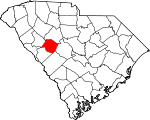
Saluda County, South Carolina Basics:


Saluda County South Carolina - Government Site

Population: 19,940
Area: 453 square miles
County seat: Saluda
Area code(s) in use: 864 803
Time zone: EST
High school graduate or higher: 77.7%
Bachelor's degree or higher: 12.8%
Median household income: $39,541
Persons in poverty: 18.1%
Home ownership rate: 73.9%
Mean travel time to work: 27.4 minutes


Adjacent counties:
Aiken  Edgefield  Greenwood  Lexington  Newberry  

Find in South Carolina

Map of the Saluda County area


Our detail map of Saluda County shows the Saluda County, South Carolina boundary lines and other interesting items.

Places in Saluda County, South Carolina

  Airports     show all on map

Etheredge Plantation Airport, Saluda County Airport, Scurry Airport

  Bridges     show all on map

Higgins Bridge

  Buildings     show all on map

Circle Fire Department Station 800, Delmar Community Center, Fair Haven Childrens Home, Hollywood Fire Department Number 700, Mayson Fire and Rescue Number 300, Midland Fire Department Number 900, Old Town Fire Department Number 600, Richland Springs Community House, Ridge Spring Fire Department Number 500, Ridge Spring Police Department, Saluda County Ambulance Service, Saluda County Courthouse, Saluda Fire Department Number 400, Saluda Police Department, South Carolina Highway Patrol Troop 2 Post C

  Cemeteries     show all on map

Asbill Cemetery, Bartley Cemetery, Bates Cemetery, Bates Cemetery, Bethany Cemetery, Bethel Cemetery, Bodie Cemetery, Bouknight Cemetery, Bouknight Cemetery, Burton Cemetery, Butler Cemetery, Carver Cemetery, Chestnut Hill Cemetery, Corinth Cemetery, Corley Cemetery, County Memorial Cemetery, Dry Creek Cemetery, Emory Cemetery, Etheredge Cemetery, Flat Rock Cemetery, Foulk Cemetery, Fouts Cemetery, Gassaway Cemetery, Gassaway Cemetery, Good Hope Cemetery, Gosset Cemetery, Harris Cemetery, Hill Cemetery, Holstein Cemetery, Holston Cemetery, Johnsons Cemetery, Jones Cemetery, Jones Cemetery, Lotts Cemetery, Matthews Cemetery, Matthews Cemetery, Matthews Cemetery, McGee Cemetery, Merchant Cemetery, Mill Town Cemetery, Mitchell Cemetery, Mitchell Cemetery, Mitchell Hill Cemetery, Mount Hebron Cemetery, Nazareth Cemetery, Norris Cemetery, Norris Cemetery, Norris Cemetery, Padgett Cemetery, Perry Cemetery, Pine Pleasant Cemetery, Prater Cemetery, Providence Cemetery, Raiford Cemetery, Richland Springs Cemetery, Ridge Springs Cemetery, Saint Williams Cemetery, Smith Cemetery, Thraikill Cemetery, Travis Park Cemetery, Warren Cemetery, Watson Cemetery, Watson Cemetery, Whittle Cemetery, Whittle Cemetery, Wise Cemetery, Wright Cemetery

  Churches     show all on map

Amick Grove Church, Bethany Church, Bethel Church, Bethel Number 1 Church, Bethlehem Church, Bethlehem Church, Beulah Church, Booser Hill Church (historical), Branch Hill Church, Butler Church, Butler Memorial Church, Cedar Grove Church, Chestnut Hill Church, Clydes Chapel, Corinth Lutheran Church, Corner Stone Christian Church, Crossroads Church, Deans Chapel, Double Branches Church, Dry Creek Church, Emory United Methodist Church, Faith Temple, Gassaway Church, Good Hope Church, Good Hope Lutheran Church, Hart Spring Church, Hibernian Church (historical), Hickory Grove Church, Holiness Tabernacle, Hopewell Church, Immanuel Church, Lockhart Church, Lucy Lockett Church (historical), Mine Creek Church, Mission Church (historical), Mitchell Hill Advent Church (historical), Mount Alford Church, Mount Alford Church (historical), Mount Calvary Church, Mount Enon Church, Mount Hebron Lutheran Church, Mount Moriah Church, Mount Moses Church, Mount Olive Church (historical), Mount Pleasant Lutheran Church, Mount Zion Church, Nazareth Church, Oak Grove Church, Open Bible Church (historical), Penn Creek Church, Philippi Church, Pine Pleasant Church, Pine Pleasant Church, Pleasant Hill Church, Poplar Branch Church, Providence Church (historical), Providence Church (historical), Red Bank Church, Reedy Branch Church, Rehoboth Church, Richland Springs Church, Ridge Branch Church, Ridge Hill Church, Rock Hill Church, Rocky Creek Church, Saint Marks Church, Saint Pauls Church, Saint Pauls Church, Saint Williams Church, Salem Church, Salem Church, Saluda Presbyterian Church, Sardis Church, Shady Grove Church, Shiloh Church, Shiloh Church, Skipjack Church, Spann Church, Speigner Church (historical), Spring Branch Church, Traywick Church (historical), Trinity Evangelical Lutheran Church, Universal Church, Ward Baptist Church, Wateree Church, Wesley Chapel, West Creek Church, White Rock Church, Zoar Church

  Crossings     show all on map

Wyses Ferry (historical)

  Dams     show all on map

Adams Pond Dam D-1593, Amicks Pond Dam D-1599, Berrys Pond Dam D-1598, Boatwrights Pond Dam D-1157, Burtons Pond Dam D-1256, Cullums Pond Dam D-1600, Felkels Pond Dam D-1149, Fricks Pond Dam D-0842, Halls Pond Dam D-1603, Herlongs Pond Dam D-1597, J A Holmes Pond Dam D-1199, J C Watson Pond Dam D-1601, Old Saluda Reservoir Dam D-0031, Padgetts Pond Dam D-1198, Ponderosos Pond Dam D-1154, R Colemans Pond Dam, R M Watsons Pond D-1156 Dam, Routons Pond Dam D-1201, South Carolina Noname 41001 D-1196 Dam, South Carolina Noname 41003 D-1607 Dam, South Carolina Noname 41004 D-1195 Dam, South Carolina Noname 41005 D-1197 Dam, South Carolina Noname 41007 D-1194 Dam, South Carolina Noname 41008 D-1206 Dam, South Carolina Noname 41010 D-1200 Dam, South Carolina Noname 41011 D-1202 Dam, South Carolina Noname 41012 D-1205 Dam, Vances Pond Dam D-1602, W Colemans Pond Dam D-1204, Wheelers Pond Dam D-1594, Wises Pond Dam D-1604, Yances Pond Dam D-1596

  Locales     show all on map

Amick Farms, Fruit Hill Community Center, Perrys Crossroads, Persimmon Hill Country Club, White Acres Farm

  Populated Places     show all on map

Big Creek, Blacks, Bleases Crossroads, Celestia (historical), Chapmans Crossroads, Colemans Crossroads, Corinth (historical), Delmar, Denny, Ellis (historical), Emory, Eulala, Fruit Hill, Good Hope, Hibernia, Hickory Grove, Higgins, Holston Crossroads, Jones Crossroads, Lake Murray Shores, Limp, Merchant (historical), Mobleys Crossroads, Mount Willing, Owdoms, Richland, Ridge Spring, Saluda, Speigner, Traus (historical), Ward, Wyses Ferry

  Post Offices     show all on map

Saluda Post Office

  Reservoirs     show all on map

Adams Pond, Amicks Pond, Asbill Pond, Berrys Pond, Boatwrights Pond, Burtons Pond, Cullums Pond, Felkels Pond, Fricks Pond, Halls Pond, Herlongs Pond, J A Holmes Pond, J C Watson Pond, New Saluda Reservoir, Old Saluda Reservoir, Padgetts Pond, Ponderosos Pond, R Colemans Pond, R M Watsons Pond, Routons Pond, Vances Pond, W Colemans Pond, Wheelers Pond, Wises Pond, Yances Pond

  Schools     show all on map

Batesburg Saluda School (historical), Bethany School (historical), Bethlehem School (historical), Bethlehem School (historical), Butler School (historical), Cane Brake School (historical), Cedar Grove School (historical), Cedar Grove School (historical), Centennial School (historical), Cherry Hill School (historical), Clyde School (historical), Cool Spring School (historical), Delmar School (historical), Emory School (historical), Etheridge School (historical), Eulala School (historical), Eulala School (historical), Eva School (historical), Fairfax School (historical), Fairview School (historical), Fruit Hill School (historical), Good Hope School (historical), Hart Springs School (historical), Hickory Grove School (historical), Hickory Grove School (historical), Higgins Rosenwald School (historical), Higgins School (historical), Holley School (historical), Hollywood High School, Hope Union School (historical), Lockhart School (historical), Mine Creek School (historical), Mount Moses School (historical), Mount Willing School (historical), Oak Grove School (historical), Penn Creek School (historical), Persimmon Creek School (historical), Philippi School (historical), Pine Grove School (historical), Pittsburg School (historical), Pleasant Grove School (historical), Plum Branch School (historical), Poplar Branch School (historical), Providence School (historical), Providence School (historical), Providence School (historical), Ready Creek School (historical), Red Hill School (historical), Richland School (historical), Ridge Branch Rosenwald School (historical), Ridge Hill High School, Riverside High School, Saluda Elementary School, Saluda High School, Saluda Rosenwald School (historical), Sardis School (historical), Shiloh School (historical), Suddath School (historical), Sumter School (historical), Sumter School (historical), Tillman School (historical), Trinity Rosenwald School (historical), Trinity School (historical), Utopia School, Watsen School (historical), Willow Branch School (historical), Zoar School (historical)

  Streams     show all on map

Bates Branch, Beaverdam Creek, Beech Creek, Big Creek, Bog Branch, Burnets Creek, Canebrake Branch, Clapboard Branch, Clouds Creek, Corley Branch, Dailey Creek, Dry Creek, Dry Creek, Dye Creek, Ephriam Branch, Flat Rock Branch, Flat Rock Branch, Gin Branch, Halfway Swamp Creek, Harris Branch, Indian Creek, Indian Creek, Jacobs Branch, Little Mine Creek, Little Saluda River, Long Branch, Mack Branch, Mill Creek, Mine Creek, Moores Creek, Mountain Creek, Penn Creek, Persimmon Creek, Peters Creek, Poplar Branch, Red Bank Creek, Richland Creek, Salem Branch, Shiloh Branch, Sleepy Creek, Spann Branch, Spring Creek, Terrapin Creek, Tosity Creek, Warren Branch, Watermelon Branch, West Creek

  Towers     show all on map

Faulkner Mountain Lookout Tower, Saluda Lookout Tower, WJRQ-FM (Saluda),

Saluda County, South Carolina Population By Race (2012 estimate)

RacePopulation
WhiteSaluda County White population 13,93813,938  
BlackSaluda County Black population 5,2445,244
American IndianSaluda County American Indian population 279279
MixedSaluda County Mixed population 219219
Hawaiian & Pacific IslanderSaluda County Hawaiian & Pacific Islander population 199199
AsianSaluda County Asian population 4039

Additional population tables :
State population table
South Carolina population by county