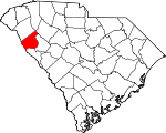
Abbeville County, South Carolina Basics:


Abbeville County South Carolina - Government Site

Population: 25,071
Area: 490 square miles
County seat: Abbeville
Area code(s) in use: 864
Time zone: EST
High school graduate or higher: 75.7%
Bachelor's degree or higher: 12.5%
Median household income: $35,067
Persons in poverty: 20.8%
Home ownership rate: 77.7%
Mean travel time to work: 26.7 minutes


Adjacent counties:
Anderson  Elbert (GA)  Greenville  Greenwood  Laurens  McCormick  

Find in South Carolina

Map of the Abbeville County area


Our detail map of Abbeville County shows the Abbeville County, South Carolina boundary lines and other interesting items.

Places in Abbeville County, South Carolina

  Airports     show all on map

Abbeville Airport, Hester Memorial Airport, Rambos Field Airport

  Bars     show all on map

Trotters Shoals

  Bridges     show all on map

Fairs Bridge, Irwin Bridge, Memorial Bridge, Morton Bridge, Tucker Bridge

  Buildings     show all on map

Abbeville City Fire Department, Abbeville County Courthouse, Abbeville County Emergency Medical Services, Abbeville County Fire Department Antreville, Abbeville County Fire Department Bethiah, Abbeville County Fire Department Broadmouth Turkey Creek, Abbeville County Fire Department Calhoun Falls, Abbeville County Fire Department Cold Spring, Abbeville County Fire Department Donalds, Abbeville County Fire Department Edgewood, Abbeville County Fire Department Headquarters, Abbeville County Fire Department Keowee, Abbeville County Fire Department Long Cane, Abbeville County Fire Department Lowndesville, Abbeville County Fire Department McGill, Abbeville County Fire Department Monterey, Abbeville County Fire Department Sharon, Abbeville County Health Center, Abbeville Museum, Abbeville Opera House, Abbeville Public Library, Abbeville Water Plant, Calhoun Falls Police Department, Due West Fire Department, Lowndesville Police Department

  Cemeteries     show all on map

Aiken Cemetery, Ashley Cemetery, Bells Chapel Cemetery, Bethiah Cemetery, Bethlehem Cemetery, Big Adams Cemetery, Broadmouth Baptist Cemetery, Calhoun Cemetery, Daniels Cemetery, Donalds Cemetery, Due West Cemetery, Due West Cemetery, Duncan Cemetery, Ebeneezer Cemetery, Gilgal Cemetery, Harpers Cemetery, Hester Cemetery, Hobson Cemetery, Kay Cemetery, Keowee Cemetery, Lebanon Cemetery, Little Adams Cemetery, Little Mountain Cemetery, Little River Cemetery, Long Cane Cemetery, McClain Cemetery, Melrose Cemetery, Midway Cemetery, Old Gilgal Cemetery, Old McCalla Cemetery, Old Rocky River Cemetery, Old Zion Cemetery, Powers Cemetery, Providence Cemetery, Ridge Cemetery, Rocky River Cemetery, Rocky River Cemetery, Saint John Cemetery, Saint Johns Cemetery, Salem Cemetery, Salem Cemetery, Sharon Cemetery, Shiloh Cemetery, Smyrna Cemetery, Smyrna Cemetery, Tolbert Cemetery, Trinity Cemetery, Turkey Creek Cemetery, Upper Long Cane Cemetery, Warrenton Cemetery, Winona Cemetery

  Census     show all on map

Antreville Census Designated Place, Lake Secession Census Designated Place

  Churches     show all on map

Abbeville Associate Reformed Presbyterian Church, Abbeville Presbyterian Church, Allen Chapel, Bells Church, Bells Church (historical), Bethel Methodist Church, Bethiah Presbyterian Church, Bethlehem Associate Reformed Presbyterian Church, Beulah Baptist Church, Beulah Baptist Church (historical), Broadmouth Baptist Church, Brown Oaks Church, Calhoun Falls Church of God, Calhoun Falls United Methodist Church, Calvary Baptist Church, Calvary Church, Campfield Church, Canaan Church, Canaan Church (historical), Cedar Spring Church (historical), Church of God of Prophecy, Cross Road Ministries, Cypress Chapel, Diamond Hill Church (historical), Donalds Baptist Church, Donalds United Methodist Church, Due West Associate Reformed Presbyterian Church, Due West Baptist Church, Ebenezer Church, Fairfield Church, First Baptist Church, First Baptist Church, Flat Rock Church, Forksville Baptist Church, Free Will Church, Friendship Baptist Church, Friendship Church, Gilgal Church, Glovers Church, Grace Chapel African Methodist Episcopal Church, Grace United Methodist Church, Holiness Church (historical), Hudson Pentecostal Church (historical), Hutchinsons Chapel (historical), Jacobs Chapel, Johns Creek Baptist Church, Jones Chapel, Keowee Baptist Church, Lebanon Presbyterian Church, Little Mountain Presbyterian Church, Little River Baptist Church, Lowndesville Baptist Church, Lowndesville Pentecostal Holiness Church, Main Street United Methodist Church, Midway Baptist Church, Mose Chapel, Moses Chapel (historical), Mount Calvary Church, Mount Clement Church, Mount Lebanon Church, Mount Olive Church, Mount Olive Church, Mount Olive Holiness Church of God, Mount Vernon Church, Mount Zion United Presbyterian Church, Mountain Church, Mulberry Church, Northside Baptist Church, Pentecostal Holiness Church, Poplar Grove Chapel, Providence Presbyterian Church, Ridge Church, Rock Buffalo Church, Rockhill Church, Rocky River Baptist Church, Rocky River Church, Rocky River Presbyterian Church, Sacred Heart Catholic Church, Saint James African Methodist Episcopal Church, Saint John Church, Saint John Church (historical), Saint Mary Baptist Church, Saint Peters Church, Salem Church, Shady Grove Church, Sharon Church, Shiloh United Methodist Church, Smyrna Church (historical), Smyrna United Methodist Church, South Side Baptist Church, Southside Baptist Church, Springfield Baptist Church, Springfield Baptist Church, Tabernacle Church, Trinity Episcopal Church, Turkey Creek Baptist Church, Union Baptist Church, Union Chapel, Upper Long Cane Presbyterian Church, Walnut Grove Church, Warrenton Presbyterian Church, Washington Street Presbyterian Church, Welcome Presbyterian Church, Westside Baptist Church, Wilson Creek Number 2 Church, Winona Baptist Church, Zion Holiness Church

  Crossings     show all on map

Bowman Ferry (historical), Calhoun Ferry (historical), Cherokee Ferry (historical), Cherokee Ford, Harpers Ferry (historical), Moseley Ferry (historical)

  Dams     show all on map

Ashley Pond Dam D-3036, B B Dunn Pond Dam D-3027, Featherstone Pond Dam D-3028, Four H Club Dam D-3040, H Patterson Pond Dam D-3030, J W Wilson Pond Dam D-3031, Latimer Pond Dam D-3033, Mays Pond Dam D-3038, Paradise Valley Lake Dam D-3029, South Carolina Noname 01001 D-3039 Dam, South Carolina Noname 01002 D-0914 Dam, South Carolina Noname 01003 D-3037 Dam, South Carolina Noname 01004 D-3035 Dam, South Carolina Noname 01005 D-3034 Dam, South Carolina Noname 01006 D-3042 Dam, South Carolina Noname 01007 Dam, Stalls Pond Dam D-3041, W T Wilson Pond Dam D-3032

  Hospitals     show all on map

Abbeville Area Medical Center

  Lakes     show all on map

Sherard Lake

  Locales     show all on map

Abbeville County Farm, Abbeville County Farm (historical), Abbeville Pumping Station, Barnes Mill (historical), Calhoun Falls Country Club, Douglas Mill (historical), Fell Hunt Campground, Irwin Mill (historical), Johnsons Mill (historical), McCaw Poultry Farm, Midway Hunt Campground, Parsons Mountain Lake Campground, Smith Store (historical)

  Parks     show all on map

Abbeville Historic District, Calhoun Falls Park, Cedar Springs Historic District, Court Square, Edgewood Park, Erskine College-Due West Historic District, Long Cane Scenic Area

  Populated Places     show all on map

Abbeville, Antreville, Arborville, Bethel, Bethiah, Blue Heaven, Boneo, Brick House, Broadmouth, Brownlee Crossroads, Buck Stand, Calhoun Falls, Cana (historical), Cedar Springs, Central-Shiloh, Charleston Crossroads, Chesnut Hill (historical), Clatworthy Crossroads, Cold Spring, Crosby (historical), Dann (historical), Darraugh, Diamond Hill Spring (historical), Donalds, Dover (historical), Drake, Dresden (historical), Due West, Duke (historical), Fairs Crossroads, Foxville Crossroads, Gilgal, Hammett (historical), Hester, Iris, Keowee, Lake Secession, Latimer, Level Land, Long Cane (historical), Lowndesville, MacArthurs Junction, Millers Grove (historical), Millers Mill, Millwood (historical), Monterey (historical), Murray (historical), Rocky River (historical), Sharon, Shiloh, Smithville, Smithville (historical), The Hook (historical), Vermillion, Warrenton, Watts, West View, Winona

  Post Offices     show all on map

Lowndesville Post Office

  Rapidss     show all on map

Cherokee Shoals, Dear Shoals, Johnson Shoals, Maddox Shoals, Rapley Shoals, Rutledge Shoals

  Reservoirs     show all on map

American Legion Lake, C F Saver Company Farm Lake, Calhoun Falls Country Club Lake, Four H Club Lake, L R Powell Lake, Lake Forrest, Legion Lake, Parson Mountain Lake, Parsons Mountain Lake, Secession Lake, Wakefield Pond

  Schools     show all on map

Abbeville County Training School (historical), Abbeville High School, Abbeville Mill Grade School (historical), Antreville School, Arbonville School (historical), Bethea School (historical), Bethel School, Bethiah School (historical), Bluff School (historical), Broadmouth School (historical), Brownlee School (historical), Burnt House School (historical), Calhoun Falls High School, Campbell School (historical), Cana School (historical), Carver School, Cedar Grove School (historical), Cedar Spring School (historical), Central School (historical), Chappell School, Cold Spring School, Diamond Hill School (historical), Dixie High School, Donalds Elementary SChool, Donalds High School (historical), Dry Holler School (historical), Dry Hollow School (historical), Due West Elementary School, Edgewood School, Ellison School (historical), Erskine College, Eureka School (historical), Fairfield School (historical), Foxville School (historical), Friendship School (historical), Gilmore School (historical), Greenville Street Elementary School, Grover Chapel School (historical), Hagen School (historical), Harrisburg Street Grade School (historical), John C Calhoun Elementary School, Johnson School (historical), Langley Miliken Elementary School, Level Land School (historical), Long Cane School, Long Cane School, Lowndesville Academy (historical), Lowndesville Elementary School (historical), Lowndesville High School (historical), Mill School, Mount Bethlehem School (historical), Mount View School (historical), Mount Zion School (historical), Mulberry School, Piervillle School (historical), Pine Burr School, Pine Grove School, Pine Grove School (historical), Pine Grove School (historical), Piney Grove School (historical), Piney Grove School (historical), Pleasant Grove School, Poplar Grove Davidic School (historical), Poplar Grove School (historical), Reileys School (historical), Rock Buffalo School (historical), Rock Hill School, Rock Hill School (historical), Rock Spring School (historical), Rock Springs School (historical), Rocky River School (historical), Shady Grove School, Shady Grove School (historical), Sharon School, Shiloh School, Smith Cross Roads School (historical), Smithville School, South Main Street School (historical), Tabernacle School, The Learning Center, Vermillion School (historical), Walnut Grove School, Westview School (historical), Winora School (historical), Wright Middle School

  Springs     show all on map

Diamond Spring

  Streams     show all on map

Adams Branch, Allen Creek, Bagg Creek, Bailey Creek, Baskin Branch, Beer Garden Creek, Big Curltail Creek, Blacks Creek, Blue Hill Creek, Bowie Branch, Bowman Branch, Calhoun Branch, Calhoun Creek, Camp Creek, Candy Branch, Charlies Creek, Chickasaw Creek, Church Branch, Cochran Branch, Corner Creek, Deal Creek, Double Branch, Dry Creek, East Buckhorn Creek, Fell Branch, Flagreed Creek, George Devlin Branch, Gibson Creek, Gill Creek, Goose Creek, Grays Creek, Grays Creek, Gypsy Creek, Hammond Branch, Hillbern Creek, Hogskin Creek, Jim Knox Branch, Job Creek, Johns Creek, Johnson Creek, Keller Branch, Little Curltail Creek, Little Hogskin Creek, Little Muckaway Creek, Long Branch, Long Branch, Long Branch, Manor Creek, McCord Creek, McCord Creek, McGill Branch, McKenley Creek, Miller Branch, Morrison Branch, Morrow Creek, Mountain Creek, Murray Creek, Norris Creek, Park Creek, Parker Creek, Penny Creek, Redd Creek, Reid Creek, Reids Creek, Richie Branch, Rocky River, Shanklin Creek, Spur Creek, Stillhouse Branch, Tanyard Branch, West Beards Creek, West Buckhorn Creek, Wharton Branch, White Creek, Wilder Creek, Wilson Creek

  Summits     show all on map

Parsons Mountain

  Towers     show all on map

Lowndesville Lookout Tower, Parsons Mountain Lookout Tower, WABV-AM (Abbeville), WZLA-FM (Abbeville),

Abbeville County, South Carolina Population By Race (2012 estimate)

RacePopulation
WhiteAbbeville County White population 17,52517,524  
BlackAbbeville County Black population 7,0707,070
MixedAbbeville County Mixed population 301300
AsianAbbeville County Asian population 100100
American IndianAbbeville County American Indian population 7575
Hawaiian & Pacific IslanderAbbeville County Hawaiian & Pacific Islander population 00

Additional population tables :
State population table
South Carolina population by county