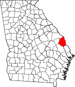
Screven County, Georgia Basics:


Screven County Georgia - Government Site

Population: 14,219
Area: 645 square miles
County seat: Sylvania
Area code(s) in use: 912
Time zone: EST
High school graduate or higher: 77.1%
Bachelor's degree or higher: 11.7%
Median household income: $34,634
Persons in poverty: 24.8%
Home ownership rate: 74.4%
Mean travel time to work: 29.0 minutes


Adjacent counties:
Allendale (SC)  Bulloch  Burke  Effingham  Hampton (SC)  Jenkins  

Find in Georgia

Map of the Screven County area


Our detail map of Screven County shows the Screven County, Georgia boundary lines and other interesting items.

Places in Screven County, Georgia

  Airports     show all on map

Landings East Sylvania Airport, Millhaven Airport, Pegasus Ranch Airport, Plantation Airpark, Wade Plantation Airport

  Bays     show all on map

Horse Pen Bay, Telfair Bay

  Bends     show all on map

Thompson Long Round

  Bridges     show all on map

Bests Bridge, Brannons Bridge, Bryans Bridge (historical), Burtons Ferry Bridge, Fred W Hodges Bridge, Hilltonia Bridge, Hilton Bridge, Huggins Bridge (historical), Jacksonboro Bridge, McCall Bridge, Nelson Bridge, New Bridge (historical), Roberts Bridge, Six Bridges (historical)

  Buildings     show all on map

Georgia State Patrol Troop F Post 21 Sylvania, Hiltonia Police Department, Hiltonia Volunteer Fire Department, Jenk Hill Volunteer Fire Department, Newington Area Volunteer Fire Department, Newington Police Department, Oliver Police Department, Rocky Ford Police Department Headquarters, Screven County Correctional Institution, Screven County Courthouse, Screven County Fire Department Station 1, Screven County Fire Department Station 3, Screven County Fire Department Station 6, Screven County Fire Department Station 8, Screven County Fire Department Station 9, Screven County Jail, Screven County Library, Screven County Sheriff's Department, Sylvania City Hall, Sylvania Fire Department, Sylvania Police Department

  Capes     show all on map

Fridays Dream Point, Jacob Jump Point, Mosquito Camp Point, Saucy Boy Point, Whirligig Point, White Womans Point

  Cemeteries     show all on map

Bascom Cemetery, Bethel Cemetery, Black Creek Cemetery, Black Creek Cemetery, Braggs Cemetery, Bryan Cemetery, Buck Creek Cemetery, Cameron Cemetery, Doughtry Cemetery, Ellis Chapel Cemetery, Eneck Cemetery, Friendship Memorial Cemetery, Howard Cemetery, Hurst Cemetery, Lee Cemetery, Lewis Cemetery, Little Horse Creek Cemetery, Lovetts Cemetery, Meek Cemetery, Middle Ground Cemetery, Mount Pleasant Cemetery, Mount Pleasant Cemetery, Oak Grove Cemetery, Oak Grove Cemetery, Parker Cemetery, Parker Cemetery, Peggy Zeigler Cemetery Two, Reddick Cemetery, Reddick Cemetery, Rocky Ford Cemetery, Simmons Branch Cemetery, Springhead Cemetery, Sylvania Cemetery, Thompson Cemetery, Union Cemetery, Wades Cemetery, Waters Cemetery, Zeigler Cemetery Three

  Census     show all on map

Cooperville Census Designated Place

  Channels     show all on map

Cornhouse Reach, Little Cornhouse Reach, Mosquito Camp Cutoff, Wildcat Cut

  Churches     show all on map

Antioch Church, Bargeron Church, Bascom Church (historical), Benton Grove Church, Bethel African Methodist Episcopal Church, Bethel Brick Church, Bethlehem Church, Bible Church, Bible Fellowship Church, Black Creek Church, Black Creek Church, Blue Springs Church, Buck Creek Church, Camp Grove Church, Charlestown Church, Comers Grave Church, Cyphus Pond Church, Dalton Church, Ditch Pond Church, Dixon Branch Church, Double Heads Church, Douglas Branch Church, Faith Temple, First Baptist Church, First Methodist Church, Free Will Church, Friendship Church, Friendship Memorial Church, Friendship Tabernacle, Goloid Church, Goodwill Church, Great Bethel African Methodist Episcopal Church, Green Hill Church, Greenwood Church, Grove Church, Harmony Church, Hurst Church, Jackson Church, Johnson Grove Church, Jordan Church, Lariscy Grove Church, Lawton Grove Church, Lee Memorial Church (historical), Little Bethel Church, Little Horse Creek Church, Little Horse Creek Church, Louis Chapel, Lovett Hill Church, Lovett Temple (historical), McBride United Methodist Church, McBridge Church, McDonald Church, Memorial Church, Middle Baptist Assembly, Middle Branch Church, Middle Ground Church, New Home Welcome Church, New Light Church, New Robbins Branch Church, Newington Baptist Church, North Newington Church, Oak Grove Church, Oak Grove Church, Offerman Baptist Church, Ogeechee Branch Church, Ogeechee Church, Our Lady of the Assumption Church, Parker Grove Church, Red Bluff Church, Robert Grove Church, Rock Hill Church, Rocky Ford Baptist Church, Saint Andrews Chapel, Saint Andrews Methodist Episcopal Church, Saint Johns Church, Saint Johns Church, Saint Josephs Church, Saint Paul Baptist Church, Saint Pauls Church, Saint Peter African Methodist Episcopal Church, Saint Peters Church, Saint Puals Church, Saint Stephens Church, Simmons Branch Church, Springhead Church, Union Church, Wades Church, Waters Grove Church, Weaver Tabernacle, Wesley Anna Church, Wesley Chapel, Wesley Church, Williams Chapel, Zion Church, Zion Fair Church

  Cliffs     show all on map

Tiger Leap Bluff

  Crossings     show all on map

Burtons Ferry (historical), Hudson Ferry (historical)

  Dams     show all on map

Austin Pond Dam, Bennett Lake Dam, Blalock Pond Dam, Boddiford Pond Dam, Borken Pond Dam, Carter Lake Dam, Charlie Pond Dam, Dixon Pond Dam, Freeman Pond Dam, Grist Mill Pond Dam, Hagan Pond Dam, Huggins Lake Dam, Kimberly-Clark Lake Dam, Lariscy Lake Dam, Lewis Pond Dam, Miller Pond Dam, Millhaven Lake Number Two Dam, Millhaven Pond Dam, Nelson Pond Dam, Newton Pond Dam, Pierce Pond Dam, Pryor Pond Dam, Railroad Pond Dam, Robinson Pond Dam, Robinson Pond Dam, Wade Lake Number One Dam, Wade Lake Number Two Dam

  Hospitals     show all on map

Screven County Hospital

  Islands     show all on map

Beaufort Island

  Lakes     show all on map

Barnes Lake, Beaver Pond, Bird Pond, Brierpatch Lake, Carlton Pond, Clyde Pond, Conyers Lake, Edwards Pond, Hershman Lake, Jarrell Pond, Johnson Lake, Lee Pond, Miller Lake, Mud Fish Pond, Noonan Pond, Possum Eddy, Queen Lake, Red Lake, Smith Lake, Stink Pond, Story Pond, The Lagoon

  Locales     show all on map

Bay Branch, Blacks Landing, Blue Springs Landing, Brantley Plaza Shopping Center, Brier Creek Country Club, Cains Store, Canes Store (historical), Coastal Empire Christian Camp, Eneck Landing, Evans Landing, Hendersons Landing, Hudson Ferry Landing, Jacobsons Landing, Kittles Landing, Opies Landing, Pfeiffers Landing, Poor Robin Landing, Rice Landing, Sylvania Water Pollution Control Plant

  Military     show all on map

Sylvania Army Air Field (historical)

  Parks     show all on map

Jacksonboro Monument

  Populated Places     show all on map

Altman, Bascom, Blue Hole Mobile Home Park, Blue Springs, Brier Creek Landing, Burtons Ferry Landing, Cameron, Captolo, Cooperville, Double Heads, Dover, Eneck (historical), Eureka Springs (historical), Farmdale, Goloid, Green Hill, Halcyondale, Hiltonia, Hunters, Jacksonboro (historical), Lewis, Middleground, Millhaven, Mount Pleasant (historical), Newington, Ogeechee, Oliver, Parkers, Pfeiffer (historical), Red Bluff Landing, Resource, Rocky Ford, Sheppards, Stalco, Sylvania, Thomasboro, Waters, White Hill, Woodcliff, Zeigler

  Post Offices     show all on map

Newington Post Office, Sylvania Post Office

  Reservoirs     show all on map

Austin Pond, Bennett Lake, Blalock Pond, Boddiford Pond, Borken Pond, Cains Pond, Carter Lake, Charlie Pond, Clay Lake, Dixon Pond, Freemam Pond, Grist Mill Pond, Hagan Pond, Huggins Lake, Julie Pond, Kimberly-Clark Lake, Lariscy Lake, Lewis Pond, Meldrin Millpond, Miller Pond, Millhaven Lake Number Two, Millhaven Pond, Murray Pond, Nelson Pond, Newton Pond, Pierce Pond, Prescott Lakes, Pryor Pond, Railroad Pond, Railroad Pond Dam, Ralph Lake, Robinson Pond, Robinson Pond, Sandy Wash Lake, Ski Pond, Spring Lake, Wade Lake Number One, Wade Lake Number Two

  Schools     show all on map

Arnett School, Bascom School (historical), Bay Branch School (historical), Blue Springs School (historical), Boyds School (historical), Burke School (historical), Captolo School (historical), Central Middle School, Co Academy, Colson School (historical), Community Christian School, Cooperville School (historical), Coursey School (historical), Elmwood School (historical), Evans School (historical), Free Chapel School (historical), Gilgal School (historical), Goloid School (historical), Green Hill School (historical), Harwell School (historical), Hook School (historical), Hurst School (historical), Jackson School (historical), Little Horse Creek School (historical), Little Horse Creek School (historical), Loving Hill School (historical), Middle Ground School (historical), Millhaven School, Pine Grove School (historical), Pine Vale School (historical), Rock Hill School (historical), Saint Peters School (historical), Screven County Elementary School, Screven County High School, Screven County Middle School, Southside School, Sylvania Elementary School, Walker Academy (historical), Walker Grove School (historical), Walker School (historical), Wesley School (historical), Zion School (historical)

  Springs     show all on map

Blue Springs, Blue Springs

  Streams     show all on map

Bay Branch, Beard Old River, Beaverdam Creek, Beaverdam Creek, Big Branch, Black Creek, Brady Branch, Braggs Mill Creek, Brier Creek, Buck Creek, Carter Branch, Comers Branch, Crooked Creek, Douglas Branch, Dry Branch, Ferry Branch, Flat Branch, Hen Coop Branch, Henderson Mill Branch, Hendersons Mill Branch, Horse Creek, Horsepen Branch, Indian Branch, Jackson Branch, Jackson Branch, Joe Ditch, Limestone Branch, Little Beaverdam Creek, Little Black Creek, Little Horse Creek, Long Branch, McDaniel Creek, McDonald Branch, Mile Branch, Mill Branch, Nancy Branch, Ogeechee Creek, Old River, Peavey Creek, Quill Branch, Robbins Branch, Rocky Creek, Rooty Branch, Simmons Branch, South Fork Ogeechee Creek, South Prong Buck Creek, Waterhole Branch

  Swamps     show all on map

Eneck Bay, Mobley Bay, Mobley Swamp, Moon Change Swamp, Morgan Bay, Oliver Swamp

  Towers     show all on map

WSYL-AM (Sylvania),

Screven County, Georgia Population By Race (2012 estimate)

RacePopulation
WhiteScreven County White population 7,8777,877  
BlackScreven County Black population 6,0436,043
MixedScreven County Mixed population 171170
AsianScreven County Asian population 7171
American IndianScreven County American Indian population 5756
Hawaiian & Pacific IslanderScreven County Hawaiian & Pacific Islander population 00

Additional population tables :
State population table
Georgia population by county