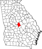
Twiggs County, Georgia Basics:


Twiggs County Georgia - Government Site

Population: 8,518
Area: 358 square miles
County seat: Jeffersonville
Area code(s) in use: 478
Time zone: EST
High school graduate or higher: 70.8%
Bachelor's degree or higher: 10.9%
Median household income: $30,533
Persons in poverty: 27.4%
Home ownership rate: 80.0%
Mean travel time to work: 27.1 minutes


Adjacent counties:
Bibb  Bleckley  Houston  Jones  Laurens  Wilkinson  

Find in Georgia

Map of the Twiggs County area


Our detail map of Twiggs County shows the Twiggs County, Georgia boundary lines and other interesting items.

Places in Twiggs County, Georgia

  Airports     show all on map

Danville Airpark

  Bridges     show all on map

H A Fountain Bridge

  Buildings     show all on map

Danville Volunteer Fire Department, Dry Branch Volunteer Fire Department, Higgsville Volunteer Fire Department, Jeffersonville Fire Department, Jeffersonville Police Department, Jeffersonville Volunteer Fire Department, Pearson Volunteer Fire Department, Twiggs County Sheriff's Office

  Cemeteries     show all on map

Aires-Meadows Cemetery, Antioch Cemetery, Baker Cemetery, Beckham Cemetery, Beckham Cemetery, Beech Spring Cemetery, Bond Cemetery, Burkett Cemetery, Burns Cemetery, Concord Cemetery, English Cemetery, Epps - Champion Cemetery, Faulk Cemetery, Finch Cemetery, Fowler Cemetery, Gallmore - Chapman Cemetery, Glover Cemetery, Hale Cemetery, Hardy-Durham Cemetery, Jeffersonville Cemetery, Jones - Denson Cemetery, Kitchens Cemetery, Kitchens Cemetery, Land Cemetery, Laurel Grove Cemetery, Liberty Hill Cemetery, Linda Melton Late Cemetery, Lizzy Harold Cemetery, Marion Cemetery, McCollum Cemetery, Mercer Cemetery, Mount Zion Cemetery, Nelson Cemetery, New Haven Cemetery, New Hope Cemetery, New Hopewell Cemetery, O'Daniel Cemetery, Pearce Cemetery, Pearce Cemetery, Richland Cemetery, Sanders Cemetery, Smith Cemetery, Tharp Cemetery, Vaughn Cemetery, Wall Cemetery, Walters Cemetery, Wimberly Cemetery

  Churches     show all on map

Antioch Baptist Church, Antioch Church, Beech Spring Church, Bethlehem Church, Chance Hill Church, Church of God, Cool Springs Primitive Baptist Church, D D Memorial Church, Danville Baptist Church, Dry Branch Church, Edgewood Church, Elsharath Missionary Church, Faulks Chapel, First Congregational Holiness Church, Friendship Church, Gospel Mission, Greater New Hope Church, Griffin Give Church, Higginsville Church, Lar Grove Church, Liberty Hill Church, Lizzy Harold Church, Lucy Chapel, Mount Gilgal Church, Mount Olive Church, Mount Zion Church, Mount Zion Church, New Haven Church, New Hope Church (historical), New Hopewell Church, New Mount Zion Church, New Richland Baptist Church, Old Marion Church, Piney Grove Church (historical), Prospect Church, Richland Church, Rosebud Church, Shiloh Church, Shiloh Church, Stone Creek Church, White Spring Church

  Crossings     show all on map

Exit 6, Exit 7, Exit 8, Exit 9

  Dams     show all on map

Birdsong Pond Dam, Cason Lake Dam, Faulk Lake Dam, Faulk Lake East Dam, Faulk Lake West Dam, Harrisons Lake Dam, Hendricks Lake Dam, Hogan Lake Dam, Jolly Pond Dam, Lanier Lake Dam, Mallory Lake Dam, Myricks Mill Pond Dam, Snows Pond Dam, Stone Lake Dam, Worsham Lake Dam

  Lakes     show all on map

Big Eddy, Dove Pond, Eel Hole, Hamrick Lake, Jack Hole, McCallum Pond

  Locales     show all on map

Adams Park, Bullard Landing

  Military     show all on map

Nike Site R-28C (historical), Nike Site R-28L (historical)

  Populated Places     show all on map

Allentown, Bullard, Danville, District Path, Dry Branch, Fitzpatrick, Huber, Jeffersonville, Marion, Mount Calvary, Mount Olive, Myricks Mill, Reids, Ripley, Tarversville, Westlake

  Post Offices     show all on map

Danville Post Office, Dry Branch Post Office

  Reservoirs     show all on map

Birdsong Pond, Cason Lake, Faulk Lake, Faulk Lake East, Faulk Lake West, Harrisons Lake, Hendrick Pond, Hendricks Lake, Hogan Lake, Jolly Pond, Lanier Lake, Larson Pond, Mallory Lake, Myricks Millpond, Snows Pond, Stone Lake, Worsham Lake

  Schools     show all on map

Antioch School (historical), Beech Spring Academy (historical), Bullard School (historical), Central Georgia Technical College - Twiggs County Center, Chance Hill School (historical), Cool Springs School (historical), Crosland Academy (historical), Davidsons Academy (historical), Griffin School (historical), Jefferson Academy (historical), Jeffersonville Elementary School, Marion Academy (historical), Marion School (historical), Mount Zion School (historical), Mount Zion School (historical), Prospect School (historical), Richland School (historical), Shiloh School (historical), Stone Creek Academy (historical), Tarversville School (historical), Twiggs Academy, Twiggs County High School, Twiggs County North Complex School Number 1, Twiggs County North Complex School Number 2, Twiggs County South School, Twiggs Junior High School, Twiggs-Wilkinson School, White Springs School (historical)

  Streams     show all on map

Alligator Creek, Big Branch, Buck Branch, Camp Creek, Crooked Creek, Dogwood Branch, Dry Branch Creek, Flat Creek, Game Creek, Gum Swamp Branch, Hammocks Branch, Hasty Branch, Hogan Branch, Johnson Branch, Little Sandy Creek, Little Shellstone Creek, Mill Branch, Pennywinkle Branch, Richland Creek, Rosston Creek, Savage Creek, Scuffle Creek, Streetman Creek, Turvin Creek, Ugly Creek, Wolf Creek

  Swamps     show all on map

Denson Marsh, Rays Swamp

  Towers     show all on map

WAYS-FM (Macon), WBNM-AM (Gordon), WGNM-TV (Macon), WGXA-TV (Macon), WMAZ-TV (Macon), WPWB-FM (Byron), WWST-FM (Jeffersonville),

Twiggs County, Georgia Population By Race (2012 estimate)

RacePopulation
WhiteTwiggs County White population 4,8304,829  
BlackTwiggs County Black population 3,5353,534
MixedTwiggs County Mixed population 111110
American IndianTwiggs County American Indian population 3434
AsianTwiggs County Asian population 1717
Hawaiian & Pacific IslanderTwiggs County Hawaiian & Pacific Islander population 00

Additional population tables :
State population table
Georgia population by county