Bannock County, Idaho Basics:


Bannock County Idaho - Government Site

Population: 83,683
Area: 1112 square miles
County seat: Pocatello
Area code(s) in use: 208
Time zone: MST
High school graduate or higher: 91.8%
Bachelor's degree or higher: 27.2%
Median household income: $45,860
Persons in poverty: 14.1%
Home ownership rate: 70.2%
Mean travel time to work: 18.6 minutes
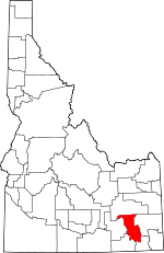
Adjacent counties:
Bingham  Caribou  Franklin  Oneida  Power  

Find in Idaho

Map of the Bannock County area


Our detail map of Bannock County shows the Bannock County, Idaho boundary lines and other interesting items.

Places in Bannock County, Idaho

  Airports     show all on map

Bannock Regional Medical Center Heliport, Downey Airport

  Basins     show all on map

Fish Creek Basin

  Benches     show all on map

Pocatello Bench

  Buildings     show all on map

Arimo Fire Department, Bannock County Sheriff's Office, Bureau of Land Management Pocatello Field Office, Chubbuck Fire Department, Chubbuck Police Department, Downey Volunteer Fire Department, Inkom City Police Department, Inkom Fire Department, Lava Hot Springs Volunteer Fire District, McCammon Volunteer Fire Department, Pocatello Fire Department Station 1 Region 6 Hazmat Team, Pocatello Fire Department Station 2, Pocatello Fire Department Station 3, Pocatello Fire Department Station 5, Pocatello Police Department, Pocatello Valley Fire Department Station 1, Pocatello Valley Fire Department Station 2, Pocatello Women's Correctional Center, Portneuf Medical Center West Campus, Safe Haven Hospital and Care Center

  Canals     show all on map

Arimo Ditch, Baker Lateral, Church Lateral, Covet Lateral, DuBois Lateral, Dubois Lateral, Evening Ditch, Facer Lateral, Farmer Ditch, Havenor Lateral, Havenor Siphon, Hay Lateral, Hayes Lateral, Hayes Lateral, Hooker Lateral, Lindian Lateral, Martin Lateral, Palm Lateral, Panther Lateral, Pear Lateral, Pine Lateral, Plum Lateral, Pole Lateral, Ponzo Lateral, Poplar Lateral, Portneuf Marsh Valley Canal, Redman Lateral, Reider Lateral, School Lateral, Smoke Lateral, Spraker Lateral, Stuart Lateral, Tyhee Lateral, Tyhee Wasteway

  Cemeteries     show all on map

Downey Cemetery, Grant Ward Cemetery, Indian Cemetery, Inkom Cemetery, Lava Hot Springs Cemetery, Marsh Center Cemetery, Marsh Valley Cemetery, Mountain View Cemetery, Robin Cemetery, Woodland Cemetery

  Census     show all on map

Fort Hall Census Designated Place, Tyhee Census Designated Place

  Dams     show all on map

Current Creek Dam, Hawkins Dam, Simplot Effluent Irrigation Dam, Wiregrass Dam

  Flats     show all on map

Big Flat, Elk Meadows, Justice Park

  Gaps     show all on map

Bennetts Pass, Garden Creek Gap, Inkom Pass, Red Rock Pass, Wild Horse Divide, Windy Pass

  Hospitals     show all on map

Portneuf Medical Center East Campus, Saint Anthony Hospital (historical)

  Lakes     show all on map

Horse Lake, Portneuf River Slough, Swan Lake

  Locales     show all on map

Alameda Plaza, Bannock County Fairgrounds, Bannock Guard Station, Blaser Station, Buffalo Lodge, Buttrey-Osco Family Center, Camp Tendoy, Caribou Ski Area, Cherry Creek Campground, Cherry Springs Campground, Cherry Springs Campground Picnic Area, Coulam, Foothill Plaza, Lower Portneuf Access Area, Marsh Center, North Pocatello, Onyx, Pebble Creek Ski Area, Pine Ridge Mall, Pocatello Mall, Putnam Lodge, Riverside Municipal Golf Course, Scout Mountain Campground, Silver Sage Girl Scout Camp, Summit Campground, Summit Guard Station, Upper Portneuf Access Area, Westwood Mall, Wiregrass Reservoir Access Area, Yago Creek Access Area, Yellowstone Plaza

  Mines     show all on map

Fort Hall Mine, Lead Bell Mine, Moonlight Mine

  Parks     show all on map

Ammon Park, Big Fir Picnic Area, Bonneville Park, Caldwell Park, Fairview Park, Fort Hall Historic Monument, Freckleton Park, Hyland Park, Indian Rocks State Park, Memorial Park, N O P Park, Pocatello Elk Refuge, Pocatello Game Preserve, Rainey Park, Raymond Park, Ross Park, Scardino Park, Stuart Park

  Populated Places     show all on map

Alameda, Arimo, Blackrock, Cambridge, Chubbuck, Dempsey (historical), Downata Hot Springs, Downey, Hawkins, Inkom, Lava Hot Springs, Marsh Valley, McCammon, Pocatello, Portneuf, Red Rock Junction, Robin, Swan Lake, Swanlake, Topaz (historical), Tyhee, Virginia, Zenda

  Ranges     show all on map

Bannock Range, Pocatello Range, Portneuf Range

  Reserves     show all on map

Portneuf Wildlife Management Area

  Reservoirs     show all on map

Hawkins Reservoir, Wiregrass Reservoir

  Schools     show all on map

Alameda Junior High School, Bonneville Elementary School, Chubbuck Elementary School, Claude A Wilcox Elementary School, CRE-ACT I School, Downey Elementary School, Downey Junior High School (historical), Edahow Elementary School, Emerson School (historical), Franklin Junior High School, Gate City Elementary School, Grace Lutheran Elementary School, Greenacres Elementary School, Hawthorne Junior High School, Highland Senior High School, Idaho State University, Indian Hills Elementary School, Inkom Elementary School, Irving Junior High School, Jefferson Elementary School, Jesse Clark Seventh Day Adventist Elementary School, Lava Elementary School, Lewis and Clark Elementary School, Lincoln Elementary School, Marsh Valley High School, Marsh Valley Middle School, Mountain View Elementary School, Pocatello High School, Roosevelt Center, Roosevelt Elementary School, Rulon M Ellis Elementary School, Saint Anthony School, Syringa Elementary School, Tendoy Elementary School, Tyhee Elementary School, Washington Elementary School, Whittier School

  Springs     show all on map

Big Horse Spring, Big Spring, Big Spring, Blind Spring, Butch Spring, Chatterton Spring, Cherry Spring, Christenson Spring, Corral Spring, Cottrel Spring, Crystal Springs, Curly Jack Spring, Dead Cow Spring, Dry Hollow Spring, Fort Hall Spring, Hawkins Spring, Heart Mountain Spring, Little Horse Spring, Morris Canyon Spring, Mud Spring, Munn Spring, Outlaw Spring, Pine Spring, Pole Springs, School House Spring, Shrives Spring, Snipe Spring, South Fork Spring, Time Spring, Toms Canyon Spring, Trail Creek Spring, Upper Spring, Valve House Spring, Waterhouse Spring, Welcome Spring

  Streams     show all on map

Arkansas Creek, Aspen Creek, Barclay Creek, Beaverdam Creek, Bell Marsh Creek, Big Creek, Birch Creek, Birch Creek, Blue Creek, Brush Creek, Buck Creek, Buffalo Creek, Campbell Creek, Cherry Creek, Chicken Creek, Chimney Creek, City Creek, Clear Creek, Coalpit Creek, Corral Creek, Cottonwood Creek, Crane Creek, Cusick Creek, Cutler Creek, Dairy Creek, Deadwood Creek, Deer Creek, Dempsey Creek, Divide Creek, Doe Creek, Dry Creek, East Bob Smith Creek, East Creek, East Fork Mink Creek, Ellis Creek, Farmer Creek, Fish Creek, Garden Creek, Gibson Jack Creek, Goodenough Creek, Gooseberry Creek, Hagler Creek, Harkness Creek, Hawkins Creek, Indian Creek, Inman Creek, Jackson Creek, Jacobson Creek, Johnny Creek, Kinney Creek, Kinney Creek, Lawrence Creek, Left Fork Cherry Creek, Left Hand Fork Marsh Creek, Lewis Creek, Little Gap Creek, Little Pocatello Creek, Lone Pine Creek, Lost Creek, Lower Rock Creek, Mareet Creek, Marsh Creek, McNabb Creek, Middle Fork Cherry Creek, Mill Creek, Mine Creek, Mink Creek, Moonlight Creek, Ninemile Creek, North Fork Gibson Jack Creek, North Fork Inman Creek, North Fork Pocatello Creek, North Fork Rapid Creek, Papoose Creek, Peck Creek, Pilot Spring Creek, Pocatello Creek, Portneuf River, Potter Creek, Quinn Creek, Rapid Creek, Reese Creek, Right Fork Cherry Creek, Right Fork Cottonwood Creek, Right Hand Fork Marsh Creek, Robbers Roost Creek, Ross Fork, Rowe Creek, Rowley Creek, Sand Creek, Sawmill Creek, Sawmill Creek, Sheep Creek, Shingle Creek, South Fork Gibson Jack Creek, South Fork Hawkins Creek, South Fork Inman Creek, South Fork Mink Creek, South Fork Pocatello Creek, South Fork Reese Creek, South Fork Walker Creek, Spider Creek, Spring Creek, Station Creek, Stockton Creek, Swan Lake Creek, Swan Lake Slough, Thirty Day Creek, Trail Creek, Two and a Half Mile Creek, Twomile Creek, Upper Rock Creek, Walker Creek, Webb Creek, West Bob Smith Creek, West Fork Mink Creek, West Fork Rapid Creek, Whiterock Creek, Yago Creek, Yellow Dog Creek

  Summits     show all on map

Baldy Mountain, Bonneville Peak, Camelback Mountain, Cedar Butte, Cedar Hill, Cedar Mountain, Chinese Peak, Cottonwood Peak, Dry Hollow Mountain, Elkhorn Mountain, Gibson Mountain, Haystack Mountain, Heart Mountain, Howard Mountain, Indian Mountain, Kinport Peak, Moonlight Mountain, Mount Moh, Mount Putnam, Old Tom Mountain, Petticoat Peak, Rattlesnake Peak, Red Hill, Rock Knoll, Scout Mountain, Sedgwick Peak, Slate Mountain, Snow Peak, Twin Knobs, Wakley Peak, Wild Mountain

  Towers     show all on map

KBGL-FM (Pocatello), KPKY-FM (Pocatello), KPVI-TV (Pocatello), KRCD-AM (Chubbuck), KRCD-FM (Chubbuck), KSEI-AM (Pocatello), KSEI-FM (Pocatello), KWIK-AM (Pocatello), KZBQ-AM (Pocatello), KZBQ-FM (Pocatello), KZBQ-FM (Pocatello)

  Valleys     show all on map

Ames Gulch, Aspen Hollow, Beach Hollow, Bell Canyon, Bird Canyon, Blackrock Canyon, Blind Spring Draw, Box Canyon, Bull Canyon, Bullwhacker Canyon, Caddy Canyon, Cottonwood Valley, Coyote Hollow, Davis Canyon, Deer Pass Gulch, Dry Canyon, Dry Canyon, Dry Hollow, Fort Hall Canyon, Fox Canyon, Green Canyon, Hadley Canyon, Henderson Canyon, Hog Wallow, Hutchins Canyon, Jenkins Canyon, Kelly Gulch, Lead Draw, Left Fork Mill Canyon, Marsh Valley, Mill Canyon, Mill Canyon, Mines Canyon, Mormon Canyon, Morris Canyon, Mullen Canyon, Nats Canyon, North Canyon, Right Fork Mill Canyon, Rough Canyon, Rowley Canyon, Shaw Hollow, Slide Canyon, Smith Canyon, Smith Gulch, Snake River Valley, South Fork Reed Canyon, Symmons Gulch, The Narrows, Toms Canyon, Tough Hollow, Trough Hollow, Twitchell Canyon, Valve House Draw, Walker Gulch

  Wells     show all on map

Well Number 1, Well Number 3, Well Number 4, Well Number 5,

Bannock County, Idaho Population By Race (2012 estimate)

RacePopulation
WhiteBannock County White population 76,98876,988  
American IndianBannock County American Indian population 2,8452,845
MixedBannock County Mixed population 1,7571,757
AsianBannock County Asian population 1,1721,171
BlackBannock County Black population 669669
Hawaiian & Pacific IslanderBannock County Hawaiian & Pacific Islander population 251251

Additional population tables :
State population table
Idaho population by county