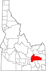
Bingham County, Idaho Basics:


Bingham County Idaho - Government Site

Population: 45,466
Area: 2094 square miles
County seat: Blackfoot
Area code(s) in use: 208
Time zone: MST
High school graduate or higher: 84.9%
Bachelor's degree or higher: 17.4%
Median household income: $46,817
Persons in poverty: 15.4%
Home ownership rate: 76.5%
Mean travel time to work: 20.7 minutes


Adjacent counties:
Bannock  Blaine  Bonneville  Butte  Caribou  Jefferson  Power  
Find in Idaho

Map of the Bingham County area


Our detail map of Bingham County shows the Bingham County, Idaho boundary lines and other interesting items.

Places in Bingham County, Idaho

  Airports     show all on map

Aberdeen Municipal Airport, McCarley Field, Midway Airport, Rockford Municipal Airport, Russell W Anderson Strip

  Areas     show all on map

Hells Half Acre, Rising River, The Cove

  Basins     show all on map

Buckskin Basin, Commissary Basin, Danielson Basin, Dunn Basin, High Basin, Pack Saddle Basin, Sage Hen Basin, Saw Log Basin, The Basin

  Bays     show all on map

Big Hole, Little Hole

  Bridges     show all on map

Bennett Bridge, Morgan Bridge, Pole Bridge, Porterville Bridge, Shelley Bridge, Tilden Bridge, Trail Creek Bridge

  Buildings     show all on map

Aberdeen - Springfield Fire Department, Aberdeen - Springfield Fire Department, Aberdeen Police Department, Atomic City Fire Department Mobile Unit, Bingham County Sheriff's Office, Blackfoot Fire Department Station 1, Blackfoot Fire Department Station 2, Blackfoot Police Department, Fort Hall Fire and Emergency Medical Services District, Idaho National Laboratory Safety Department Station 2, Shelley Firth Fire District, Shelley Firth Fire District, Shelley Police Department

  Canals     show all on map

Aberdeen Springfield Canal, Aberdeen Wasteway Canal, Ace Lateral, Agency Lateral, Allens Branch, Apex Lateral, Arc Lateral, Arch Lateral, Arrow Lateral, Ash Lateral, Augustine Ditch, Ballard Ditch, Bell Lateral, Blackfoot Canal, Blackfoot Slough, Bow Lateral, Calico Lateral, Cash Lateral, Cedar Point Canal, Centerville Ditch, Centerville Ditch, Central Ditch, Christenson Lateral, Cooley Lateral, Corbett Slough Canal, Cox Lateral, Crawford Ditch, Danskin Canal, Divide Ditch, Dixie Lateral, Dubois Lateral, Duncan Ditch, Early Lateral, East Branch Blackfoot Canal, East Branch Snake River Valley Canal, Ebony Lateral, Echo Lateral, Edge Lateral, Egg Lateral, Eldridge Lateral, Elite Lateral, Enders Lateral, Engdahl Lateral, England Lateral, English Lateral, Ensign Lateral, Evans Lateral, Express Lateral, Flood Channel, Fort Hall Main Canal, Fred Lateral, Fremont Lateral, Gibson Canal, Golden Lateral, Great Western Canal, Hanson Ditch, Highline Canal, Highline Canal, Highline Ditch, IR Ditch, Jensen Lateral, Jones Ditch, Jones Lateral, Just Canal, Kearney Canal, Larson Lateral, Lateral 45, Lateral 46, Lateral A, Lateral B, Lateral C, Lateral C 1, Lateral C 5, Lateral C2, Lateral C3, Lateral D, Lateral D 1, Lateral E, Lateral E 1, Lateral F, Lateral F 1, Lateral G, Lateral H, Lateral I, Lateral J, Lateral K, Lateral N, Lateral O, Lateral P, Lateral T, Lateral V, Lateral V 1, Lateral V-2, Lateral V-3, Lateral X, Lateral Y, Lateral Y-1, Lateral Y-2, Lateral Y-3, Lateral Z, Lindsey Lateral, Little Butte Canal, Little Indian Ditch, Littlejohn Lateral, Lloyd Ditch, Low Line Canal, Lower Holmes Canal, Main Spill, Marlow Lateral, Metz Ditch, Monson Lateral, Nadine Lateral, Nadir Lateral, Nazarre Lateral, Nebo Lateral, Nectar Lateral, Neon Lateral, Neptune Lateral, Neva Lateral, New Lateral, New Lavaside and People Canal, New Lavaside Ditch, Newell Lateral, Nile Lateral, Nomad Lateral, Nora Lateral, North Canal, Parker Lateral, Peoples Canal, Quigg Lateral, Reservation Canal, Riverton Ditch, Rockford Canal, Ross Fork Wasteway, Shull Lateral, Snake River Valley Canal, Southtown Ditch, Steel Lateral, Stevens Ditch, Taylor Ditch, Teak Lateral, The Slough, Town Lateral, Townsend Lateral, Township Lateral, Townsite Lateral, Trego Ditch, Trego Lateral, Turner Lateral, Warnett Lateral, Waste Ditch, Wearyrick Ditch, Weggland Ditch, Wenee Ditch, West Branch Blackfoot Canal, West Branch Snake River Valley Canal, West Side Ditch, Woodville Canal, Younnie Ditch

  Cemeteries     show all on map

Basalt Cemetery, Gibson Cemetery, Good Shepherd Cemetery, Grove City Cemetery, Groveland Cemetery, Hillcrest Cemetery, Homestead Cemetery, Moreland Cemetery, Riverview Cemetery, Ross Fork Cemetery, Thomas Riverside Cemetery

  Census     show all on map

Groveland Census Designated Place, Moreland Census Designated Place, Riverside Census Designated Place, Rockford Census Designated Place

  Craters     show all on map

Cinder Pit

  Crossings     show all on map

Four Corners

  Dams     show all on map

Blackfoot-Equalizing Dam, Twin Buttes Number One Dam

  Flats     show all on map

Alkali Flat, Cranes Flat, Crooked Creek Flat, Morgans Pasture, Tractor Flat, Wilson Flat

  Gaps     show all on map

Double W Divide, Lemhi Pass, Moses Pass, Tanner Pass, The Narrows

  Hospitals     show all on map

Bingham Memorial Hospital, Idaho Doctors Hospital, State Hospital South

  Islands     show all on map

Poison Creek Island

  Lakes     show all on map

Cottontail Waterhole, Equalizing Reservoir, Jensens Lake, Lau Lakes, Meteor Hole, Rat Lake, Wood Road Lake

  Lava     show all on map

Willow Creek Lava Field

  Locales     show all on map

Argonne West, Association Corral, Cox, Eagle Lodge, Eastern State Fairgrounds, Ferry Butte Access Area, Fort Hall Indian Agency, Fort Hall Number 2 Historic Site, Gem State Access Area, Grave Creek Campground, Hancock Ranch, Hansen Corral, Neil Ranch, Pingree Access Area, Poison Creek Boat Ramp, Riverton Access Area, Sagehen Campground, Springfield Lake Access Area, Taylor Mountain Ski Area, Westvaco, Willow Creek and Seventy Creek Access Areas

  Mines     show all on map

Gay Mine, Westvaco Mine

  Parks     show all on map

Airport Park, Jensen Grove Park, Springfield Bird Haven

  Pillars     show all on map

White Rock

  Populated Places     show all on map

Aberdeen, Aberdeen Junction, Aiken, Alridge, Atomic City, Basalt, Blackfoot, Cerro Grande, Clarkson, Coffee Point, Collins, Cox, Fingal, Firth, Fort Hall, Fullmer, Gay, Gibson, Goshen, Goshen Junction, Grandview, Groveland, Havens, Kimball, Liberty, McDonaldville, Mitchell, Moreland, Morgan, Olsen, Peterson (historical), Pingree, Rising River, Riverside, Rockford, Rose, Rouse, Shelley, Springfield, Sterling, Taber, Thomas, Trailton (historical), Wapello, Wolverine, Woodville

  Post Offices     show all on map

Payne Post Office (historical), Trailton Post Office (historical)

  Ranges     show all on map

Blackfoot Mountains, Paradise Hills, Three Buttes

  Reserves     show all on map

Sterling Wildlife Management Area

  Reservoirs     show all on map

Big Fill Reservoir, Camp Four Reservoir, Coffee Point Reservoir, Cow Pasture Reservoir Number 1, Cow Pasture Reservoir Number 2, Dry Wash Reservoir, Duck Lake Reservoir, Eagle Reservoir, Equalizing Reservoir, Grover Lake Reservoir, Lava Lake Reservoir, Moose Reservoir, Parleys Reservoir, Ripples Reservoir, Robison Reservoir, Rye Grass Reservoir, Sauce Pan Reservoir, Sheep Lake Reservoir, Well Number 2 Reservoir

  Ridges     show all on map

Blue Ridge, Lemhi Ridge, Outlet Ridge, Wilson Ridge

  Schools     show all on map

A W Johnson Elementary School, Aberdeen Elementary-Middle School, Aberdeen High School, Blackfoot High School, Dawn Enterprise Incorporated, Dean Goodsell Primary School, Donald J Hobbs Middle School, Elmwood School, Firth High School, Fort Hall Elementary School, Groveland Elementary School, Harding Gibbs Middle School, Hazel Stuart Elementary School, I T Stoddard Elementary School, Irving Kindergarten Center, Jameston School, Lavaside School, Moreland Elementary School, Mountain View Middle School, Pingree Elementary School, Riverside Elementary School, Riverview School, Ross Fork Indian School, Second Chance Project Alternative High School, Shelley Junior High School, Shelley Senior High School, Shilling Elementary School, Snake River High School, Snake River High School (historical), Snake River Junior High School, Snake River Junior High School (historical), Snake River Middle School, Stalker Elementary School, Stanton School, Wapello Elementary School

  Springs     show all on map

Big Willow Spring, Bronco Spring, Buckskin Spring, Butler Spring, Cedar Spring, Cold Spring, Cove Spring, Covered Springs, Cow Spring, Cowboy Spring, Coyote Spring, Dixey Spring, Dynamite Spring, Empey Spring, Gold Spring, Heaton Spring, Lincoln Peak Spring, Lone Pine Spring, Long Valley Spring, Lower Spring, Martin Spring, Mud Spring, Qeedup Spring, Queedup Spring, Rawhide Spring, Red Rock Spring, Rock Spring, Upper Spring, Warm Spring, White Rock Spring, Yandell Springs

  Streams     show all on map

Alley Lyons Creek, Beaver Creek, Blackfoot River, Brush Creek, Buck Creek, Bull Creek, Carter Creek, Cedar Creek, Cedar Creek, Chicken Creek, Cold Creek, Cole Creek, Colt Creek, Crane Creek, Crooked Creek, Deadman Creek, Deer Creek, Deer Creek, Dry Miner, Evert Creek, Garden Creek, Garden Creek, Grave Creek, Hancock Creek, Homer Creek, Horse Creek, Horse Creek, Indian Creek, Jeff Cabin Creek, Jim Creek, Jones Creek, King Creek, Lava Creek, Levi Hawkley Creek, Lincoln Creek, Little Sand Creek, Long Valley Creek, Mackelroy Creek, Menassa Creek, Middle Creek, Mill Creek, Miner Creek, Mud Creek, North Fork Cold Creek, Pack Saddle Creek, Paradise Creek, Poison Creek, Poison Creek, Rawlins Creek, Red Rock Creek, Reed Creek, Sand Creek, Sellars Creek, Seventy Creek, Sheep Creek, Short Creek, South Fork Cold Creek, South Fork Ross Fork, South Fork Sellars Creek, Spring Creek, Spring Creek, Strawberry Creek, Sunday Creek, Supon Creek, Trail Creek, Watson Slough, West Fork Crooked Creek, Wham Creek, Wilson Creek, Wilson Creek, Wolverine Creek, Wood Creek

  Summits     show all on map

Baldy Knoll, Birch Creek Mountain, Cedar Butte, Dare Peak, East Butte, Ferry Butte, Garden Peak, Higham Peak, Hyram Butte, Lincoln Peak, Little Butte, Meadow Creek Mountain, Middle Butte, Mollies Nipple, Pine Mountain, Sheep Mountain, Stevens Peak, Sugarloaf Mountain, Table Legs Butte, Taylor Mountain, The Butte, The Saddle, Twin Buttes, Yandell Mountain, Ziegler Mountain

  Towers     show all on map

KBLI-AM (Blackfoot), KIDK-TV (Idaho Falls), KIFI-TV (Idaho Falls), KISU-TV (Pocatello), KSIF-FM (Idaho Falls)

  Trails     show all on map

Portneuf Presto Trail

  Valleys     show all on map

Bakers Canyon, Dry Hollow, Homer Valley, Lincoln Corral Canyon, Lincoln Creek Valley, Little Hole Draw, Lone Pine Canyon, Long Valley, Paradise Valley, Rabbit Hollow, Rattlesnake Canyon, Sage Hen Draw, Smiley Canyon, Wolverine Canyon

  Wells     show all on map

Dry Hollow Well, Leo Rogers Well, Number 1 Well, Number 2 Well, Well Number 3,

Bingham County, Idaho Population By Race (2012 estimate)

RacePopulation
WhiteBingham County White population 40,82840,828  
American IndianBingham County American Indian population 3,2283,228
MixedBingham County Mixed population 818818
AsianBingham County Asian population 318318
BlackBingham County Black population 227227
Hawaiian & Pacific IslanderBingham County Hawaiian & Pacific Islander population 4545

Additional population tables :
State population table
Idaho population by county