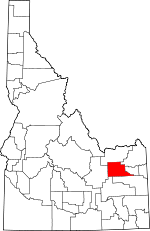
Jefferson County, Idaho Basics:


Jefferson County Idaho - Government Site

Population: 26,699
Area: 1094 square miles
County seat: Rigby
Area code(s) in use: 208
Time zone: MST
High school graduate or higher: 88.6%
Bachelor's degree or higher: 21.2%
Median household income: $52,980
Persons in poverty: 11.0%
Home ownership rate: 82.7%
Mean travel time to work: 24.7 minutes


Adjacent counties:
Bingham  Bonneville  Butte  Clark  Fremont  Madison  
Find in Idaho

Map of the Jefferson County area


Our detail map of Jefferson County shows the Jefferson County, Idaho boundary lines and other interesting items.

Places in Jefferson County, Idaho

  Airports     show all on map

Mud Lake Airport, Q B One Airport, Rigby Airport

  Bends     show all on map

Tie Bend

  Buildings     show all on map

Central Fire District Station 1, Central Fire District Station 2, Central Fire District Station 3, Central Fire District Station 4, Hamer Fire Department, Jefferson County Sheriff's Office, Mud Lake Ambulance, Roberts Fire District, West Jefferson Fire Control District Station 1, West Jefferson Fire Control District Station 2

  Canals     show all on map

Alliance Canal, Bell Larsen Canal, Big Six Canal, Bungalow Canal, Burgess Canal, Butte Market Lake Canal, Clark Edwards Canal, Crystal Lake Canal, Deer Park Canal, Eagle Rock Canal, East Canal, East Labelle Canal, Enterprise Canal, Farmers Friend Canal, Hamer Ditch, Harrison Canal, Holly Canal, Independent Canal, Independent Ditch, Island Canal, Jackett Canal, Jefferson Canal, Long Island Canal, McCarthy Ditch, McKevitt Ditch, Miller Canal, Missionary Canal, Mitchell Ditch, North Lake Canal, North Parks Lewisville Canal, North Rigby Canal, North Rudy Canal, Owsley Canal, Park and Lemon Canal, Parks Lewisville Canal, Poitevin Ditch, Rays Lake Canal, Rigby Canal, Rigby Waste, Robison Canal, Rudy Canal, Scotts Slough Canal, Second Owsley Canal, Selck and Taylor Canal, Severson Canal, Sidehill Ditch, South Parks Lewisville Canal, South Rigby Canal, Vance Payne Canal, Wilkins Canal

  Cemeteries     show all on map

Central Cemetery, Lewisville Cemetery

  Churches     show all on map

Clark Ward Church

  Dams     show all on map

Idaho Diversion Dam, Mud Lake Dam

  Flats     show all on map

Deer Parks

  Guts     show all on map

Market Lake Slough

  Islands     show all on map

Butler Island, Kellers Island

  Lakes     show all on map

Butte Slough, Hamer Lake, Leavitz Pond, Mallard Slough, Muskrat Pond, North Lake, Oxbow Slough, Rat Farm Pond, Roberts Slough, Rock Lakes, Taylor Slough, Two-way Pond, Willow Pond

  Locales     show all on map

Camas National Wildlife Refuge Headquarters, Kelly Canyon Ski Area, Rays Lake Pump

  Parks     show all on map

Camas National Wildlife Refuge, Market Lake Wildlife Management Area

  Pillars     show all on map

Bertha Rock, Blanche Rock

  Populated Places     show all on map

Annis, Barlow, Bassett, Camas, Garfield, Grant, Hamer, Hawgood, Heise, Labelle, Level (historical), Lewisville, Lorenzo, Menan, Midway, Monteview, Mud Lake, Rigby, Ririe, Roberts, Rudy, Sage Junction, Terreton

  Ranges     show all on map

Lewisville Knolls, The Breaks

  Reserves     show all on map

Mud Lake Wildlife Management Area

  Reservoirs     show all on map

Jefferson Reservoir, Johnston Lake, Market Lake, Mud Lake, Rays Lake, Sandhole Lake

  Ridges     show all on map

Little Grassy Ridge

  Schools     show all on map

Clark School, Garfield School, Grant School, Hamer Elementary School, Harwood Elementary School, Kinghorn Elementary School, Midway Elementary School, Midway High School (historical), Midway Middle School, Rigby Junior High School, Rigby Senior High School, Ririe Elementary School, Ririe Junior-Senior High School, Roberts Elementary School, Roberts Middle School, West Jefferson High School

  Springs     show all on map

East Springs, Hawley Warm Spring, Heise Hot Springs, Hot Springs

  Streams     show all on map

Annis Slough, Beaver Creek, Camas Creek, Dry Bed, Emigrant Creek, Kettle Butte Drain, Lowder Slough, Scotts Slough, Spring Creek, Warm Creek

  Summits     show all on map

Antelope Butte, Beacon Butte, Bunker Hill, Camas Butte, Circular Butte, Clay Butte, Little Buttes, Mollys Nipple, Needle Butte, Raumaker Butte, Sand Mountain, Table Butte

  Towers     show all on map

KRIC-FM (Rexburg)

  Valleys     show all on map

Kelly Canyon

  Wells     show all on map

Buck Springs Wells, Holly Wells, Owsley Wells, Table Butte Well,

Jefferson County, Idaho Population By Race (2012 estimate)

RacePopulation
WhiteJefferson County White population 25,71125,711  
MixedJefferson County Mixed population 400400
American IndianJefferson County American Indian population 347347
AsianJefferson County Asian population 133133
BlackJefferson County Black population 8080
Hawaiian & Pacific IslanderJefferson County Hawaiian & Pacific Islander population 2726

Additional population tables :
State population table
Idaho population by county