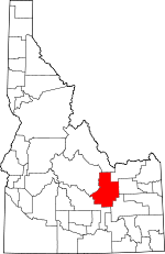
Butte County, Idaho Basics:


Butte County Idaho - Government Site

Population: 2,738
Area: 2232 square miles
County seat: Arco
Area code(s) in use: 208
Time zone: MST
High school graduate or higher: 91.5%
Bachelor's degree or higher: 17.9%
Median household income: $40,150
Persons in poverty: 14.3%
Home ownership rate: 81.2%
Mean travel time to work: 17.7 minutes


Adjacent counties:
Bingham  Blaine  Clark  Custer  Jefferson  Lemhi  
Find in Idaho

Map of the Butte County area


Our detail map of Butte County shows the Butte County, Idaho boundary lines and other interesting items.

Places in Butte County, Idaho

  Airports     show all on map

Antelope Valley Airport, Arco Airport, Big Southern Butte Airport, Howe Airport, Quaking Aspen Butte Landing Strip

  Arches     show all on map

Bridge of Tears

  Bars     show all on map

Badger Creek Bar, Deer Creek Bar, Mulky Bar, Sunny Bar

  Basins     show all on map

Big Lost River Sinks, Big Sink, Birch Basin, Birch Creek Sinks, Blizzard Basin, Crystal Pit, Huddles Hole, Huddles Hole, Little Basin, Little Lost River Sinks, Wet Creek Basin

  Buildings     show all on map

Arco Fire Department Business Office, Butte County Sheriff's Office, Idaho National Laboratory Safety Department Station 1, Idaho National Laboratory Safety Department Station 3, Lost River Fire District

  Canals     show all on map

Arco Canal, Beck and Evan Ditch, Blaine Canal, Burnett Ditch, East Side Ditch, Fury Ditch, Island Ditch, Lower Blaine Canal, Martins Ditch, Moore Canal, Munsey Ditch, Telford Pipe, Three in One Ditch

  Cemeteries     show all on map

Antelope Cemetery, Hillcrest Cemetery, Lost River Cemetery

  Craters     show all on map

Big Craters, Echo Crater, North Crater

  Dams     show all on map

Moore Diversion

  Flats     show all on map

Deer Flats, Little Prairie, Ryegrass Flat, Trench Mortar Flat

  Gaps     show all on map

Beaverland Pass, Deer Creek Pass

  Hospitals     show all on map

Lost Rivers District Hospital

  Lakes     show all on map

Bearsden Waterhole, Big Lake, Big Sink Waterhole, Cottontail Waterhole, Coyote Water Hole, Doves Waterholes, Fingers Butte Reservoir, Little Prairie Waterhole, Pass Creek Lake, Pratt Lake, Rocky Lake, Rocky Point Water Hole, Sage Brush Reservoir, Sunset Lake, Surprise Waterhole, Tin Cup Lake, Yellowjacket Waterhole

  Lava     show all on map

Big Craters Flow, Black Flow, Blue Dragon Flow, Buffalo Caves Flow, Crystal Fissure Flow, Derelict Flow, Devils Orchard, Lava Cascades, Little Prairie Aa Flow, North Crater Aa Flow, North Crater Flow, Sawtooth Flow, Sentinel South Flow, Serrate Flow

  Locales     show all on map

Antelope Creek Access Area, Bell Mountain Ranger Station, Blizzard Mountain Ski Area, Brockie Ranch, Fallert, Frenchmans Cabin, Little Lost River Access Area, Little Lost Ski Area, Soelberg Ranch, Tunnel Cabin

  Mines     show all on map

Badger Mine, Ella Mine, Golden Chariot Mine, Hub Mine, Last Chance Mine, Martin Mine, Oxide Lode Mine, Reliance Mine, Saint Louis Mine, Silver Bell Mine, Tepee Circles, Valley Arco Mine, Valley View Mine

  Parks     show all on map

Bottolfsen Park, Craters of the Moon National Monument

  Pillars     show all on map

Cave Rock, The Needles

  Populated Places     show all on map

Antelope (historical), Arco, Berenice, Butte City, Clyde, Darlington, Era, Howe, Lost River, Martin, Moore, Scoville, Smith Corrals, Sweet Sage (historical)

  Ranges     show all on map

Arco Hills, Hawley Mountains, Lost River Range

  Reserves     show all on map

Craters of the Moon National Wilderness Area, Idaho National Engineering Laboratory

  Reservoirs     show all on map

Big Butte Reservoir, Big Butte Reservoir Number Two, Combe Reservoir, Harold Reservoir, Heifer Reservoir, Mud Lake, Muddy Reservoir, Nichols Reservoir, Parson Reservoir, Quaking Aspen Reservoir, Twin Lakes, West Side Reservoir

  Ridges     show all on map

Lava Ridge, Sunset Ridge

  Schools     show all on map

Arco Elementary School, Butte County High School, Butte County Middle School, Grouse School, Howe Elementary School

  Springs     show all on map

Big Buck Spring, Big Spring, Blind Springs, Cold Spring, Coyote Spring, Fallert Springs, Fowler Springs, Frenchmans Spring, King Spring, Kyle Spring, Little Cottonwood Springs, Mud Spring, Sorenson Spring, Squaw Springs, Techick Spring, Walker Spring, Webb Spring, Willow Springs

  Streams     show all on map

Antelope Creek, Badger Creek, Basin Creek, Bell Mountain Creek, Big Lost River, Big Spring Creek, Birch Creek, Black Creek, Boulder Creek, Boyle Creek, Cabin Creek, Cabin Fork, Camp Creek, Camp Creek, Cedar Run Creek, Champagne Creek, Deep Creek, Deer Creek, Deer Creek, Dry Channel Big Lost River, Dry Creek, Dry Fork Creek, Ferris Slough, Hammond Spring Creek, Hooley Creek, Horse Creek, Horsethief Creek, Hurst Creek, James Creek, Lava Creek, Leadbelt Creek, Little Cottonwood Creek, Little Lost River, Lower Pass Creek, Middle Fork Kyle Canyon, Middle Fork Pass Creek, North Creek, North Fork Cabin Fork, North Fork Deer Creek, North Fork Pass Creek, Pass Creek, Pine Creek, Pine Creek, Rocky Run Creek, Slim Creek, South Creek, South Fork Antelope Creek, South Fork Deer Creek, South Fork Kyle Canyon, South Fork Pass Creek, South Lava Creek, Spring Creek, Spring Creek, Squaw Creek, Timbered Dome Creek, Trail Creek, Trail Creek, Uncle Ike Creek, Wagon Box Creek, Warm Spring Creek, Wet Creek, Williams Creek

  Summits     show all on map

Appendicitis Hill, Arco Peak, Bell Mountain, Big Butte, Big Cinder Butte, Big Southern Butte, Black Cap, Black Cap Peak, Broken Top, Coyote Butte, Coyote Butte, Crescent Butte, Cruthers Butte, Diamond Peak, Fingers Butte, Foss Mountain, Grassy Cone, Half Cone, Hawley Mountain, Howe Peak, Inferno Cone, Jumpoff Peak, King Mountain, Paisley Cone, Pass Creek Summit, Pratt Butte, Quaking Aspen Butte, Richard Butte, Rock Butte, Rock Corral Butte, Round Knoll, Saddle Butte, Saddle Mountain, Serviceberry Butte, Silent Cone, Sixmile Butte, Snow Cone, Sunset Cone, Sunset Peak, Teakettle Butte, The Sentinel, The Watchman, Timbered Dome, Tin Cup Butte, Wildhorse Butte

  Tunnels     show all on map

Indian Tunnel, Tom Thumb Tunnel

  Valleys     show all on map

Anderson Canyon, Antelope Valley, Bartel Canyon, Basinger Canyon, Beck Canyon, Berry Canyon, Big Burnett Canyon, Big Lost River Valley, Bighorn Canyon, Bird Canyon, Black Canyon, Black Tail Canyon, Boulder Canyon, Box Canyon, Braithwaite Canyon, Brier Canyon, Briggs Canyon, Buck Canyon, Bunting Canyon, Cave Gulch, Cedar Canyon, Cedar Run Canyon, Cedarville Canyon, Chicken Canyon, Clark Canyon, Cold Spring Canyon, Combe Canyon, Corral Canyon, Deadman Canyon, Deer Canyon, East Canyon, Eightmile Canyon, Elbow Canyon, Graveyard Canyon, Hammond Canyon, Hawley Canyon, Horsethief Canyon, Hurst Canyon, Hurst Canyon, Jack Wright Canyon, Jaggles Canyon, Jepson Canyon, Jumpoff Canyon, King Canyon, Kyle Canyon, Larkspur Canyon, Latham Hollow, Left Fork Eightmile Canyon, Left Fork Rocky Canyon, Limekiln Canyon, Little Burnett Canyon, Little Chokecherry Canyon, Little Lost River Valley, Maddock Canyon, Middle Canyon, Mormon Gulch, Mud Lake Canyon, Newman Canyon, Poison Gulch, Price Canyon, Price Canyon, Ramshorn Canyon, Right Fork Eightmile Canyon, Right Fork Rocky Canyon, Right Fork Sawmill Canyon, Rocky Canyon, Rocky Canyon, Saint Louis Canyon, Sands Canyon, Sawmill Canyon, Sawmill Canyon, Sawmill Canyon, Sixmile Canyon, Slaughterhouse Canyon, South Fork Meadow Canyon, Stoddard Gulch, Sunny Bar Canyon, Sutton Canyon, Taylor Canyon, Van Dorn Canyon, Walker Canyon, Wood Canyon

  Wells     show all on map

Crossroad Well, Fingers Butte Well, Sunset Well,

Butte County, Idaho Population By Race (2012 estimate)

RacePopulation
WhiteButte County White population 2,6452,644  
MixedButte County Mixed population 5252
American IndianButte County American Indian population 1616
BlackButte County Black population 1110
AsianButte County Asian population 88
Hawaiian & Pacific IslanderButte County Hawaiian & Pacific Islander population 55

Additional population tables :
State population table
Idaho population by county