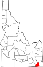
Franklin County, Idaho Basics:


Franklin County Idaho - Government Site

Population: 12,805
Area: 664 square miles
County seat: Preston
Area code(s) in use: 208
Time zone: MST
High school graduate or higher: 91.8%
Bachelor's degree or higher: 18.0%
Median household income: $47,598
Persons in poverty: 11.8%
Home ownership rate: 81.7%
Mean travel time to work: 23.0 minutes


Adjacent counties:
Bannock  Bear Lake  Box Elder (UT)  Cache (UT)  Caribou  Oneida  Rich (UT)  
Find in Idaho

Map of the Franklin County area


Our detail map of Franklin County shows the Franklin County, Idaho boundary lines and other interesting items.

Places in Franklin County, Idaho

  Airports     show all on map

Preston Airport

  Areas     show all on map

Falls

  Basins     show all on map

Clifton Basin, Cub Basin, Davis Basin, Dry Basin, Egan Basin, Franklin Basin, Gibson Basin, Horse Basin, Litz Basin, North Worm Creek Basin, Oxford Basin, Red Sinks, South Worm Creek Basin, The Sinks

  Bridges     show all on map

McGregors Bridge

  Buildings     show all on map

Franklin County Fire Protection District, Franklin County Fire Protection District Station 2, Franklin County Sheriff's Office, Preston Police Department

  Canals     show all on map

Cleveland Irrigation Canal, Cub Canal, Cub River Worm Creek Canal, East Canal, Lower Canal, Middle Ditch, Mink Creek Canal, Preston Riverdale Canal, Treasureton Canal, Twin Lakes Canal, Twin Lakes Canal East Lateral, Twin Lakes Canal West Lateral, Upper Canal, West Cache Canal, West Canal

  Cemeteries     show all on map

Cleveland Cemetery, Fairview Cemetery, Franklin Cemetery, Oxford Cemetery, Preston Cemetery, Treasureton Cemetery, Whitney Cemetery

  Dams     show all on map

Andreason Number Three Dam, Casperson Dam, Condie Dam, Five Mile Erosion Control Dam, Foster Dam, Glendale Dam, Hinkley Dam, Johnson Dam, Lamont Dam, Le Fevre Dam, Morrison Dam, Nash Dam, Nielson Dam, Oneida Dam, Oxford Dam, Stock Valley Dam, Strongarm Reservoir Number One Dam, Strongarm Reservoir Number Two Dam, Tingey Dam, Twin Lakes Northwest Dam, Twin Lakes Southwest Dam, Van Orden Dam, Winder Dam

  Flats     show all on map

Cherryville Flat, Indian Flat, Poverty Flats, Willow Flat

  Gaps     show all on map

Beers Spur, Danish Pass

  Hospitals     show all on map

Franklin County Medical Center

  Lakes     show all on map

Big Creek Lake, Blue Lake, Gibson Lakes, Hidden Lake, Horse Lake, Wiggler Lake

  Locales     show all on map

Albert Moser Campground, Beaver Creek Campground, Camp Wilderness, Cloverleaf Campground, Club River Guard Station, Dayton Siding, Foster Reservoir Access Area, Glendale Reservoir Access Area, Hale Mine, Little Santa Anita Racetrack, Oneida Station, Porcupine Campground, Twin Lakes Access Area

  Parks     show all on map

Pioneer Women Historical Monument

  Pillars     show all on map

Standing Rock

  Populated Places     show all on map

Anderson, Banida, Cherryville, Cleveland, Clifton, Coulam, Dayton, Egypt, Fairview, Franklin, Glendale, Mapleton, Mink Creek, Mound Valley, Nashville, Oxford, Preston, Riverdale, Silver Star, Thatcher, Thorenson, Treasureton, Weston, Whitney, Winder

  Reservoirs     show all on map

Condie Reservoir, Foster Reservoir, Glendale Reservoir, Johnson Reservoir, Lamont Reservoir, Oneida Narrows Reservoir, Oxford Reservoir, Strong Arm Reservoir, Strongarm Reservoir Number One, Treasureton Reservoir, Twin Lakes Reservoir, Winder Reservoir

  Ridges     show all on map

Morgan Ridge, Oxford Ridge

  Schools     show all on map

Central High School (historical), Central School, Harold B Lee Elementary School, Jefferson Junior High School, Jefferson School, Oakwood Elementary School, Pioneer Elementary School, Preston High School, Strawberry Creek School (historical), Thatcher Elementary School, West Side High School, Whitney School

  Springs     show all on map

Alpine Spring, Aspen Spring, Aspen Spring, Baker Spring, Balsam Spring, Bear Wallow Spring, Bergguist Spring, Budge Spring, Burbank Spring, Chatterton Spring, Cold Spring, Corner Spring, Crib Spring, Croney Hollow Spring, Cub Basin Spring, Dock Spring, Graham Hollow Spring, Hells Kitchen Spring, Hillyard Spring, Horse Basin Spring, Indian Spring, Litz Spring, Log Spring, Lost Spring, Main Canyon Spring, Maple Grove Hot Springs, Maple Spring, Mink Creek Spring, Paul Jones Spring, Peterson Hollow Spring, Pine Corral Spring, Pine Spring, Pipeline Spring, Post Hollow Spring, Rocky Bench Spring, Sawmill Spring, Self Help Spring, Sink Spring, Slate Rock Spring, Squaw Springs, Strawberry Spring, Thimbleberry Spring, Thomas Spring, Thorne Spring, Tie Camp Spring, Wayland Hot Springs, Williams Creek Spring, Worm Basin Spring

  Streams     show all on map

Battle Creek, Bear Creek, Birch Creek, Carter Creek, Clifton Creek, Cottonwood Creek, Crooked Creek, Davis Creek, Deep Creek, Dry Creek, Fivemile Creek, Flat Canyon, Foster Creek, Hodge Nibley Creek, King Creek, Kuntz Creek, Left Fork Maple Creek, Litz Creek, Maple Creek, Michael Creek, Middle Fork Saint Charles Creek, Mink Creek, North Fork Saint Charles Creek, Oxford Creek, Right Fork Williams Creek, Sant Creek, South Fork Dry Creek, South Fork Saint Charles Creek, Spring Creek, Station Creek, Strawberry Creek, Sugar Creek, Trout Creek, Weston Creek, Williams Creek

  Summits     show all on map

Andrew Nyman Mountain, Big Hill, Buck Peak, Cleveland Hill, Devils Hill, Dirty Head, Little Mountain, Little Mountain, Old Baldy Peak, Oxford Peak, Rocky Knoll, Rocky Peak, Thatcher Hill, Treasureton Hill, Weston Peak, Wilderness Peak

  Swamps     show all on map

Oxford Slough

  Towers     show all on map

KACH-AM (Preston)

  Trails     show all on map

Bloomington Lake Trail, High Line Trail

  Tunnels     show all on map

Station Creek Tunnel

  Valleys     show all on map

Bear Hollow, Boss Canyon, Corral Hollow, Croney Hollow, Fox Hollow, Graham Hollow, Hillyard Canyon, Hull Valley, Main Canyon, Mass Canyon, Mill Canyon, Mill Canyon, Mill Hollow, Mine Hollow, Mound Valley, Oneida Narrows, Oxkiller Canyon, Pat Hollow, Peterson Hollow, Porcupine Hollow, Post Hollow, Relief Society Hollow, Rockslide Canyon, Schoolhouse Hollow, Self Help Hollow, Sheep Dip Hollow, Snow Hollow, Snowslide Canyon, South Canyon, South Canyon, Spring Flat Canyon, Spring Hollow, Squirrel Hollow, Stock Valley, Strawberry Canyon, Weston Canyon, White Canyon, Williams Canyon,

Franklin County, Idaho Population By Race (2012 estimate)

RacePopulation
WhiteFranklin County White population 12,48512,484  
MixedFranklin County Mixed population 166166
American IndianFranklin County American Indian population 102102
BlackFranklin County Black population 3838
Hawaiian & Pacific IslanderFranklin County Hawaiian & Pacific Islander population 1312

Additional population tables :
State population table
Idaho population by county