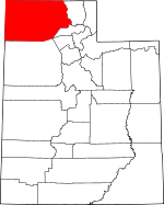
Box Elder County, Utah Basics:


Box Elder County Utah - Government Site

Population: 50,232
Area: 5746 square miles
County seat: Brigham City
Area code(s) in use: 435
Time zone: MST
High school graduate or higher: 91.3%
Bachelor's degree or higher: 21.7%
Median household income: $55,918
Persons in poverty: 8.5%
Home ownership rate: 80.3%
Mean travel time to work: 23.2 minutes


Adjacent counties:
Cache  Cassia (ID)  Elko (NV)  Franklin (ID)  Oneida (ID)  Tooele  Weber  
Find in Utah

Map of the Box Elder County area


Our detail map of Box Elder County shows the Box Elder County, Utah boundary lines and other interesting items.

Places in Box Elder County, Utah

  Airports     show all on map

Bear River Valley Heliport, Brigham City Airport, Brigham City Community Hospital Heliport, Fort Ranch Airport, Hogup Pump Station Heliport, Howell Airport, Jack's Airport, Lakeside Heliport, Lucin Airport, Thiokol Airport

  Arches     show all on map

Aardvark Arch, Chinese Arch

  Areas     show all on map

Bighorn Enclosure, Devils Playground, Mouth of Bear River, Park Valley

  Arroyos     show all on map

Dry Fork Pine Creek, Right Fork Clear Creek

  Basins     show all on map

Balsam Basin, Clarks Basin, Deloris Basin, Dry Basin, Dry Canyon Basin, Faust Valley, Grouse Creek Sinks, Holt Basin, Kilgore Basin, Little Basin, Matlin Basin, Miners Basin, Mud Basin, Newfoundland Evaporation Basin, Peplin Flats, Sedal Valley, Sinks of Dove Creek, The Horseshoe, Upper Raft River Valley, Whites Valley, Willard Basin

  Bays     show all on map

Bear River Bay, Bristol Bay, Brownlee Bay, Carrington Bay, Clear Water Cove, Clyman Bay, East Bay, Homestead Bay, Indian Cove, Lambourne Bay, Little Bear Bay, North Bay, Pelican Bay, Phantom Bay, Rozel Bay, Seagull Bay, South Bay, South East Bay, Spring Bay, Stanley McGraw Bay, Vallery Bay, Willard Bay

  Bends     show all on map

Whistlers Bend

  Bridges     show all on map

Southern Pacific Causeway

  Buildings     show all on map

Alliant Techsystems Fire Station, Bel Mia Girls Home, Box Elder County Sheriff's Office, Brigham City Emergency Services Facility, Brigham City Police Department, Corinne Fire Department, Curlew Ambulance Service, Fielding Fire Department, Garland Fire Department, Garland Police Department, Grouse Creek Ambulance, Grouse Creek Fire Department, Hogup Pumping Station, Honeyville Fire Department, Mantua Volunteer Fire Department, Park Valley Fire Department, Perry Police Department, Plymouth Fire Department, Portage Fire and Rescue, Snowville Fire Department, Thatcher - Penrose Fire Department and Water Service District, Tremonton Fire Department Ambulance, Tremonton Police Department, Utah Highway Patrol Section 1 Brigham City Office, Willard City Fire Department and First Responders, Willard Police Department

  Canals     show all on map

Box Elder Canal, Central Canal, Corinne Canal, East Lateral, Hammond East Branch Canal, Hammond Main Canal, Hammond West Branch Canal, Highline Canal, Hull Canal, Kendall Canal, Mill Ditch, North String Irrigation Ditch, Perry Canal, Sulphur Creek Canal, West Canal, West Lateral, West Side Canal, Whistler Canal

  Capes     show all on map

Mushback Point, Pintail Neck, Pipeline Point, Pokes Point, Promontory Point

  Cemeteries     show all on map

Bear River Cemetery, Beaver Dam Cemetery, Bothwell Cemetery, Brigham City Cemetery, Clear Creek Cemetery, Corinne Cemetery, Deweyville Cemetery, East Garland Cemetery, Elwood Cemetery, Etna Cemetery, Fielding City Cemetery, Garland Cemetery, Grouse Creek Cemetery, Harper Ward Cemetery, Honeyville Cemetery, Howell Cemetery, Kelton Cemetery, Kimber Ranch Burial, Lynn Cemetery, Mantua Cemetery, Park Valley Cemetery, Park Valley Pioneer Cemetery, Penrose Cemetery, Perry Cemetery, Plymouth Cemetery, Portage Cemetery, Riverside Cemetery, Riverview Cemetery, Salt Creek Cemetery, Snowville Cemetery, Terrace Cemetery, Tyrell Cabin Burials, Valleyview Cemetery, Washakie Cemetery, Willard City Cemetery, Willard Pioneer Cemetery, Yost Cemetery

  Census     show all on map

Riverside Census Designated Place, South Willard Census Designated Place, Thatcher Census Designated Place

  Channels     show all on map

Bens Overflow, Blodgetts Overflow, Browns Overflow, East Pass, Fremont Strait, North Pass, Old River Channel, Rillas Overflow, Ship Channel, Willard Spur

  Churches     show all on map

Aldersgate United Methodist Church, Asemblea de Dios, Belmont Church, Brigham City Bible Church, Christian Reformed Church, Church of Christ, Community Presbyterian Church, First Baptist Church, Holy Cross Lutheran Church, La Hermosa Assembly, Saint Michaels Episcopal Church, The Church of Jesus Christ of Latter Day Saints, The Church of Jesus Christ of Latter Day Saints, The Church of Jesus Christ of Latter Day Saints, The Church of Jesus Christ of Latter Day Saints, The Church of Jesus Christ of Latter Day Saints, The Church of Jesus Christ of Latter Day Saints, The Church of Jesus Christ of Latter Day Saints, The Church of Jesus Christ of Latter Day Saints, The Church of Jesus Christ of Latter Day Saints, The Church of Jesus Christ of Latter Day Saints, The Church of Jesus Christ of Latter Day Saints, The Church of Jesus Christ of Latter Day Saints, The Church of Jesus Christ of Latter Day Saints, The Church of Jesus Christ of Latter Day Saints, The Church of Jesus Christ of Latter Day Saints, The Church of Jesus Christ of Latter Day Saints, The Church of Jesus Christ of Latter Day Saints, The Church of Jesus Christ of Latter Day Saints, The Church of Jesus Christ of Latter Day Saints, The Church of Jesus Christ of Latter Day Saints, The Church of Jesus Christ of Latter Day Saints, The Church of Jesus Christ of Latter Day Saints, The Church of Jesus Christ of Latter Day Saints, The Church of Jesus Christ of Latter Day Saints, The Church of Jesus Christ of Latter Day Saints, The Church of Jesus Christ of Latter Day Saints, The Church of Jesus Christ of Latter Day Saints, The Church of Jesus Christ of Latter Day Saints, The Church of Jesus Christ of Latter Day Saints, The Church of Jesus Christ of Latter Day Saints, The Church of Jesus Christ of Latter Day Saints, The Church of Jesus Christ of Latter Day Saints

  Cliffs     show all on map

Black Rocky Point, Coyote Point, Fish Fossil Rocks, Gunsight Point, Inspiration Point, Monument Point, Pleasant View Point, Point Lookout, Rosevere Point

  Crossings     show all on map

Interchange 354

  Dams     show all on map

Arthur V Watkins Dam, Cutler Dam, Dejarnatt Dam, Jackson Dam

  Flats     show all on map

Antelope Flat, Bear Flat, Buck Pasture, Bull Flat, Calf Flat, Dock Flat, Hogup Bar, Rocky Meadows, Rozel Flat, Salt Wells Flat, Squaw Flat, Swan Flat, The Hardpan, The Meadows, The Threshold

  Forests     show all on map

Sawtooth National Forest - Raft River Division

  Gaps     show all on map

Big Pass, Big Pass, Bulls Pass, Deans Pass, Devils Gate, Donner-Reed Pass, Dove Creek Pass, Emigrant Pass, Fixit Pass, Gillespie Pass, Ingham Pass, Kelton Pass, Kings Pass, Narrows of Dairy Valley, Patterson Pass, Promontory Summit, Rattlesnake Pass, Ridgedale Pass, Rocky Pass, Sedal Pass, Shelter Mountain Pass, Short Divide, Stewart Pass, Sunset Pass, The Narrows, Upper Narrows, Wrathall Pass

  Guts     show all on map

Appledale Slough

  Harbors     show all on map

Little Valley Harbor

  Hospitals     show all on map

Bear River Valley Hospital, Brigham City Community Hospital

  Islands     show all on map

Cub Island, Dolphin Island, Goose Island, Gunnison Island, Hat Island, Rock Island, The Knoll

  Lakes     show all on map

Cold Spring Lakes, Coyote Ponds, Dead River, Dike Lake, Fisher Lake, Glory Hole, Great Salt Lake, Gunnison Bay, Hansen Lake, Horseshoe Sloughs, Klondike Lake, Mallard Pond, Mueller Lake, Skating Pond, South Pond, Spring Lake, The Horseshoe

  Locales     show all on map

Allen (historical), Bar F Ranch, Bear River Duck Club, Beaver Dam, Beeton, Belmont Springs Campground, Beppo, Board Ranch, Bovine, Box Elder Campground, Box Elder Campground, Box Elder Picnic Grounds, Bridge, Brigham City Country Club, Brigham City KOA, Brigham City Shopping Center, Bush, C-Bar Ranch, Chesapeake Duck Club, Clear Creek, Clear Creek Campground, Clear Creek Campground, Crystal Spring Resort, Dipping Vat, Doutres Mobile Home Park, Duckville Gun Club, East Promontory, Fielding Siding, Ford, Groome, Haws Corner, Hershey Ranch, Jackson, James Brothers Ranch, Kimber Ranch, Kunzlers Ranch, Lambert Ranch, Lemay, Mantua Guard Station, Maple Creek Fish Hatchery, Morris Ranch, Morris Ranch, Mountain View Campground, Muddy Ranch, Newfoundland, North Recreation Area, Oasis, Ogden Gun Club, Old Stage Station, Olney (historical), Ombey, Onemile Guard Station, Palmer Ranch, Peplin, Perry Siding, Pilot Springs Stage Station, Pintail Gun Club, Promontory Point, Red Dome, Rose Ranch, Rosebud BLM Field Station, Rosebud Ranch, RV Acres Campground, Surbon, Teck (historical), Terrace, The Tenmile Place, Vern Steeds Ranch, Watercress, West Side Ranch, Willard Basin Campground, Willard Basin Trailhead, Willard Bay North Marina Campground, Willard Bay South Marina Campground, Willard Pumping Station Number 1, Youngs Corral

  Military     show all on map

Calls Fort (historical), Utah Test and Training Range-North

  Mines     show all on map

Alvarado Mine, American Mine, Baker Mine, Century Mine, Copper Blossom Mine, Dolly Clark Mine, Harrison Tunnel, Holton Mine, Lucin Pit, Peg Leg Mine, Skoro Mine, Vipont Mine, Workman Mine

  Oilfields     show all on map

Rozel Point Oil Field

  Parks     show all on map

Bear River Migratory Bird Refuge, Bear River National Migratory Bird Refuge (historical), Brigham Face Wildlife Management Area, Brigham Young Park, Calls Fort Monument, Golden Spike Monument, Golden Spike National Historic Site, Gunnison Island State Wildlife Management Area, Harold S Crane Waterfowl Management Area, Hat Island State Wildlife Management Area, Hat Island Wildlife Refuge, Historical Monument Stage Station, Landmark Letters Branch, Locomotive Springs Waterfowl Management Area, Public Shooting Grounds Waterfowl Management Area, Rees Park, Salt Creek Waterfowl Management Area, South Recreation Area, Willard Bay State Park

  Pillars     show all on map

Chimney Rock, Lone Rock, Lone Rock, Painted Rock, Pinnacle

  Populated Places     show all on map

Bear River City, Blue Creek, Bothwell, Bradford, Brigham City, Cedar Creek, Cedar Springs, Collinston, Corinne, Cropley, Crossroads, Crystal Springs, Curlew Junction, Deweyville, Elwood, Etna, Evans, Fielding, Garland, Grouse Creek, Grouse Creek Junction, Hardup, Hogup, Honeyville, Howell, Kelton, Lakeside, Lampo Junction, Lucin, Lynn, Madsen, Mantua, Matlin, Midlake, Nerva, Park Valley, Penrose, Perry, Pigeon, Plymouth, Portage, Promontory (historical), Riverside, Rosette, Rozel, Saline, Snowville, South Willard, Standrod, Thatcher, Tremonton, Tresend, Washakie, Wheelon, Willard, Yost

  Post Offices     show all on map

Garland Post Office, Tremonton Post Office

  Ranges     show all on map

Bally Mountains, Blue Spring Hills, Grouse Creek Mountains, Hansel Mountains, Hogup Mountains, Lakeside Mountains, Little Pigeon Mountains, Muddy Range, Newfoundland Mountains, North Hansel Mountains, North Promontory Mountains, Pilot Range, Promontory Mountains, Raft River Mountains, West Hills

  Reserves     show all on map

Wellsville Mountain Wilderness

  Reservoirs     show all on map

Baker Hills Reservoir, Blue Creek Reservoir, Bull Lake, Cement Ponds, Cliff Reservoir, Crocker Lake, Death Creek Reservoir, Division Lake, Duck Lake, East Crocker Lake, East Lake, Etna Reservoir, Horse Mountain Reservoir, Hull Lake, Lynn Reservoir, Mantua Reservoir, Mound Spring, Mud Lake, Muddy Creek Reservoir, North Bay, North Lake, North Pond, Peplin Pond, Perry Reservoir, Peterson Pond, Pintail Lake, Pugsley Reservoir, Rabbit Spring Reservoir, Rose Ranch Reservoir, South Bay, Spires Lake, Trail Pass Reservoir, Warm Spring Reservoir, West Crocker Lake, West Lake, Widgeon Lake, Willard Bay Reservoir

  Ridges     show all on map

Blue Ridge, Cave Ridge, Cedar Ridge, Chicken Ridge, Death Ridge, Hogup Point, Hogup Ridge, Kilgore Ridge, Long Divide, McGinty Ridge, Mollys Stocking, Sand Bar, Scad Ridge, Tank Ridge, The Fingerpoint

  Schools     show all on map

Bear River City School, Bear River High School, Bear River Middle School, Box Elder Junior High School, Bunderson School, Central School, Corinne School, Elwood School, Fielding School, Foothill Elementary School, Grouse Creek School, Honeyville School, Howell School, Intermountain Indian School, Junction School, Lake View School, Lincoln School, Mc Kinley School, Mountain View Elementary School, North Park School, Park Valley School, Perry School, Snowville School, Willard School

  Springs     show all on map

Baker Spring, Bar M Spring, Beaton Springs, Beatty Springs, Big Pole Spring, Big Pole Spring, Big Spring, Big Spring, Big Spring, Birch Spring, Birch Spring, Birch Spring, Black Hills Spring, Blind Springs, Blue Creek Spring, Bluerock Spring, Blyth Spring, Boundary Spring, Bovine Spring, Bronson Spring, Buck Hollow Spring, Buckskin Spring, Bull Springs, Burnhope Spring, Cabin Spring, Cabin Spring, Callahan Spring, Carter Spring, Cedar Spring, Cedar Spring, Cedar Spring, Chambers Spring, Chokecherry Spring, Chokecherry Spring, Chokecherry Spring, Clarks Basin Spring, Clay Spring, Cluster Springs, Coal Bank Springs, Coal Mine Spring, Cold Spring, Cold Spring, Cold Springs, Connor Springs, Cook Spring, Cottonwood Springs, Cove Springs, Coyote Spring, Crystal Spring, Dane Spring, Dewey Spring, Dipping Vat Spring, Dock Flat Spring, Dock Flat Spring, Docken Corral Spring, Donner Spring, Duffy Spring, East Rabbit Spring, Elgrove Spring, Emigrant Spring, Engineer Spring, Etna Spring, Fryer Spring, Garland Spring, Garland Springs, Glenn Mason Spring, Glenn Orms Spring, Governors Spring, Gunsight Spring, Hallings Spring, Hawbush Spring, Hereford Spring, Hidden Spring, Hidden Spring, Honeyville Springs, Indian Spring, Indian Springs, Jensen Spring, Keg Spring, Kilgore Spring, Killian Springs, Little Pole Spring, Locomotive Springs, Lower Rocky Pass Spring, Lynn Spring, Mahogany Spring, Maple Spring, Maple Springs, McLaughlin Spring, Meadow Spring, Miller Spring, Mountain Spring, Mountain Springs, Mud Basin Spring, Mud Spring, Mud Springs, North Bedke Spring, Off Spring, Oliver Spring, Olsens Spring, Oregon Springs, Owen Spring, Owl Spring, Parsons Spring, Paskett Spring, Patterson Pass Spring, Pilot Spring, Pine Creek Spring, Pine Creek Spring, Pine Spring, Poison Spring, Pothole Springs, Prohibition Spring, Puckett Spring, Rabbit Spring, Red Knolls Spring, Rees Spring, Rhus Spring, Right Fork Spring, Right Fork Spring, Rock Spring, Rocky Canyon Spring, Rocky Pass Spring, Rose Spring, Rosebud Spring, Salt Spring, Seep Spring, Shaw Spring, Sheep Range Spring, Sheep Trail Spring, Sickle Spring, South Bedke Spring, South Patterson Spring, Sparks Spring, Spencer Spring, Squaw Springs, Stevens Spring, Stinking Springs, Sweetwater Spring, Teal Spring, Thirtysix Spring, Thompson Spring, Thompson Spring, Tolman Springs, Toms Cabin Spring, Tremonton Springs, Tunnel Spring Number 1, Tunnel Spring Number 2, Two Spring, Uddy Hot Springs, Upper Butte Spring, Warm Spring, West Chokecherry Spring, West Locomotive Spring, Wheatley Spring, Wild Horse Spring, Willard City Spring, Willow Spring, Willow Spring, Willow Spring, Willow Springs, Willow Springs, Woodchuck Spring

  Streams     show all on map

Baker Slough, Bar M Slough, Basin Creek, Bear River, Bettridge Creek, Big Creek, Big Pole Creek, Birch Creek, Black Hills Creek, Black Slough, Blue Creek, Box Elder Creek, Camp Creek, Charleston Creek, Clarks Basin Creek, Cold Springs Creek, Cotton Creek, Cotton Creek, Cottonwood Creek, Cottonwood Creek, Cottonwood Creek, Cucchi Fork, Dairy Valley Creek, Dam Creek, Death Creek, Deep Creek, Dove Creek, Duffy Creek, Ed Richie Creek, Etna Creek, Facer Creek, First Creek, Granite Creek, Grouse Creek, Hansel Valley Wash, Hubbard Creek, Indian Creek, Joe Dahar Creek, Jones Creek, Junction Creek, Kimbell Creek, Lake Fork, Left Hand Fork Dove Creek, Left Hand Fork Johnson Creek, Left Hand Fork Pine Creek, Little Birch Creek, Little Pole Creek, Little Pole Creek, Long Birch Creek, Long Creek, Long Moore Creek, Lynn Creek, Mahogany Creek, Malad River, Maple Creek, Mecham Creek, Middle Creek, Middle Fork Dove Creek, Mill Run, Muddy Creek, North Fork Hardesty Creek, North Fork Indian Creek, North Fork Pine Creek, North Fork Red Butte Creek, Off Slough, Perry Basin, Pine Creek, Pine Creek, Pine Creek, Poison Creek, Pole Creek, Potters Creek, Quaking Aspen Creek, Red Butte Creek, Reeder Overflow, Rice Creek, Right Fork Clear Creek, Right Fork Onemile Creek, Right Hand Fork Dove Creek, Right Hand Fork Johnson Creek, Right Hand Fork Pine Creek, Rosebud Creek, Rosevere Fork, Round Birch Creek, Salt Creek, Salt Creek, Second Salt Creek, Short Creek, South Creek, South Fork George Creek, South Fork Hardesty Creek, South Fork Indian Creek, South Fork Johnson Creek, South Fork Junction Creek, South Fork Pine Creek, South Fork Red Butte Creek, Sparks Slough, Spring Creek, Straight Fork Creek, Sulphur Creek, Teal Slough, Tenmile Creek, Thousand Springs Creek, Threemile Creek, Tom Sherry Creek, Toms Cabin Creek, Warm Creek, West Fork Willard Creek, West Locomotive Slough, White Rock Creek, Wildcat Creek, Willard Creek, Willow Creek, Willow Creek, Woods Creek

  Summits     show all on map

Airplane Hill, Anderson Hill, Baker Hills, Baker Mountain, Bald Eagle Mountain, Bald Knoll, Beatty Mountain, Big Hill, Black Butte, Black Butte, Black Hills, Black Mountain, Black Mountain, Boothe Valley Hill, Bovine Mountains, Box Elder Peak, Broom Mountain, Burnt Mountain, Cache Butte, Cedar Hill, Cedar Hill, Cedar Hill, Chocolate Peak, Clarkston Mountain, Copper Mountain, Coyote Hill, Crater Island, Crocodile Mountain, Crystal Peak, Deadman Knoll, Deardens Knoll, Dennis Hill, Desert Peak, Dove Creek Hills, Dove Creek Mountains, Dry Canyon Mountain, Engineer Mountain, Flat Bottom Hill, Franklin Hill, Gartney Mountain, George Peak, Gold Mine Hill, Grizzly Peak, Gunsight Peak, Haystack Hill, Homestead Knoll, Horse Hills, Indian Hill, Ingham Peak, Jesses Knoll, Johnson Hill, Judd Mountain, Junction Hills, Lakeside Butte, Lead Mountain, Lemay Island, Lemon Peak, Limekiln Knoll, Lion Mountain, Little Knoll, Little Mountain, Lucin Hill, Mahogany Peaks, Marble Canyon Peak, Matlin Mountains, Meadow Creek Butte, Messix Peak, Mineral Mountain, Mitton Peak, Monument Peak, Mount Tarpey, Nut Pine Hills, Peplin Mountain, Pigeon Mountain, Point Lookout Mountains, Red Butte, Red Dome, Red Hill, Red Knolls, Rhyolite Butte, Richins Knoll, Rocky Pass Peak, Round Hill, Round Mountain, Rozel Hills, Rozel Point, Russian Knoll, Sally Mountain, Sardine Summit, Scorpio Peak, Scout Peak, Sheep Mountain, Shelter Mountain, Strongknob, Strongs Knob, Table Mountain, Tangent Peak, Terrace Mountain, Thatcher Mountain, The Buttes, The Gillespies, The Nipple, Twin Hills, Twin Peaks, Warm Spring Hills, Wellsville Cone, White Rock, Wildcat Hills, Willard Mountain, Willard Peak

  Swamps     show all on map

Crocker Marsh, Pintail Marsh, West Marsh, Widgeon Marsh

  Towers     show all on map

KBUH-AM (Brigham City), KBUH-FM (Brigham City), KBXN-AM (Tremonton), KMXL-FM (Logan), KUSU-FM (Logan)

  Trails     show all on map

California Trail, Donner-Reed Trail, Old Emigrant Trail

  Tunnels     show all on map

Astronomical Observation Tunnels, Phelan Tunnel, Sullivan Tunnel

  Valleys     show all on map

Antimony Canyon, Baker Canyon, Bear River Valley, Big Canyon, Big Canyon, Big Canyon, Big Canyon, Big Hollow, Big Hollow, Big Wash, Bill Shaw Canyon, Bills Canyon, Birch Canyon, Bishop Canyon, Blind Springs Canyon, Blue Creek Valley, Boothe Valley, Bott Canyon, Bowden Canyon, Box Canyon, Box Elder Canyon, Broad Canyon, Broad Hollow, Broadmouth Canyon, Browns Canyon, Brushy Canyon, Buck Hollow, Buckskin Wash, Bull Canyon, Butler Canyon, Calls Fort Canyon, Castlegate Canyon, Cataract Canyon, Cedar Canyon, Cellar Canyon, Century Hollow, Chokecherry Canyon, Chokecherry Canyon, Clappers Hollow, Clay Valley, Coldwater Canyon, Cook Canyon, Cook Canyon, Cook Canyon, Corner Creek Canyon, Corral Hollow, Cotton Thomas Basin, Cottonwood Canyon, Cove Canyon, Crystal Hollow, Danish Hollow, Davis Canyon, Death Valley, Dells Canyon, Devils Gate Valley, Devils Hole Canyon, Dewey Canyon, Dive Hollow, Dixie Hollow, Donation Canyon, Dry Canyon, Dry Canyon, Dry Canyon, Dry Hollow, Duncan Canyon, Dunns Canyon, Dunns Hollow, East Canyon, Elgrove Canyon, Evans Canyon, Fat Woman Canyon, Fisher Creek Canyon, Flat Bottom Canyon, Flat Canyon, Flume Hollow, Gardner Canyon, German Valley, Green Canyon, Grouse Creek Valley, Hank Bell Canyon, Hansel Valley, Hansen Canyon, Hargis Canyon, Hogans Alley, Holdaway Canyon, Holmes Canyon, Horse Heaven Gulch, Hubbard Canyon, Ingham Canyon, Italian Canyon, Jack Hollow, Jepsen Valley, Jim Canyon, Jim May Canyon, Jim Taylor Canyon, Johnson Canyon, Junction Valley, Keg Spring Canyon, Kimber Canyon, Kotter Canyon, Left Fork Dutchmans Canyon, Left Hand Fork Dunn Canyon, Left Hand Fork Middle Canyon, Limekiln Canyon, Limekiln Hollow, Limekiln Hollow, Little Canyon, Little Canyon, Little Rocky Canyon, Little Valley, Little Valley, Little Valley, Long Canyon, Magpie Canyon, Magpie Canyon, Maguire Canyon, Mahogany Canyon, Maiden Hollow, Malad Valley, Maple Canyon, Maple Canyon, Marble Canyon, Marlow Canyon, Mathias Canyon, McGinty Canyon, Messix Canyon, Middle Canyon, Middle Fork Dunn Canyon, Mike Bernetta Hollow, Miller Canyon, Mine Hollow, Miners Hollow, Miry Wash, Morse Canyon, Moss Rock Canyon, Muddy Canyon, North Canyon, North Canyon, North Cold Water Canyon, North Maple Canyon, Paskett Canyon, Pearsons Canyon, Perry Canyon, Pine Canyon, Pipe Spring Gulch, Polson Canyon, Portage Canyon, Precipice Canyon, Precipitous Canyon, Promontory Hollow, Quaking Aspen Canyon, Quaking Aspen Hollow, Quartzite Canyon, Right Fork Dutchmans Canyon, Right Hand Fork Dunn Canyon, Road Canyon, Rock Canyon, Rocky Canyon, Rosevere Canyon, Ruff Canyon, Runswick Wash, Sage Valley, Sand Hollow, Sand Wash, Sawmill Canyon, Skunk Hollow, Sleepy Hollow, Sleigh Canyon, Smith Canyon, South Canyon, South Canyon, South Cold Water Canyon, South Maple Canyon, Spring Hollow, Spring Hollow, Still Hollow, Suzanna Canyon, Tecoma Valley, Third Canyon, Three Drag Road Canyon, Toponce Canyon, Trail Canyon, Twin Canyon, Two Jump Canyon, Warm Spring Wash, Water Canyon, Water Canyon, Water Hollow, Waterfall Canyon, Wide Canyon, Willard Canyon, Wood Canyon, Woodchuck Canyon, Yates Canyon

  Wells     show all on map

Cooley Well, Dove Creek Well, German Valley Well, Government Well, Hogup Well, Hogup Well, Keller Well, Terrace Well

  Woods     show all on map

Hubbard Grove,

Box Elder County, Utah Population By Race (2012 estimate)

RacePopulation
WhiteBox Elder County White population 47,97247,971  
MixedBox Elder County Mixed population 904904
American IndianBox Elder County American Indian population 603602
AsianBox Elder County Asian population 452452
BlackBox Elder County Black population 201200
Hawaiian & Pacific IslanderBox Elder County Hawaiian & Pacific Islander population 100100

Additional population tables :
State population table
Utah population by county