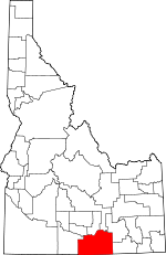
Cassia County, Idaho Basics:


Cassia County Idaho - Government Site

Population: 23,255
Area: 2565 square miles
County seat: Burley
Area code(s) in use: 208
Time zone: MST
High school graduate or higher: 77.8%
Bachelor's degree or higher: 16.1%
Median household income: $43,039
Persons in poverty: 16.1%
Home ownership rate: 69.4%
Mean travel time to work: 16.7 minutes


Adjacent counties:
Blaine  Box Elder (UT)  Elko (NV)  Jerome  Minidoka  Oneida  Power  Twin Falls  
Find in Idaho

Map of the Cassia County area


Our detail map of Cassia County shows the Cassia County, Idaho boundary lines and other interesting items.

Places in Cassia County, Idaho

  Airports     show all on map

Albion Municipal Airport, Burley Municipal Airport, Interstate Airport, Malta Airport, Oakley Municipal Airport, Rehn Ranch Landing Area, Savage Ranch Landing Area

  Areas     show all on map

Indian Grove

  Basins     show all on map

Burnt Basin, Elba Basin, Joes Basin, Magpie Basin, Steer Basin

  Bridges     show all on map

Jackson Bridge

  Buildings     show all on map

Ace Fire Protection District, Albion Fire Protection District, Albion Quick Response Unit, Almo Rock Quick Response Unit, Buckhorn Substation, Bureau of Land Management Burley Field Office, Burley Fire Department, Cassia County Sheriff's Office, Earncliff (historical), Malta Ambulance, North Cassia Rural Fire Department, Oakley Fire Department, Oakley Quick Response Unit, Raft River Fire Protection District Station 1, Raft River Fire Protection District Station 2, Raft River Fire Protection District Station 3

  Canals     show all on map

112 A Lateral, B 1 A Lateral, B 1 D Lateral, B 1 G Lateral, B 1 Lateral, B 1 Pipeline, B 2 Lateral, B 2 Pipeline, B Feeder, Danny Turner Pipeline, Declo Drain, F Waste Canal, G 11 A Lateral, G 11 Lateral, G 12 1/2 Lateral, G 12 1/2 Pipeline, G 14 Lateral, G 15 A Pipeline, G 15 B Lateral, G 15 B Pipeline, G 15 D Lateral, G 15 Lateral, G 15 Overland Pipeline, G 15 Pipeline, G 152 Lateral, G 16 B Lateral, G 16 Lateral, G 17 Lateral, G 18 A Lateral, G 18 D Lateral, G 18 Lateral, G 19 B Lateral, G 19 D Lateral, G 19 Lateral, G 2 Lateral, G 20 C Lateral, G 20 Drain, G 20 Lateral, G 7 A Lateral, G 8 Lateral, G 9 Lateral, G Waste, H 1 Lateral, H 1 Lateral, H 10 Lateral, H 12 D Lateral, H 12 J Lateral, H 12 K Lateral, H 12 Lateral, H 12 N Lateral, H 14 H Lateral, H 14 Lateral, H 15 A Lateral, H 15 A Pipeline, H 15 B Lateral, H 15 C Lateral, H 15 D Lateral, H 15 Lateral, H 16 A Lateral, H 16 C Lateral, H 16 E Lateral, H 16 F Lateral, H 16 H Lateral, H 16 J Lateral, H 16 K Lateral, H 16 Lateral, H 17 A Lateral, H 17 B Lateral, H 17 C Lateral, H 17 E Lateral, H 17 E Pipeline, H 17 G Lateral, H 17 H Lateral, H 17 H Lateral, H 17 Lateral, H 17 M Lateral, H 17 Rail Road Pipeline, H 17 Spill Pipeline, H 17 Spill Pipeline, H 18 1/2 Lateral, H 19 H Lateral, H 19 Lateral, H 2 A Lateral, H 2 B Lateral, H 2 C Lateral, H 2 D Lateral, H 2 Lateral, H 20 Lateral, H 22 A Lateral, H 22 B Lateral, H 22 B Pipeline, H 22 Lateral, H 23 Lateral, H 24 Pipeline, H 25 Pipeline, H 26 H Lateral, H 27 Lateral, H 29 Lateral, H 3 Lateral, H 30 Lateral, H 4 A Lateral, H 4 Lateral, H 6 Lateral, H 7 A Lateral, H 7 Lateral, H 8 1/2 Pipeline, H 8 A Lateral, H 8 Pipeline, H 9 Lateral, H Waste, J 1 Lateral, J 10 Lateral, J 11 Lateral, J 12 A Lateral, J 12 B Lateral, J 12 Lateral, J 12 Pipeline, J 13 Lateral, J 14 Lateral, J 15 Pipeline, J 16 Lateral, J 17 Pipeline, J 19 A Lateral, J 19 C Lateral, J 19 Lateral, J 19.1 Lateral, J 19.3 Lateral, J 2 A Lateral, J 2 B Lateral, J 2 Lateral, J 20 Lateral, J 21 A Lateral, J 21 B Lateral, J 21 Lateral, J 22 Lateral, J 23 A Lateral, J 23 C Lateral, J 23 D Lateral, J 23 D Pipeline, J 23 E Lateral, J 23 E Pipeline, J 23 F Lateral, J 23 F Lateral, J 23 Lateral, J 24 C Lateral, J 24 Lateral, J 24 Pipeline, J 25 A Lateral, J 25 Lateral, J 26 A Lateral, J 26 B Lateral, J 26 Lateral, J 26 Pipeline, J 27 1/2 Lateral, J 27 C Lateral, J 27 D Lateral, J 27 F Lateral, J 27 F Pipeline, J 27 F Waste, J 27 F Waste Pipeline, J 27 H Lateral, J 27 I Lateral, J 27 I Pipeline, J 27 J Lateral, J 27 Lateral, J 27 M Lateral, J 27 N Lateral, J 27 O Lateral, J 27 Pipeline, J 27 Q Lateral, J 27 R Lateral, J 28 1/2 Lateral, J 28 Pipeline, J 29 1/2 Lateral, J 29 A Lateral, J 29 Lateral, J 32 B Lateral, J 32 D Lateral, J 32 E Lateral, J 32 G Lateral, J 32 H Lateral, J 32 I Lateral, J 32 Lateral, J 33 A Lateral, J 34 Lateral, J 35 Lateral, J 36 Drain, J 36 Lateral, J 36 Pipeline, J 37 Pipeline, J 38 Lateral, J 39 B Lateral, J 39 Lateral, J 40 Lateral, J 6 Lateral, J 7 Lateral, J 8 Lateral, J 9 Lateral, J Waste, Lunch Creek Drain, Main South Side Canal, Morgan Drain, Priest Drain Ditch, Rassmussen Drain, Searle Drain, Snipe Drain, Spring Creek Drain, Summit Creek Ditch, Swig Pipeline, West Canal

  Cemeteries     show all on map

Basin Cemetery, Bower Cemetery, Declo Cemetery, Elba Cemetery, Jackson Cemetery, Malta Cemetery, Marion Cemetery, Olson Cemetery, Pella Ward Cemetery, Pleasant Hill Cemetery, Pleasant View Cemetery, Standrod Cemetery, Sunny Cedar Rest Cemetery, View Cemetery

  Churches     show all on map

Unity Church

  Dams     show all on map

Dewey Dam, Lake Cleveland Dam, Minidoka Dam, Oakley Dam, Sublett Dam

  Falls     show all on map

Phantom Falls

  Flats     show all on map

Bear Flat, Buckbrush Flats, Clyde Flat, Connor Flat, Durfee Meadow, Fuller Pasture

  Gaps     show all on map

Basin-Elba Pass, Beaverdam Pass, Daves Pass, Deerhorn Pass, Granite Pass, Lyman Pass, Pinnacle Pass, Stines Pass, The Narrows, Trout Creek Pass

  Hospitals     show all on map

Cassia Regional Medical Center

  Islands     show all on map

Goat Island, Hog Island, Parees Island

  Lakes     show all on map

Independence Lakes, J 36 Pond, J Waste Pond, Pot Holes

  Locales     show all on map

Big Bluff Picnic Ground (historical), Birch Glen Picnic Ground, Bostetter Campground, Bostetter Forest Service Station, Brackenbury Campground, Broken Circle Ranch, Buckhorn Ranch, Churchill, Churchill, Emery Pass Picnic Area, Emery Ranch, Father and Sons Campground, Fenstermaker Ranch, Frish Ranch, Gunnell Guard Station, Harrington Fork Picnic Area, Island, Jay Creek Corral, Jensen Ranch, Juniper Spring Campground (historical), Lake Fork Recreation Site, Lazy F C Ranch, Marion, Melcher Mine, Mikes Cabin, Moulton, Myers Mine, Parsons, Pella Siding, Pomerelle Ski Area, Porcupine Spring Picnic Area, Pumping Station 10, Rehn Ranch, Schipper Campground, Six-Mile Ranch, Starrhs Ferry, Steer Basin Campground, Sublett Recreation Site, Sublett Reservoir Access Area, Thompson Flat Campground, Three Hundred Thirty Spring Picnic Ground (historical), Twin Lakes Picnic Area, Wards Corral, Warm Creek Ranch, Warr

  Mines     show all on map

Hazel Pine Mine, Ruth Mine, Silver Hills Mine, Tallman Mine, Worthington Mine

  Parks     show all on map

Almo Park, Castle Rocks State Park, City of Rocks National Reserve, East Park, Elba Park, Freedom Park, Minidoka National Wildlife Refuge, West Park

  Pillars     show all on map

Bath Rock, Bread Loaf, Bread Loaves, Camel Rock, Camel Rock, Camp Rock, Castle Rock, City of Rocks, Elephant Rock, Farm Rock, Finger Rock, Granite Peak, Lone Rock, Mahogany Mountain, Parking Lot Rock, Pinnacle, Register Rock, Steinfells Dome, Train Rock, Treasure Rock, Turtle Rock, Twin Sisters

  Populated Places     show all on map

Albion, Almo, Basin, Beetville, Bridge, Burley, Conant, Connor, Cotterel, Declo, Elba, Garrard Ranch, Hazel (historical), Heglar, Hobson, Idahome, Iversons, Jackson, Kelso, Kenyon, Keogh, Malta, Marion, Naf, North Kenyon, Oakley, Pella, Raft River, Ruby, Springdale, Strevell, Sublett, Tipton (historical), Trout, Unity, View

  Post Offices     show all on map

Gunnell Post Office, Gunnell Post Office (historical)

  Ranges     show all on map

Albion Mountains, Black Pine Mountains, Castle Rocks, Cedar Hills, Cotterel Mountains, East Hills, Jim Sage Mountains, Middle Mountain

  Reserves     show all on map

Baker Wildlife Habitat Area North, Buckhorn Wildlife Habitat Area, Burley Wildlife Habitat Area Southwest, Butte Wildlife Habitat Area North, Butte Wildlife Habitat Area South, Cycle Wildlife Habitat Area, Dry Meadows Wildlife Habitat Area, Gifford Spring Wildlife Habitat Area, Golden Valley Wildlife Habitat Areas, Horse Butte Wildlife Habitat Area, Idahome Waterfowl Wildlife Habitat Areas, Idahome Wildlife Habitat Area, Jackson Lab Wildlife Habitat Area, Malta Wildlife Habitat Area North, Malta Wildlife Habitat Area South, Marion Number One Wildlife Habitat Area East, Marion Number One Wildlife Habitat Area South, Marion Number Two Wildlife Habitat Area East, Marion Number Two Wildlife Habitat Area South, Milner Butte Wildlife Habitat Areas, Milner Recreation Area, Minidoka Forest State Bird Sanctuary, North Rock Wildlife Habitat Area, Oakley Wildlife Habitat Area East, Piemeisel Wildlife Habitat Area, Power Line Wildlife Habitat Area, Rock Wildlife Habitat Area, Van Tassel Wildlife Habitat Area North, Van Tassel Wildlife Habitat Area South, Webb Brothers Wildlife Habitat Area, Yale Wildlife Habitat Area East, Yale Wildlife Habitat Area West

  Reservoirs     show all on map

Deadeye Reservoir, Fuller Reservoir, Keith Reservoir, Lake Cleveland, Lake Walcott, Lincoln Reservoir, Lower Goose Creek Reservoir, Sixmile Reservoir, Sublett Reservoir

  Ridges     show all on map

Connor Ridge, Cotton Ridge, Cottonwood Ridge, Hudson Ridge, Rams Horn Ridge

  Schools     show all on map

Albion Elementary School, Almo Elementary School, Burley Junior High School, Burley Senior High School, Declo Elementary School, Declo Junior-Senior High School, Dworshak Elementary School, Miller School, Mountain View Intermediate School, Oakley Elementary School, Oakley Junior-Senior High School, Overland Elementary School, Raft River Elementary-Junior High School, Raft River High School, Southwest Elementary School, Springdale Kindergarten School

  Springs     show all on map

330 Spring, Antelope Spring, Antelope Spring, Arrowhead Spring, Aspen Spring, Badger Gulch Spring, Badger Mountain Spring, Barnes Spring, Basin Patch Spring, Bear Gulch Spring, Beaverdam Pass Spring, Bed Spring, Bedke Spring, Bennett Spring, Big Pipe Spring, Birch Spring, Black Pine Spring, Black Sand Spring, Boosinger Spring, Bostetter Pasture Spring, Bostetter Spring, Bowers Spring, Bridger Spring, Briggs Spring, Bruce Young Spring, Buck Spring, Buckbrush Spring, Buckhorn Spring, Bull Spring, Burn Spring, Butler Spring, Buttars Spring, Cabin Spring, Cabin Spring Number Two, Calder Spring, Carlson Spring, Cedar Birch Spring, Cedar Hollow Spring, Chalk Spring, Chicken Spring, Chokecherry Spring, Clint Palmer Spring, Coal Banks Spring, Coal Pit Spring, Cold Spring, Cold Spring, Cold Spring, Cold Spring, Coldwater Spring, Corral Spring, Cotton Spring, Cottonwood Spring, Counting Chute Spring, Cow Gulch Spring, Cow Spring, Cow-S Spring, Cowboy Spring, Coyote Spring, Coyote Spring, Cranny Spring, Crystal Spring, Dairy Spring, Daves Pass Spring, Deadeye Spring, Dry Flat Spring, Dry Fork Spring, Dry Fork Spring, Dry Fork Swanty Creek Spring, Dry Gulch Spring, Dummer Spring, East Line Spring, Elk Basin Spring, Elk Butte Spring, Emery Canyon Spring, Ether Park Spring, F S Spring, Fisher Spring, Flatiron Spring, Formation Springs, Fourmile Spring, Frahm Spring, Franks Hollow Spring, Franks Spring, Gravel Spring, Grouse Spring, Heath Spring, Hidden Rock Spring, Hole in the Wall Spring, Horseshoe Spring, Hot Spring, Hot Springs, Howell Creek Spring, Hudson Ridge Spring, Humphrey Spring, Hutchey Spring, Indian Camp Spring, Indian Spring, Indian Spring, Jarvis Spring, Jay Creek Spring, Jeffs Spring, Jim Sage Spring, Jones Spring, Kane Spring, Keg Hollow Spring, Kidd Spring, Lake Fork Spring, Land Ranch Spring, Land Spring, Layton Spring, Ledge Rock Spring, Little Cottonwood Spring, Little Fork Spring, Little Piney Spring, Little Squaw Creek Spring, Little Willow Spring, Lloyd Spring, Logger Spring, Lone Cedar Spring, Lone Pine Spring, Lost Hat Spring, Lost Tunnel Spring, Lower Heglar Spring, Mabey Spring, Mabey Spring Number 2, Magpie Spring, Martindale Spring, McClenden Spring, Meadow Spring, Middle Ridge Spring, Mill Canyon Spring, Mine Dump Spring, Moonshine Spring, Mortenson Spring, Mud Spring, Mud Spring, Mud Spring, Mud Spring, N W Spring, Nibbs Spring, North Water Spring, Oliver Spring, Orangeburg Spring, Owens Corral Spring, Palmer Spring, Parke Spring, Picketts Lower Trough Spring, Picketts Upper Trough Spring, Pike Mountain Spring, Pine Grove Spring, Pine Grove Spring, Pleasant Spring, Pocket Spring, Point Spring, Point Spring, Pollard Spring, Porcupine Spring, Porcupine Spring, Potter Spring, Poulton Spring, Quaking Aspen Spring, Rattlesnake Spring, Red Bluff Spring, Red Rock Spring, Reed Spring, Rice Canyon Spring, Rice Spring, Rice Spring, Right Hand Fork Spring, Rim Rock Spring, Rock Spring, Rock Spring, Rodeo Spring, Round Mountain Spring, Sage Hen Spring, Salt Lick Spring, Sand Spring, Sanford Spring, Savage Hollow Spring, Section 9 Spring, Severe Spring, Sheep Spring, Sibley Spring, Silver Hills Spring, Sixmile Spring, Slide Spring, South Cottonwood Spring, South Fisher Spring, South Fork Fall Creek Spring, South Fork Fall Creek Spring, South Fork Kelsaw Spring, South Heglar Spring, Sparks Spring, Swanty Spring, Swede Spring, Taylor Spring, Telephone Spring, Tent Spring, Terrells Spring, Thoroughbred Pond Spring, Thoroughbred Spring Number One, Thoroughbred Spring Number Two, Trail Canyon Spring, Triple Spring, Trout Creek Pass Spring, Trout Spring, Tub Spring, Tub Spring, Twin Springs, Upper Coal Pit Spring, Upper Fall Creek Spring, Upper Heglar Spring, Upper Lake Fork Spring, Upper Squaw Creek Spring, W P A Spring, Warm Spring, Water Canyon Spring, West Dry Canyon Spring, Whiskey Spring, Whitey Davis Spring, Wilson Spring, Womack Canyon Spring, Worm Corral Spring, Worthington Spring, Young Spring

  Streams     show all on map

A H Creek, Almo Creek, Amos Creek, Aspen Creek, Aspen Creek, Badger Creek, Barnes Creek, Bath Rock Creek, Bear Flat Creek, Beatty Creek, Beaverdam Creek, Big Rocky Creek, Billys Hole Creek, Birch Creek, Birch Creek, Birch Creek, Black Creek, Blacksmith Creek, Blind Creek, Blue Hill Creek, Buck Corral Creek, Buck Creek, Buckhorn Creek, Cabin Spring Creek, Calder Creek, Carlson Creek, Cassia Creek, Center Creek, Center Creek, Cherry Creek, Chokecherry Creek, Circle Creek, Clear Creek, Clyde Creek, Coal Banks Creek, Coal Pit Creek, Coe Creek, Cold Creek, Cold Spring Creek, Cold Spring Creek, Connor Creek, Cotton Creek, Cottonwood Creek, Cottonwood Creek, Cottonwood Creek, Cow Creek, Coyote Creek, Coyote Creek, Coyote Creek, Cross Creek, Dayley Creek, Deer Creek, Dry Creek, Dry Fork, Dry Fork, Dry Fork, Dry Fork, Dry Fork, Dry Fork Little Cottonwood Creek, Duck Creek, East Fork Dry Creek, East Fork Thoroughbred Creek, Ecklund Creek, Edwards Creek, Elison Hole Creek, Elk Basin Creek, Emery Creek, F S Spring Creek, Fall Creek, Fall Creek, First Fork Rock Creek, Fish Creek, Flat Canyon Creek, Flatiron Creek, Fourth Fork Rock Creek, George Creek, Goose Creek, Graham Creek, Granite Creek, Grape Creek, Gray Creek, Green Creek, Green Pine Creek, Harrington Fork, Heath Creek, Holt Creek, Howell Creek, Humphrey Creek, Indian Camp Spring Creek, Indian Fork, Jay Creek, Johnson Creek, Johnson Creek, Jones Creek, Lake Creek, Lake Fork, Land Creek, Land Creek, Left Hand Fork Beaverdam Creek, Little Cottonwood Creek, Little Cove Creek, Little Fork Third Fork Rock Creek, Little Goose Creek, Little Piney Creek, Little Squaw Creek, Little Willow Creek, Lone Cedar Creek, Lone Rock Creek, Lunch Creek, Marsh Creek, Martindale Fork, Meadow Creek, Medley Creek, Middle Fork Dry Creek, Middle Fork Third Fork Rock Creek, Mill Creek, Mountain Meadow Creek, Mountain View Creek, N E Creek, Narrows Creek, New Canyon Creek, Nibbs Creek, North Carson Creek, North Creek, North Fork Narrows Creek, Onemile Creek, Owens Corral Creek, Palmer Creek, Parks Creek, Pickett Spring Creek, Pine Creek, Pole Creek, Pole Creek, Porter Creek, Quaking Asp Creek, Raft River, Rattlesnake Creek, Rice Creek, Rice Creek, Right Hand Fork Beaverdam Creek, Robinson Creek, Rodeo Creek, Rose Creek, Round Mountain Creek, Sawmill Creek, Sawmill Creek, Second Fork Rock Creek, Shirley Creek, Sibley Creek, Slide Creek, Smith Creek, South Cottonwood Creek, South Creek, South Creek, South Fork Little Piney Creek, South Fork Narrows Creek, Spring Creek, Spring Creek, Spring Creek, Squaw Creek, Stines Creek, Stinson Creek, Sublett Creek, Summit Creek, Summit Creek, Summit Creek, Summit Station Creek, Swanty Creek, Taters Creek, Terrells Corral Creek, Third Fork Rock Creek, Thoroughbred Creek, Trail Creek, Trail Creek, Trapper Creek, Van Camp Creek, Walters Creek, Warm Creek, Waterfall Creek, West Fork Dry Creek, West Fork Thoroughbred Creek, White Creek, White Stump Creek, Wildcat Creek, Willow Creek, Willow Creek, Winecup Creek, Wooden Shoe Creek

  Summits     show all on map

Antelope Hill, Badger Mountain, Badger Peak, Black Pine Cone, Black Pine Peak, Blue Hill, Burley Butte, Cache Peak, Cedar Creek Peak, Cedar Knoll, Coal Pit Butte, Dads Hump, Eagle Point, Elk Butte, Flatiron Mountain, Freds Mound, Fuller Peak, Graham Peak, Harrington Peak, Horse Butte, Ibex Peak, Independence Mountain, Joes Mountain, Lbex Peak, Mahogany Butte, Milner Butte, Monument Peak, Mount Harrison, Mount Independence, North Chapin Mountain, Pike Mountain, Pine Knob, Pine Tit, Red Rock Mountain, Round Mountain, Sheep Mountain, Smoky Mountain, South Chapin Mountain, South Tit, Swanty Peak, The Knolls, Thunder Mountain, Trapper Peak, Trout Creek Mountain, War Eagle Peak, Willow Creek Peak

  Towers     show all on map

KBAR-AM (Burley), KCIR-FM (Twin Falls), KNAQ-FM (Rupert), KZDX-FM (Burley)

  Trails     show all on map

California Trail, California Trail - Salt Lake Alternate, Rangers Trail

  Valleys     show all on map

Antelope Valley, Badger Gulch, Bear Gulch, Bear Hollow, Bedke Canyon, Big Canyon, Big Canyon, Big Cedar Canyon, Big Cedar Canyon, Big Cove, Big Hollow, Big Rock Canyon, Black Pine Canyon, Black Sand Hollow, Boulder Canyon, Brim Canyon, Broad Hollow, Brush Canyon, Buckhorn Canyon, Burnt Canyon, Carlson Canyon, Cave Canyon, Cave Gulch, Chokecherry Canyon, Cliff Hollow, Cold Spring Canyon, Cold Spring Canyon, Cooney Hollow, Day Canyon, Deer Hollow, Devine Canyon, Dry Canyon, Dry Gulch, East Dry Canyon, Echo Hollow, Eightmile Canyon, Elbow Canyon, Emery Canyon, Emigrant Canyon, First Hollow, Fisher Canyon, Formation Canyon, Franks Canyon, Franks Hollow, Grassy Hollow, Gray Canyon, Green Canyon, Guinn Canyon, Harroun Canyon, Heath Canyon, Heath Canyon, Heglar Canyon, Horse Hollow, Howell Canyon, Hutchey Canyon, Ibex Hollow, Jim Sage Canyon, Johnnys Canyon, Jones Canyon, Jones Hollow, Kane Canyon, Keg Hollow Canyon, Kelsaw Canyon, Kemp Hollow, Line Canyon, Little Cedar Canyon, Little Cedar Canyon, Little Cove, Little Cove, Little Eightmile Canyon, Lower Mill Canyon, Mackey Canyon, Mackey Wash, Mill Canyon, Mill Fork, Mill Fork, Mineral Gulch, Moberg Canyon, Monument Canyon, Mortenson Canyon, Mud Spring Canyon, Myers Canyon, N E Canyon, Narrow Canyon, North Fork Sandrock Canyon, North Heglar Canyon, Palmer Canyon, Pickett Hollow, Pine Canyon, Poison Gulch, Poison Hollow, Pole Canyon, Pole Canyon, Quartz Gulch, Raft River Valley, Rice Canyon, Rice Hollow, Robber Gulch, Rocky Canyon, Rocky Hollow, Ruby Gulch, Sandrock Canyon, Savage Hollow, Sheep Canyon, Sixmile Canyon, Slide Canyon, South Heglar Canyon, Spring Canyon, Spring Canyon, Spring Canyon, Strevell Canyon, Stump Hollow, Sweetzer Canyon, Telephone Canyon, Trail Canyon, Upper Raft River Valley, Violets Hollow, Von Canyon, Wahlstrom Hollow, Walker Hollow, Water Canyon, Water Canyon, West Dry Canyon, White Pine Canyon, Wilson Gulch, Womack Canyon, Worm Corral Hollow

  Wells     show all on map

Hogan Well, Kenyon Substation Well,

Cassia County, Idaho Population By Race (2012 estimate)

RacePopulation
WhiteCassia County White population 22,25522,255  
MixedCassia County Mixed population 349348
American IndianCassia County American Indian population 326325
AsianCassia County Asian population 163162
BlackCassia County Black population 140139
Hawaiian & Pacific IslanderCassia County Hawaiian & Pacific Islander population 2323

Additional population tables :
State population table
Idaho population by county