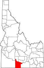
Twin Falls County, Idaho Basics:


Twin Falls County Idaho - Government Site

Population: 78,515
Area: 1921 square miles
County seat: Twin Falls
Area code(s) in use: 208
Time zone: MST
High school graduate or higher: 83.6%
Bachelor's degree or higher: 16.0%
Median household income: $42,639
Persons in poverty: 15.4%
Home ownership rate: 66.9%
Mean travel time to work: 16.6 minutes


Adjacent counties:
Cassia  Elko (NV)  Elmore  Gooding  Jerome  Owyhee  
Find in Idaho

Map of the Twin Falls County area


Our detail map of Twin Falls County shows the Twin Falls County, Idaho boundary lines and other interesting items.

Places in Twin Falls County, Idaho

  Airports     show all on map

Buhl Municipal Airport, Magic Valley Regional Medical Center Heliport, Twin Falls Airport

  Basins     show all on map

Antelope Pocket, Cottonwood Basin, Donahue Basin, Elk Basin, Horse Basin, McMullen Basin, Melon Valley, Pine Basin, Pot Hole Basin, Shoshone Basin

  Bays     show all on map

Big Bay, Walts Bay

  Benches     show all on map

Browns Bench

  Bridges     show all on map

Hansen Bridge, Owsley Bridge, Perrine Memorial Bridge

  Buildings     show all on map

Ambulance Service of Magic Valley Regional Medical Center Station 2, Ambulance Service of Magic Valley Regional Medical Center Station 3, Artesian Substation, Blue Lakes Country Club, Blue Lakes Mall, Buhl City Hall, Buhl City Police Department, Buhl Fire Department Station 1, Buhl Fire Department Station 2, Buhl Library, Bureau of Land Management Jarbidge Field Office, Bureau of Land Management Twin Falls District, Castleford City Hall, Castleford Fire District, Filer City Police Department, Filer Fire Department, Hansen City Hall, Hansen Police Department, Herrett Museum, Kimberly City Hall, Kimberly City Police Department, Magic Valley Mall, Mountain Home Care Center, National Guard Center, Rock Creek Fire Department Station 1, Rock Creek Fire Department Station 3, Salmon Tract Rural Fire District Station 1, Salmon Tract Rural Fire District Station 2, Twin Falls City Hall, Twin Falls County Courthouse, Twin Falls County Sheriff's Office, Twin Falls Fire Department Station 1, Twin Falls Fire Department Station 2, Twin Falls Fire Department Station 3, Twin Falls Fire Department Station 4, Twin Falls Police Department

  Canals     show all on map

A Lateral, Cassia Canal, Cedar Mesa Canal, Clark Lateral, Fossil Gulch Canal, High Line Canal, High Line North Canal, Lateral 213, Lateral No 13, Lateral Number 15, Lateral Number 17, Lateral Number 21, Low Line Canal, Magic Water Canal, Magic Water Canal, Main Canal, Milner Main Canal, Tuana Canal, Twin Falls Main Canal, Worley Ditch

  Capes     show all on map

Luds Point

  Cemeteries     show all on map

Buhl Cemetery, Independent Order of Odd Fellows Cemetery, Rock Creek Cemeteries, Sunset Memorial Park Cemetery, Twin Falls Cemetery

  Cliffs     show all on map

Eagle Bluff, Tool Point

  Crossings     show all on map

Balanced Rock Crossing, Balanced Rock Crossing, Cedar Creek Crossing, Tuanna Crossing

  Dams     show all on map

Cedar Creek Dam, Cedar Creek Holding Dam, Deep Creek Number One Dam, Deep Creek Number Two Dam, Easterday Dam, Heil Dam, McMullen Creek Dam, Milner Dam, Munsee Dam, Murtaugh Lake Dam, Salmon Falls Creek Dam, Salmon Falls Dam, Williams Dam

  Falls     show all on map

Auger Falls, Perrine Coulee Falls, Pillar Falls, Pillar Falls, Ross Falls, Salmon Falls, Shoshone Falls, Upper Salmon Falls

  Flats     show all on map

Beaver Meadows, Goose Pasture, John Boyd Flat, Mud Flat, Mud Lake, Sagehen Flats, Sucker Flat, Thoroughbred Flat

  Hospitals     show all on map

Canyon View Hospital, Magic Valley Memorial Hospital, Magic Valley Speech and Hearing Clinic, Saint Luke's Magic Valley Regional Medical Center

  Islands     show all on map

Dolman Island

  Lakes     show all on map

Bluegill Lake, Cedar Draw Lake, Dierkes Lake, Dry Pond, Echo Lake, Johns Pond, Mary Alice Lake, Mary Alice Lake, Merles Pond, Twin Lakes

  Locales     show all on map

Antelope Spring Ranch, Avelar's Dairy, Banbury Natatorium (historical), Bear Gulch Campground, Big Creek Ranch, Blue Lakes Shopping Center, Bokma Dairy, Canyonview Farm, Cedar Draw School, Champlin Farms, China Creek Ranch, Clark Ranch, Conover Ranch, Curry Station, Deadline Corral, Deep Creek Meadows Ranch, Devil Creek Ranch, Devries Dairy, Diamond H Dairy, Duck Springs Ranch, Fairview Dairy, Federation Lookout, Federation Lookout, Frontier Dairy, Guerry Corral, Guy Kinyon Cabin, Hansen Substation (historical), Heidemann Dairy, Heritage Farms, House Creek Ranch, Idavada (historical), Kirkman Campground, Knull Community Center, Kum Ba Yah Camp, Lake Substation, Lincoln Corral, Lone Pine, Lower Penstemon Campground, Lucerne Grange, Lynnwood Shopping Center, Magic Hot Springs, Magic Milk Dairy, Magic Mountain Ski Area, Magic Valley Mall, McMillan Siding, McMullen Cow Camp, Meteor (historical), Mid Valley Dairy, Milner Station, Murtaugh Lake Access Area, No View Dairy, Northview Grange, Owsley Bridge Access Area, Pax Dairy Farm, Pettit Campground, Point Ranch, Redcap Corner, Rock Creek Guard Station, Rock Ridge Dairy, Rutherford Cabin, Schilder Dairy, Shoshone Cabin, Shoshone Forest Service Station, Silva Dairy, Springtown, Steel Place, Stricker Cabin, Sudik Dairy, Sully (historical), Superior School, Tawakani Camp, Thunder Bluff Speedway, Triple J Dairy, Twin Falls County Fairgrounds, United States Department of Agriculture and University of Idaho Research Center, United States Department of Agriculture and University of Idaho Research Center, Upper Penstemon Campground, Vierstra Dairy

  Parks     show all on map

Balanced Rock County Park, Balanced Rock State Park, Barry Park, Cascade Park, Cascade Park, Dierkes Lake Park, Eastman Park, Filer Community Park, Frontier Park, Hagerman Fossil Beds National Monument, Harmon Park, Harrison Park, J-C Park, Murtaugh Lake County Park, Rock Creek Park, Shoshone Falls Park, Sunrise Park

  Pillars     show all on map

Balanced Rock

  Populated Places     show all on map

Abbey (historical), Amsterdam, Anderson Place, Artesian City, Austin (historical), Berger, Bergstrom Place, Bickel (historical), Bills, Buhl, Castleford, Cedar, Clover, Curry, Deep Creek, Duncan Place, Fairview, Filer, Godwin, Greys Landing, Hand Place, Hansen, Harrell Place, Hoelzle Place, Hollister, Indian Jim Place, Kimberly, Knull, May Place, McMillan, Milner, Murtaugh, Peavey, Player Place, Rock Creek, Rock House Place, Rogerson, Roseworth, Striker, Threemile Crossing, Twin Falls, Vosburg Place

  Post Offices     show all on map

Buhl Post Office, Castleford Post Office, Filer Post Office, Twin Falls Post Office (historical)

  Rapidss     show all on map

Caldron Linn, Dolman Rapids

  Reservoirs     show all on map

Berger Reservoir, Bliss Reservoir, Cedar Creek Reservoir, Cedar Mesa Reservoir, Curtis Reservoir, Deep Creek Reservoir, Dry Cottonwood Reservoir, Dry Fork Reservoir, Lower Deep Creek Reservoir, Milner Lake, Murtaugh Lake, Salmon Falls Creek Reservoir, Upper Burnt Creek Reservoir, Williams Reservoir, Worley Reservoir

  Ridges     show all on map

Buckskin Ridge, Deadline Ridge, North Cottonwood Ridge

  Schools     show all on map

Agape Christian School, Bickel Elementary School, Buhl High School, Buhl Junior High School, Buhl Middle School, Buhl School (historical), Buhl Senior High School, Castleford Elementary-Middle School, Castleford High School, Castleford Senior High School, Clover Trinity Lutheran School, College of Southern Idaho, College of Southern Idaho, Elmwood Elementary School, Filer Elementary School, Filer High School, Filer Junior High School, Filer Middle School, Filer Senior High School, Hansen Elementary School, Hansen High School, Hansen Junior-Senior High School, Harrison Elementary School, Hollister Elementary School, I B Perrine Elementary School, Immanuel Lutheran School, Kimberly Elementary School, Kimberly Elementary School, Kimberly High School, Kimberly High School, Kimberly Junior High School, Kimberly Middle School, Lincoln Elementary School, Lincoln School, Lucerne School, Magic Valley Alternative High School, Magic Valley Seventh-Day Adventist School, Maroa School (historical), Memorial School (historical), Morningside Elementary School, Murtaugh Elementary School, Murtaugh High School, Murtaugh Middle School - High School, Perrine Elementary School, Pleasant Valley School, Poplar Hill School, Popplewell Elementary School, Popplewell School, Robert Stuart Junior High School, Saint Edwards School, Saint Johns School, Sawtooth Elementary School, Sawtooth School, South Central Head Start, Syringa School, Twin Falls Christian Academy, Twin Falls County Museum, Twin Falls High School, Twin Falls Senior High School, Union School (historical), Vera C O'Leary Junior High School, Vera O'Leary Junior High School, Washington School, Washington School (historical)

  Slopes     show all on map

Crystal Springs Grade

  Springs     show all on map

Antelope Spring, Arkansas Spring, Ashbury Spring, Bald Hill Spring Number 1, Bald Hill Spring Number 2, Barbour Spring, Basin Spring, Basque Spring, Beatty Spring, Beer Mug Spring, Big Spring, Black Canyon Spring, Blue Mud Spring, Bone Spring, Box Canyon Spring, Box Spring, Browns Spring, Buck Trough Spring, Bud Spring, Bull Spring, Burnt Cabin Spring, Buzzard Spring, Camp Spring, Chad Spring, Charlie Brackett Spring, Cherry Spring, Clark Spring, Cliff Spring, Cottonwood Ridge Spring, Cow Spring, Coyote Spring, Coyote Spring, Crockett Spring, Cub Spring, Dan Spring, Deer Spring, Diamond Flat Spring, Dove Spring, Duck Spring, Eagle Spring, Electric Spring, Elk Corral Spring, Elk Spring, Emerson Spring, Fawn Spring, Fourth of July Spring, Goat Springs, Grassy Spring, Grouse Creek Spring, Hale Spring, Halfway Spring, Hinton Spring, Hoops Spring, Hopper Gulch Spring, Horse Basin Spring, Horse Spring, Horse Springs, Hot Sulphur Springs, Indian Spring, Japanese Spring, Jim Lee Spring, Joes Spring, John Spring, Junction Spring, Lamb Spring, Lava Spring, Lilly Spring, Lime Spring, Line Spring, Lone Pine Spring, Lost Spring, Lunch Spring, Mauldin Springs, McConnell Spring, Meadow Springs, Moonshine Spring, Mountain View Spring, Mud Spring, Muddy Spring, Mule Creek Springs, Nat-Soo-Pah Warm Spring, Nelson Spring, North Willow Springs, Northeast Spring, Orin Spring, Parker Spring, Pedro Spring, Pine Basin Spring, Pole Camp Spring, Pond Spring, Port Spring, Pot Hole Spring Number 2, Rabbit Spring, Reynolds Springs, Rice Creek Spring, Rickenbacker Spring, Rimrock Spring, Rings Springs, Rock Cabin Spring, Rogerson Spring, Sage Hen Springs, Sagehen Spring, Sanitary Spring, Section Spring, Sheep Spring, Shoshone Spring, Soldier Spring, South Willow Spring, Southeast Spring, Squaw Joe Spring, Stove Gulch Spring, Stratton Spring, Strawberry Spring, Sugarloaf Spring, Summit Spring, Tank Spring, Thoroughbred Spring, Threemile Spring, Threemile Spring, Timber Spring, Tuana Spring, Tunnel Hill Spring, U C Spring, Van Eaton Spring, Wagon Spring, Wagonwheel Spring, Whir Spring, Whittle Spring, Williams Spring, Williams Spring, Willis Spring, Willow Spring, Winecup Spring, Winter Spring, Wooden Shoe Spring, Yellow Jacket Spring

  Streams     show all on map

A Lateral, Barbour Creek, Big Cottonwood Creek, Big Creek, Bluff Creek, Browns Creek, Burnt Creek, Cedar Creek, China Creek, Clear Creek, Cottonwood Creek, Cottonwood Creek, Cottonwood Creek, Deep Creek, Deep Creek, Desert Creek, Devil Creek, Diamond Creek, Donahue Creek, Doodlelink Creek, Dry Cottonwood Creek, Dry Creek, Eagle Spring Creek, Electric Spring Creek, Fifth Fork Rock Creek, Goat Springs Creek, Green Creek, Hannahs Fork, Horse Creek, Horse Creek, Hot Creek, House Creek, Indian Mike Creek, Indian Spring Creek, Jack Creek, Jones Fork Creek, Langford Flat Creek, Little Creek, Little House Creek, McMullen Creek, Meadow Spring Creek, Middle Fork Hannahs Fork, Middle Fork Shoshone Creek, Milligan Creek, Mud Creek, North Cottonwood Creek, North Fork Deep Creek, North Fork Hannahs Fork, North Fork Shoshone Creek, North Willow Springs Creek, Perrine Coulee, Player Creek, Pole Camp Creek, Rice Creek, Rock Creek, Salmon Falls Creek, Secret Creek, Sheep Spring Creek, Soldier Creek, South Fork Deep Creek, South Fork Shoshone Creek, South Hannahs Fork, Taylor Creek, Toolbox Creek, Whiskey Slough, Willow Spring Creek

  Summits     show all on map

Bald Hill, Berger Butte, Black Mountain, Bobcat Butte, Bud Lewis Hill, Calhoun Butte, Castleford Butte, Cedar Butte, Cedar Hill, China Mountain, Devil Creek Butte, Emery Butte, Flatiron, Grand View Peak, Hansen Butte, Hub Butte, Little Tug, Mountain View Peak, Pigtail Butte, Player Butte, Salmon Butte, Secret Cabin Butte, Signal Butte, Steamboat, Stricker Butte, Sugarloaf, Sugarloaf, Sunset Butte, Sunset Butte, Timber Butte, Tuanna Butte, Twin Buttes, Wooden Shoe Butte

  Towers     show all on map

KAWZ-FM (Twin Falls), KEZJ Radio Tower (Twin Falls), KEZJ-AM (Twin Falls), KLIX Radio Tower (Twin Falls), KLIX-AM (Twin Falls), KLIX-AM (Twin Falls), KLIX-FM (Twin Falls), KTFI Radio Tower (Twin Falls), KTFI-AM (Twin Falls)

  Tunnels     show all on map

Clarr Tunnel, Orchalara Seepage Tunnel, Sigrisit Tunnel

  Valleys     show all on map

Antelope Canyon, Arnolds Gulch, Bear Gulch, Black Canyon, Blue Gulch, Browns Canyon, Cedar Draw, Cedar Draw, Cedar Draw, Cedar Draw, Corral Creek Canyon, Deadman Gulch, Deadman Gulch, Deadmans Gulch, Deer Canyon, Dry Gulch, Dry Gulch, Fossil Gulch, Hopper Gulch, Indian Jim Canyon, Jack Walker Draw, John Boyd Draw, Lucky Gulch, Malat Draw, McCongle Canyon, Middle Canyon, Monument Canyon, Nevada Gulch, Niles Gulch, North Canyon, Peters Gulch, Player Canyon, Pleasant Valley, Rocky Canyon, Rocky Canyon, Sinking Canyon, Squaw Joe Canyon, Taylor Canyon, Timber Canyon, Trail Gulch, Tuana Gulch, West Basin Draw, Worley Draw

  Wells     show all on map

Alvins Well, Berger Well,

Twin Falls County, Idaho Population By Race (2012 estimate)

RacePopulation
WhiteTwin Falls County White population 74,58974,589  
MixedTwin Falls County Mixed population 1,3351,334
American IndianTwin Falls County American Indian population 942942
BlackTwin Falls County Black population 471471
Hawaiian & Pacific IslanderTwin Falls County Hawaiian & Pacific Islander population 157157

Additional population tables :
State population table
Idaho population by county