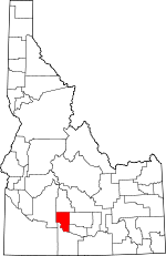
Gooding County, Idaho Basics:


Gooding County Idaho - Government Site

Population: 15,208
Area: 729 square miles
County seat: Gooding
Area code(s) in use: 208
Time zone: MST
High school graduate or higher: 76.3%
Bachelor's degree or higher: 12.4%
Median household income: $37,910
Persons in poverty: 20.6%
Home ownership rate: 70.8%
Mean travel time to work: 19.0 minutes


Adjacent counties:
Camas  Elmore  Jerome  Lincoln  Twin Falls  
Find in Idaho

Map of the Gooding County area


Our detail map of Gooding County shows the Gooding County, Idaho boundary lines and other interesting items.

Places in Gooding County, Idaho

  Airports     show all on map

Gooding Municipal Airport

  Areas     show all on map

Devils Wash Bowl

  Basins     show all on map

Devils Washbasin (historical)

  Bridges     show all on map

Gridley Bridge, Gridley Bridge

  Buildings     show all on map

Bliss Fire District, Bliss Quick Response, Gooding City Rural Fire Department, Gooding County Emergency Medical Services, Gooding County Sheriff's Office, Gooding Police Department, Hagerman City Hall, Hagerman Fire Protection District, Wendell Police Department, Wendell Rural Fire District / Wendell City Fire Department

  Canals     show all on map

1465 Lateral, Bell Ditch, Big Bend Ditch, Bostrum Canal, Brailsford Ditch, Buckeye Ditch, Carpenter Ditch, Clover Creek, Crosstie, Curren Ditch, Dog Creek, Dog Creek Drain, Gooding City Overflow, Hunt Ditch, J-11 Pipeline, Krawl, Krawl Waste, Lateral 10 South, Lateral 10 South A, Lateral 1300, Lateral 1310, Lateral 1429, Lateral 1465A, Lateral 1465A1, Lateral 1465A2, Lateral 1465A3, Lateral 1465B, Lateral 1566, Lateral 1590, Lateral 1590A, Lateral 1660, Lateral 1665, Lateral 1685, Lateral 3316, Lateral 3453, Lateral 916, Lateral 916D, Lateral B1, Lateral B1A, Lateral B1A1, Lateral B1B, Lateral B2, Lateral B3, Lateral B4, Lateral J-8, Lateral L-4, Lateral LA-4, Lateral LS, Lateral N-10, Lateral NB1, Lateral NB1A, Lateral NB2, Lateral S-10, Lateral S-12, Lateral S-19, Lateral S-2, Lateral S-20, Lateral S-22, Lateral S-23, Lateral S-25, Lateral S-27, Lateral S-29, Lateral S-31, Lateral S-33, Lateral S-39, Lateral S-8, Lateral W-14, Lateral W-15, Lateral W-18, Lateral W-19, Lateral W-20, Lateral W-26, Lateral W-28, Lateral W-3, Lateral W-33, Lateral W-34, Lateral W-35, Lateral W-36, Lateral W-37, Lateral W-40, Lateral W-45, Lateral W-46, Lateral W-47, Lateral W-53, Lateral W-54, Lateral W-56, Lateral W-57, Lateral W-58, Lateral W-7, Lateral W-9, Lateral X-1, Lateral X-10, Lateral X-11, Lateral X-14, Lateral X-15, Lateral X-18, Lateral X-19, Lateral X-24, Lateral X-29, Lateral X-3, Lateral X-30, Lateral X-31, Lateral X-32, Lateral X-33, Lateral X-4, Lateral X-5, Lateral X-7, Lateral Y-1, Lateral Y-4, Lateral Y-8, Lateral Z-4, Lateral Z-6, North Gooding Main Canal, Pipeline Ditch, Poorman Ditch, Randolf Ditch, Robertson Ditch, Sands Ditch, South Gooding Main Canal, South Gooding Siphon, Twin Falls North Main Canal, Union 2 Ditch, Union Ditch, Union Spillway, W Canal, Waste Ditch, X Canal, Y Canal, Z Canal

  Capes     show all on map

Bliss Point

  Cemeteries     show all on map

Elmwood Cemetery, Pioneer Cemetery, Pioneer Cemetery (historical)

  Churches     show all on map

Bliss Community Church

  Dams     show all on map

Bliss Dam, Bliss Dam, Bray Lake Dam, Clear Lake Dam, Dog Creek Dam, Lower Salmon Falls Dam, Pioneer Dam, Thorn Creek Dam, Upper Salmon Falls Dam

  Falls     show all on map

Devils Washboard Falls, Lower Salmon Falls

  Flats     show all on map

Connet Flat, Dead Horse Flat, Dempsey Meadows, Ferguson Flat

  Hospitals     show all on map

North Canyon Medical Center

  Islands     show all on map

Gridley Island, Millet Island

  Lakes     show all on map

Bray Lake, Lye Lake

  Locales     show all on map

Appleton Siding, Bell Rapids Access Area, Bray Lake Ranch, Buckeye Ranch, Cedar Draw School (historical), Clear Lake Country Club, Crist Cabin, Dog Creek Reservoir Public Fishing Area, Gooding County Fairgrounds, Hagerman National Fish Hatchery, Hagerman State Fish Hatchery, Hole-In-The-Wall Cabin, Idaho Power Company Steelhead Trout Hatchery, Niagara Springs Hatchery, Randolf Pipe, Snake River Fish Hatchery, Ticeska, Ticeska Station, West Point

  Mines     show all on map

Chalk Mine

  Parks     show all on map

Billingsley Creek Wildlife Management Area, Hagerman City Park, Hagerman Wildlife Management Area, Malad Gorge State Park, Malad Gorge State Park, McGinnis Park, Niagara Springs Wildlife Management Area

  Pillars     show all on map

City of Rocks, Little City of Rocks

  Populated Places     show all on map

Appleton, Bliss, Fuller, Gooding, Hagerman, Tuttle, Wendell

  Rapidss     show all on map

Bell Rapids (historical), Kanaka Rapids

  Reserves     show all on map

Hagerman Wildlife Management Area, Niagara Springs Wildlife Management Area, Thorne Creek Wildlife Habitat Area

  Reservoirs     show all on map

Clear Lake, Clear Lakes, Dog Creek Reservoir, Last Chance Reservoir, Open Crossing Reservoir, Pioneer Reservoir, Rattler Reservoir, Rocky Reservoir, Sliman Reservoir, Tea Kettle Reservoir, Turkey Lake, Upper Salmon Falls Reservoir, Walker Waterhole

  Schools     show all on map

Appleton School, Bliss Public School, Bliss School, Frahm Elementary-Junior High School, Gibbons Elementary School, Gibbons Elementary School, Gooding High School, Gooding High School, Hagerman Elementary School, Hagerman High School, Hagerman Junior-Senior High School, Idaho State School for the Deaf and the Blind, Orchard Valley School, Shoestring School, Thorn Creek School, Wendell Elementary School, Wendell High School, Wendell Junior-Senior High School, Wendell Physical Education Building

  Slopes     show all on map

Johnson Grade, Justice Grade, Niagara Springs Grade, Vader Grade

  Springs     show all on map

Banbury Springs, Bickel Spring, Big Mike Spring, Big Springs, Blue Heart Springs, Bridal Wreath Springs, Bull Spring, Cedar Tree Spring, Cold Spring, Coyote Hill Spring, Coyote Spring, Crystal Springs, Dead Horse Spring, Florence Spring, Gwin Spring, Halogeton Spring, Hobby Spring, Hot Spring, Indian Writing Water Hole, Niagara Springs, Rattlesnake Spring, Reager Waterhole, Sand Springs, Thousand Springs, Tub Spring, Tucker Springs, White Arrow Hot Spring, Willow Spring

  Streams     show all on map

Big Wood River, Billingsley Creek, Birch Creek, Black Canyon Creek, Briggs Creek, Calf Creek, Catchall Creek, Cedar Draw Creek, Cottonwood Creek, Cottonwood Creek, Coyote Creek, Deer Creek, Dry Creek, Dry Creek, East Black Canyon Creek, East Fork Clover Creek, Fourmile Creek, Hot Creek, Little Wood River, Malad River, Pole Creek, Preacher Creek, Riley Creek, Sand Springs Creek, Schooler Creek, Sourdough Creek, Squaw Creek, Terrace Creek, Thorn Creek, Turkey Creek, Yahoo Creek

  Summits     show all on map

Flat Top Butte, Gooding Butte, McKinney Butte, Pioneer Butte, Turkey Head Butte, Wrangle Hill

  Towers     show all on map

KCRQ-FM (Gooding), KRXR-AM (Gooding), KRXR-AM (Twin Falls)

  Valleys     show all on map

Blind Canyon, Box Canyon, Burnt Willow Canyon, Hagerman Valley, Honey Spring Canyon, Malad Gorge, Rattlesnake Canyon

  Wells     show all on map

Gooding Well, North Bliss Well, Wendell Well, Windmill Well

  Woods     show all on map

The Thorns,

Gooding County, Idaho Population By Race (2012 estimate)

RacePopulation
WhiteGooding County White population 14,47814,478  
MixedGooding County Mixed population 274273
American IndianGooding County American Indian population 259258
AsianGooding County Asian population 106106
BlackGooding County Black population 6160
Hawaiian & Pacific IslanderGooding County Hawaiian & Pacific Islander population 3030

Additional population tables :
State population table
Idaho population by county