Lincoln County, Idaho Basics:


Lincoln County Idaho - Government Site

Population: 5,275
Area: 1201 square miles
County seat: Shoshone
Area code(s) in use: 208
Time zone: MST
High school graduate or higher: 73.9%
Bachelor's degree or higher: 12.1%
Median household income: $43,926
Persons in poverty: 15.7%
Home ownership rate: 74.2%
Mean travel time to work: 31.0 minutes
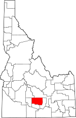
Adjacent counties:
Blaine  Camas  Gooding  Jerome  Minidoka  

Find in Idaho

Map of the Lincoln County area


Our detail map of Lincoln County shows the Lincoln County, Idaho boundary lines and other interesting items.

Places in Lincoln County, Idaho

  Airports     show all on map

Dietrich Landing Area, Laidlaw Corrals Airport, Reynolds Airport, Shoshone BLM Heliport, Shoshone Landing Area

  Bridges     show all on map

Lone Rock Bridge

  Buildings     show all on map

Bureau of Land Management Shoshone Field Office, Dietrich Fire District, Idaho Department of Transportation, Lincoln County Courthouse, Lincoln County Sheriff's Office, Richfield Fire Protection District, Shoshone City Rural Fire District Station 1, Shoshone City Rural Fire District Station 2, Shoshone Police Department

  Canals     show all on map

700 Drain, Arkoosh Hydro, Byrns Stratton Canal, Detrich Canal, Dietrich Main Canal, East Main Canal, F Waste, High Line Canal, Jim Byrns Slough, Lateral 1076, Lateral 1076A, Lateral 1076A1, Lateral 1096, Lateral 1096A, Lateral 1116, Lateral 1137, Lateral 1150, Lateral 156, Lateral 175, Lateral 175A, Lateral 204, Lateral 2076, Lateral 209, Lateral 2153, Lateral 2157, Lateral 21A, Lateral 21C, Lateral 251, Lateral 252, Lateral 253, Lateral 261, Lateral 290, Lateral 291, Lateral 296, Lateral 296A, Lateral 333, Lateral 343, Lateral 343A, Lateral 350, Lateral 357, Lateral 357A, Lateral 357A1, Lateral 357B, Lateral 357C, Lateral 414, Lateral 423, Lateral 423A, Lateral 442, Lateral 444, Lateral 497, Lateral 498, Lateral 498A, Lateral 498B, Lateral 558, Lateral 558A, Lateral 614, Lateral 700, Lateral 700A1, Lateral 700B, Lateral 702, Lateral 702A, Lateral 702A3, Lateral 702A3B, Lateral 710, Lateral 710A, Lateral 731, Lateral 838, Lateral 838A, Lateral 838B, Lateral 860, Lateral 900, Lateral 912, Lateral 912A, Lateral 916A, Lateral 916B, Lateral 916C, Lateral 916C1, Lateral 916C1A, Lateral 916C1B, Lateral 916C2, Lateral 916C3, Lateral 916C4, Lateral 916E, Lateral 916S, Lateral 917, Lateral 917A, Lateral 925, Lateral 930, Lateral 940, Lateral 964, Lateral 978, Lateral 978A, Lateral 992, Lateral 993A, Lateral 993B, Lateral C, Lateral F, Lateral F1, Lateral H, Lateral H2, Lateral H3, Lincoln Bypass Canal, Lincoln Canal, North Gooding Canal, North Shoshone Canal, Notch Butte Hydro, Richfield Canal, Shorock Hydro, South Waste, West Main Canal

  Craters     show all on map

Black Butte Crater, Black Ridge Crater, The Blow Out, The Crater

  Dams     show all on map

Patterson Dam

  Falls     show all on map

Big Drops, Little Drops

  Flats     show all on map

North Center Lake

  Lakes     show all on map

Antelope Reservoir, Bacon Lake, Big Draw Reservoir, Cliff Lake, Corral Reservoir, Cottontail Lake, Crater Lake, Dry Gulch Reservoir, Dry Rock Lake, Duck Lake, Green Spring Reservoir, Greybull Reservoir, Halfway Lake, Hansen Lake, Hillside Reservoir, Hunt Waterhole, Mac Rae Lake, Mallard Lake, Mud Flat Lake, Mule Shoe Lake, Mustard Lake, New Road Lake, New Years Lake, Nipple Reservoir, One Shot Lake, Owinza Butte Lake, Reed Lake, Rock Lake, Ruiz Lake, Sand Lake, Seep Reservoir, Shale Butte Lake, Sid Lake Number One, Sid Lake Number Two, South Wildhorse Lake, Star Lake, Texas Lake, Tom Gooding Lake, Trinity Lake, Wally Reservoir, West Wildhorse Lake, Zero Lake

  Locales     show all on map

Besslen Station, Brady, Disney, Laidlaw Corrals, Lincoln County Fairgrounds, Marley Station, Preacher Bridge Access Area, Saphom Ruins, Senter, Shale Butte Trappers Cabin, Shale Butte Water Tonk, Star Lake Ranch, Taylor Bear Tracks - Williams Access Area

  Parks     show all on map

Little Drops Recreation Area, Mary L Gooding Memorial Park

  Plains     show all on map

Snake River Plains

  Populated Places     show all on map

Besslen, Burmah, Dietrich, Kimama, Marley, Owinza, Pagari, Richfield, Shoshone, Tunupa

  Post Offices     show all on map

Burns Post Office (historical)

  Ranges     show all on map

Black Butte Hills

  Reservoirs     show all on map

Bailing Reservoir, Banner Reservoir, Bill Reservoir, Blackbird Reservoir, Border Reservoir, Bugler Reservoir, Carlotta Reservoir, Corner Reservoir, Cottonwood Reservoir, Crater Reservoir, Crater Reservoir, Cross Road Reservoir, Crossroad Reservoir, Crossroads Reservoir, Cut Off Reservoir, Daves Reservoir, Deadeye Reservoir, Deer Reservoir, East Monument Reservoir, Elden Reservoir, Flat Top Reservoir, Gooding Reservoir, Horseshoe Reservoir, Iest Reservoir, Jack Reservoir, Johnson Reservoir, Jones Reservoir, Kimama Marsh Reservoir, Kinzie Butte Reservoir, Lake Reservoir, Landmark Reservoir, Little Cottonwood Reservoir, Little Draw Reservoir, Martin Reservoir, Meadowlark Reservoir, Montrose Reservoir, Monument Reservoir, Mustard Reservoir, Northwest Pasture Reservoir, Pintail Reservoir, Portuguese Reservoir, Raft Reservoir, Rattler Reservoir, Rocks Reservoir, Schrike Reservoir, Section Twenty-Eight Reservoir, Seeding Reservoir, Seven Hundred Reservoir, Shoshone Reservoir, Sid Reservoir, Slick Reservoir, Spray Reservoir Number Two, Stewart Reservoir, Teal Reservoir, Three Point Reservoir, Thrush Reservoir, Tumbleweed Reservoir, Twin Oaks Reservoir, Unique Reservoir, Upper Seven-Hundred Reservoir, Water Reservoir, West Monument Reservoir, Wildcat Reservoir

  Schools     show all on map

Dietrich Grade School, Dietrich High School, Dietrich School, Lincoln Elementary School, Lincoln School, Richfield School, Shoshone High School, Shoshone Junior-Senior High School

  Springs     show all on map

Middle Water Hole, Shirley G Spring, Uphill Water Hole

  Streams     show all on map

Cottonwood Slough, Portuguese Creek, Silver Creek, Thunder Creek

  Summits     show all on map

Black Butte, Broken Top Butte, Brown Butte, Crater Butte, Dietrich Butte, Johnson Butte, Kinzie Butte, Monument Butte, Notch Butte, Owinza Butte, Sand Butte, Shale Butte, Sid Butte, Spud Butte, Twin Oaks, Wildhorse Butte

  Valleys     show all on map

Timber Gulch

  Wells     show all on map

Arkoosh Wendell Well, Association Well, Black Ridge Well, Brailsford Well, Clark Well, Dietrich Allotment Well, Dietrich Butte Well, Jones Wendell Well, Lincoln Well, Monument Butte Well, Owinza Well, Pagari Well, Rocks Well, Stage Barn Well (historical),

Lincoln County, Idaho Population By Race (2012 estimate)

RacePopulation
WhiteLincoln County White population 5,0645,064  
MixedLincoln County Mixed population 7979
BlackLincoln County Black population 2626
AsianLincoln County Asian population 2121
Hawaiian & Pacific IslanderLincoln County Hawaiian & Pacific Islander population 55

Additional population tables :
State population table
Idaho population by county