Camas County, Idaho Basics:


Camas County Idaho - Government Site

Population: 1,076
Area: 1074 square miles
County seat: Fairfield
Area code(s) in use: 208
Time zone: MST
High school graduate or higher: 81.7%
Bachelor's degree or higher: 21.6%
Median household income: $40,515
Persons in poverty: 15.0%
Home ownership rate: 65.9%
Mean travel time to work: 29.6 minutes
Adjacent counties:
Blaine  Elmore  Gooding  Lincoln  

Find in Idaho

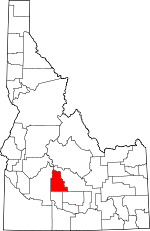
Map of the Camas County area


Our detail map of Camas County shows the Camas County, Idaho boundary lines and other interesting items.

Places in Camas County, Idaho

  Airports     show all on map

Camas County Airport, Magic Reservoir Airport, Tracy Ranch Airport

  Areas     show all on map

Rives Placer (historical), Rollins Placer (historical)

  Bars     show all on map

Jones Bar, Lightfoot Bar

  Basins     show all on map

Big Hole, Ross Fork Basin

  Bends     show all on map

Weavers Hole

  Bridges     show all on map

Blaine Bridge, Macon Sheep Bridge

  Buildings     show all on map

Big Smoky Work Center, Camas County - Fairfield Volunteer Fire District, Camas County Sheriff's Office, West Magic Fire District Station 1, West Magic Fire District Station 2

  Canals     show all on map

Richfield Main Canal

  Cemeteries     show all on map

Corral Cemetery, Hill City Cemetery, Manard Cemetery, Mountain View Cemetery

  Cliffs     show all on map

Big Bluff, Elk Point, Windmill Bluff

  Craters     show all on map

The Pothole

  Dams     show all on map

Dry Wash Dam, Kelly Dam, McHan Dam, Mormon Dam, Spring Creek Dam

  Flats     show all on map

Bowman Flat, Camas Prairie, Davis Flat, Ditto Flat, Little Flat, Macon Flat, Squaw Flat

  Forests     show all on map

Sawtooth National Forest

  Gaps     show all on map

Boardman Pass

  Lakes     show all on map

Bass Lakes, Goat Lake, Heart Lake, Little Bear Lake, Macon Lake, Paradise Lake, Perkons Lake, Ross Fork Lakes, Smoky Dome Lakes, Snowslide Lakes

  Locales     show all on map

Baumgartner Campground, Big Smoky Campground, Big Smoky Guard Station, Bighorn Campground, Bowns Campground, Camas Cow Camp, Canyon Campground, Carrie Creek Campground, Corral, Crows Nest, Dean Camp, Ear Creek Sheep Corral, Fir Grove Ranch, Five Points Campground, Gooding Corrals, Gooding Cow Camp, Indian Hole, Little Smokey Patrol Cabin, Little Smoky Campground, Mormon Reservoir Access Area, Narrows Campground, Pioneer Campground, Pole Corral, Priest Station, River Bend Campground, Skeleton Campground, Soldier Forest Camp, Soldier Mountain Ski Area

  Mines     show all on map

Alma Mine, Axolotl Mine, Buttercup Mine, Carrie Leonard Mine, El Oro Mine, Five Points Mine, Galore Mine, Happy Day Mine, Horn Silver Mine, King of the West Mine, Last Chance Mine, Old Sam Mine, Princess Blue Ribbon Mine, Red Horse Mine, Richard Allen Mine, Silver Star Mine, Tip Top Mine, Tyrannis Mine

  Parks     show all on map

Deer Park

  Pillars     show all on map

Marshall Peak

  Populated Places     show all on map

Blaine, Carrietown, Fairfield, Hill City, Indian Head Rock, Macon, Magic, Punkin Corner, Rands, Selby, Soldier

  Ranges     show all on map

Mount Bennett Hills

  Reserves     show all on map

Camas Prairie Centennial Marsh Wildlife Management Area

  Reservoirs     show all on map

Buck Brush Reservoir, Buckbrush Reservoir, Choke Cherry Reservoir, Chokecherry Reservoir, Cirque Reservoir, Cougar Reservoir, Crows Nest Reservoir, Darrah Reservoir, Divide Reservoir, Fawn Reservoir, Flat Tire Reservoir, Floyds Reservoir, Granite Butte Reservoir, Grante Butte Reservoir, Grouse Reservoir, Johns Reservoir, Kelly Reservoir, Little Magic Reservoir, Lone Rock Reservoir, Magpie Reservoir, McHan Reservoir, Mormon Reservoir, Neilsen Reservoir, One Hour Reservoir, Paddock Reservoir, Reserve Reservoir, Road Reservoir, Saddle Reservoir, Sheep Lake, Snake Reservoir, Spring Creek Reservoir, Summit Reservoir, Thorn Creek Reservoir, Twin Reservoir

  Ridges     show all on map

Cold Spring Ridge, Elk Ridge

  Schools     show all on map

Camas County Elementary-Junior High School, Camas County High School, Elk Creek School, Manard School, Springdale School, Willow Creek School

  Springs     show all on map

Barrel Water Hole, Big Spring, Broken Tank Spring, Brownell Spring, Chicken Spring, Cold Spring, Cold Spring, Cow Heaven Spring, Deer Spring, Elk Creek Hot Spring, Erma Spring, Eusebio Spring, Gridley Spring, Hash Spring, Horn Spring, Hot Spring, Leahy Spring, Lightfoot Hot Springs, Marsh Spring, Metcalf Spring, Mud Spring, Northside Spring, Pofferman Spring, Preis Hot Spring, Radarmacher Spring, Simms Spring, Skillern Hot Springs, Tom Gooding Spring, Water Cress Spring, Worswick Hot Springs

  Streams     show all on map

Barlow Creek, Basalt Creek, Bass Creek, Bear Creek, Beaver Creek, Beaver Creek, Belle Creek, Big Deer Creek, Big Peak Creek, Big Smoky Creek, Blackhorse Creek, Blowout Creek, Bluff Creek, Boardman Creek, Bowns Creek, Bremner Creek, Bridge Creek, Bridge Creek, Brush Creek, Burnt Log Creek, Buttercup Creek, Calf Creek, Camas Creek, Camp Creek, Cannonball Creek, Carrie Creek, Cherry Creek, Chicken Creek, Chimney Creek, Conant Creek, Cookstove Creek, Cooper Creek, Corral Creek, Cow Creek, Dairy Creek, Daugherty Creek, Deadwood Creek, Deer Creek, Devils Dive Creek, Ear Creek, East Dempsey Creek, East Fork Beaver Creek, East Fork Big Peak Creek, East Fork Corral Creek, East Fork Elk Creek, East Fork Fish Creek, East Fork Skeleton Creek, East Fork Threemile Creek, East Fork Worswick Creek, Elk Creek, Elk Creek, Emma Creek, Five Points Creek, Fletcher Creek, Free Gold Creek, Fricke Creek, Friedman Creek, Goat Creek, Gold Run Creek, Grindstone Creek, Headquarters Camp Creek, Hearn Creek, Helen Creek, High Creek, Hole-In Wall Creek, Hot Spring Creek, Iron Mountain Creek, Johnson Creek, Jumbo Creek, King of the West Creek, Knowlton Creek, Lansing Creek, Lava Creek, Lawrence Creek, Liberal Creek, Lick Creek, Lightning Creek, Line Creek, Little Bear Creek, Little Beaver Creek, Little Deer Creek, Little Fish Creek, Little Jumbo Creek, Little Pinyon, Little Skeleton Creek, Little Smoky Creek, Log Creek, Loggy Creek, Long Tom Creek, Mays Creek, McCarter Creek, McKinney Creek, McMahan Creek, Miller Creek, Minear Creek, Minnehaha Creek, Monument Gulch Creek, Mule Creek, Narrow Creek, Nebraska Creek, Nettle Creek, North Fork Big Smoky Creek, North Fork Cherry Creek, North Fork Ross Fork, North Fork Soldier Creek, Northside Slough, O P Creek, Owens Creek, Paradise Creek, Pepper Creek, Perkons Creek, Phillips Creek, Pine Creek, Placer Creek, Poison Creek, Polson Creek, Powell Creek, Red Rock Creek, Reedy Creek, Roanhide Creek, Rosetta Creek, Ross Fork, Rough Creek, Salt Creek, Salt Log Creek, Sampson Creek, Sawmill Creek, Sawmill Creek, Severe Creek, Sheep Creek, Sheep Creek, Silver Creek, Skeleton Creek, Skillern Creek, Skunk Creek, Snowslide Creek, Soldier Creek, South Fork Ross Fork, South Fork Soldier Creek, Spare Creek, Spring Creek, Steep Creek, Stewart Creek, Stovepipe Creek, Threemile Creek, Tyrannis Creek, Vienna Creek, Wardrop Creek, West Fork Big Peak Creek, West Fork Big Smoky Creek, West Fork Corral Creek, West Fork Elk Creek, West Fork Fish Creek, West Fork Grindstone Creek, West Fork Salt Creek, West Fork Skeleton Creek, West Fork Threemile Creek, West Fork Willow Creek, Williams Creek, Williams Creek, Willow Creek, Wine Creek, Worswick Creek

  Summits     show all on map

Baker Peak, Big Peak, Cannonball Mountain, Cline Hill, Couch Summit, Davis Mountain, Fir Grove Mountain, Fleck Summit, Horse Mountain, Iron Mountain, Johnson Hill, Johnson Hill, Jumbo Mountain, Liberal Mountain, Lookout Point, Newman Peak, Paradise Peak, Ross Peak, Sheep Point, Skillern Peak, Smoky Dome, Sydney Butte, The Knob, The Knob, Twin Peaks, Two Point Mountain, Wells Summit

  Trails     show all on map

Bremner Trail

  Valleys     show all on map

Alpine Gulch, Bear Gulch, Bird Canyon, Blind Canyon, Boyer Gulch, Brush Canyon, Edwards Gulch, Gardner Gulch, Housman Gulch, Jones Gulch, Lava Canyon, Little Pinyon, Long Gulch, Long Gulch, McCan Gulch, McDonald Gulch, McHan Gulch, McKay Gulch, Mill Canyon, Mill Canyon, Narrow Canyon, Perkins Gulch, Pinyon Gulch, Roberts Draw, Royal Gorge, Shoots Gulch, Smoky Dome Canyon, Thaw Draw, Timber Gulch, Wash Canyon, Weeks Gulch, White Rag Gulch, Wood Gulch

  Woods     show all on map

Fir Grove,

Camas County, Idaho Population By Race (2012 estimate)

RacePopulation
WhiteCamas County White population 1,0231,023  
MixedCamas County Mixed population 3434
American IndianCamas County American Indian population 109
BlackCamas County Black population 55
AsianCamas County Asian population 33
Hawaiian & Pacific IslanderCamas County Hawaiian & Pacific Islander population 11

Additional population tables :
State population table
Idaho population by county