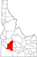
Elmore County, Idaho Basics:


Elmore County Idaho - Government Site

Population: 26,292
Area: 3075 square miles
County seat: Mountain Home
Area code(s) in use: 208
Time zone: MST
High school graduate or higher: 85.0%
Bachelor's degree or higher: 15.3%
Median household income: $43,886
Persons in poverty: 15.6%
Home ownership rate: 65.2%
Mean travel time to work: 18.1 minutes


Adjacent counties:
Ada  Blaine  Boise  Camas  Custer  Gooding  Owyhee  Twin Falls  
Find in Idaho

Map of the Elmore County area


Our detail map of Elmore County shows the Elmore County, Idaho boundary lines and other interesting items.

Places in Elmore County, Idaho

  Airports     show all on map

Atlanta Airport, Bennett Airport, Glenns Ferry Municipal Airport, Graham-US Forest Service Airport, Grindstone Ag Airport, Mountain Home Municipal Airport, Pine Airport, Red Baron Airpark, Smith Prairie Airport, Weatherby Landing Area, Weatherby-US Forest Service Airport

  Areas     show all on map

Lazy Grove, The Cottonwoods, Water Holes

  Bars     show all on map

Big Foot Bar

  Basins     show all on map

Bennett Creek Basin, China Basin, Devils Hole, Pasadena Valley, Smith Prairie, Teapot Basin

  Bays     show all on map

Big Water Hole

  Benches     show all on map

Lower Bench

  Bends     show all on map

Indian Point

  Bridges     show all on map

Slick Bridge

  Buildings     show all on map

Atlanta Rural Fire Department, Elmore County Sheriff's Office, Glenns Ferry Fire Department, Glenns Ferry Police Department, Mountain Home Air Force Base Fire Department Station 1, Mountain Home Air Force Base Fire Department Station 2, Mountain Home Police Department, Mountain Home Rural Volunteer Fire Department, Mountain Home Volunteer Fire Department Station 1, Mountain Home Volunteer Fire Department Station 2, Mountain Home Volunteer Fire Department Station 3, Mountain Home Volunteer Fire Department Station 4

  Canals     show all on map

Basin Lateral, Basin Siphon, East Side Canal, Feeder Canal, Flying H Canal, King Hill Lateral, King Hill Main Canal, Lamberton Canal, Lateral Y-12, Lateral Y-9, Low Line Canal, Middle Line Canal, Miller Canal, Old Lamberton Canal (historical), Pierce Ditch, Ricke Ditch, Sunleaf Siphon (historical), Walker Ditch, West Side Canal

  Capes     show all on map

Indian Point

  Cemeteries     show all on map

Mountain View Cemetery

  Census     show all on map

Mountain Home Air Force Base Census Designated Place

  Channels     show all on map

The Narrows

  Churches     show all on map

Mountain Home Christian Center

  Cliffs     show all on map

Big Bluff

  Craters     show all on map

Crater Rings

  Crossings     show all on map

Little Canyon Creek Longs Crossing, Three Island Crossing

  Dams     show all on map

Anderson Ranch Dam, Cow Creek Dam, Francis Dam, Fraser Dam (historical), Greene Tree Dam, Groefsema Dam, Hall Dam, Hoffman and Duffy Dam, Hot Springs Number Two Dam, Little Camas Dam, Little Canyon Dam, Long Tom Dam, Mountain Home Dam, Olson Dam, Rhead Dam, Taylor Dam, Teapot-Lower Dam, Teapot-Upper Dam, Trail Dam, Trail Diversion Dam, Walker Dam, Watson Dam

  Falls     show all on map

Crane Falls (historical), Deadman Falls

  Flats     show all on map

Alexander Flats, Babs Flat, Ballinger Flat, Barber Flat, Chalk Flat, Chattin Flat, Clover Hollow, Cougar Flat, Deadman Flat, Deadman Flat, Goodman Flat, High Prairie, Jolley Flat, Little Camas Prairie, Little Fiddler Flat, Little Sage Hen Flat, Moores Flat, Pury Flat, Sage Hen Flat, Slade Flat, Sproule Flat, The Pasture, White Flat, Wilson Flat

  Gaps     show all on map

Dixie Summit, High Pass, Windy Gap

  Hospitals     show all on map

Elmore Medical Center, United States Air Force Hospital - Mountain Home Air Force Base

  Islands     show all on map

Schoffs Island, Sparlin Island, Tyrrel Island (historical)

  Lakes     show all on map

Alidade Lake, Arrowhead Lake, Azure Lake, Big Lookout Lake, Big Rainbow Lake, Big Roaring River Lake, Big Trinity Lake, Blue Jay Lake, Blue Jay Lake, Borden Lake, Browns Lake, Camp Lake, Chickadee Lake, Cliff Lake, Confusion Lake, Corbus Lake, Dandy Lake, Danskin Lake, Diamond Lake, Fiddle Lake, Glacier Lake, Green Island Lake, Grouse Lakes, Heart Lake, Heart Lake, Hideway Lake, Indian Hole Pond, Island Lake, Johnson Lake, Kerosene Lake, Lake Ingeborg, Leggit Lake, Little Lookout Lake, Little Rainbow Lake, Little Roaring River Lake, Little Spangle Lake, Little Trinity Lake, Lodgepole Lake, Low Pass Lake, Middle Rainbow Lake, North Star Lake, Pancho Lake, Pats Lake, Plummer Lake, Potter Lake, Rock Island Lake, Scenic Lake, Slide Lake, Smith Creek Lake, Snowbank Lake, Spangle Lake, Spangle Lakes, Surprise Lake, The Hole, Timpa Lake, Triangle Lake, Twin Sisters Lakes, Warrior Lakes

  Locales     show all on map

Abbot Campground, Atlanta Guard Station, Atlanta Power Station, Atlanta Recreation Site, Bennett Patrol Cabin Site, Bennett Ranch, Berry Ranch, Big Roaring River Lake Campground, Big Trinity lake Campground, Bird Creek Campground, Castle Rock Campground, Chalk Spur (historical), Chaparral Campground, Cold Spring Campground, Cow Creek Forest Camp, Curlew Creek Recreation Site, Danskin Guard Station, Deadman Cabin, Deer Creek Boat Ramp, Deer Park Campground, Devils Dive, Devils Playground, Dixie Ranch, Dog Creek Campground, Dutch Creek Forest Service Station, Dutch Creek Guard Station, Elk Creek Boat Ramp, Elk Creek Exclosure, Elk Creek Recreation Site, Elk Spring Campground, Evans Creek Campground, Fall Creek Lodge, Fall Creek Recreation Site, Forest Camp, Fourmile Campground, Gardner Gulch Corral, Graham Guard Station, Granite Spring Campground, Halls Ferry (historical), Ice Springs Campground, Idaho Outdoor Assn Campground, Idaho State Highway Maintenance Station, Johnson Creek Campground, Kelley Creek Corral, Lester Creek Forest Service Station, Lime Creek Campground, Little Camas Recreation Site, Little Camas Reservoir Access Area, Little Roaring River Lake Campground, Little Trinity Lake Campground, Little Wilson Creek Campground, Long Gulch Guard Station, Long Tom Ranch, Loveridge Bridge Access Area, McGinness Ranch, Medbury Ferry, Ninemeyer Campground, North Park, Overlook Mill, Pilgrim Stage Station Historic Site, Pine AIrport Boat Ramp, Pine Recreation Site, Powerplant Campground, Queens River Campground, Rattlesnake Campground, Riverside Campground, Rocky Bar Guard Station, Seven L Ranch, Shake Creek Ranger Station, Shake Creek Recreation Site, South Park, Stardust Plaza, Sunnyside, The Roost, Thomson Ranch, Three-Island Crossing Access Area, Tipton Flat Campground, Trinity Lakes Guard Station, Troutdale Campground, View Point, View Point, Willow Creek Campground, Willow Creek Guard Station, Willow Ranch, Yuba City (historical)

  Military     show all on map

Mountain Home Air Force Base

  Mines     show all on map

Bonaparte Mine, Daley Con Mines, Franklin Mine, Marsh Creek Mine, Minerva Mine, Monarch Mine, Reber Mine, Tolache Mine

  Parks     show all on map

Carl Miller Park, East Side Park, Memorial Park, Oregon Trail Historical Marker, Railroad Park, Richard Aguirre Park, Soldier Mountain Game Preserve, Three Island Crossing State Park, Three Island State Park, Trueblood Wildlife Area

  Pillars     show all on map

Cathedral Rocks, Skull Rock

  Populated Places     show all on map

Alturas City (historical), Atlanta, Castle Rocks, Chalk Cut, Cleft, Dixie, Emigrant Crossing, Featherville, Glenns Ferry, Hammett, King Hill, Mayfield, Mountain Home, Paradise Hot Springs, Pine, Prairie, Reclamation Village, Reverse, Rocky Bar, Sebree, Spanish Town (historical), Steamboat Rock, Stout Crossing

  Post Offices     show all on map

Pine Post Office (historical), Rocky Bar Post Office (historical)

  Ranges     show all on map

Danskin Mountains, Soldier Mountains, Trinity Mountains

  Rapidss     show all on map

Ninefoot Rapids (historical)

  Reserves     show all on map

Anderson Ranch Big Game Range, C J Strike Wildlife Management Area, Clover Creek Wildlife Habitat Area, Glenns Ferry Wildlife Habitat Area, Ted Trueblood Wildlife Habitat Area

  Reservoirs     show all on map

Anderson Ranch Reservoir, Arrowrock Reservoir, Blair Trail Reservoir, Cow Creek Reservoir, Fraser Reservoir (historical), Hot Springs Creek Reservoir, John Hoffman Reservoir, Keith Reservoir, Lamberton Reservoir, Little Camas Reservoir, Long Tom Reservoir, Lower Teapot Reservoir, Morrow Reservoir, Mountain Home Reservoir, Upper Teapot Reservoir, Walker Reservoir

  Ridges     show all on map

Burnt Ridge, Pony Ridge

  Schools     show all on map

Atlanta School, Childrens House Montessori School, Incorporated, County Line School, East Elementary School, Elmore County Alternative Center, Faith Lutheran School, Glenns Ferry Elementary, Glenns Ferry Junior-Senior High School, Hayland School (historical), Mountain Home Air Force Base Intermediate School, Mountain Home Air Force Base Junior High School, Mountain Home Air Force Base Primary School, Mountain Home Junior High School, Mountain Home Senior High School, North Elementary School, North Elementary School, Pasadena Valley School, Prairie Elementary - Junior High School, West Elementary School

  Springs     show all on map

Abbott Springs, Atlanta Hot Springs, Bainbridge Spring, Bancroft Springs, Beer Can Spring, Bell Mare Spring, Berneathy Spring, Blackhawk Spring, Bourbon Spring, Buckbrush Spring, Bullet Spring, Cedar Spring, Chalk Spring, Chattanooga Hot Spring, Cold Spring, Commerford Springs, Cook Spring, Corker Springs, Cottonwood Springs, Coyote Spring, Craster Spring, Daveys Spring, Doe Spring, Echo Spring, Frenchman Spring, Goat Spring, Granite Spring, Ground Hog Spring, Hat Spring, High Spring, Hog Creek Spring, Hot Springs, Ice Springs, Iron Spring, Jack Spring (historical), Lansing Springs, Latty Hot Spring, Lester Creek Springs, Light Spring, Lone Tree Spring, McFarney Spring, McGuire Spring, Montrose Spring, Moores Spring, Mud Spring, Mud Springs, Orr Springs, Parker Spring, Pilgrim Spring, Prince Albert Spring, Rattlesnake Spring, Rattlesnake Springs, Rustican Spring, Scrub Spring, Simpkins Spring, Sterpernell Spring, Tate Spring, Teapot Spring, Thoroughbred Spring, Timmons Field Spring, Tommy Field Spring, Twin Deer Springs, Twin Springs, Warm Spring, Weatherby Springs, Whiskey Spring, Whitson Spring

  Streams     show all on map

Adams Creek, Aden Creek, Alexander Creek, Alidade Creek, Alkali Creek, Alta Creek, Anderson Creek, Antelope Creek, Arrastra Creek, Arrastra Creek, Badger Creek, Badger Creek, Badger Creek, Baker Creek, Bald Mountain Creek, Ballentyne Creek, Basque Creek, Bayhouse Creek, Bear Creek, Bear Creek, Bear Hole Creek, Beaver Creek, Beaver Creek, Bell Mare Creek, Bender Creek, Bennett Creek, Big Deer Creek, Big Fiddler Creek, Big Five Creek, Big Horse Creek, Big Spring Creek, Big Springs Creek, Billy Creek, Bird Creek, Biswell Creek, Black Warrior Creek, Blue Jay Creek, Bock Creek, Boiler Grade Creek, Bounds Creek, Breadwinner Creek, Browns Creek, Browns Creek, Buck Creek, Buck Creek, Buckhorn Creek, Buffalo Creek, Burgy Creek, Burnt Creek, Byron Creek, Cahhah Creek, Camp Creek, Camp Creek, Campo Creek, Canyon Creek, Case Creek, Casey Creek, Castle Creek, Castle Rock Creek, Cat Creek, Cayuse Creek, Cayuse Creek, Charcoal Creek, Chicken Creek, Chimney Creek, China Fork, Clover Creek, Cold Spring Creek, Cold Springs Creek, Corbus Creek, Corder Creek, Corker Creek, Corral Creek, Corral Creek, Corral Creek, Corral Creek, Cottonwood Creek, Cottonwood Creek, Cougar Creek, Cove Creek, Cow Creek, Cow Creek, Cow Creek, Cow Creek, Crank Creek, Crooked Creek, Crown Creek, Curlew Creek, Dawes Creek, Dead Horse Creek, Deadman Creek, Deadman Creek, Deadman Creek, Decker Creek, Deep Creek, Deer Creek, Deer Creek, Deer Creek, Deer Heaven Creek, Devils Creek, Devils Hole Creek, Ditto Creek, Dive Creek, Dive Creek, Dixie Creek, Dog Creek, Dollar Creek, Don Creek, Dry Buck Creek, Dry Creek, Dry Creek, Dutch Creek, Dutch Frank Creek, Eagle Creek, East Fork Bell Mare Creek, East Fork Bennett Creek, East Fork Cold Springs Creek, East Fork Elk Creek, East Fork Fall Creek, East Fork James Creek, East Fork Kelley Creek, East Fork Long Tom Creek, East Fork Roaring River, East Fork Sheep Creek, East Fork Slater Creek, East Fork Smith Creek, East Fork Swanholm Creek, East Fork Yuba River, Echo Creek, Edna Creek, Elk Creek, Elk Creek, Elk Creek, Evans Creek, Fairview Creek, Fall Creek, Fall Creek, Feather River, Fezip Creek, Fir Creek, Fire Creek, Flat Creek, Flint Creek, Fly Creek, Flytrip Creek, Fornham Creek, Geum Creek, Goat Creek, Granite Creek, Granite Creek, Grape Creek, Graves Creek, Grays Creek, Green Creek, Grouse Creek, Grouse Creek, Grouse Creek, Grouse Creek, Guay Creek, Gunsight Creek, Haypress Creek, Heather Creek, Hell Hole Creek, Herrin Creek, Hog Creek, Honey Creek, Horse Heaven Creek, Horsefly Creek, Hot Creek, Hot Springs Creek, Hutton Creek, Jack Creek, Jack Creek, Jackass Creek, James Creek, Jefferson Creek, Joe Daley Creek, Johnson Creek, Johnson Fork, Kelley Creek, Kid Creek, King Creek, King Hill Creek, Knox Creek, La Moyne Creek, Lake Creek, Lake Creek, Lambing Creek, Lava Creek, Left Fork Tally Creek, Leggit Creek, Lester Creek, Lime Creek, Lime Creek, Lincoln Creek, Little Camas Creek, Little Canyon Creek, Little Cayuse Creek, Little Deer Creek, Little Fiddler Creek, Little Grouse Creek, Little Horse Creek, Little Pierce Creek, Little Queens River, Little Rattlesnake Creek, Little Wilson Creek, Little Wood Creek, Lodgepole Creek, Loftus Creek, Long Tom Creek, Lost Man Creek, Louse Creek, Louse Creek, Lynx Creek, Madison Creek, Magpie Creek, Malad River, Maniece Creek, Marsh Creek, Mattingly Creek, Maxfield Creek, McGuire Creek, McKay Creek, McLeod Creek, McPhearson Creek, Meadow Creek, Mennecke Creek, Middle Fork Corbus Creek, Middle Fork Grouse Creek, Middle Fork Lime Creek, Middle Fork Roaring River, Middle Parks Creek, Mill Creek, Mill Creek, Mineral Creek, Mink Creek, Misfire Creek, Monroe Creek, Montezuma Creek, Moores Creek, Mud Springs Creek, Mule Creek, Myrtle Creek, Myrtle Creek, Nanny Creek, Negro Creek, Neinmeyer Creek, Nevins Creek, Nibbler Creek, Ninemeyer Creek, No Name Creek, North Fork Deer Creek, North Fork Grouse Creek, North Fork Lime Creek, North Fork Steel Creek, North Fork Trinity Creek, Overlook Creek, Packer Creek, Packsaddle Creek, Paradise Creek, Parks Creek, Pete Creek, Phifer Creek, Pierce Creek, Pine Creek, Pinto Creek, Pitch Creek, Plantation Creek, Pole Creek, Pole Creek, Pony Creek, Pony Creek, Pool Creek, Porcupine Creek, Queens River, Rabbit Creek, Rabbit Creek, Rainbow Creek, Rattlesnake Creek, Rattlesnake Creek, Rattlesnake Creek, Rattlesnake Creek, Red Warrior Creek, Regina Creek, Repeat Creek, Right Creek, Road Creek, Roaring River, Robert E Lee Creek, Robin Creek, Rock Creek, Rock Creek, Rock Creek, Roost Creek, Rough Creek, Rough Creek, Ruby Creek, Ryegrass Creek, Salix Creek, Salt Creek, Sand Creek, Sawmill Creek, Sawmill Creek, Scenic Creek, Scotch Creek, Scott Creek, Senator Creek, Shake Creek, Sheep Creek, Sheldon Creek, Silver Creek, Silverton Creek, Simmons Creek, Slater Creek, Slater Creek, Slickear Creek, Smith Creek, Smith Creek, Snake Creek, Snowslide Creek, Snowslide Creek, Snyder Creek, Soap Creek, Soles Rest Creek, South Fork Boise River, South Fork Corbus Creek, South Fork Deer Creek, South Fork Grouse Creek, South Fork Lime Creek, South Fork Rock Creek, South Fork Sheep Creek, South Fork Whiskey Jack Creek, Spring Creek, Spring Creek, Sprout Creek, Squaw Creek, Station Creek, Stavley Creek, Steel Creek, Steel Creek, Steep Creek, Steppe Creek, Straight Creek, Strawberry Creek, Swanholm Creek, Syrup Creek, Tally Baker Creek, Taylor Creek, Thompson Creek, Thorn Creek, Thorn Creek, Thorn Creek, Three Forks, Tiger Creek, Tiger Creek, Timber Creek, Timpa Creek, Tipton Creek, Tollgate Creek, Towne Creek, Townsend Creek, Trail Creek, Trail Creek, Trail Creek, Trail Creek, Trail Creek, Trail Creek, Trapper Creek, Trinity Creek, Tripod Creek, Vaughn Creek, Wagontown Creek, Warbois Creek, Washboard Creek, West Dempsey Creek, West Fork Bell Mare Creek, West Fork Cold Springs Creek, West Fork Fall Creek, West Fork James Creek, West Fork Kelley Creek, West Fork King Hill Creek, West Fork Long Tom Creek, West Fork Lost Man Creek, West Fork Shake Creek, West Fork Slater Creek, West Parks Creek, West Warrior Creek, Whiskey Jack Creek, Whitney Creek, Wild Horse Creek, Williams Creek, Willow Creek, Willow Creek, Willow Creek, Willowdale Creek, Wilson Creek, Wilson Creek, Windy Creek, Wood Cabin Creek, Wood Creek, Wood Creek, Woodtick Creek, Wren Creek, Yellow Pine Creek, Yuba River

  Summits     show all on map

Bald Mountain, Bennett Mountain, Big Buck Mountain, Black Mesa, Blacknose Mountain, Blizzard Mountain, Browns Peak, Cat Creek Summit, Cayuse Point, Chattin Hill, Danskin Peak, Deer Heaven Mountain, Deer Mountain, Dog Mountain, Dorsey Butte, East Warrior Peak, Flat Top Mountain, Flatiron Mountain, Flint Mesa, Glens Peak, Gopher Knoll, Grand Mountain, Granite Mountain, Granite Mountain, Grape Mountain, Grey Lock Peak, Greylock Mountain, Grindstone Butte, Grouse Butte, Gunsight Peak, Horse Ranch Mountain, House Mountain, James Creek Summit, Kings Crown, Krall Mountain, Lava Mountain, Little Fiddler, Lockman Butte, Mattingly Peak, Medbury Hill, Mount Everly, Nahneke Mountain, Packer Butte, Packer Butte, Picket Mountain, Plummer Peak, Rattlesnake Mountain, Red Mountain, Sheep Mountain, Smoky Peak, Sprout Mountain, Steel Mountain, Sugar Bowl, Swanholm Peak, Tackobe Mountain, Teapot Dome, Three Point Mountain, Tollgate Hill, Trinity Mountain, Twentymile Butte, West Warrior Peak, Wood Creek Mountain

  Swamps     show all on map

Dismal Swamp

  Towers     show all on map

KLVJ-AM (Mountain Home), KLVJ-FM (Mountain Home)

  Trails     show all on map

Black Warrior Creek Trail, Devils Creek Trail, Hot Springs Creek Trail, Roaring River Trail, Sheep Drive Trail, Yuba River Trail

  Valleys     show all on map

Abbot Gulch, Ada Gulch, Baker Gulch, Barker Gulch, Bear Gulch, Bear Gulch, Bear Gulch, Beaverdam Gulch, Bend Gulch, Big Gulch, Big Pilgrim Gulch, Big Water Gulch, Bird Gulch, Black Canyon, Blackburn Gulch, Blake Gulch, Bronco Gulch, Browns Gulch, Browns Gulch, Buck Gulch, Buckbrush Draw, Burns Gulch, Caldwell Gulch, Camp Gulch, Camp Gulch, Cannon Gulch, Casey Gulch, Cassia Gulch, Chalk Gulch, Cherry Gulch, Clark Gulch, Dare Gulch, Deadman Canyon, Deer Gulch, Democrat Gulch, Dixie Gulch, Dixie Gulch, Dobson Gulch, Dry Gulch, Ellis Gulch, Emigrant Cove, Fern Gulch, Fox Gulch, Frog Hollow, Gem Gulch, Guess Gulch, Hall Gulch, Hardscrabble Gulch, Hawk Gulch, Joan Gulch, Kodak Gulch, Little Pilgrim Gulch, Little Water Gulch, Lockman Gulch, Log Chute Gulch, Long Gulch, Long Gulch, Long Gulch, Lotah Gulch, Lupine Gulch, McIntyre Draw, Mule Gulch, Murphy Gulch, Nichols Gulch, North Fork Valley, Ok Gulch, Pine Gulch, Pole Gulch, Porcupine Gulch, Price Gulch, Quartz Gulch, Raspberry Gulch, Roberts Gulch, Rosevear Gulch, Rough Gulch, Russel Gulch, Sawmill Gulch, Schoolhouse Gulch, Sedum Gulch, Skelton Gulch, Slide Gulch, Sloans Gulch, Smith Draw, South Fork Gulch, Steep Gulch, Stevens Gulch, Swain Gulch, Swiss Valley, Tacket Gulch, Teetors Gulch, Timber Gulch, Van Gulch, Virginia Gulch, Walker Gulch, Warm Spring Gulch, Wide West Gulch, Wylie Gulch

  Wells     show all on map

Wilson Well (historical),

Elmore County, Idaho Population By Race (2012 estimate)

RacePopulation
WhiteElmore County White population 23,40023,399  
MixedElmore County Mixed population 894893
AsianElmore County Asian population 736736
American IndianElmore County American Indian population 394394
Hawaiian & Pacific IslanderElmore County Hawaiian & Pacific Islander population 131131

Additional population tables :
State population table
Idaho population by county