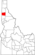
Benewah County, Idaho Basics:


Benewah County Idaho - Government Site

Population: 9,146
Area: 777 square miles
County seat: Saint Maries
Area code(s) in use: 208
Time zone: PST
High school graduate or higher: 87.6%
Bachelor's degree or higher: 13.2%
Median household income: $38,536
Persons in poverty: 14.5%
Home ownership rate: 75.7%
Mean travel time to work: 22.9 minutes


Adjacent counties:
Kootenai  Latah  Shoshone  Spokane (WA)  Whitman (WA)  
Find in Idaho

Map of the Benewah County area


Our detail map of Benewah County shows the Benewah County, Idaho boundary lines and other interesting items.

Places in Benewah County, Idaho

  Airports     show all on map

Benewah Community Hospital Heliport, Saint Maries Municipal Airport, Sky Island Ranch Airport

  Basins     show all on map

North-South Ski Bowl

  Bends     show all on map

Cottonwood Point, Hn'a'yqhn Bend

  Buildings     show all on map

Benewah County Sheriff's Office, Fernwood Rural Fire Protection District, Gateway Fire Protection District, Potlatch Corporation, Saint Maries Ambulance, Saint Maries Fire Protection District Station 1, Saint Maries Police Department, Tensed Ambulance Service, Tensed Rural Fire Protection District, Upriver Ambulance

  Capes     show all on map

Plummer Peninsula

  Cemeteries     show all on map

Evergreen Cemetery, Mountain View Cemetery, Sanders Cemetery, Woodlawn Cemetery

  Census     show all on map

De Smet Census Designated Place, Parkline Census Designated Place

  Cliffs     show all on map

Lotus Point

  Flats     show all on map

Alder Creek Flats, Chetche'mch'm Meadow, Hnmiln Meadow, Sly Meadows

  Gaps     show all on map

Lolo Pass, Parker Pass, Windfall Pass

  Hospitals     show all on map

Benewah Community Hospital

  Lakes     show all on map

Beaver Ponds, Benewah Lake, Chatcolet Lake, Crystal Lake, Goose Heaven Lake, Hidden Lake, Hnchch'li Lake, Porrett Lake, Round Lake, Turtle Lake

  Locales     show all on map

Al Vanderpool Picnic Area, Ch'mi'wes Flat, Chaats'alalqs Grove, Chetkwe'lkw'l Meadow (historical), Chief MOC-TEL-ME Rest Area, Coeur d'Alene Indian Tribal Headquarters, Ferrel, Giant White Pine Recreation Site, Heyburn Youth Camp, Hn'ya)pqi'nn, Hnchdmine'kwe' (historical), Hnmlmulsh Grove, Hnpetptqwe'n, Hnp’ekwle’n Meadow, Hollywood, Muellers Camp, Ni'nsi' Meadow, Ni’lukhwalqw Gap, Saint Maries Country Club, Saint Maries Ranger Station, Saint Maries River Access, Saint Maries River Access, Saint Maries River Access Area, Shadowy Saint Joe Campground, Sq'wdusmn Bench, St'uts'te'wes Point, Taqhalqs Hill, Tilmo

  Mines     show all on map

Old Rainbow Mine

  Parks     show all on map

Grange Park, Heyburn State Park, Mullen Trail Park Historical Monument

  Populated Places     show all on map

Alder Creek, Benewah, Cardwell, Chat'u'washa'lqs Bluff, Chatcolet, De Smet, Emida, Fernwood, Flat Creek, Hawleys Landing, Lotus, Mashburn, Meadowhurst, Milltown, Mowry, North South Ski Bowl, Omega, Parkline, Pedee, Plummer, Plummer Junction, Ramsdell, Renfrew, Riverdale, Rocky Point, Rover, Saint Joe, Saint Maries, Sanders, Santa, Silvertip Landing, Tensed, Tyson Creek Station, Wayland, Willard

  Rapidss     show all on map

Lq'e'ykwe' Rapid

  Reserves     show all on map

Saint Maries Wildlife Management Area

  Reservoirs     show all on map

Bells Lake, Swan Lake

  Ridges     show all on map

Beaver Ridge

  Schools     show all on map

Heyburn Elementary School, Lakeside High School, Plummer Elementary School, Saint Maries High School, Saint Maries Middle School, Saint Maries Seventh-Day Adventist School, Up-River Elementary-Junior High School

  Springs     show all on map

Echo Springs, Hn(os(oskwe' Spring, Tingley Spring, Ts'ts'p'qhwi'lus Spring

  Streams     show all on map

Adams Creek, Ahrs Creek, Alder Creek, Andrews Spring Creek, Beaver Creek, Benewah Creek, Bob Creek, Bond Creek, Brown Creek, Bunnel Creek, Butler Creek, Canyon Creek, Carlin Creek, Carpenter Creek, Charlie Creek, Cherry Creek, Choulson Creek, Conrad Creek, Coon Creek, Coon Creek, Corto Creek, Crystal Creek, Dago Creek, Davis Creek, Day Creek, Deep Creek, Deep Creek, East Fork Charlie Creek, East Fork Emerald Creek, East Fork Meadow Creek, East Fork Mission Creek, Eena Creek, Elip Creek, Ells Creek, Emerald Creek, Fagan Creek, Falls Creek, Finn Creek, Fitzgerald Creek, Flat Creek, Flat Creek, Garveson Creek, Happy Creek, Hardpan Creek, Heinaman Creek, Hill Creek, Hume Creek, Indian Creek, Issick Creek, Jacot Creek, John Creek, Katsuck Creek, Kimta Creek, Lacy Creek, Lemoosh Creek, Little Carpenter Creek, Little John Creek, Little Plummer Creek, Lolo Creek, Martin Creek, Melakwa Creek, Mercury Creek, Merton Creek, Middle Fork Mission Creek, Mineral Creek, Mineral Creek, Mission Creek, Moctileme Creek, Moolock Creek, Mutch Creek, Nehchen Creek, North Fork Alder Creek, North Fork Tyson Creek, Pamas Creek, Pedee Creek, Peterson Creek, Pierce Creek, Pokey Creek, Pollard Creek, Preston Creek, Ramskull Creek, Renfro Creek, Rochat Creek, Rock Creek, Saint Maries River, Santa Creek, Scurry Creek, Sheep Creek, Sheep Creek, Short Creek, Smith Creek, Soldier Creek, South Fork Hangman Creek, South Fork Santa Creek, Stewah Creek, Street Creek, Syringa Creek, Tenas Creek, Thomas Creek, Thorn Creek, Tram Creek, Trout Creek, Tyson Creek, Wadi Creek, West Fork Emerald Creek, West Fork Hugus Creek, West Fork Mission Creek, West Fork Pine Creek, Willow Creek, Willow Creek, Wilson Creek, Windfall Creek

  Summits     show all on map

Beaver Mountain, Carpenter Mountain, Charles Butte, Crane Point, East Dennis, Emida Peak, Fairview Knob, Fitzgerald Peak, Grassy Mountain, Green Mountain, Holaki Knob, Honey Jones Peak, John Point, Kings Peak, Liberty Butte, Lindstrom Peak, Lukwle' Mountain, Marsh Hill, Moses Mountain, Nakarna Mountain, Negro Brown Hill, Nehchen Bluff, O'Neill Hill, Pearson Peak, Peterson Point, Pettis Peak, Plummer Butte, Preston Knob, Reeds Baldy, Rochat Peak, Round Top, Saint Joe Baldy, Saint Maries Peak, Santa Peak, Sharp Top, Shay Hill, Sunset Mountain, Tyson Peak, Watt Hill, West Dennis, Willow Peak, Wilson Mountain

  Towers     show all on map

KOFE-AM (Saint Maries)

  Trails     show all on map

White Pine Scenic Drive

  Tunnels     show all on map

Sorrento Tunnel

  Valleys     show all on map

Ahrs Gulch, Allens Gulch, Bedrock Gulch, Browns Gulch, Cedar Draw, Fire Draw, Hells Gulch, King Valley, Lovell Valley, Miesen Draw, Minaloosa Valley, Phillips Draw, Reeds Gulch, Rock Creek Valley, Slaughterhouse Draw, Stickney Gulch, Wittenburg Draw, Wolf Draw,

Benewah County, Idaho Population By Race (2012 estimate)

RacePopulation
WhiteBenewah County White population 7,9207,920  
American IndianBenewah County American Indian population 805804
MixedBenewah County Mixed population 348347
AsianBenewah County Asian population 3736
Hawaiian & Pacific IslanderBenewah County Hawaiian & Pacific Islander population 99

Additional population tables :
State population table
Idaho population by county