Valley County, Idaho Basics:


Valley County Idaho - Government Site

Population: 9,524
Area: 3665 square miles
County seat: Cascade
Area code(s) in use: 208
Time zone: MST
High school graduate or higher: 91.9%
Bachelor's degree or higher: 34.4%
Median household income: $51,953
Persons in poverty: 10.3%
Home ownership rate: 78.4%
Mean travel time to work: 15.7 minutes
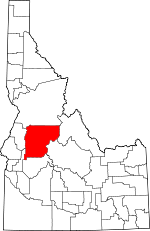
Adjacent counties:
Adams  Boise  Custer  Gem  Idaho  Lemhi  

Find in Idaho

Map of the Valley County area


Our detail map of Valley County shows the Valley County, Idaho boundary lines and other interesting items.

Places in Valley County, Idaho

  Airports     show all on map

Bernard-US Forest Service Airport, Big Creek Airport, Big Creek Heliport, Bruce Meadows Airport, Cabin Creek-US Forest Service Airport, Cascade Airport, Deadwood Dam Airstrip, Donnelly Airport, Flying B Ranch Landing Strip, Hidden Lakes Airport, High Valley Bills Airport, Indian Creek-US Forest Service Airport, Johnson Creek Airport, Krassel-US Forest Service Airport, Landmark-US Forest Service Airport, Mahoney Creek-US Forest Service Airport, McCall Airport, McCall Memorial Hospital Heliport, Mile Hi Landing Strip, Morgan Ranch Airport, Pistol Creek Ranch Landing Strip, Reed Ranch Airport, Soldier Bar-US Forest Service Airport, Stibnite Airport, Taylor Ranch Landing Area, Thomas Creek Airport, Valley County Hospital Heliport, Vines Landing Strip

  Arches     show all on map

Rainbow Rock

  Bars     show all on map

Buckhorn Bar, Coxey Creek Bar, Deadman Bar, Hard Boil Bar, Hospital Bar, Monumental Bar, Over Easy Bar, Soft Boil Bar, Soldier Bar

  Basins     show all on map

Browns Basin, Bucks Basin, Burnt Basin, Cottonwood Basin, Cougar Basin, Deadwood Basin, Goat Basin, Horsethief Basin, Jumbo Basin, Little Sage Hen Basin, Lobauer Basin, Lost Basin, Pen Basin, Scott Valley, Stratton Basin, Towhead Basin, Tranquil Basin, Ucon Basin, Whitehawk Basin

  Bays     show all on map

Duck Bay, Huckleberry Bay, Pilgrim Cove, Wagon Wheel Bay

  Beaches     show all on map

North Beach, Sylvan Beach

  Bends     show all on map

Big Hole, Coxey Hole

  Bridges     show all on map

Bighorn Bridge, Hartsell Bridge, Monumental Bridge, Sheep Bridge, White Creek Bridge

  Buildings     show all on map

Cascade City Fire Department, Cascade Police Department, Cascade Rural Fire Protection District Station 1, Cascade Rural Fire Protection District Station 2, Cascade Rural Fire Protection District Station 3, Donnelly Rural Fire Protection District Donnelly Station, High Valley Fire Protection Association, McCall Fire Protection District, McCall Police Department, Valley County Sheriff's Office, Yellow Pine Fire District

  Canals     show all on map

Boulder Ditch, Center Canal, Cruzen Ditch, East Fork Roseberry Ditch, Gold Fork Canal, Lake Irrigation District Canal, Mahala Ditch, Roseberry Ditch, Spink Barker Ditch, Stringer Ditch, Westside Lake Fork Ditch

  Capes     show all on map

Eureka Point, Kinney Point, Lucks Point, Paradise Point, Picnic Point, Porcupine Point

  Cemeteries     show all on map

Alpha Cemetery, Cottonwood Cemetery, Finn Cemetery, Homes Cemetery, Klines Grave, Pioneer Cemetery, Spink Cemetery

  Census     show all on map

Smiths Ferry Census Designated Place, Yellow Pine Census Designated Place

  Channels     show all on map

Liggett Creek Way, The Narrows

  Cliffs     show all on map

Bear Creek Point, Cox Point, Indian Creek Point, Lightning Point, McFadden Point, Rattlesnake Point, Slick Rock

  Dams     show all on map

Beal Number Three Dam, Boulder Lake Dam, Boulder Meadow Dam, Box Lake Dam, Brown Dam, Browns Pond Dam, Callender Dam, Cascade Dam, Corral Creek Dam, Davis Dam, Deadwood Dam, Eld Dam, Granite Lake Dam, Hait-Upper Dam, Herrick Dam, Hidden Lake Dam, Holbrook Dam, Hollenbeak Dam, Horsethief Basin Dam, Hughes Dam, Jemima K Dam, Jug Creek Dam, Jussila-Bow Dam, Knox Meadow Dam, Koskella Dam, Little Payette Lake Dam, Louie Lake Dam, Molony Dam, Payette Lake Dam, Pitkin Dam, Poro Dam, Rio Vista Dam, Shaw Twins-Upper Dam, Skein Lake Dam, Smalley Dam, Tom J Dam, Tripod Dam, Upper Payette Lake Dam, Warren Diversion Dam, Woodall Dam

  Falls     show all on map

Dagger Falls

  Flats     show all on map

Aquinaldo Flat, Aspen Flat, Ayers Meadows, Big Meadows, Bruce Meadows, Cache Meadows, Caton Meadow, Copeland Flats, Corduroy Meadows, Crane Meadow, Crane Meadow, Crescent Meadow, Dollar Creek Meadow, Dry Buck Meadow, Enos Meadow, Fawn Meadow, Foolhen Meadows, Gold Fork Meadow, Grassy Flat, Harscrabble Pasture, Hennessey Meadow, Jug Meadows, Kiwah Meadow, Lost Meadows, Lower Trapper Flat, Mace Meadows, Mile Flat, Mountain Meadow, Paddy Flat, Phoebe Meadow, Pine Creek Meadow, Poker Meadows, Pony Meadows, Porcupine Flat, Reservoir Flat, Round Meadow, Round Meadow, Sater Meadows, Stewarts Meadow, Stolle Meadows, Stony Meadow, Stover Meadow, Sunflower Flat, Trapper Flat, Tripod Meadow, Tyndall Meadows, Upper Trapper Flat, Wardenhoff Meadows, Wet Meadows

  Forests     show all on map

Payette National Forest

  Gaps     show all on map

Bear Trap Saddle, Big Creek Summit, Blackmare Summit, Buck Saddle, Chilcoot Pass, Cloochman Saddle, Cougar Creek Summit, Cougar Saddle, Deer Creek Pass, Dry Buck Summit, Elk Summit, Fall Creek Saddle, Goldman Cut, Lick Creek Summit, Needles Summit, No Business Saddle, North Fitsum Summit, Profile Gap, Railroad Pass, Rainbow Saddle, Secesh Summit, South Fork Buckhorn Summit

  Hospitals     show all on map

Cascade Medical Center, Saint Luke's McCall Memorial Hospital

  Islands     show all on map

Cougar Island, Shellworth Island, Sugarloaf

  Lakes     show all on map

Anderson Lake, Anns Lake, Artillery Lake, Bear Creek Lake, Bear Lake, Bear Lake, Bernard Lake, Bills Lake, Black Lake, Black Lake, Blackwell Lake, Blue Lake, Blue Lake, Brush Lake, Buck Lake, Buckhorn Lake, Buckhorn Mountain Lake, Burnside Lake, Catherine Lake, Caton Lake, Chilcoot Lake, Cly Lakes, Cougar Lakes, Cow Lake, Crater Lake, Cruzen Pond, Crystal Lake, Curtis Lake, Deep Lake, Dismal Lake, Duck Lake, East Lake, Ellis Lake, Enos Lake, Fish Lake, Fogg Lake, Frog Lake, Golden Lake, Heart Lake, Hidden Lake, Honeymoon Lake, Horton Lake, Hum Lake, Idler Lakes, Jungle Lake, Kennally Lakes, Knox Lake, Lick Lake, Little Summit Lake, Logan Lake, Long Lake, Long Lake, Loon Lake, Lost Lake, Lost Lake, Lost Lakes, Maki Lake, Malony Lake, Marge Lake, Marion Lake, Meadow Creek Lake, Middle Fork Lake, Middle Lake, Milk Lake, Morehead Lake, Mud Lake, North Lake, Norton Lake, Papoose Lakes, Payette Lake, Pearl Lake, Petes Lake, Pistol Lake, Poison Lake, Pot Lake, Potters Pond, Profile Lake, Raft Lake, Rainbow Lake, Rainbow Lakes, Rapid Lake, Rice Lake, Riordan Lake, Roaring Lakes, Rock Lake, Rock Lake, Rock Lake, Roosevelt Lake, Shaw Twin Lakes, Sheepherder Lake, Shell Rock Lake, Shirts Lake, Sisters Lakes, Snowslide Lake, South Lake, Square Top Lake, Squaw Lake, Steamboat Lake, Storm Peak Lake, Stump Lake, Summit Lake, Summit Lake, Summit Lake, Summit Lake, Teardrop Lake, Thirtythree Lake, Trail Lake, Tule Lake, Twentymile Lakes, Vics Lake, Victor Lake, Warm Lake, Warner Pond

  Locales     show all on map

Alice Pittinger Girl Scout Camp, Alpha Grange, Alpine Village, Amanita Campground, Antimony Camp, Arling, Arling Station, Barneys Park Campground, Bear Valley Campground, Bear Valley Patrol Cabin, Belleco, Big Creek Work Center, Big Eddy Campground, Big Snag Campsite, Billy Rice Public Swimming Area, Black Lee Campground, Blackmare Lookout, Blue Point Campground, Boiling Springs Campground, Boiling Springs Work Center, Boundary Creek Recreation Site, Boy Scout Camp Campground, Browns Camp, Bruce Meadows Campground, Buck Mountain Campground, Buckhorn Bar Campground, Buckhorn Campground, Cabarton Station, Cable Hole Campsite, Cameron Campsite, Cameron Ranch, Campbell Creek Recreation Site, Canyon Campground, Cascade Lake 4H Camp, Cascade Ranger Station, Cold Springs Campground, Cold Springs Campsite, Copper Camp, Cozy Cove Campground, Crawford Forest Work Center, Cupp Corral, Dagger Falls Recreation Site, Deadman Campground, Deadwood, Deadwood Lodge, Deer Flat Campground, Dome House Campsite, East Mountain Lookout, Elk Bar Campground, Elk Creek Campground, Elk Creek Ranger Station, FAA Radar Site, Fir Creek Campground, Fir Springs Campground, Fire Island Campsite, Fourmile Campground, Fourmile Campground, Gold Fork Lookout, Golden Gate Campground, Guard Station Campground, Halfway Station, Hangman Tree, Herrick Reservoir Public Fishing Area, High Valley Ranger Station, High Valley School, Homers Campground, Hood Ranch Campground, Horsethief Reservoir Public Fishing Area, Hospital Bar Campground, Hospital Point, Ice Hole Campground, Indian Creek Guard Station, Indian Picnic Area, Indian Spring Campsite, Jensen Cabin, Joe Bump Cabin, Johnson Creek Forest Service Station, Kennally Creek Campground, Knox, Krassel Creek Campground, Krassel Ranger Station, Krassel Work Center, Lake Fork Campground, Lake Fork Forest Service Station, Landmark Ranger Station, Lardo, Lick Creek Trailhead, Lightning Strike Campground, Little Payette Lake Access Area, Little Soldier Campground, Lodgepole Campground, Lodgepole Roadside Park, Lower Alpha School, Lower Deadwood Guard Station, Mahoney Creek Lookout, Marble Creek Campground, Marble Creek Ranch, McCall District Ranger Office, McCall Fish Hatchery, McCall Forest Supervisor Office, Meadow Creek Lookout, Middle Fork Guard Station, Middle Fork Picnic Area, Mile Hi, Mile High Ranch, Miners Peak Lookout, Monday Camp, No Business Mountain Lookout, North Shore Lodge Recreation Site, Norton Ridge Lookout, Oakie Point Campsite, Pack Bridge Campsite, Paddy Flat Campground, Paddy Flat Forest Service Station, Papoose Creek Campground, Payette Lake Overlook, Pen Basin Campground, Pen Basin Recreation Site, Penny Spring Campground, Picnic Point Campground, Pilot Peak Lookout, Pistol Creek Campground, Pistol Creek Ranch, Poison Creek Campground, Poker Meadows Campground, Ponderosa Campground, Poverty Flat Campground, Pungo Creek Campground, Rainbow Point Campground, Rattlesnake Campground, Riverside Campground, Rock Island Campground, Round Valley School, Rush Creek Point Lookout, Sack Creek Campground, Salmon Point Campground, Sheepeater Hot Springs Campground, Shiefer Campground, Shoreline Boat Ramp, Shoreline Campground, Short Creek Lookout, Silver Creek Campground, Silver Creek Lookout, Silver Creek Work Center, Sixmile Project Camp, Sloans Point Lookout, Smith Creek-Big Creek Trailhead, Smoke Jumper Loft, Snowmobile Parking Campground, South Fork Guard Station, South Fork Salmon River Campground, Stolle Guard Station, Sulphur Creek Ranch, Summit Lake Campground, Survey Creek Campground, Swinging Bridge Campground, Teepee Creek Campground, Tennessee Creek Campground, Thunder City, Tom Creek Campsite, Trail Creek Campground, Trail Creek Campground, Trail Flat Campsite, Transfer Cabin, Tripod Peak Lookout, Tripod Reservoir Public Fishing Area, Trout Creek Campground, Twentieth Century Mill, Twin Bridges, Twin Bridges Campground, Upper Deadwood Guard Station (historical), Upper Payette Campground, Upper Payette Lake Campground, Velvet Falls Campground, Victory Cove Church Camp, Warm Lake Lodge Campground, Warm Lake Lodge Recreation Site, Warm Lake Recreation Site, Whiskey Cabin, Williams Peak Lookout, Yellow Pine Campground, Yorks Ranch (historical)

  Mines     show all on map

Cougar Mine, Deadwood Mine, Dewey Mine, Eureka Silver King Mine, Fern Mine, Glasgow Mine, Golden Cup Mine, Independence Mine, Kline Mine, Lotspiech Mine, Lucky Lad Mine, Ludwig Mine, Mary Blue Mine, Mary Jane Mine, McCrae Mine, Meadow Creek Mine, Moscow Mine, North Tunnel Mine, Portland Mine, Red Metals Mine, Springfield Mine, Sunday Mine, Sunnyside Mine, Venable Mine, Werdenhoff Mine, Willson Mine, Yellow Pine Mine

  Parks     show all on map

Cascade Park, Horsethief Reservoir State Park, Lake Cascade State Park, Middle Fork Salmon Wild and Scenic River, Ponderosa State Park

  Pillars     show all on map

Black Pole, Eagle Rock, Gold Fork Rock, Indian Point, Landmark Rock, Peace Rock, Suicide Rock, White Rocks

  Populated Places     show all on map

Abstein Place, Alpha, Archabal, Arling, Belvidere, Big Creek, Cabarton, Cascade, Clover (historical), Dale (historical), Donnelly, Eagle Nest, Edwardsburg, Elo (historical), Fritser Ford, High Valley, Kinney Point Summer Home Area, Lake Fork, Lakeshore Summer Home Area, Landmark, Lawman Ford, MacGregor (historical), McCall, Midnight, Norwood, Old Fort, Paradise Valley Summer Home Area, Roseberry, Shoreline Drive Summer Home Area, Smiths Ferry, Spink, Stibnite, Warm Lake, Williams Creek Summit Home Area, Yellow Pine

  Post Offices     show all on map

Deadwood Post Office (historical), West Mountain Post Office (historical), Yellow Pine Post Office (historical)

  Ranges     show all on map

North Fork Range

  Rapidss     show all on map

Deadhorse Rapids, Haystack Rapids, Pistol Creek Rapids, Porcupine Rapids, Redside Rapids, Ski Jump Rapid, Whitehorse Rapids

  Reserves     show all on map

Frank Church-River of No Return Wilderness, Smiths Ferry Wildlife Habitat Area

  Reservoirs     show all on map

Blackmare Lake, Boulder Lake, Boulder Meadows Reservoir, Box Lake, Browns Pond, Calendar Reservoir, Corral Creek Reservoir, Cruickshank Reservoir, Davis Reservoir, Deadwood Reservoir, East Mountain Reservoir, Granite Lake, Hait Reservoir, Herrick Reservoir, Hidden Lake, Horsethief Reservoir, Jemima K Reservoir, Koskella Reservoir, Lake Cascade, Little Payette Lake, Louie Lake, Lower Jug Creek Reservoir, Melton Reservoir, Molony Lake, Payette Lake, Shaw Twin Lakes Upper, Skein Lake, Smalley Reservoir, Tom J Reservoir, Tripod Reservoir, Upper Jug Creek Reservoir, Upper Payette Lake, Warren Pond, Willow Creek Reservoir

  Ridges     show all on map

Antimony Ridge, Big Baldy Ridge, Big Creek Ridge, Blue Bunch Ridge, Bulldog Ridge, Deadman Ridge, Diamond Ridge, Gold Ridge, Hogback Ridge, Indian Ridge, Indian Ridge, Lookout Mountain Ridge, Meadow Ridge, Missouri Ridge, Norton Ridge, Pistol Creek Ridge, Rainbow Ridge, Rainbow Ridge, Shellrock Ridge, Sixmile Ridge, Timber Ridge, Twin Lakes Ridge, Tyndall Ridge, Wolf Fangs

  Schools     show all on map

Bell School (historical), Cascade Elementary School, Cascade Junior-Senior High School, Hartsell School (historical), Hayes School (historical), McCall-Donnelly Elementary School, McCall-Donnelly High School, McCall-Donnelly Junior High School, Middle Fork School, Rutledge School (historical), Yellow Pine Elementary School

  Springs     show all on map

Arling Hot Spring, Aunt Mellys Spring, Barrel Spring, Boiling Springs, Buckhorn Hot Spring, Bull Creek Hot Springs, Cox Hot Springs, Crystal Spring, Cy Springs, Dutch Oven Spring, Gold Fork Hot Spring, Hospital Hot Spring, Hot Springs, Kwiskwis Hot Spring, Lodgepole Springs, Prince Albert Spring (historical), Rainbow Spring, Robb Springs, Shaws Spring, Sheepeater Hot Springs, Silver Creek Plunge, Siver Springs, Sunflower Hot Springs, Vulcan Hot Springs

  Streams     show all on map

Acorn Creek, Alpine Creek, Annie Creek, Artillery Creek, Automatic Creek, Ayers Creek, Back Creek, Bacon Creek, Bacon Creek, Bar Creek, Bar Creek, Basin Creek, Beansnapper Creek, Bear Creek, Bear Creek, Bear Creek, Bear Creek, Bear Valley Creek, Bearhill Creek, Bearskin Creek, Beaver Creek, Beaver Creek, Beaver Creek, Bed Ground Creek, Beehive Creek, Belvidere Creek, Bernard Creek, Big Aparejo Creek, Big Bear Creek, Big Chief Creek, Big Cottonwood Creek, Big Creek, Big Creek, Birch Creek, Bishop Creek, Bismark Creek, Bitter Creek, Black Lee Creek, Blackmare Creek, Blue Bunch Creek, Blue Lake Creek, Blue Moon Creek, Bluff Creek, Bobcat Creek, Bogus Creek, Boomerang Creek, Botha Creek, Boulder Creek, Boulder Creek, Boulder Creek, Boulder Creek, Boulder Creek, Boulder Creek, Boundary Creek, Box Creek, Breeching Creek, Brewer Creek, Bridge Creek, Bridge Creek, Browning Creek, Brush Creek, Brush Creek, Bryan Creek, Buck Creek, Buck Creek, Buck Creek, Buckhorn Bar Creek, Buckhorn Creek, Bull Creek, Bull Creek, Bum Creek, Bummer Creek, Burn Creek, Burnt Creek, Burntlog Creek, Butterfly Creek, Cabin Creek, Cabin Creek, Cabin Creek, Cabin Creek, Cache Creek, Calf Creek, Calf Creek, Cameron Creek, Camp Creek, Camp Creek, Camp Creek, Camp Creek, Camp Creek, Camp Creek, Camp Creek, Camp Creek, Campbell Creek, Cane Creek, Cannon Creek, Canyon Creek, Canyon Creek, Cap Creek, Cap Creek, Casner Creek, Caton Creek, Cave Creek, Century Creek, Chalk Creek, Chicken Creek, Chip Creek, Chipps Creek, Chokebore Creek, Cinnabar Creek, Circle End Creek, Clear Creek, Cliff Creek, Cliff Creek, Cloochman Creek, Cly Creek, Coffee Creek, Cold Creek, Cold Creek, Colt Creek, Control Creek, Contux Creek, Conyer Creek, Cook Creek, Cool Creek, Coon Creek, Copeland Creek, Copet Creek, Copper Creek, Copper Creek, Corner Creek, Cornish Creek, Corral Creek, Cottonwood Creek, Cougar Creek, Cougar Creek, Cougar Creek, Cougar Creek, Cove Creek, Cow Creek, Cow Creek, Cow Creek, Cox Creek, Coxey Creek, Crooked Creek, Cub Creek, Cub Creek, Cultus Creek, Culver Creek, Cupp Creek, Curtis Creek, Curtis Creek, Dagger Creek, Daisy Creek, Dame Creek, Dash Creek, Davis Creek, Dead Horse Creek, Deadman Creek, Deep Creek, Deep Creek, Deep Creek, Deer Creek, Deer Creek, Deer Creek, Deer Creek, Devil Creek, Diamond Creek, Dime Creek, Ditch Creek, Ditch Creek, Ditch Creek, Divide Creek, Doe Creek, Doe Creek, Dog Creek, Dollar Creek, Dome Creek, Double A Creek, Duck Creek, Duffner Creek, Dunce Creek, Duston Creek, Dutch Oven Creek, Dynamite Creek, Eagan Creek, East Fork Burntlog Creek, East Fork Clear Creek, East Fork Deadwood River, East Fork Elk Creek, East Fork Fisher Creek, East Fork Holy Terror Creek, East Fork Indian Creek, East Fork Kennally Creek, East Fork King Hill Creek, East Fork Lake Fork, East Fork Parks Creek, East Fork South Fork Salmon River, East Fork Warm Springs Creek, East Fork Zena Creek, Eby Creek, Eggers Creek, Elip Creek, Elk Creek, Elk Creek, Elkhorn Creek, Ellison Creek, Endoah Creek, Enos Creek, Fall Creek, Fall Creek, Fall Creek, Fall Creek, Falls Creek, Fan Creek, Fawn Creek, Fawn Creek, Fern Creek, Fiddle Creek, Fir Creek, Fisher Creek, Fitsum Creek, Flat Creek, Fool Creek, Foolhen Creek, Foresight Creek, Forstrum Creek, Forty-five Creek, Forty-four Creek, Foundation Creek, Fourmile Creek, Frech Creek, French Creek, French Creek, Fritser Creek, Full Moon Creek, Fulton Creek, Fuse Creek, Garand Creek, Garden Creek, Garden Creek, Garnet Creek, Gibson Creek, Glen Cove Creek, Goat Creek, Goat Creek, Goat Creek, Goat Creek, Gold Creek, Gold Fork River, Golden Creek, Government Creek, Grandmas Creek, Granite Creek, Grave Creek, Grays Creek, Grenade Creek, Grimmet Creek, Ground Hog Creek, Grouse Creek, Grouse Creek, Grouse Creek, Grouse Creek, Gun Creek, Habit Creek, Half Moon Creek, Halfway Creek, Hall Creek, Hamilton Creek, Hanson Creek, Hargrave Creek, Hartsell Creek, Hatties Creek, Hayes Creek, Hazard Creek, Heifer Creek, Hendricks Creek, Hogback Creek, Holdover Creek, Holy Terror Creek, Homedale Creek, Honeymoon Creek, Horn Creek, Horn Creek, Hornet Creek, Horsethief Creek, Hot Creek, Hot Spring Creek, Hum Creek, Hurd Creek, Hurdy Creek, Idler Creek, Indian Creek, Indian Creek, Jack Creek, Jacks Creek, Jacobs Ladder Creek, Jakie Creek, Jeannot Creek, Johnson Creek, Johnson Creek, Johnson Creek, Jug Creek, Jumbo Creek, Jungle Creek, Kennally Creek, Kesh Creek, Kimmel Creek, King Hill Creek, Kitchen Creek, Kiwah Creek, Knox Creek, Krassel Creek, Kwiskwis Creek, Laffinwell Creek, Lake Creek, Lake Creek, Lake Creek, Lake Fork, Landing Creek, Landmark Creek, Larch Creek, Lemah Creek, Lester Creek, Lewis Creek, Lick Creek, Lick Creek, Ligget Creek, Lime Creek, Little Beaver Creek, Little Buckhorn Creek, Little Cottonwood Creek, Little Creek, Little East Fork Elk Creek, Little Horsethief Creek, Little Indian Creek, Little Indian Creek, Little Marble Creek, Little Pearsol Creek, Little Pistol Creek, Lodgepole Creek, Lodgepole Creek, Logan Creek, Long Fork Silver Creek, Lookout Creek, Loon Creek, Loosum Creek, Louie Creek, Lucky Creek, Luger Creek, Lunch Creek, Mace Creek, Marble Creek, Marlin Creek, Martin Creek, Maverick Creek, Meadow Creek, Meadow Creek, Meadow Creek, Mica Creek, Middle Fork Elk Creek, Middle Fork Elkhorn Creek, Middle Fork Indian Creek, Middle Fork Lake Fork, Middle Fork Smith Creek, Middle Fork Warm Springs Creek, Middle Fork Weiser River, Midnight Creek, Milk Creek, Mill Creek, Mine Creek, Mink Creek, Mirror Creek, Missouri Creek, Monumental Creek, Moonshine Creek, Moore Creek, Moores Creek, Moose Creek, Morehead Creek, Mormon Creek, Mortar Creek, Mosquito Creek, Moss Creek, Moulding Creek, Mowitch Creek, Mud Creek, Mud Creek, Mule Creek, Murphy Creek, Murray Creek, Nameless Creek, Nasty Creek, Neff Creek, Nick Creek, Nickel Creek, Ninemile Creek, No Man Creek, No Mans Creek, North Fork Bear Creek, North Fork Beaver Creek, North Fork Brush Creek, North Fork Buckhorn Creek, North Fork Camp Creek, North Fork Deer Creek, North Fork Dollar Creek, North Fork Elk Creek, North Fork Elkhorn Creek, North Fork Fitsum Creek, North Fork Gold Fork River, North Fork Kennally Creek, North Fork Lake Fork, North Fork Lick Creek, North Fork Little Squaw Creek, North Fork Monumental Creek, North Fork Pearl Creek, North Fork Riordan Creek, North Fork Sand Creek, North Fork Sheep Creek, North Fork Six-bit Creek, North Fork Smith Creek, North Fork Sulphur Creek, North Fork Trap Creek, North Fork Twentymile Creek, North Fork Whitehawk Creek, Norton Creek, Olson Creek, Olson Creek, Oompaul Creek, Outlet Creek, Oxtail Creek, Paddy Creek, Padget Creek, Paint Creek, Papoose Creek, Papoose Creek, Paradise Creek, Paradise Creek, Park Creek, Parks Creek, Parks Creek, Peace Creek, Peanut Creek, Pearl Creek, Pearsol Creek, Pepper Creek, Phoebe Creek, Pid Creek, Pidgeon Creek, Pie Creek, Pilot Creek, Pine Creek, Pine Creek, Ping Creek, Pioneer Creek, Pistol Creek, Placer Creek, Placer Creek, Poee Creek, Poison Creek, Pole Creek, Pony Creek, Poorman Creek, Popgun Creek, Porcupine Creek, Porter Creek, Powelson Creek, Prince Creek, Profile Creek, Prospect Creek, Prospect Creek, Pungo Creek, Pyramid Creek, Quartz Creek, Rainbow Creek, Rams Horn Creek, Ranch Creek, Range Creek, Range Creek, Rapid Creek, Rat Creek, Rattlesnake Creek, Reegan Creek, Reeves Creek, Reeves Creek, Remington Creek, Reservoir Creek, Rice Creek, Riordan Creek, Roaring Creek, Rock Creek, Rock Creek, Rock Creek, Ross Creek, Round Valley Creek, Routson Creek, Rush Creek, Rustican Creek, Ryan Creek, Sack Creek, Safety Creek, Sage Hen Creek, Salt Creek, Sand Creek, Sapphire Creek, Savage Creek, Savage Creek, Secesh River, Sheep Creek, Sheep Creek, Sheep Creek, Sheep Trail Creek, Shellrock Creek, Shrapnel Creek, Siah Creek, Silver Creek, Silver Creek, Silver Creek, Silver Moon Creek, Sister Creek, Six-bit Creek, Sixmile Creek, Sixmile Creek, Sixteen-to-one Creek, Skull Creek, Skunk Creek, Slide Creek, Slide Creek, Slide Creek, Sloans Creek, Smith Creek, Smith Creek, Snag Creek, Snake Creek, Snowslide Creek, Snowslide Creek, Soldier Creek, Soldier Creek, South Fork Bear Creek, South Fork Beaver Creek, South Fork Blackmare Creek, South Fork Brush Creek, South Fork Buckhorn Creek, South Fork Cougar Creek, South Fork Deer Creek, South Fork East Fork King Hill Creek, South Fork Elk Creek, South Fork Fawn Creek, South Fork Fitsum Creek, South Fork Fourmile Creek, South Fork Gold Fork River, South Fork Grouse Creek, South Fork Holy Terror Creek, South Fork Kennally Creek, South Fork Lake Fork, South Fork Murray Creek, South Fork Norton Creek, South Fork Rush Creek, South Fork Sheep Creek, South Fork Sheep Creek, South Fork Smith Creek, South Fork Trap Creek, South Fork Tripod Creek, South Fork West Fork Creek, South Fork White Creek, South Fork Wolf Fang Creek, Spike Creek, Split Creek, Spring Creek, Spring Creek, Spring Creek, Spring Creek, Springfield Creek, Spruce Creek, Squaw Creek, Step Creek, Stevens Creek, Stover Creek, Stratton Creek, Sugar Creek, Sulphur Creek, Sunflower Creek, Sunnyside Creek, Survey Creek, Swamp Creek, Sylvan Creek, Tailholt Creek, Talc Creek, Tamarack Creek, Teapot Creek, Teepee Creek, Telephone Creek, Telephone Creek, Tennessee Creek, Thirty-eight Creek, Thirty-two Creek, Threemile Creek, Threemile Creek, Threemile Creek, Timm Creek, Tobacco Can Creek, Tom Creek, Tomahawk Creek, Topnotch Creek, Trail Creek, Trail Creek, Trail Creek, Trail Creek, Trail Creek, Trap Creek, Trapper Creek, Trigger Creek, Tripod Creek, Trout Creek, Tsum Creek, Twah Creek, Twenty-five Creek, Twenty-two Creek, Twentymile Creek, Twin Creek, Two Point Creek, Two-bit Creek, Tyee Creek, Tyndall Creek, Tyndall Creek, Ucon Creek, Valley Creek, Van Wyck Creek, Vein Creek, Vibika Creek, Victor Creek, Wagon Bay Creek, Wall Creek, Wampum Creek, Wardenhoff Creek, Warm Lake Creek, Warm Spring Creek, Warm Springs Creek, Wee Creek, West End Creek, West Fork Beaver Creek, West Fork Buckhorn Creek, West Fork Caton Creek, West Fork Cave Creek, West Fork Creek, West Fork Elk Creek, West Fork Elk Creek, West Fork Enos Creek, West Fork Monumental Creek, West Fork Rock Creek, West Fork Rush Creek, West Fork Sixmile Creek, West Fork Springfield Creek, West Fork Zena Creek, Wet Foot Creek, Whangdoodle Creek, Whiskey Creek, Whiskey Creek, White Creek, Whitehawk Creek, Wickiup Creek, Wild Buck Creek, Wild Horse Creek, Wildcat Creek, Wilhelm Creek, Willey Creek, Williams Creek, Williams Creek, Williams Creek, Willow Basket Creek, Willow Creek, Willow Creek, Wilson Creek, Wilson Creek, Winchester Creek, Wolf Fang Creek, Wyoming Creek, Yellow Jacket Creek, Yockwah Creek, Zena Creek

  Summits     show all on map

Acorn Butte, Artillery Dome, Bald Hill, Battleaxe Mountain, Bear Creek Point, Bear Valley Mountain, Beaverdam Peak, Bernard Mountain, Big Baldy, Big Creek Point, Big Hill, Black Butte, Blackmare, Blue Bunch Mountain, Boulder Mountain, Boulder Summit, Brush Creek, Buck Mountain, Buck Point, Buckhorn Mountain, Buckhorn Summit, Cabin Peak, Center Mountain, Chilcoot Peak, Chinook Mountain, Cinnabar Peak, Clear Creek Summit, Cline Mountain, Coin Mountain, Collier Peak, Cook Knob, Cougar Mountain, Cougar Peak, Cougar Rock, Council Mountain, Crater Peak, Crown Point, Dave Lewis Peak, Deadwood Summit, Dewey Hill, Diamond Point, Diamond Rock, Dixie Mountain, Eagan Point, East Mountain, Fin Rock, Fitsum Peak, Fitsum Summit, Fletcher Butte, Goat Mountain, Golden Gate Hill, Granite Peak, Grays Peak, Greeley Mountain, Green Mountain, Grouse Knoll, Horse Mountain, Indian Peak, Jughandle Mountain, Kennally Creek Summit, Krassell Knob, Lake Mountain, Lightning Peak, Little Baldy, Log Mountain, Logan Mountain, Lookout Mountain, Lookout Peak, Marble Mountain, Miners Peak, Monumental Peak, Monumental Summit, Moore Point, Morehead Mountain, Mormon Mountain, Mount Eldridge, Mule Hill, Murphy Peak, Needles, Nick Peak, North Loon Mountain, Norton Ridge Peak, Oro Mountain, Paddy Flat Summit, Parks Peak, Pilgrim Mountain, Pilot Peak, Pistol Rock, Profile Peak, Pungo Mountain, Pyramid Point, Rainbow Peak, Ramey Hill, Rapid Peak, Red Peak, Rice Peak, Rocky Peak, Rush Creek Point, Savage Point, Sawpit Hill, Sawtooth Peak, Sheep Horn Mountain, Shell Rock Peak, Shellrock Peak, Silver Creek Summit, Sixmile Point, Skunk Creek Summit, Sloans Point, Snowbank Mountain, Snowshoe Summit, Snowslide Peak, Snowslide Peak, Snowslide Summit, South Loon Mountain, Split Creek Point, Square Top, Storm Peak, Sugar Mountain, Sugarloaf, Teapot Mountain, The Pinnacles, Thunder Mountain, Thunderbolt Mountain, Trail Creek Summit, Trapper Mountain, Tripod Peak, Tripod Summit, Twin Peaks, Two Point Peak, Van Meter Hill, Victor Peak, Vinegar Hill, Walkers Peak, Warm Lake Summit, White Rock Peak, Whitehawk Mountain, Wild Buck Peak, Williams Peak, Willson Peak, Wolf Fang Peak

  Swamps     show all on map

Lily Marsh

  Towers     show all on map

KBSM-FM (Mccall), KZID-AM (Mccall)

  Trails     show all on map

Bear Trap Saddle Trail, Bear Valley Creek Trail, Bear Wallow Trail (historical), Big Baldy Ridge Trail, Big Chief Creek Trail, Big Creek Summit Trail, Big Eddy Trail, Black Butte Trail, Blackmare Cutoff Trail, Blackmare Trail, Blue Bunch Trail, Blue Lake Trail, Boiling Springs Driveway, Boulder Driveway Trail, Boulder Lake Trail, Box Lake Trail, Buck Creek Trail, Buckhorn Trail, Bull Creek Trail, Burnt Log Trail, Camp Creek Cutoff Trail, Campbell Creek Trail, Campbell Trail, Camptender Trail, Caton Lake Trail, Center Mountain Trail, Cliff Creek Trail, Cold Meadow Trail, Cougar Basin Trail, Cougar Ridge Trail, Cougar Rock Trail, Coxey Creek Trail, Crestline Trail, Curtis Way, Deadwood River Trail, Ditch Creek Trail, Dollar Creek Ridge Trail, Dollar Creek Way, Dry Buck Mountain Trail, Eagle Nest Trail, Eagle Rock Trail, East Fork Trail, East Mountain Way, Fall Creek Trail, Fool Creek Trail, Foolhen Ridge Fire Trail (historical), Foolhen Way, Fourmile Creek Trail, Garden Creek Trail, Gem County Stock Trail, Goat Creek Trail, Gold Fork Trail, Indian Creek Trail, Indian Ridge Trail, Kennally Creek Trail, Little Beaver Creek Trail, Little Sage Hen Ridge Trail, Log Mountain Trail, Lookout Mountain Ridge Trail, Louie Lake Trail, McClure Trail, Milk Creek Trail, Miners Peak Trail, Monumental Trail, Monumental Trail, Mule Hill Trail, Needles Trail, Paddy Flat Lake Fork Trail, Parks Peak Trail, Pen Basin Driveway (historical), Porter Creek Trail, Prospect Creek Trail, Rattlesnake Trail, Rice Peak Trail, Rice Peak Trail, Rock Creek Trail, Sage Hen Basin Trail, Scott Mountain Driveway (historical), Shellrock Ridge Trail, Silver Creek Trail, Sixmile Trail, Skunk Creek Trail, Sloans Point Fire Trail (historical), South Fork Blackmare Cutoff, South Fork Buckhorn Trail, South Fork Sheep Creek Trail, South Fork Sulphur Creek Trail, Sulphur Creek Trail, Switchback Trail, Telephone Ridge Trail, Telephone Trail, Trout Creek Trail, Tyndall Creek Trail, Tyndall Ridge Drive, Tyndall Ridge Trail, Van Wyck Sheep Trail, West Side Trail, White Rock Peak Trail, Whitehawk Basin Trail, Whitehawk Trail, Wild Buck Trail, Willow Creek Trail, Wilson Creek Trail

  Valleys     show all on map

Bear Gulch, Bear Valley, Big Creek Gorge, Carpenters Gulch, Cookhouse Gulch, Countess Gulch, Grossen Canyon, High Valley, Little Valley, Long Valley, Paradise Valley, Peace Valley, Rocky Canyon, Round Valley, Sammy Gulch, Slide Gulch, Stratton Creek Trail, Tappen Gulch, Wood Gulch,

Valley County, Idaho Population By Race (2012 estimate)

RacePopulation
WhiteValley County White population 9,2199,219  
MixedValley County Mixed population 143142
American IndianValley County American Indian population 9595
AsianValley County Asian population 3838
BlackValley County Black population 1919
Hawaiian & Pacific IslanderValley County Hawaiian & Pacific Islander population 00

Additional population tables :
State population table
Idaho population by county