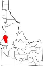
Adams County, Idaho Basics:


Adams County Idaho - Government Site

Population: 3,914
Area: 1363 square miles
County seat: Council
Area code(s) in use: 208
Time zone: MST
High school graduate or higher: 89.5%
Bachelor's degree or higher: 19.4%
Median household income: $35,756
Persons in poverty: 13.8%
Home ownership rate: 80.4%
Mean travel time to work: 18.9 minutes


Adjacent counties:
Baker (OR)  Gem  Idaho  Valley  Wallowa (OR)  Washington  
Find in Idaho

Map of the Adams County area


Our detail map of Adams County shows the Adams County, Idaho boundary lines and other interesting items.

Places in Adams County, Idaho

  Airports     show all on map

Council Municipal Airport, Flying Y Ranch Airport, Happy Hollow Ranch Airport, New Meadows Airport, Seven Devils Airport, Seven Devils Ranch Landing Strip

  Bars     show all on map

Big Bar, Eagle Bar

  Basins     show all on map

Ant Basin, Arbuckle Basin, Bear Basin, Bear Wallow, Burnt Wagon Basin, Cougar Basin, Ferguson Basin, Granite Basin, Horse Pasture Basin, Hubbard Basin, Lake Basin, Lost Basin, Lost Basin, Placer Basin, Round Valley, Six Lake Basin

  Beaches     show all on map

Red Ledge

  Bends     show all on map

The Oxbow

  Buildings     show all on map

Adams County Sheriff's Office, Council Police Department, Council Volunteer Fire District, Indian Valley Rural Fire Department, Indian Valley Rural Fire Department Station 2, Indian Valley Rural Fire Department Station 3, Meadows Valley Fire District, Salmon River Rural Fire District Station 1

  Canals     show all on map

East Fork Ditch, South End Ditch, Yantis Ditch

  Cemeteries     show all on map

Independent Order of Oddfellows Cemetery, Indian Valley Cemetery, Kessler Cemetery, Meadows Valley Cemetery, Winkler Cemetery

  Cliffs     show all on map

Black Point, Kinney Point, Lockwood Point, Red Point, The Dike, White Licks

  Dams     show all on map

Brundage Dam, C Ben Ross Dam, Copper Cliffs Tailings Dam, Glenn Gallant Dam, Goose Lake Dam, Hancock Dam, Hells Canyon Dam, Lost Valley Dam, Oxbow Dam, Oxbow Dam, Silver King Mines Number One Dam, Twin Granite Dam

  Falls     show all on map

Bear Creek Falls, Lost Creek Falls, Wildhorse Falls

  Flats     show all on map

Barber Flat, Bedrock Flat, Big Creek Meadows, Chokecherry Flat, Ecks Flat, Greasewood Flat, Hartly Meadows, Horse Flat, Lava Flat, Moorehead Flat, Paradise Flat, Paradise Flat, Rock Flat, Rocky Comfort Flat, Shingle Flat, Squaw Flat, The Flatiron

  Gaps     show all on map

Bear Saddle, Bell Saddle, Cold Spring Summit, Cold Springs Saddle, Cutoff Saddle, Holbrook Saddle, Joes Gap, Lockwood Saddle, Lynes Saddle, Mica Saddle, Oxbow Saddle, Purgatory Saddle, Railroad Saddle, Stevens Saddle

  Hospitals     show all on map

Adams County Health Center

  Islands     show all on map

Eagle Island

  Lakes     show all on map

Black Lake, Crystal Lake, Emerald Lake, Lake Winifred, Leeks Pond, Ruth Lake, Satan Lake, Twin Lakes, Twin Lakes

  Locales     show all on map

Barrinaga Corrals, Bear Campground, Bear Guard Station, Black Lake Campground, Cabin Creek Campground, Campbells Cow Camp, Circle C Ranch, Cold Springs Campground, Corral Creek Guard Station, Cottonwood Corrals, Cottonwood School, Council Lookout, Council Ranger Station, Decorah (historical), Deseret Cabin, Evergreen Campground, Fall Creek Access Area, Granite Mountain Lookout, Grouse Campground, Hillsdale School, Hoover Station, Hornet Ranger Station, Huckleberry Campground, Indian Mountain Lookout Station, Iron Springs, Jackley Mountain Lookout, Lafferty Campground, Last Chance Campground, Lick Creek Lookout, Lynes Ranch, Mesa Siding, Microwave Siphon Station, Mill Creek Ranger Station, New Meadows District Ranger Office, Paradise Cabin, Payette Lake Ski Area, Payette Lakes Ski Area, Pollock Mountain Lookout, Price Valley Guard Station, Scott Corral, Shannon Corral, Sheep Rock Overlook, Slaughter Gulch Campground, Smoky Forest Camp, Star Creek Camp, Thorn Creek Fire Camp, Upper Dale School, White School

  Mines     show all on map

Alaska Mine, Black Leopard Discovery Mine, Bluejacket Mine, Copper Cliff Mine, IXL Mine, Mica Mine, North Hornet Mine, Red Ledge Mine, South Peacock Mine

  Parks     show all on map

Hells Canyon Park, Packer Johns Cabin State Park, Rapid National Wild River

  Populated Places     show all on map

Alpine, Bacon, Bear, Beer Bottle Crossing, Council, Cuprum, Devils Ladder, Evergreen, Fruitvale, Glendale, Goodrich, Helena, Hillsdale (historical), Hoover, Indian Valley, Landore, Meadows, Mesa, New Meadows, Pine Ridge, Pinehurst, Rankin Mill, Rubicon, Starkey, Stevens, Tamarack, Wildhorse, Woodland

  Post Offices     show all on map

Helena Post Office (historical), Landore Post Office (historical), Starkey Post Office (historical)

  Rapidss     show all on map

Kerrs Rapids, Kerrs Rapids, Wildhorse Rapids

  Reservoirs     show all on map

Ben Ross Reservoir, Brundage Reservoir, Fish Lake, Goose Lake, Hells Canyon Reservoir, Hells Canyon Reservoir, Lost Valley Reservoir

  Ridges     show all on map

Blue Bunch Ridge, Cold Spring Ridge, Fort Hall Ridge, Grassy Ridge, Haley Ridge, Hornet Ridge, Long Gulch Ridge, Mica Ridge, Pleasant Ridge, Summers Point, Tussel Ridge, White Monument, Windy Ridge

  Schools     show all on map

Council Elementary School, Council Junior - Senior High School, McCall Seventh-Day Adventist Christian School, Meadows Valley Elementary School, Meadows Valley Junior-Senior High School, Ridge School (historical)

  Springs     show all on map

Aspen Spring, Big Tamarack Spring, Blue Bunch Spring, Casey Spring, Chipmunk Spring, Clifton Spring, Cold Spring, Cold Springs, Dean Spring, Dutch Oven Spring, Fir Point Spring, Fourbit Spring, Grouse Spring, Harrington Spring, Homestead Spring, Horse Spring, Hot Springs, Hot Springs, Indian Springs, Lamont Spring, Last Chance Spring, Little Bear Spring, Miller Spring, Oxbow Spring, Peck Mountain Spring, Shellworth Spring, Smoky Spring, Starkey Hot Springs, Stockade Spring, Strawberry Spring, Telephone Spring, Towsley Spring, Trail Creek Spring, Warm Spring, Weasel Spring, Willow Spring

  Streams     show all on map

Alder Creek, Allison Creek, Anchor Creek, Anderson Creek, Ant Basin Creek, Bacon Creek, Bear Creek, Beaver Creek, Bench Creek, Big Creek, Big Creek, Bisbee Creek, Blue Creek, Boulder Creek, Boulder Creek, Brown Creek, Brundage Creek, Brush Creek, Bull Corral Creek, Bull Horn Creek, Butte Creek, Cabin Creek, Camp Creek, Camp Creek, Camp Creek, Castle Creek, Cold Spring Creek, Cold Spring Creek, Cold Springs Creek, Copper Creek, Copper Creek, Corral Creek, Corral Creek, Cottonwood Creek, Cougar Creek, Cow Creek, Cow Creek, Crooked River, Crystal Creek, Deep Creek, Deer Creek, Deer Creek, Deer Licks Creek, Degits Creek, Dentene Creek, Derrick Creek, Dewey Creek, Dick Ross Creek, Ditch Creek, Doe Creek, Dog Creek, Dry Beaver Creek, Dry Creek, Dry Creek, East Branch Goose Creek, East Branch Weiser River, East Fork Lost Creek, East Fork Weiser River, Echols Creek, Eckels Creek, Elk Creek, Emery Creek, Fall Creek, Fawn Creek, Filly Creek, Finn Creek, Fir Creek, Fish Creek, Flat Creek, Four Bit Creek, Fourmile Creek, Fourth of July Creek, Fry Pan Creek, Garnet Creek, Gaylord Creek, Goodrich Creek, Goose Creek, Granger Creek, Granite Creek, Granite Fork, Grays Creek, Grizzly Creek, Grizzly Creek, Grouse Creek, Grouse Creek, Hall Creek, Hanson Creek, Heady Creek, Hell Creek, Hillman Creek, Huckleberry Creek, Indian Creek, Jackson Creek, Jacobs Ladder Creek, Johnson Creek, June Creek, Jungle Creek, Kinney Creek, Ladder Creek, Lake Creek, Lake Creek, Lake Fork, Lakey Creek, Left Fork North Hornet Creek, Lick Creek, Limepoint Creek, Little Bear Creek, Little Creek, Little Creek, Little Dry Gulch, Little Fall Creek, Little Goose Creek, Little Johnson Creek, Little Mud Creek, Little Weiser River, Lockwood Creek, Lockwood Creek, Lonesome Creek, Lost Creek, Lost Fork Creek, Louise Creek, Louse Creek, Mann Creek, Martin Creek, Mickey Creek, Middle Mud Creek, Mill Creek, Mill Creek, Mill Creek, Mill Creek, Mill Creek, Moonshine Creek, Mosquito Creek, Mud Creek, Murphy Creek, Myra Tree Creek, North Fork Cottonwood Creek, North Fork Grays Creek, North Fork Mill Creek, North Fork Star Creek, North Hornet Creek, North Star Creek, Oxbow Creek, Paradise Creek, Pearl Creek, Pin Creek, Placer Creek, Pole Creek, Pollock Creek, Pony Creek, Railroad Creek, Ritchie Gulch, Road Creek, Rock Creek, Rock Creek, Rose Creek, Rough Creek, Round Valley Creek, Salt Creek, Sawpit Creek, School Creek, Scorpion Creek, Seawell Creek, Sheep Creek, Sheep Creek, Sheep Creek, Shingle Creek, Sinking Creek, Sixmile Creek, Skern Creek, Skunk Cabbage Flat, Slim Creek, Sonner Creek, South Fork Grays Creek, South Fork Mill Creek, Spring Creek, Spring Creek, Squirrel Creek, Star Creek, Steen Creek, Steves Creek, Sucker Creek, Summer Creek, Summit Creek, Surprise Creek, Tarantula Creek, Telephone Creek, Thorn Creek, Thorn Creek, Thorn Creek, Threemile Creek, Thrush Creek, Trail Creek, Trail Creek, Trail Creek, Trail Creek, Trail Creek, Trestle Creek, Twin Fork Creek, Twin Lakes Creek, Vick Creek, Warm Spring Creek, Warm Springs, Wesley Creek, West Branch Goose Creek, West Branch Weiser River, West Fork Weiser River, West Mill Creek, Wickiup Creek, Williams Creek, Williamson Creek, Wolf Creek, Woodland Creek

  Summits     show all on map

Ant Butte, Black Imp, Brundage Mountain, Brush Mountain, Carbonate Hill, Casey Mountain, Cliff Mountain, Crooked River Point, Curren Mountain, Echols Mountain, Emmett Mountain, Fort Hall Hill, Granite Mountain, Horse Mountain, Indian Hill, Indian Mountain, Indian Mountain, Jackley Mountain, King Hill, Little Sheep Peak, Lone Tree, Meadow Hill, Meadows Summit, Mica Hill, Middle Mountain, Monument Peak, No Business Mountain, North Star Butte, Peck Mountain, Pepperbox Hill, Poison Timber Point, Pollock Mountain, Potato Knob, Pyramid Peak, Sheep Peak, Sheep Rock, Slab Butte, Smith Mountain, Stony Point, Sugarloaf, Trail Hill, Twin Sisters, White Mountain

  Swamps     show all on map

Frog Pond

  Towers     show all on map

KMCL-FM (Mccall)

  Trails     show all on map

Anderson Creek Trail, Arling Trail, Cabin Creek Trail, Cottonwood Basin Trail, Cougar Basin Trail, Deep Creek Trail, Donnelly Trail, Evans Trail, Granite Creek Trail, Grouse Creek Trail, Jungle Creek Trail, Little Weiser Trail, Mill Creek Trail, Rapid River Trail, Red Ledge Trail, Sheep Creek Trail, Sheep Rock National Recreation Trail, Sheep Trail

  Valleys     show all on map

Alder Gulch, Anderson Gulch, Badger Gulch, Bear Gulch, Bessie Gulch, Blue Jay Gulch, Bull Gulch, Bull Gulch, Bull Gulch, Butter Gulch, Butterfield Gulch, Calf Pen Gulch, Carson Gulch, Cold Spring Gulch, Cows Horn Gulch, Coyote Gulch, Devils Hollow, Dry Gulch, Dutch Oven Gulch, Fire Gulch, First Gulch, Fourth Gulch, Gladheart Gulch, Gore Gulch, Hardrock Gulch, Hathaway Gulch, Hibble Gulch, Hitchcock Gulch, Hoo Hoo Gulch, Huntley Gulch, Indian Valley, Larkspur Gulch, Limestone Gulch, Log Cabin Gulch, Long Gulch, Long Gulch, Long Gulch, Meadows Valley, Meridian Gulch, Monday Gulch, Negro Bill Gulch, Negro Jim Gulch, No Business Canyon, North Fork Fourth Gulch, Orchid Canyon, Pactolian Gulch, Price Valley, Red Gulch, Robison Gulch, Rocky Gulch, Ross Gulch, Schoolmam Gulch, Second Gulch, Slaughterhouse Gulch, Sucker Gulch, Summit Gulch, Tamarack Gulch, Telephone Draw, Third Gulch, Tiff Lindsay Draw, Timber Gulch, Traction Gulch, Warm Spring Gulch, Weasel Gulch,

Adams County, Idaho Population By Race (2012 estimate)

RacePopulation
WhiteAdams County White population 3,7853,784  
MixedAdams County Mixed population 6362
American IndianAdams County American Indian population 4343
AsianAdams County Asian population 2019
BlackAdams County Black population 87
Hawaiian & Pacific IslanderAdams County Hawaiian & Pacific Islander population 43

Additional population tables :
State population table
Idaho population by county