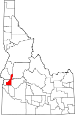
Gem County, Idaho Basics:


Gem County Idaho - Government Site

Population: 16,698
Area: 561 square miles
County seat: Emmett
Area code(s) in use: 208
Time zone: MST
High school graduate or higher: 84.4%
Bachelor's degree or higher: 14.2%
Median household income: $41,976
Persons in poverty: 17.8%
Home ownership rate: 74.5%
Mean travel time to work: 30.0 minutes


Adjacent counties:
Ada  Adams  Boise  Canyon  Payette  Valley  Washington  
Find in Idaho

Map of the Gem County area


Our detail map of Gem County shows the Gem County, Idaho boundary lines and other interesting items.

Places in Gem County, Idaho

  Airports     show all on map

Emmett Municipal Airport, Lanham Field

  Basins     show all on map

Antelope Swale, Coonrod Basin, Montour Valley, Sage Hen Basin

  Benches     show all on map

Emmett Bench

  Bends     show all on map

Regan Bend

  Bridges     show all on map

Letha Bridge

  Buildings     show all on map

Emmett Fire Department, Emmett Police Department, Gem County Ambulance Service, Gem County Fire District 1 Station 1, Gem County Fire District 1 Station 2, Gem County Fire District 2 Ola Station, Gem County Fire District 2 Sweet Station, Gem County Sheriff's Office

  Canals     show all on map

Black Canyon Canal, C-Line Canal, C-Line Canal West, Cash Nichols Ditch, Emmett Irrigation District North Side Main Canal, Farmers Cooperative Wasteway, Gem County Drainage, Kesgaard Ditch, Last Chance Canal, Maxfield Ditch, Patton Riggs Ditch, Rasmussen Ditch, Reed Canal, Roseberry Ditch, Seitz Ditch, Steward Ditch, Thornock Ditch

  Cemeteries     show all on map

Emmett Cemetery, Sweet Cemetery

  Cliffs     show all on map

Crown Point

  Dams     show all on map

Black Canyon Dam, Gatfield Number Two Dam, Haw Creek Dam, Little Dam, Sage Hen Dam

  Flats     show all on map

Big Flat, Greenfield Flat, Rammage Meadows, Tamarack Flat, Wilson Meadows

  Gaps     show all on map

Dodson Pass, Little Freezeout

  Hospitals     show all on map

Walter Knox Memorial Hospital

  Islands     show all on map

Fuller Island, Ross Island

  Lakes     show all on map

Beech Lake, Gabes Bathtub

  Locales     show all on map

Airport Pond Public Fishing Area, Antelope Campground, Butte Ranch, Cooper School, Eastside Campground, Emmett Plaza, Hollywood Point Campground, Indian Jakes, Picket Corral (historical), Plaza Road Bridge Access Area, Sage Hen Campground, Sage Hen Dam Recreation Site, Star Lane Pond Public Fishing Area, Third Fork Guard Station, Third Fork Project Camp, Van Duesan Ranch, Walker Mill (historical)

  Mines     show all on map

Aspen Mine, Gem State Mine, Liberty Mine, Lincoln Mine, Middleman Mine, Monroe Mine, X L Mine

  Populated Places     show all on map

Aikman (historical), Black Canyon, Bramwell, Cold House, Del Monte, Emmett, Gross, Jenness, Letha, Little Rock, Marsh (historical), Montour, Ola, Pearl, Plaza, Sweet

  Ranges     show all on map

West Mountains

  Reserves     show all on map

Payette River Wildlife Management Area, Star Lane Wildlife Habitat Area

  Reservoirs     show all on map

Black Canyon Reservoir, Sage Hen Reservoir

  Ridges     show all on map

Four Bit Spur, Third Fork Ridge

  Schools     show all on map

Brick Elementary School, Butte View Elementary School, Central Mesa School, Emmett Middle School, Emmett Senior High School, Hanna Intermediate School, Hanna School, Letha Primary School, Lincoln School, Ola Elementary - Junior High School, South Slope School, Sweet - Montour Elementary - Junior High School, Vanderdasson School

  Springs     show all on map

Box Spring, Lower Corral Creek Spring, Roystone Hot Springs, Sprout Spring, Tree Spring

  Streams     show all on map

Alkali Creek, Anderson Creek, Antelope Creek, Bent Creek, Big Cottonwood Creek, Bissel Creek, Bristol Creek, Brush Creek, Church Creek, Cold Spring Creek, Coon Creek, Corral Creek, Cottonwood Creek, Cottonwood Creek, Fourmile Creek, Fourmile Creek, Gold Run Creek, Havord Creek, Haw Creek, Jackson Creek, Jakes Creek, Joes Creek, Johnson Creek, Kennedy Creek, Kimball Creek, Little Cottonwood Creek, Little Squaw Creek, Long Hollow Creek, Long Pine Creek, Mesa Creek, Monger Creek, Muir Creek, North Fork Willow Creek, Pine Creek, Poison Creek, Pole Creek, Rattlesnake Creek, Renwyck Creek, Rock Creek, Rock Creek, Sand Hollow Creek, Schiller Creek, Second Fork Squaw Creek, Sevenmile Slough, Shirts Creek, Sixmile Creek, Soldier Creek, South Fork Willow Creek, Spring Creek, Squaw Creek, Sucker Creek, Sucker Creek, Third Fork Squaw Creek, Timber Creek, Timber Flat Creek, Webb Creek, Whitlock Gulch Creek, Woody Creek, Yergenson Creek

  Summits     show all on map

Buck Mountain, Four Bit Summit, Freezeout Hill, Friday Butte, Gabes Peak, Joes Butte, Little Butte, Mill Creek Summit, Ola Summit, Prospect Peak, Regan Butte, Squaw Butte, Tree Spring Mountain, Wilson Peak

  Towers     show all on map

KJHY-FM (Emmett)

  Trails     show all on map

Antelope Trail, Buck Canyon Trail, Division D Stock Trail, Gabes Peak Trail, Kimball Trail, Pine Creek Meadow Trail, Recompense Trail, Renwyck Trail, Shirts Creek Trail, West Mountain Trail, Wilson Corrals Trail, Wilson Mountain Trail, Woody Creek Trail

  Tunnels     show all on map

Tunnel Number 7 Wasteway

  Valleys     show all on map

Arkansas Canyon, Baltic Canyon, Bear Gulch, Blow Snake Gulch, Brush Canyon, Buck Canyon, Cherry Gulch, Cherry Gulch, Cold Spring Canyon, Coonrod Gulch, Currin Gulch, Deep Canyon, Dyes Gulch, Emmett Valley, Fir Gulch, Fir Gulch, Fir Tree Gulch, Kimball Gulch, Kingman Gulch, Lava Gulch, Little Arkansas Canyon, Minnis Canyon, Ola Valley, Peterson Gulch, Picket Corral Canyon, Salmon Gulch, Sand Hollow, Shake Gulch, Shellrock Canyon, Snyder Canyon, Spring Gulch, Stagecoach Canyon, Sulphur Gulch, Sweet Valley, Thron Gulch, Timber Gulch, Vaughan Gulch, Whitlock Gulch, Willmathe Gulch, Wood Canyon, Woodard Gulch,

Gem County, Idaho Population By Race (2012 estimate)

RacePopulation
WhiteGem County White population 15,99715,996  
MixedGem County Mixed population 367367
AsianGem County Asian population 150150
American IndianGem County American Indian population 134133
BlackGem County Black population 3333
Hawaiian & Pacific IslanderGem County Hawaiian & Pacific Islander population 1716

Additional population tables :
State population table
Idaho population by county