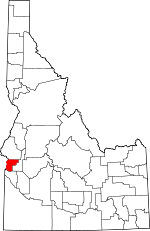
Payette County, Idaho Basics:


Payette County Idaho - Government Site

Population: 22,676
Area: 407 square miles
County seat: Payette
Area code(s) in use: 208
Time zone: MST
High school graduate or higher: 83.2%
Bachelor's degree or higher: 14.8%
Median household income: $42,747
Persons in poverty: 19.2%
Home ownership rate: 75.9%
Mean travel time to work: 19.2 minutes


Adjacent counties:
Canyon  Gem  Malheur (OR)  Washington  
Find in Idaho

Map of the Payette County area


Our detail map of Payette County shows the Payette County, Idaho boundary lines and other interesting items.

Places in Payette County, Idaho

  Airports     show all on map

Payette Municipal Airport

  Basins     show all on map

Bannister Basin

  Bends     show all on map

Whitley Bottom

  Bridges     show all on map

Falk Bridge

  Buildings     show all on map

Fruitland City Police Department, Fruitland Fire, New Plymouth Fire Department, New Plymouth Police Department, Orchard Ave Grange Hall, Payette City and Rural Fire Department, Payette County Paramedics, Payette County Sheriff's Office, Payette Police Department, SRV Coop Snap Building

  Canals     show all on map

A Line Canal, B Lateral, Bolton Canal, D-Line Canal, Farmers Cooperative Canal, Farmers Ditch, Graveyard Gulch Wasteway, H-Line Canal, Lower Payette Ditch, McIntyre Canal, Nelson Canal, Noble Canal, Patton Canal, Sand Hollow Wasteway, Washoe Ditch

  Cemeteries     show all on map

Falk Cemetery, Kennedy Cemetery, Parkview Cemetery, Riverside Cemetery, Washoe Cemetery

  Cliffs     show all on map

Clay Point, The Bluffs

  Dams     show all on map

Bettis Dam, Bettis Number Three Dam, Bettis Number Two Dam, Surmeier Dam

  Islands     show all on map

Banks Island, Birding Island, Crow Island, Gamble Island, Little Banks Island, Pool Island

  Locales     show all on map

Ammondo School, Blacks Bridge Access Area, Bluff Station Ferry, Falks, Vickery Access Area

  Parks     show all on map

Central Park, Kiwanis Park, Rosedale Memorial Park

  Populated Places     show all on map

Buckingham, Eiffie, Fort Wilson, French (historical), French Corner, Fruitland, Gayway Corner, Hamilton Corner, Ingard, New Plymouth, Palisades Corner, Payette, Payette Heights, Ramey, Sand Hollow, Washoe, Wood

  Reserves     show all on map

Little Banks Island Wildlife Habitat Area, Payette River Wildlife Management Area

  Reservoirs     show all on map

Bettis Reservoir

  Ridges     show all on map

Sheep Ridge

  Schools     show all on map

Eastside Primary School, Fruitland Elementary School, Fruitland High School, Fruitland Middle School, McCain Middle School, New Plymouth Elementary School, New Plymouth High School, New Plymouth Middle School, Payette Christian Academy, Payette High School, Payette Primary School, Treasure Valley Seventh-Day Adventist School, Westside Elementary School

  Springs     show all on map

Bradford Spring, Overstreet Spring, Raymer Spring, Sheep Spring

  Streams     show all on map

Alkali Creek, Big Willow Creek, Dry Creek, Forty-nine Slough, Hog Cove Creek, Indian Creek, Little Willow Creek, North Fork Alkali Creek, Payette River, Rattlesnake Creek

  Summits     show all on map

Hog Cove Butte

  Towers     show all on map

KIOV-AM (Payette), KQXR-FM (Payette)

  Valleys     show all on map

Alley Gulch, Ashlock Gulch, Big Whitley Gulch, Clair Rose Gulch, Dry Gulch, Graveyard Gulch, Heart Gulch, Holland Gulch, Homestead Gulch, Hurd Gulch, Langley Gulch, Little Whitley Gulch, Lower Payette Valley, McIntyre Gulch, Ringer Gulch, Road Gulch, Rock Quarry Gulch, Sand Hollow, Sand Hollow, Sheep Gulch, Stone Quarry Gulch, Tucker Canyon, West Gulch, Wet Gulch,

Payette County, Idaho Population By Race (2012 estimate)

RacePopulation
WhitePayette County White population 21,45121,451  
MixedPayette County Mixed population 567566
American IndianPayette County American Indian population 340340
AsianPayette County Asian population 204204
BlackPayette County Black population 9190
Hawaiian & Pacific IslanderPayette County Hawaiian & Pacific Islander population 2322

Additional population tables :
State population table
Idaho population by county