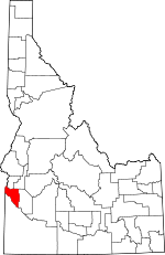
Canyon County, Idaho Basics:


Canyon County Idaho - Government Site

Population: 193,788
Area: 587 square miles
County seat: Caldwell
Area code(s) in use: 208
Time zone: MST
High school graduate or higher: 82.5%
Bachelor's degree or higher: 16.6%
Median household income: $42,691
Persons in poverty: 19.6%
Home ownership rate: 70.6%
Mean travel time to work: 23.7 minutes


Adjacent counties:
Ada  Gem  Malheur (OR)  Owyhee  Payette  
Find in Idaho

Map of the Canyon County area


Our detail map of Canyon County shows the Canyon County, Idaho boundary lines and other interesting items.

Places in Canyon County, Idaho

  Airports     show all on map

Caldwell Industrial Airport, Caldwell Municipal Airport, Davison Ranch Airport, Frank Field, Hubler Field, Jump West Parachute Center Airport, Mercy Heliport, Nampa Municipal Airport, Parma Airport, Symms Airport, Whelans Heliport

  Basins     show all on map

Hidden Valley

  Buildings     show all on map

Adelaide Theatre, Caldwell Fire and Rescue Station 1 Region 3 Hazmat Team, Caldwell Fire and Rescue Station 2, Caldwell Police Department, Canyon County Ambulance District 1, Canyon County Ambulance District 2, Canyon County Ambulance District 3, Canyon County Ambulance District 4, Canyon County Ambulance District 5, Canyon County Sheriff's Office, Carnegie Public Library (historical), Central Assembly Building, Chapman Hall (historical), Elmore Hall, Emerson Administration Building, Melba Rural Fire Protection District, Middleton Rural Fire District Station 1, Middleton Rural Fire District Station 2, Misericordia Hall, Nampa City Hall, Nampa Fire Department Station 1, Nampa Fire Department Station 2, Nampa Fire Department Station 3, Nampa Fire Department Station 4, Nampa Fire Department Station 5, Nampa Police Department, Parma Police Department, Parma Rural Fire District, Riley Library, Upper Deer Flat Fire Department, Wilder Police Department, Wilder Rural Fire Protection District

  Canals     show all on map

15.0 Lateral, 15.0 North Branch Lateral, 15.0 South Branch Lateral, 5.3 Lateral, 5.5 Lateral, 6.6 Lateral, 9.8 Lateral, A Drain, Aaron Drain, Alkali Drain, Allen Lateral, Amity Drain, Andrews Ditch, Arena Canal, Arena Case Drain, Arena Lake Drain, Attell Lateral, Aven Lateral, Bardsly Gulch Drain, Barth Lateral, Beal Lateral, Bennett Lateral, Benson Drain, Bernard Wasteway, Bohlson Lateral, Bolton Lateral, Boone Ditch, Brooks Lateral, Burke Lateral, Burris Lateral, Butte Lateral, C-Line Canal East, Caldwell Canal Feeder, Caldwell Drain, Caldwell High Line Canal, Caldwell Low Line Canal, Call Lateral, Canyon Canal, Canyon Hill Lateral, Carlson Lateral, Central Alkali Drain, Chance Lateral, Coe Lateral, Conroy Lateral, Coulee Drain, Crim Sublateral Lateral, Dailey Lateral, Deer Flat Caldwell Canal, Deer Flat High Line Canal, Deer Flat Low Line Canal, Deer Flat Nampa Canal, Deer Flat North Canal, Demke Lateral, Dewey Lateral, Dickens Drain, Dixie Drain, Dolbow Lateral, Dotson Drain, Drew Drain, Drew Lateral, Duval Lateral, East Alkali Drain, East Madden Lateral, East Railroad Lateral, Edwards Lateral, Elijah Drain, Escott Drain, Eureka Canal, Fargo High Line Canal, Fargo Low Line Canal, Fargo Wasteway, Farmers Cooperative Sebree Canal, Farmers Cooperative Sebree Canal Extension, Fenton Lateral, Fieselmann Lateral, Fisher Lateral, Fisk Sublateral, Flume Lateral, Fogarty Lateral, Forest Canal, Fowler Lateral, Frohman Wasteway, Front Ditch, Fuger Lateral, Garland Drain, Gebert Drain, Golden Gate Canal, Grade Ditch, Graham Lateral, Greenleaf Drain, Grimes Drain, Grouch Drain, Groves Branch Lateral, Gulch Lateral, Hat Butte Lateral, Heine Sublateral, Hellyer Drain, Herron Lateral, Highline Canal Feeder, Hill Canal, Holcomb Drain, Horton Lateral, Huff Lateral, Idaho Lateral, Isaiah Drain, Isham Drain, Jinx Lateral, Johnson Lateral, Kilbaine Lateral, Knob Sublateral, Lamm Drain, Langdon Lateral, Lizar Lateral, Lizard Wasteway, Lower Bartlett Lateral, Lower Center Point Canal, Lower Embankment Drain, Lower Fivemile Drain, Lucy Lee Lateral, Maddens Spur Drain, Martin Lateral, McIntyre Lateral, Melba Drain, Messler Lateral, Middle Lateral, Middleton Canal, Middleton Mill Ditch, Midway Lateral, Miller Lateral, Mitchel Drain, Mora Canal Extension, Moses Drain, Mumford Lateral, Mutch Lateral, Myers Drain, Needham Lateral, Newman Lateral, Nicholson Ditch, Noble Drain, Norris Lateral, North Alkali Drain, North Drain, North Drain, North McElroy Lateral, North Middleton Drain, North Nampa Lateral, North Power Lateral, North Robinson Lateral, North Valley Mound Wasteway, Notus Canal, Olson Drain, Olson Lateral, Paine Lateral, Parker Gulch Drain, Parma Canal, Partridge Lateral, Pass Lateral, Penninger Drain, Peters Lateral, Phipps Lateral, Phyllis Canal, Pickup Drain, Plowhead Lateral, Purdam Gulch Drain, Rhoads Lateral, Ridenbaugh Canal, Ridenbaugh High Line Canal, Riverside Canal, Rivett Lateral, Rock Spur Drain, Roedel Ditch, Ross Drain, Ross East End Drain, Ross Lateral, Ruby Drain, Safford Sublateral, Scholtie Lateral, Schott Lateral, Scott Drain, Seidenberd Canal, Selby Lateral, Sheckard Lateral, Shelp Gulch Drain, Sleepy Hollow Drain, Solomon Drain, South Boise Drain, South Drain, South McElroy Lateral, South Middleton Drain, South Nampa Lateral, Stewart Lateral, Stone Lateral, Sturgeon Lateral, Summitt Lateral, Sunnyslope Lateral, Super Lateral, Thacker Lateral, Thacker Lateral, Three Buttes Drain, Tinker Lateral, Upper Center Point Canal, Vantress Lateral, Vasold Lateral, Waldvogel Canal Wasteway, Walters Butte Lateral, Watkins Ditch, Watson Lateral, Watts Lateral, Weeks Drain, West Canyon Canal, West End Drain, West Fork Golden Gulch Drain, West Lateral, West Madden Lateral, Weymouth Lateral, Whizzer Lateral, Willard Lateral, Willow Creek Pump Lateral, Wilson Drain, Wood Drain, Wordica Lateral, Yarnell Lateral

  Capes     show all on map

Gotts Point

  Cemeteries     show all on map

Canyon Hill Cemetery, Fargo Cemetery, Hillcrest Memorial Gardens, Lower Boise Cemetery, Mount Calvary Cemetery, Parma Cemetery, Pleasant Ridge Cemetery, Roswell Cemetery, Wilder Cemetery

  Churches     show all on map

Assembly of God Church, Calvary Baptist Church, Church of God, Church of the Brethren, College Church of the Nazarene, First Baptist Church, First Christian Church, First Church of Christ Scientist, First Church of the Nazarene, First Methodist Church, Foursquare Church, Grace Episcopal Church, Iglesia Del Nazareno, Kingdom Hall of Jehovahs Witnesses (historical), Lakeview Church of the Nazarene, Nampa Friends Church, Saint Paul's Roman Catholic Church, Seventh Day Adventist Church, Trinity Lutheran Church (historical), United Presbyterian Church, Wesleyan Holiness Church (historical)

  Cliffs     show all on map

Gravelly Point

  Dams     show all on map

Deer Flat-Lower Dam, Deer Flat-Middle Dam, Deer Flat-Upper Dam, Golden Gate Drop

  Flats     show all on map

Deer Flat, Lower Deer Flat, Upper Deer Flat, Upper Deer Flat

  Hospitals     show all on map

Mercy Hospital (historical), Saint Alphonsus Medical Center - Nampa, Samaritan General Hospital (historical), West Valley Medical Center

  Islands     show all on map

Big Cottonwood Island, Big Rocky Island, Billy Goat Island, Blackburn Island, Blind Island, Bridge Island, Brooks Island, Clarks Island, Current Island, Dilley Island, Dredge Island, Fischer Island, Foglers Island, Fruit Island, Goat Island, Gold Island, Goldeneye Island, Goose Egg Island, Guffey Island, Gull Island, Heron Island, Little Rocky Island, McConnel Island, Noble Island, Rabbit Island, Raccoon Island, Rail Island, Richards Island, Settlers Island, Sign Island, Smiths Island, Ware Island

  Lakes     show all on map

Jensen Lake, Pintail Pond, Ralphs Pond, Redhead Pond, Swan Pond, Wood Duck Pond

  Locales     show all on map

Bernard Ferry, Bowman Ranch, Caldwell Labor Camp, Caldwell Ponds Public Fishing Area, Deer Flat National Wildlife Headquarters, Demke Pipeline, Dixie Access Area, Duff Lane Pond Public Fishing Area, Forest Pipeline, Fort Boise (historical), Franklin Labor Camp, Holly Shopping Center, Karcher Mall, Melmont, Mud Lake Cow Camp, Nampa Hatchery, Nampa Shopping Center, Pleasant Ridge Grange, Sage Acres Race Track, Shoppers Plaza, Stoddard, Sugar Factory Camp, Takatori Access Area, Univ of Idaho Agr Experimental Station

  Parks     show all on map

Celebration County Park, Deer Flat National Wildlife Refuge, Kurtz Park, Lakeview Park, Ward Memorial State Park

  Pillars     show all on map

Map Rock

  Populated Places     show all on map

Allendale, Amsco, Apple Valley, Bowmont, Bugtown (historical), Caldwell, Central Cove, Deal, Doles, Enrose, Fischer, Fort Boise (historical), Greenleaf, Huston, Josephson, Karcher Junction, Kings Corner, Knowlton Heights, Maddens, Melba, Middleton, Midway, Moss, Nampa, Notus, Parma, Riverside, Rookstool Corner, Roswell, Simplot, Sunnyslope, Swartz Corner, Tiegs Corner, Underkoflers Corner, Walters Ferry, Warrens, Weitz, Westma, Wilder

  Post Offices     show all on map

Nampa Post Office

  Ranges     show all on map

Chalk Hills

  Reserves     show all on map

Fort Boise Wildlife Management Area, Rowell Marsh Wildlife Habitat Area, Sand Hollow Wildlife Habitat Area

  Reservoirs     show all on map

Lake Lowell

  Schools     show all on map

Albertson College of Idaho, Apple Valley School, Boulevard Christian School, Caldwell Senior High School, Canyon School, Centennial Elementary School, Center Point School, Central Canyon Elementary School, Central Elementary School, Central Park School, East Elementary School, East Side Elementary School, Enrose School, Four-H Adventure Club, Franklin School, Gem State Academy, Greengurst School, Greenhurst Elementary School, Greenleaf Friends Academy, Greenleaf School, Happy Valley School, Holmes Elementary School, Huston School, Jefferson Junior High School, Kenwood School, Lake Lowell School, Lakeview Elementary School, Lakeview School, Lincoln Elementary School, Lincoln Elementary School, Lone Star School, Lone Tree School, Maple Grove School, Marble Front School, Maxine Johnson Elementary School, Melba Elementary School, Melba Junior-Senior High School, Middleton Heights Elementary School, Middleton High School, Middleton Middle School, Middleton Primary School, Midway School, Nampa Alternative High School, Nampa Christian Schools, Nampa Senior High School, Nampa State School, New Horizon School, Northwest Nazarene University, Notus Elementary - Junior High School, Notus High School, Parkview Primary School, Parma High School, Parma Middle School, Pleasant Ridge School, Red Top School, Roosevelt Elementary School, Sacajawea Elementary School, Saint Pauls School, Scism School, Seventh-Day Adventist Elementary School, South Junior High School, South Side Blvd School, Sunny Ridge Elementary School, Univ of Idaho Agriculture Experiment Station, Vallivue High School, Vallivue Junior High School, Van Buren Elementary School, Washington Elementary School, West Elementary School, West Junior High School, Wilder Head Start, Wilder Junior-Senior High School, Wiley Learning Center, Woodrow Wilson Middle School, Zion Lutheran School

  Springs     show all on map

Sproat Spring

  Streams     show all on map

12th Ave Drain, Allen Drain, Boise River, Dixie Slough, Fifteenmile Creek, Fivemile Creek, Imbler Drain, Johanson Drain, Jonah Drain, Mason Slough, Mill Slough, Parma Drain, Perkins Drain, Phyllis Slough, Rachel Drain, Sand Hollow Creek, Tenmile Creek, Upper Embankment Drain, Warm Springs Creek, Willow Creek

  Summits     show all on map

Hat Butte, Liberty Butte, Lizard Butte, Madden Butte, McElroy Butte, McIntyre Hill, Pickle Butte, Pickles Butte, Powers Butte, Walters Butte, White Butte

  Towers     show all on map

KBGN-AM (Caldwell), KCID-AM (Caldwell), KCID-FM (Caldwell), KIDH-AM (Eagle), KKIC-AM (Boise)

  Valleys     show all on map

Arena Valley, Benson Gulch, Christian Gulch, Conway Gulch, Deadhorse Canyon, Dixie Gulch, East Hartley Gulch, Guess Gulch, Lanktree Gulch, Mammen Gulch, Pipe Gulch, Sand Run Gulch, West Hartley Gulch

  Wells     show all on map

Steelman Well, Street Well,

Canyon County, Idaho Population By Race (2012 estimate)

RacePopulation
WhiteCanyon County White population 182,161182,160  
MixedCanyon County Mixed population 4,6514,650
American IndianCanyon County American Indian population 3,1013,100
AsianCanyon County Asian population 1,9381,937
BlackCanyon County Black population 1,3571,356
Hawaiian & Pacific IslanderCanyon County Hawaiian & Pacific Islander population 581581

Additional population tables :
State population table
Idaho population by county