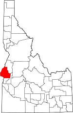
Washington County, Idaho Basics:


Washington County Idaho - Government Site

Population: 10,041
Area: 1453 square miles
County seat: Weiser
Area code(s) in use: 208
Time zone: MST
High school graduate or higher: 80.2%
Bachelor's degree or higher: 15.8%
Median household income: $36,311
Persons in poverty: 14.8%
Home ownership rate: 74.2%
Mean travel time to work: 22.0 minutes


Adjacent counties:
Adams  Baker (OR)  Gem  Malheur (OR)  Payette  
Find in Idaho

Map of the Washington County area


Our detail map of Washington County shows the Washington County, Idaho boundary lines and other interesting items.

Places in Washington County, Idaho

  Airports     show all on map

Jenkins Creek Ranch Airport, Lee Williams Memorial Airport, Weiser Municipal Airport

  Basins     show all on map

Grizzly Basin, Henley Basin, Stinking Water Basin, Weiser Cove

  Bends     show all on map

Farewell Bend

  Buildings     show all on map

Cambridge Fire Protection District, Midvale Fire District, Washington County Sheriff's Office, Weiser Area Rural Fire District Station 1, Weiser Area Rural Fire District Station 2, Weiser City Fire and Rescue, Weiser Police Station

  Canals     show all on map

Galloway Canal, Grimmet Lateral, Middle Valley Ditch, Nola Lateral, Smith-Hemenway Lateral, Sunnyside Canal

  Cemeteries     show all on map

Galloway Cemetery, Mann Creek Cemetery, Midvale Cemetery

  Cliffs     show all on map

Devils Slide, Rocky Point

  Dams     show all on map

Barton Dam, Bruce Dam, Courtright Dam, Craig Dam, Crane Creek Dam, Fairchild Dam, Galloway Dam, Hornet Creek-Lower Dam, Hornet Creek-Upper Dam, Jenkins Creek Dam, Land Dam, Little Crane Creek Dam, Little Dam, Mann Creek Dam, Monroe Dam, Paddock Valley Dam, Scott Creek Dam, Swain Number One Dam, Swain Number Two Dam

  Falls     show all on map

Rush Falls

  Flats     show all on map

Big Flat, Calamity Meadows, Coffee Flat, Little Willow Flat, Nutmeg Flat, Olive Meadows, Pine Grass Flat, Tamarack Flat, West Weiser Flat

  Gaps     show all on map

Bear Saddle, Benton Saddle, Devils Elbow, Low Pass, Telephone Saddle

  Hospitals     show all on map

Weiser Memorial Hospital

  Islands     show all on map

Long Island, McRea Island, Rock Island, Smith Island, Wildcat Island

  Lakes     show all on map

Buttermilk Slough, Rush Lake

  Locales     show all on map

Blakes Junction, Brownlee Ranger Station, Buck Park, Buck park Guard Station, Cable Ferry, Catrock School, Cove School, Cozy Corners School, Crawford Place, Crystal School, Deer Creek School, Eastside School, Echo Dell School, Enterprise School, Hit Mountain Ski Area, Hitt Mountain Ski Area, Johnson Creek Park, Justrite Campground, Kiawanis Campground, Lower Crystal School, Mann Creek Guard Station, Olds Ferry, Paradise Campground, Pleasant View School, Porters Ferry, Presley, Presley Station, Repeater Station, Roberts Access Area, Rock Island Station, Spring Creek Campground, Sturgil Peak Lookout

  Mines     show all on map

Cuddy Mine, Idaho Almaden Mine, Mortimer Mine

  Parks     show all on map

Mann Creek State Park

  Populated Places     show all on map

Barton, Cambridge, Concrete, Crane (historical), Crystal, Diamond, Eaton, Feltham, Heath, Heath (historical), Jonathan, Midvale, Mineral, Rebecca, Salubria, Weiser

  Post Offices     show all on map

Helena Post Office (historical)

  Ranges     show all on map

Cuddy Mountains, Hitt Mountains, Hitt Mountains

  Rapidss     show all on map

Sturgill Rapids

  Reservoirs     show all on map

Barton Reservoir, Brownlee Reservoir, Crane Creek Reservoir, Fairchild Reservoir, Groner Reservoir, Hornet Reservoir, Jenkins Creek Reservoir, Little Crane Creek Reservoir, Lower Hornet Reservoir, Mann Creek Reservoir, Paddock Valley Reservoir, Soulen Reservoir

  Ridges     show all on map

Dead Indian Ridge, Tennison Ridge, Willow Ridge, Willow Ridge

  Schools     show all on map

Cambridge Elementary School, Cambridge Junior-Senior High School, Central School, Eaton School, Haas School, Hale School, Jeffreys School, Midvale Alternative School, Midvale Elementary School, Midvale High School, Midvale Junior High School, Midvale School Danny Warfield Memorial Gymnasium, Midvale School Music Building, Midvale School Professional-Technical Building, Park Intermediate School, Pioneer Primary School, Sage Creek School, Sailing School, Saling School, South Crane School, Sunnyside School, Weiser High School, Weiser Junior High School, Westside School

  Springs     show all on map

Arrowhead Spring, Bill George Spring, Box Spring, Cherry Spring, Coffee Spring, Cottonwood Spring, Denton Spring, Devils Hole, Flag Spring, French Spring, Greenfield Spring, Lime Spring, Looney Spring, Moore Spring, Mossman Spring, Sandy Spring, Seep Spring, Toe Jam Spring, Tribe Spring, Weiser Warm Springs

  Streams     show all on map

Adams Creek, Banner Creek, Bear Creek, Bear Creek, Beaver Creek, Beaver Creek, Benton Creek, Blue Spring Creek, Brownlee Creek, Cabin Creek, Camp Creek, Camp Creek, Camp Creek, Cave Creek, Cottonwood Creek, Cove Creek, Cow Creek, Crane Creek, Deep Creek, Deer Creek, Deer Creek, Deer Creek, Dennett Creek, Dixie Creek, Dukes Creek, East Brownlee Creek, East Fork Keithly Creek, East Fork Sturgill Creek, East Pine Creek, Edna May Creek, Fir Creek, Flat Creek, Fourth of July Creek, Galena Creek, Grade Creek, Grizzly Creek, Grouse Creek, Grouse Creek, Henley Creek, Hitt Creek, Hog Creek, Hog Creek, Hog Creek, Jenkins Creek, Keithly Creek, Lick Creek, Linson Creek, Little Rock Creek, Mann Creek, Middle Brownlee Creek, Middle Creek, Middle Fork North Fork Dennett Creek, Middle Fork Sturgill Creek, Mill Creek, Monroe Creek, No Business Creek, North Creek, North Fork Dennett Creek, North Fork Grade Creek, Olive Creek, Perkins Creek, Pine Creek, Placer Creek, Pole Creek, Pole Creek, Porcupine Creek, Raft Creek, Robinson Creek, Rock Creek, Rock Creek, Rush Creek, Scott Creek, She Creek, Sheep Creek, Sheep Creek, Sheep Creek, Sheep Creek, Shirts Creek, South Crane Creek, South Pine Creek, Spring Creek, Spring Creek, Spring Creek, Spring Creek, Stacy Creek, Star Butte Creek, Starveout Creek, Sturgill Creek, Sumac Creek, Swamp Creek, Tamarack Creek, Tennison Creek, Thorn Spring Creek, Thousand Springs Creek, Trail Creek, Trail Creek, Warm Springs Creek, Wash Pan Creek, Wayle Creek, Weiser River, West Brownlee Creek, West Cherry Creek, West Pine Creek, Wildhorse River, Willy May Creek, Wolf Creek

  Summits     show all on map

Ant Butte, Bear Creek Summit, Bear Wallow Point, Benton Peak, Big Hill, Chinamans Hat, Corner Mountain, Cuddy Mountain, Granger Butte, Haystack, Hitt Peak, Hog Creek Butte, Indian Head Mountain, Iron Mountain, Kelly Mountain, McChord Butte, Midvale Hill, Monroe Butte, Pyramid Point, Riley Butte, Rush Peak, Sagebrush Hill, Star Butte, Sturgill Peak, Sugarloaf, Tool Cache, Wilburn Butte

  Towers     show all on map

KWEI-AM (Weiser), KWEI-FM (Weiser)

  Trails     show all on map

One Spoon Way (historical)

  Valleys     show all on map

Advent Gulch, Barton Gulch, Black Canyon, Board Gulch, Box Gulch, Cherry Gulch, Cherry Gulch, Coal Mine Gulch, Conner Gulch, Corral Gulch, Davis Canyon, Dead Man Gulch, Deadhorse Gulch, Deer Gulch, Deer Gulch, Fairchild Gulch, Garden Gulch, George Way Gulch, Golden Goose Canyon, Haystack Gulch, Jackson Gulch, Jeffrey Gulch, Limestone Gulch, Lone Pine Gulch, McCullough Gulch, Middle Valley, Mulmick Gulch, Neil Valley Gulch, Quartz Gulch, Rattlesnake Gulch, Reservoir Gulch, Road Gulch, Salubria Valley, Sand Hollow, Sawlog Glacier, Sheep Camp Glacier, Sheep Gulch, Shoe Peg Valley, Smith Gulch, Stickney Glacier, Surdam Gulch, Tartar Gulch, Toe Jam Canyon, Tribe Gulch, Two Tree Gulch,

Washington County, Idaho Population By Race (2012 estimate)

RacePopulation
WhiteWashington County White population 9,5599,559  
MixedWashington County Mixed population 181180
American IndianWashington County American Indian population 131130
AsianWashington County Asian population 120120
BlackWashington County Black population 4040
Hawaiian & Pacific IslanderWashington County Hawaiian & Pacific Islander population 1010

Additional population tables :
State population table
Idaho population by county