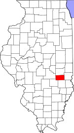
Cumberland County, Illinois Basics:
Cumberland County Illinois - Government Site
Population: 10,977
Area: 346 square miles
County seat: Toledo
Area code(s) in use: 217
Time zone: CST
High school graduate or higher: 89.1%
Bachelor's degree or higher: 12.3%
Median household income: $44,430
Persons in poverty: 13.4%
Home ownership rate: 82.7%
Mean travel time to work: 23.4 minutes
Adjacent counties:
Clark Coles Effingham Jasper Shelby
Places in Cumberland County, Illinois
Cumberland Air Park RLA Airport,
Thornton Airport,
Williamson Airport Sconce Bend Ryan Bridge Cumberland County Courthouse,
Greenup Area Ambulance Service,
Greenup Fire Department,
Greenup Township Carnegie Library,
Lincoln Trail Motosports Park,
Neoga Fire Protection District,
Spring Point Town Hall,
Sumpter Township Library,
Toledo Area Emergency Ambulance Service,
Toledo Volunteer Fire Department Allison Cemetery,
Bear Creek Cemetery,
Bell Cemetery,
Berry Cemetery,
Block Cemetery,
Boots Cemetery, Bright Cemetery,
Brush Creek Cemetery, Buchanan Cemetery, Carson Cemetery,
Chezem Cemetery,
Church of Christ Cemetery,
Church of God Cemetery,
Concord Cemetery, Cumberland County Poor Farm Cemetery, Curns Cemetery, Cutright Cemetery, Davison Cemetery,
Decker Cemetery, Downey Cemetery,
Drummond Cemetery,
Duck Pond Cemetery,
Elliott Cemetery,
Farmer Cemetery,
Faunce Cemetery, Feitner Cemetery, Feltner Cemetery, Fox Cemetery,
Friends Grove Cemetery,
Garrett Cemetery, Gaskell Cemetery, Gordon Graveyard,
Greenup Cemetery, Greeson Cemetery, Greeson Cemetery,
Haggins Cemetery, Haggins Cemetery,
Harmony Cemetery, Hill Cemetery,
Hutton Cemetery,
Illinois Central Pioneer Cemetery,
Illinois Central Railroad Cemetery,
Jack Oak Cemetery, Janesville Memorial Cemetery,
Jewett Cemetery,
Kingery Cemetery, Kirking Cemetery,
Liberty Hill Cemetery,
Lillyville Cemetery,
Lockhart Cemetery,
Long Point Cemetery,
Long Point Cemetery,
Macedonia Cemetery, McCormick Cemetery,
Mullen Cemetery,
Neal Cemetery,
Nebo Cemetery,
Needham Cemetery,
Neoga Cemetery,
Neoga Railroad Crossing Cemetery, Neoga Railroad Crossing Cemetery,
Paul Cemetery,
Peach Orchard Cemetery, Prentice Cemetery,
Ruffner Cemetery, Ryan Cemetery, Saint Patrick Cemetery,
Saint Rose Cemetery,
Salem Cemetery, Shamer Burial Cemetery, Sigel Cemetery, Spain Cemetery,
Tippett Cemetery,
Toledo Cemetery, Tomlinson Cemetery, Troxel Cemetery,
Union Cemetery,
Upper Berry Cemetery,
Washington Cemetery, Woodbury Cemetery,
Zion Cemetery Bradbury Free Methodist Church,
Brush Creek Church,
Calvary Tabernacle,
Concord Church (historical),
First Baptist Church,
First Christian Church of Neoga,
First Presbyterian Church,
Grace United Methodist Church,
Harmony Friends Church,
Jack Oak Church of God,
Jewett Community Church,
Liberty Hill United Methodist Church,
Long Point Church (historical),
Macedonia Baptist Church,
Morton Chapel (historical),
Mount Zion Baptist Church,
Mount Zion Church,
Mount Zion Church (historical),
Mullen Church,
Pleasant Valley Church (historical),
Roslyn United Methodist Church (historical),
Sacred Heart Church,
Salem Church,
Shiloh Church,
Washington Evangelical United Brethren Church (historical),
Whitehall Church (historical),
Zion Chapel United Brethren Church (historical) Bowman Ford,
Cherwood Ford,
Interchange 119,
Interchange 177,
McCann Ford,
Rocky Ford Ettlebrick Lake Dam,
Lake Louise Dam,
Montrose City Lake Dam Cumberland County Farm (historical) Greenup Commercial Historic District Bradbury,
Dees,
Greenup,
Hazel Dell,
Janesville,
Jewett,
Johnstown,
Liberty Hill,
Lillyville,
Maple Point,
Neal,
Neoga,
Roslyn,
Timothy,
Toledo,
Union Center,
Vevay Park,
Walla Walla,
Woodbury Fulkerson Post Office (historical),
Greenup Post Office,
Hazel Dell Post Office,
Janesville Post Office,
Jewett Post Office,
Mule Creek Post Office (historical),
Neoga Post Office,
Toledo Post Office Ettlebrick Lake,
Lake Louise,
Lake Mattoon,
Montrose City Lake,
Woodbury Lake Aleshire School (historical),
Apperson School (historical),
Baumgartner School (historical),
Bean School (historical),
Beehive School (historical),
Berry School (historical),
Brown School (historical),
Brushy Ridge School (historical),
Buck Branch School (historical),
Butterfly School (historical),
Center School (historical),
Center School (historical),
Christian Run School (historical),
Clear Creek School (historical),
Copeland School (historical),
Crossing School (historical),
Cumberland Elementary School,
Cumberland High School,
Delno School (historical),
Dewey School (historical),
East Whiteoak School (historical),
Fair Play School (historical),
Fairview School (historical),
Folly Grove School (historical),
Haddock School (historical),
Hamilton School (historical),
Hickory Corner School (historical),
Hickory School (historical),
Jack Oak School (historical),
Jones School (historical),
King School (historical),
Lacey School (historical),
Lambert School (historical),
Lefever School (historical),
Liberty Hill School (historical),
Lillyville Elementary School,
Little Brown School (historical),
Lockwain School (historical),
Lone Elm School (historical),
Long Point School (historical),
Lookout School (historical),
Lost Creek School (historical),
Maple Grove School (historical),
McMillan School (historical),
Mumford School (historical),
Neoga Elementary School,
Neoga Senior High School,
Oak Chapel School (historical),
Pleasant Grove School (historical),
Plum Grove School (historical),
Prairie School (historical),
Rader School (historical),
Reed School (historical),
Ruffner School (historical),
Scotch Chapel School (historical),
Shull School (historical),
Silver Lake School (historical),
Silver Leaf School (historical),
Spring Point School (historical),
Stitt School (historical),
Titus School (historical),
Union School (historical),
Wade School (historical),
Walk School (historical),
Washington School (historical),
Weatherholt School (historical),
Weaver School (historical),
Webster School (historical),
West Union School (historical),
West Union School (historical),
Whitehall School (historical),
Whiteoak School (historical),
Yanaway School (historical),
Zion School (historical) Bear Creek,
Bell Branch,
Birch Creek,
Bruce Creek,
Brush Creek,
Brush Creek,
Buck Branch,
Bush Creek,
Chivler Creek,
Clear Creek,
Clear Creek,
Clear Creek,
Cottonwood Creek,
Crooked Creek,
Darkies Creek,
Dicks Creek,
Fulfer Branch,
Hurricane Creek,
Long Point Creek,
Lost Creek,
McKnight Branch,
Miller Creek,
Muddy Creek,
Mule Creek,
Opossum Creek,
Otter Branch,
Range Creek,
Ruffner Creek,
Spring Point Creek,
Turkey Creek Buck Knoll,
Graveyard Hill Austin Hollow,
Gold Hollow,
Lick Hollow,
Tippett Hollow,

