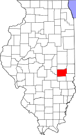
Coles County, Illinois Basics:
Coles County Illinois - Government Site
Population: 53,659
Area: 508 square miles
County seat: Charleston
Area code(s) in use: 217
Time zone: CST
High school graduate or higher: 89.2%
Bachelor's degree or higher: 24.1%
Median household income: $38,088
Persons in poverty: 22.0%
Home ownership rate: 62.4%
Mean travel time to work: 17.5 minutes
Adjacent counties:
Clark Cumberland Douglas Edgar Moultrie Shelby
Places in Coles County, Illinois
Coles County Memorial Airport,
John R Reed Airport,
Townley Farms Airport Goosenest Prairie Airtight Bridge Andrews Hall,
Ashmore Fire Protection District,
Booth House,
Brainard House,
Burgess-Osborne Auditorium,
Burl Ives Art Studio Hall,
Buzzard House,
Charles H Coleman Hall,
Charles P Lantz Health Physical Education and Recreation Building,
Charleston Fire Department Station 1,
Charleston Fire Department Station 2,
Charleston Public Library,
Coles County Courthouse,
Coles County Jail,
Cooks Mills Fire Protection District,
Florence McAfee Gymnasium,
Ford Hall,
Francis G Blair Hall,
Gregg Hall,
Humboldt Community Fire Protection District,
Hutton Fire Protection District,
Lawson Hall,
Lincoln Fire Protection District,
Lincoln Fire Protection District,
Lincoln-Stevenson-Douglas Halls,
Linder House,
Livingston C Lord Administration Building,
Lumpkin Hall,
Martin Luther King Junior University Union,
Mary J Booth Library,
Mattoon City Hall,
Mattoon Fire Department Station 1,
Mattoon Fire Department Station 2,
Mattoon Fire Department Station 3,
Mattoon Public Library,
McKinney Hall,
Memorial Library,
Oakland Community Fire Protection District,
Pemberton Hall,
Phipps Lecture Hall,
Quincy V Doudna Fine Arts Center,
Roberts G Buzzard Building,
Seven Hickory - Morgan Township Fire Protection District,
Tarble Arts Center,
Taylor Hall,
Thomas Hall,
Thut Greenhouse,
Virgil H Judge Learning Resource Center,
Wabash Fire Protection District,
Walter Klehm Hall,
Weller Hall Buttermilk Ditch,
Union Drainage District Number 3 Adkins Cemetery,
Anderson Cemetery, Andrew Lanman Farm Cemetery,
Armstrong Cemetery,
Ashmore Cemetery,
Bales Cemetery, Baptist Burial Ground,
Beals Cemetery,
Beavers Cemetery,
Bell Cemetery,
Berry Cemetery,
Bethel Cemetery, Bowles Cemetery,
Brandenburg Cemetery,
Brann Cemetery,
Brooks Cemetery,
Calvary Cemetery,
Campground Cemetery, Campground Cemetery, Cartwright Cemetery,
Chambers Cemetery, Charleston Town Branch Cemetery,
Coles County Poor Farm Cemetery, Collins Cemetery, Combs Cemetery, Concord Cemetery, Cooks Mill Cemetery,
Cossel Cemetery, Country Grave,
Craig Cemetery,
Dodge Grove Cemetery, Dodrich Cemetery,
Doty Cemetery, Drummade Cemetery,
Dry Grove Cemetery,
East Humboldt Cemetery, Ellington Cemetery, Embarrass Cemetery,
Enon Cemetery, Fairfield Cemetery,
Fairview Cemetery, Freeman Cemetery, French Cemetery,
Fudge Cemetery, Fuller Cemetery,
Gardner Cemetery, Gearhart Cemetery, Gibbs Cemetery, Golliday Cemetery, Gordon Cemetery,
Grant Cemetery, Green Hill Cemetery, Hitesville Cemetery,
Hoagland (historical),
Huckaba Cemetery,
Humboldt Cemetery,
Hurricane Cemetery, Independent Order of Odd Fellows Cemetery, Indiana Cemetery,
Janesville Cemetery,
Kelley Cemetery,
Kickapoo Cemetery,
Knoch Cemetery, Laffery Cemeterty,
Lafler Cemetery,
Leitch Cemetery,
Liberty Cemetery,
Lower Muddy Cemetery,
Lumbrick Cemetery, Maple Hill Cemetery,
McKenzie Cemetery,
Miller Cemetery, Mitchell Cemetery,
Montgomery Cemetery, Monticello Cemetery,
Mound Cemetery,
Mount Tabor Cemetery,
Mount Zion Cemetery, Muddy Point Cemetery, Murphysboro Cemetery, Nellie Ross Hyde Memorial Gardens,
New Indian Creek Cemetery,
New Kelley Cemetery, Oak Cemetery,
Oak Grove Cemetery,
Old Baptist Cemetery,
Old Charleston Cemetery, Old Cooks Mills Cemetery, Old Curtis Cemetery, Old Indian Cemetery,
Old Indian Creek Cemetery, Old Spies Cemetery, Olmstead Cemetery,
Oterlin Cemetery,
Parker Cemetery, Parker Cemetery, Parker Cemetery, Parker Cemetery,
Patsy Mitchell Cemetery,
Pleasant Grove Cemetery, Pleasant Prairie Cemetery, Reat Cemetery,
Reed Cemetery,
Rest Haven Memorial Gardens,
Rosedale Cemetery,
Roselawn Cemetery, Rutherford Cemetery,
Saint Omer Cemetery,
Salem Cemetery,
Salisbury Cemetery,
Sargent Cemetery,
Shields Cemetery,
Shiloh Cemetery,
Shoot Cemetery,
Smith Cemetery,
Stewart Cemetery,
Stoner Cemetery,
Stringtown Cemetery, Thomas Lincoin Cemetery,
Township Cemetery,
Union Cemetery,
Unity Cemetery,
Upper Muddy Cemetery, Vandaren Cemetery,
Welch Cemetery, Wells Cemetery,
Whetstone Cemetery, Whorl Cemetery,
Wiley Brick Cemetery, Willis Replogle Farm Cemetery,
Winkleblack Cemetery,
Wright Cemetery,
Yocum Cemetery,
Zimmerman Cemetery,
Zion Hill Cemetery,
Zoar Cemetery Antioch Baptist Church,
Ashmore Baptist Church,
Ashmore United Presbyterian Church,
Broadway Christian Church,
Calvary Baptist Church,
Central Christian Church,
Central Community Church,
Christian and Missionary Alliance Church,
Church of Christ,
Church of God,
Church of God in Christ,
Coffeeville Church,
Davis Chapel African Methodist Episcopal Church,
East Side Church of the Nazarene,
Enon Baptist Church,
Etna United Methodist Church,
Fairview Church (historical),
Faith Baptist Church,
Faith United Methodist Church,
First Apostolic Church,
First Apostolic Church,
First Assembly of God Church,
First Baptist Church,
First Baptist Church,
First Christian Church,
First Christian Church,
First Church of Christ Scientist,
First Church of Christ Scientist,
First Church of God,
First Church of God (historical),
First Church of the Nazarene,
First Methodist Church,
First Presbyterian Church,
First Presbyterian Church,
First United Brethren Church,
First United Methodist Church,
Free Methodist Church,
Full Gospel Tabernacle,
Good Prospect Cumberland Presbyterian Church,
Greasy Point Church (historical),
Immaculate Conception Roman Catholic Church,
Immanuel Lutheran Church,
Lincoln Church,
Marshall Avenue Christian Church,
Mount Tabor Church,
Mount Zion Church,
Mount Zion Church,
New Liberty Church (historical),
North Union Church,
Oak Grove Baptist Church,
Oakland Christian Church,
Oakland United Methodist Church,
Old Salem Church (historical),
Otterbein United Methodist Church,
Pilgrim Holiness Christian Church,
Pleasant Grove Baptist Church,
Prairie Union Church (historical),
Praise Assembly of God Church,
Quinn Chapel,
Saint Charles Borromeo Church,
Saint Johns Lutheran Church,
Saint Pauls Church,
Southside Church of Christ,
Trinity Episcopal Church,
Unity Chapel,
Walnut Grove Church,
Wayside Chapel Seventh Day Adventist Church,
Weaver Chapel (historical),
Zoar Church Barney Ford,
Blakemans Ford,
Boyd Ford,
Halls Ford,
Hanley Ford,
Interchange 184,
Interchange 190,
Walker Ford Crabill Pond Dam,
Fox Ridge Lake Dam,
Glenwood Lake Dam,
Lake Oakland Dam,
Lake Windermere Dam,
Riverview Dam,
Riverview Dam,
Temples Pond Dam M A Montgomery Memorial Sanitarium,
Memorial Hospital,
Sarah Bush Lincoln Health Center Lake Oakland Charleston Country Club,
Charleston Wastewater Treatment Plant,
Cross Country Mall Shopping Center,
Good Neighbor Shopping Center,
Mattoon Golf and Country Club,
Muddy Point (historical),
Norton Knolls Golf Course,
Plummer Place East Quarry Cooks Mills Consolidated Oil Field,
North Mattoon Oil Field Cunningham Park,
Fox Ridge State Park,
Helen Parkes Old Tower Park,
Howard Miller Memorial Park,
Kinzel Field,
Kinzel Park,
Lawson Park,
Lincoln Log Cabin State Historic Site,
Lytle Park,
Moore Home Historic Site,
O'Brien Field,
Oakland Centennial City Park,
Oakland Swimming Pool,
Peterson Park,
Vanlaningham Park,
Watertower Park Ashmore,
Bushton,
Campbell,
Charleston,
Coles,
Cooks Mills,
Country Club Estates,
Diona,
Dorans,
Embarrass,
Etna,
Fairgrange,
Humboldt,
Hutton,
Jones,
Kings,
Lane Acres,
Lerna,
Lipsey,
Loxa,
Magnet,
Mattoon,
Newby,
Oakland,
Old State Mobile Home Village,
Paradise,
Rardin,
Rolling Green,
Trilla,
Wabash Point Bushton Post Office (historical),
Charleston Post Office,
Humboldt Post Office,
Lerna Post Office,
Mattoon Post Office,
Rardin Post Office (historical) Crabill Pond,
Fox Ridge Lake,
Glenwood Lake,
Lake Charleston,
Lake Matton,
Lake Oakland,
Lake Paradise,
Lake Windermere,
Ridge Lake,
Temples Pond Fox Ridge Ames School (historical),
Antioch School (historical),
Ashmore Elementary School,
Bails School (historical),
Balch School (historical),
Bean School (historical),
Bell School (historical),
Bennett Elementary School,
Berkeley School (historical),
Berry School (historical),
Black School (historical),
Bladenburg School (historical),
Bond School (historical),
Boneset School (historical),
Braden School (historical),
Buck Grove School (historical),
Bunker Hill School (historical),
Busbey School (historical),
Buttermilk School (historical),
California School (historical),
Canaan School (historical),
Carl Sandburg Elementary School,
Center School (historical),
Center School (historical),
Charleston High School,
Charleston Junior High School,
Childress School (historical),
Clear Springs School (historical),
College School (historical),
Columbia School (historical),
Columbian Elementary School,
Connelly School (historical),
Contrary School (historical),
Davis School (historical),
Dice School (historical),
Dixie School (historical),
Dole School (historical),
Doty School (historical),
Dry Grove School (historical),
Dudley School (historical),
East Donica School (historical),
East Paradise School (historical),
Eastern Illinois University,
Egypt School (historical),
Enode School (historical),
Eversole School (historical),
Finch School (historical),
Floyd School (historical),
Fowler School (historical),
Franklin Elementary School,
Franklin Public School (historical),
Frazier School (historical),
Fuller Point School (historical),
Glassco School (historical),
Goble School (historical),
Grant School (historical),
Greenwood School,
Greenwood School (historical),
Grimm School (historical),
Hanley School (historical),
Hartford School (historical),
Hawthorne Elementary School,
Herman School (historical),
Hobert School (historical),
Hoskins School (historical),
Hougland School (historical),
Humboldt Elementary School,
Hutton School (historical),
Indian School (historical),
Jefferson Elementary School,
Johns School (historical),
Laffer School (historical),
Lake Crest Elementary School,
Lake Land College,
Lake Union School (historical),
Leitch School (historical),
Lerna Elementary School,
Liberty School (historical),
Lincoln Elementary School,
Lincoln Elementary School,
Little Brick School (historical),
Little Red School (historical),
Lowell Public School (historical),
Mark Twain Elementary School,
Marshall School (historical),
Martin Box School (historical),
Mattoon High School,
Mattoon Junior High School,
Miller School (historical),
Monroe School (historical),
Mound School (historical),
Mount Zion School (historical),
Muddy Point School (historical),
Mullen School (historical),
North Loxa School (historical),
O'Hara School (historical),
Oak Grove School (historical),
Oakland High School,
Oakridge School (historical),
Olmstead School (historical),
Ooley School (historical),
Paradise School (historical),
Phipps School (historical),
Pleasant View School (historical),
Poorman School (historical),
Pulltight School (historical),
Rennels School (historical),
Rogers School (historical),
Saint Marys School,
Saint Omer School (historical),
Senteney School (historical),
Seven Hickory School (historical),
Shady Grove School (historical),
Shiloh School (historical),
Shinn School (historical),
Shively School (historical),
Smith School (historical),
South Loxa School (historical),
Stringtown School (historical),
Swayback School (historical),
Tinch School (historical),
Union School (historical),
Wabash School (historical),
Wade School (historical),
Walnut Grove School (historical),
Ward School (historical),
Washington Elementary School,
Washington Public School (historical),
Wesley School (historical),
West Donica School (historical),
Wheatley School (historical),
Wiley School (historical),
Winkleblack School (historical),
Wright School (historical),
Zion School (historical) Brush Creek,
Bush Creek,
Cassell Creek,
Donica Creek,
Dry Branch,
Dudley Branch,
East Branch Hurricane Creek,
Flat Branch,
Franklin Branch,
Greasy Creek,
Indian Creek,
Jakes Branch,
Kickapoo Creek,
Little Embarras River,
North Fork Indian Creek,
Polecat Creek,
Riley Creek,
South Fork Indian Creek,
Sweetwater Creek,
West Branch Hurricane Creek,
West Donica Creek,
Whetstone Creek WEIC-AM (Charleston),
WEIC-FM (Charleston),
WEIU-FM (Charleston),
WEIU-TV (Charleston),
WLBH-AM (Mattoon),
WLBH-FM (Mattoon),
WLKL-FM (Mattoon),
WMCI-FM (Mattoon),

