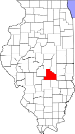
Shelby County, Illinois Basics:


Shelby County Illinois - Government Site

Population: 22,205
Area: 759 square miles
County seat: Shelbyville
Area code(s) in use: 217 618
Time zone: CST
High school graduate or higher: 88.9%
Bachelor's degree or higher: 14.8%
Median household income: $46,546
Persons in poverty: 10.1%
Home ownership rate: 81.4%
Mean travel time to work: 23.1 minutes


Adjacent counties:
Christian  Coles  Cumberland  Effingham  Fayette  Macon  Montgomery  Moultrie  
Find in Illinois

Map of the Shelby County area


Our detail map of Shelby County shows the Shelby County, Illinois boundary lines and other interesting items.

Places in Shelby County, Illinois

  Airports     show all on map

Enoch Airport, Hilvety Airport, Howell Airport, Moffet Landing Strip, Paul E. Kroenlein Airport, Shelby County Airport, Stoune RLA Airport, Williamson Airport, Wittenberg Airport

  Bays     show all on map

Buoy Cove, Club Cove, Coon Cove, Eagle Nest Cove, Lithia Springs Cove, Ninth Street Cove, Opossum Cove, Three Fingers Cove

  Bridges     show all on map

Copeland Bridge, Countyline Bridge, Cowden Bridge (historical), Moore Bridge, Shellen Barker Bridge (historical), Thompson Mill Covered Bridge

  Buildings     show all on map

Ash Grove Townhall, Clarksburg Townhall, Cold Spring Townhall, Cowden Fire Protection District, Findlay Fire Department and Ambulance Service, Herrick Fire Department, Moweaqua Community Ambulance Service, Moweaqua Community Fire Protection District, Rural Townhall, Shelby Area Ambulance Company, Shelby County Courthouse, Shelby Memorial Home, Shelbyville Fire Protection District, Shelbyville Free Public Library, Sigel Fire Protection District, Stewardson Fire and Ambulance Protection District, Strasburg Fire Protection District, Tower Hill Fire Protection District, Windsor Area Ambulance Service, Windsor Fire District

  Cemeteries     show all on map

Anderson Cemetery, Armstrong Cemetery, Armstrong Cemetery, Ash Grove Cemetery, Askins Cemetery, Austin Cemetery, Barker Cemetery, Bateman Cemetery, Bethany Cemetery, Bethany Cemetery, Bethel Cemetery, Bluff Cemetery, Bruce Cemetery, Brunswick Cemetery, Bryson Cemetery, Buchanan Cemetery, Caldwell Cemetery, Campbell Cemetery, Carpenter Cemetery, Center Cemetery, Chaffee Cemetery, Chisenhall Cemetery, Claridge Cemetery, Clark Cemetery, Cochran Cemetery, Combest Cemetery, Coons Cemetery, Copperas Cemetery, Corley Cemetery, County Home Cemetery, Craig Cemetery, Cutler Cemetery, Devore Cemetery, Downey Cemetery, Edwards Cemetery, Eiler Cemetery, Elbert Cemetery, Ellis Cemetery, Findlay Cemetery, Finley Cemetery, Firgason Cemetery, Fortner Cemetery, Foster Cemetery, Gallagher Chapel Cemetery, Gaskill Cemetery, Giles Cemetery, Glenwood Cemetery, Grace Cemetery, Graybill Cemetery, Harmon Cemetery, Harmon Cemetery, Helton Cemetery, Henderson Cemetery, Henton Cemetery, Hidden Cemetery, Hilligoss Cemetery, Hodson Cemetery, Horsman Cemetery, Howe Cemetery, Hubbartt Cemetery, Hudson Cemetery, Hudson Cemetery, Independent Order of Oddfellows Cemetery, James Rose Cemetery, Johnson Cemetery, Jordan Cemetery, Knobs Baptist Cemetery, Liston Cemetery, Little Flock Cemetery, Locust Grove Cemetery, Lower Ash Grove Cemetery, Ludwig Cemetery, Lutheran Cemetery, Mahoney Cemetery, Martin Cemetery, Masonic Cemetery, Mautz Cemetery, McCoy Cemetery, Methodist Cemetery, Middlesworth Cemetery, Middlesworth Cemetery, Moberley Cemetery, Moore Cemetery, Mound Cemetery, Mound Cemetery, Mound Cemetery, Mount Carmel Cemetery, Mount Cemetery, Mount Hermon Cemetery, Mount Olive Cemetery, Mount Pleasant Cemetery, Mount Zion Cemetery, Moyer Cemetery, Mud Run Cemetery, Myers Cemetery, Neal Cemetery, New Hope Cemetery, Oak Grove Cemetery, Oconee Mound Cemetery, Oliver Cemetery, Plank Cemetery, Pleasant Grove Cemetery, Pleasant Hill Cemetery, Point Lookout Cemetery, Prairie Home Cemetery, Prairie Union Cemetery, Price Cemetery, Quigley Cemetery, Raney Cemetery, Red Bank Cemetery, Reed Cemetery, Rhodes Cemetery, Richland Cemetery, Ridge Cemetery, Rincker Cemetery, Robinson Creek Cemetery, Rockford Cemetery, Rose Cemetery, Rosebud Cemetery, Sacred Heart Cemetery, Saint Johns Cemetery, Saint Michael Cemetery, Saint Patick's Cemetery, Saint Paul Cemetery, Saint Paul Cemetery, Saint Paul's Cemetery, Salem Cemetery, Sand Creek Cemetery, Shaw Cemetery, Shelby Cemetery, Smith Cemetery, Smith Cemetery, Soliday Cemetery, Spain Cemetery, Stewardson Cemetery, Sulphur Springs Cemetery, Swallow Cemetery, Swedish Cemetery, Templeton Cemetery, Tolley Cemetery, Tower Hill Cemetery, Traughber Cemetery, Union Cemetery, Union Cemetery, Vermillion Cemetery, Wade Cemetery, Walden Cemetery, Walker Cemetery, Wallis Cemetery, Warren Cemetery, Washington Cemetery, Watton Cemetery, Welborn Cemetery, Wendling Cemetery, Westside Cemetery, Whiteside Cemetery, Windsor Cemetery, Wolf Creek Cemetery

  Census     show all on map

Westervelt Census Designated Place

  Churches     show all on map

Ash Grove Church, Bethany Church (historical), Center Community Church, Church of Christ, Fame Evangelical Church, Fellowship Baptist Church, First Baptist Church, First Baptist Church, First Presbyterian Church, First United Methodist Church, First United Methodist Church, Fletcher Church (historical), Free Methodist Church, Gaskill Chapel, Grace Baptist Church, Grace Lutheran Church, Hopewell Baptist Church, Hubbartt Church (historical), Immaculate Conception Catholic Church, Jordan Chapel (historical), Knobs Baptist Church, Liberty Church (historical), Little Flock Church, Locust Grove Church, Lower Ash Grove Church, Moulton Methodist Church, Mount Carmel Church, Mount Hermon Church, Mount Pleasant Church, Neoga Church (historical), New Liberty Church, Oak Grove Church (historical), Okaw Center Church (historical), Pleasant Hill Church (historical), Richland Church (historical), Robinson Creek Church, Rockford Church (historical), Saint Francis De Sales Catholic Church, Saint Johns Church, Saint Marys Church, Saint Michael Catholic Church, Saint Patricks Church, Saint Pauls United Church of Christ, Sand Creek Church (historical), Sanner Chapel United Methodist Church, Seventh Day Adventist Church, Shelby Christian Church, Stewardson United Methodist Church, Strasburg United Methodist Church, Sulphur Springs Church (historical), Tower Hill Christian Church, Tower Hill United Methodist Church, Trinity Lutheran Church, Union Church (historical), Washington Church, Wesley Chapel, West New Hope Church, Windsor Christian Church, Windsor United Methodist Church, Zion Church, Zion Church (historical)

  Dams     show all on map

Bass Lake Dam, Boy Scout Lake Dam, Lake Mattoon Dam, Lake Shelbyville Dam, Langley Pond Dam, Pana Lake Dam

  Forests     show all on map

Hidden Springs State Forest

  Hospitals     show all on map

Shelby County Mental Health Center, Shelby Memorial Hospital

  Lakes     show all on map

Askins Lake

  Locales     show all on map

Johnstowne Mall Shopping Center, Possum Creek Campground, Prairie Home, Robinson Creek Station (historical), Shady Grove Campground, Shelby Country Club, Shelby County Poor Farm (historical), Town House

  Mines     show all on map

Brush Creek Quarry

  Parks     show all on map

Coon Creek Access Area, Eagle Creek State Park, Forest Park, Lithia Springs Access Area, Lone Point Access Area, Opossum Creek Access Area, Rocky Spring Access Area, Rolling Meadows Use Area, Shelby County Fairgrounds, Shelbyville Dam East Access Area, Shelbyville Dam West Access Area, Shelbyville Historic District, Spillway Access Area, Wolf Creek State Park

  Populated Places     show all on map

Clarksburg, Clarksburg, Cowden, Dollville, Duvall, Fancher, Findlay, Hanson, Henton, Herborn, Herrick, Kingman, Lakewood, Lithia, Middlesworth, Milne, Mode, Moweaqua, Obed, Oconee, Pleak, Rennerville, Sexson Corner, Shelbyville, Sigel, South Strasburg, Stewardson, Strasburg, Todds Point, Tower Hill, Trowbridge, Westervelt, Westminster (historical), Williamsburg (historical), Williamsburg Hill, Windsor, Yantisville

  Post Offices     show all on map

Big Spring Post Office (historical), Brush Creek Post Office (historical), Lakewood Post Office, Lithia Post Office (historical), Mode Post Office, Shelbyville Post Office, Westervelt Post Office

  Reservoirs     show all on map

Bass Lake, Boy Scout Lake, Hickory Ridge Pond, Lake Louise, Lake Shelbyville, Langley Pond, Pana Lake

  Ridges     show all on map

Bee Ridge, Corley Ridge

  Schools     show all on map

Ash Grove School (historical), Bee Ridge School (historical), Bethel School (historical), Black Log School (historical), Black Oak School (historical), Boiling Springs School (historical), Boone School (historical), Brunswick School (historical), Budward School (historical), Buell School (historical), Carrey School (historical), Center School (historical), Center School (historical), Center School (historical), Center School (historical), Center School (historical), Chadwick School (historical), Champion School (historical), Champion School (historical), Champion School (historical), Copperas School (historical), Corley School (historical), Cowden Elementary School, Cowden-Herrick High School, Cusaac School (historical), Dixie School (historical), Douglas School (historical), Dugout School (historical), East Liberty School (historical), East Salem School (historical), Empire School (historical), Eureka School (historical), Excelsior School (historical), Findlay Elementary School, Findlay High School, Flat Branch School (historical), Foster School (historical), Four Mile School (historical), Frogpond School (historical), Goodwill School (historical), Green Valley School (historical), Greenleaf School (historical), Grove School (historical), Hackberry School (historical), Harmon School (historical), Herrick Elementary School, Hiatt School (historical), Hickory School (historical), Holland School (historical), Independence School (historical), Independence School (historical), Killam School (historical), Knobs School (historical), Liberty School (historical), Little Brick School (historical), Lockwood School (historical), Locust Grove School (historical), Lodge School (historical), Long Grove School (historical), Mahoney School (historical), Main Street Elementary School, Maple Grove School (historical), Moonshine School (historical), Moulton Elementary School, Mound School (historical), Mount Pleasant School (historical), Mount Tabor School (historical), Mount Victory School (historical), Mount Victory School (historical), Moweaqua Elementary School, Moweaqua High School, Mud Run School (historical), New Harmony School (historical), North Liberty School (historical), Oakland School (historical), Palestine School (historical), Penn Consolidated School (historical), Pleasant Grove School (historical), Pleasant Union School (historical), Pleasant View School (historical), Prairie School (historical), Prairie Union School (historical), Ragweed School (historical), Redbud School (historical), Ridge School (historical), Robinson Creek School (historical), Rockford School (historical), Rocky Branch School (historical), Rose Center School (historical), Round Prairie School (historical), Saint Michael Catholic School, Sandy Hill School (historical), School Number 9 (historical), Section School (historical), Shelbyville High School, Smith School (historical), South Liberty School (historical), Standard School (historical), Stark School (historical), Stewardson-Strasburg High School, Summit School (historical), Swamp Angel School (historical), Sylvan School (historical), Sylvan School (historical), Tower Hill Elementary School, Tower Hill High School, Trinity Lutheran School, Turney School (historical), Union School (historical), Union School (historical), Victor School (historical), Victory School (historical), Vine Street School, Wabash School (historical), Wateroak School (historical), West Salem School (historical), White Oak School (historical), Whitlatch School (historical), Windsor Elementary School, Windsor High School, Wright School (historical)

  Streams     show all on map

Angel Branch, Bills Creek, Brush Creek, Brush Creek, Cary Branch, Coal Creek, Coon Creek, Copperas Creek, Drake Creek, Eagle Creek, Flat Branch, Green Creek, Henry Creek, Hog Creek, Howe Creek, Jordan Creek, Karnes Branch, Lake Fork, Lick Creek, Lithia Springs Creek, Little Creek, Matney Branch, Mud Creek, North Fork Shoal Creek, Opossum Creek, Opossum Creek, Opossum Creek, Polecat Creek, Rattlesnake Creek, Richland Creek, Robinson Creek, Rocky Branch, Sand Creek, Sexson Branch, Skull Creek, Sorghum Branch, Swafford Branch, West Branch Little Wabash River, Wilborn Creek, Wolf Creek

  Towers     show all on map

WEJT-FM (Shelbyville), WEJT-FM (Shelbyville), WSHY-AM (Shelbyville)

  Valleys     show all on map

McGillian Hollow,

Shelby County, Illinois Population By Race (2012 estimate)

RacePopulation
WhiteShelby County White population 21,89421,894  
MixedShelby County Mixed population 133133
AsianShelby County Asian population 6766
American IndianShelby County American Indian population 4444
Hawaiian & Pacific IslanderShelby County Hawaiian & Pacific Islander population 00

Additional population tables :
State population table
Illinois population by county