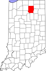
Kosciusko County, Indiana Basics:


Kosciusko County Indiana - Government Site

Population: 77,678
Area: 531 square miles
County seat: Warsaw
Area code(s) in use: 574 260
Time zone: EST
High school graduate or higher: 85.3%
Bachelor's degree or higher: 20.2%
Median household income: $50,822
Persons in poverty: 10.7%
Home ownership rate: 78.0%
Mean travel time to work: 20.5 minutes


Adjacent counties:
Elkhart  Fulton  Marshall  Miami  Noble  Wabash  Whitley  

Find in Indiana

Map of the Kosciusko County area


Our detail map of Kosciusko County shows the Kosciusko County, Indiana boundary lines and other interesting items.

Places in Kosciusko County, Indiana

  Airports     show all on map

Berkey Field Airport, H R Weisser Airport, Mentone Airport, Warsaw Municipal Airport, Wawasee Airport, Westrick Airport

  Bays     show all on map

Conklin Bay, Johnson Bay

  Buildings     show all on map

Atwood Fire Department, Atwood Volunteer Fire Department, Bowen Center, Burket Firemans Training Center, Burket Volunteer Fire Department, Claypool Volunteer Fire Department, Etna Township Fire Department, Four Way Ambulance Emergency Medical Service, Mentone Volunteer Fire Department, Milford Volunteer Fire Department, Multiple Township Emergency Medical Services, Multiple Township Emergency Medical Services - Milford, Multiple Township Emergency Medical Services - Warsaw, North Webster Tippecanoe Township Emergency Medical Services, North Webster Tippecanoe Township Fire Department, Otis R Bowen Center for Human Services Intake Center, Pierceton Fire Department, Plain Township Leesburg Volunteer Fire Department, Sidney - Jackson Township Volunteer Fire Department, Silver Lake Fire Department, Syracuse Fire Department Station 1, Syracuse Fire Department Station 2, Warsaw Fire Department Station 1, Warsaw Township Fire Department Station 2, Winona Lake Fire Department

  Canals     show all on map

Adams Ditch, Arm Number Two Ditch, Bierce Ditch, Biller Ditch, Boggs Ditch, Bollinger Ditch, Bryant Leininger Ditch, Coppes Ditch, Cretcher Ditch, Danner Ditch, Davisson Ditch, Dorsey Ditch, Easterday Ditch, Eaton Ditch, Fleugel Ditch, French Ditch, Fuller Arm, Funk Ditch, Graham Ditch, Graham Ditch, Hammond Ditch, Hatfield Arm, Heeter Ditch, Hepler Ditch, Hickman Ditch, Hoopingarner Ditch, Huffer Ditch, Keefer-Evans Ditch, Kinney Ditch, Kohler Ditch, Koontz Ditch, Kuhn Ditch, Kuhn Ditch, Lake Arm, Landis Ditch, Leedy Ditch, Lones Ditch, Long Ditch, Magee Ditch, Marsh Ditch, Marsh Ditch, Martin Ditch, McCarter Ditch, Meredith Ditch, Merrit Ditch, Meyer Ditch, Michaels Ditch, Miller Arm, Miller Ditch, Morrett Ditch, Omar Neff Ditch, Pole Run Ditch, Preston Miles Ditch, Puntney Ditch, Pyle Ditch, Rickle Ditch, Ring Ditch, Robbins Ditch, Robinson Ditch, Ruple Ditch, Sechrist Ditch, Sellers Ditch, Shanton Ditch, Silveus Ditch, Skinner Ditch, Sloan Ditch, Smith Ditch, Tennant Ditch, Truax Ditch, Tucker Ditch, Ulsch Ditch, Unrah Ditch, Westlake Ditch, White Ditch, Wilhelm-Kurtz Ditch, William Baker Ditch, Williamson Ditch, Wolf Arm, Wyland Ditch

  Capes     show all on map

Government Point

  Cemeteries     show all on map

Brumbaugh Cemetery, Byers Cemetery, Cable Cemetery, Circle Cemetery, Clemmers-Fishers Cemetery, Clunette Cemetery, Fairview Cemetery, Franklin Cemetery, Germantown Cemetery, Gospel Hill Cemetery, Graber Cemetery, Graceland Cemetery, Groves Cemetery, Hamman Cemetery, Highland Cemetery, Hillcrest Cemetery, Independent Order of Odd Fellows Cemetery, Island Cemetery, Lake Bethel Cemetery, Lakeside Cemetery, McClintic Cemetery, Milford Cemetery, Nichols Cemetery, Nye Cemetery, Oak Grove Cemetery, Oakwood Cemetery, Pleasant View Cemetery, Saint Francis Cemetery, Tamarack Cemetery, Union Cemetery, Union Cemetery, Weybright Cemetery

  Churches     show all on map

Billy Sunday Tabernacle, Camp Creek Church, Center Church, Church of the Little Flower, Concord Church, Cooks Chapel, Eel River Church, Eel River Church, Fellowship Church, Grove Chapel, Harrison Church, Hepton Union Church, Island Chapel, Lakeside Chapel, Millwood Chapel, Morris Chapel, Mount Pleasant Church, Mount Tabor Church, New Salem Church, North Winona Church, Old German Church, Olive Bethel Church, Palestine Church, Pierceton United Methodist Church, Pleasant Grove Church, Pleasant Valley Church, Pleasant View Church, Silver Creek Church, Stony Point Church, Walnut Creek Church, West Eel River Church, Zion Church

  Dams     show all on map

Palestine Lake Dam, Papakeechie Lake Dam, Webster Lake Dam-East, Weimer Black Dam

  Hospitals     show all on map

Kosciusko Community Hospital

  Islands     show all on map

Kale Island, Morrison Island, Ogden Island

  Lakes     show all on map

Allen Lake, Banning Lake, Barel-and-a-Half Lake, Beaver Dam Lake, Beigh Lake, Big Barbee Lake, Black Lake, Boner Lake, Caldwell Lake, Carr Lake, Center Lake, Crystal Lake, Dewart Lake, Diamond Lake, Durham Lake, Fish Lake, Goose Lake, Greider Lake, Grindle Lake, Hammond Lake, Heckman Lake, Heron Lake, Hill Lake, Hoffman Lake, Irish Lake, James Lake, Jamison Lake, Kiser Lake, Kuhn Lake, Lake Wawasee, Larrew Lake, Little Barbee Lake, Little Chapman Lake, Little Pike Lake, Long Lake, Loon Lake, McClures Lake, McPherson Lake, Morehead Lake, Mud Lake, Muskellunge Lake, North Little Lake, Pierceton Lake, Pike Lake, Pisgah Lake, Price Lake, Read Lake, Reed Lake, Ridinger Lake, Rothenbeger Lake, Sawmill Lake, Schultz Lake, Sechrist Lake, Sellers Lake, Sheely Lake, Sherburn Lake, Shock Lake, Shoe Lake, Sickle Lake, Silver Lake, Snoke Lake, South Little Lake, Spear Lake, Stafford Lake, Stanton Lake, Stevens Lake, Syracuse Lake, Tennant Lake, The Backwaters, Tibbitts Lake, Tippecanoe Lake, Waubee Lake, Webster Lake, Whyland Lake, Wyland Lake, Yellow Creek Lake

  Locales     show all on map

Corner View Farm, East Farms, Hill Top Duck Farm, Lemlar Farms, Lordan Farms, Maxwelton Golf Club, Miller Hog Farm, Sand Point, Slabaugh Farms, South Shore Golf Club, Tippecanoe Country Club, Wawasee Golf Club, Wawasee State Fish Hatchery

  Mines     show all on map

J and M Gravel Pit, Zimmerman Gravel Pit

  Parks     show all on map

Camp Alexander Mack, Camp Crosley, Camp Dick Runyan, Camp Tippecanoe, Chicago Boys Club Camp, Lakeview Park, Tri-County State Fish And Game Area

  Populated Places     show all on map

Arrowhead Park, Atwood, Barbee, Bayfield, Beaver Dam, Bell Rohr Park, Between-The-Lakes Park, Black Point, Burket, Buttermilk Point, Cedar Point, Claypool, Clunette, DeFries Landing, Eagle Point, Enchanted Hills, Epworth Forest, Etna Green, Forest Glen, Gravelton, Hastings, Highbanks, Highlands Park, Island Park, Kalorama Park, Kanata Manayunk, Kinsey, Lakeside Park, Lakeview Spring, Leesburg, Lowman Corner, Marineland Gardens, Mentone, Milford, Milford Junction, Mineral Springs, Monoquet, Musquabuck Park, North Webster, Oakwood Park, Osborn Landing, Oswego, Packerton, Palestine, Pickwick Park, Pierceton, Potawatomi Park, Quaker Haven Park, Redmon Park, Sevastopol, Shady Banks, Sidney, Silver Lake, Silver Point, South Park, Stoneburner Landing, Stony Ridge, Sunrise Beach, Syracuse, Vawter Park, Wa-Will-Away Park, Walker Park, Warsaw, Wawasee, Wawasee Village, Winona Lake, Wooster, Yellowbanks

  Post Offices     show all on map

Syracuse Post Office (historical), Wawasee Post Office (historical)

  Reservoirs     show all on map

Big Chapman Lake, Goldeneye Pond, Oswego Lake, Palestine Lake, Papakeechie Lake, Patona Bay

  Schools     show all on map

Atwood Elementary School, Burket Elementary School, Claypool Elementary School, Grace College and Seminary, Leesburg Elementary School, Madison Elementary School, Mentone Elementary School, Milford Elementary School, Milford Junior High School, North Webster Elementary School, North Webster Junior High School, Our Lady of the Lake Seminary, Pierceton Elementary School, Sidney Elementary School, Silver Lake Elementary School, South Whitley Elementary School, South Whitley Middle School, Syracuse Elementary School, Syracuse Junior High School, Warsaw Freshman High School, Warsaw High School, Warsaw Middle School, Wawasee High School, Whitko Middle School

  Streams     show all on map

Babcock Branch, Cable Run, Chippewanuck Creek, Crazy Creek, Eagle Creek, Grassy Creek, Little Yellow Creek, Plunge Creek, Trimble Creek, Walnut Creek, Walnut Creek, Yellow Creek

  Summits     show all on map

Dunham Hill, McElroy Hill

  Swamps     show all on map

Willets Lake

  Towers     show all on map

WBKE-FM (North Manchester), WBMP-FM (Elwood), WRSW-AM (Warsaw), WRSW-FM (Warsaw),

Kosciusko County, Indiana Population By Race (2012 estimate)

RacePopulation
WhiteKosciusko County White population 74,95974,959  
AsianKosciusko County Asian population 854854
MixedKosciusko County Mixed population 777776
BlackKosciusko County Black population 699699
American IndianKosciusko County American Indian population 311310
Hawaiian & Pacific IslanderKosciusko County Hawaiian & Pacific Islander population 00

Additional population tables :
State population table
Indiana population by county