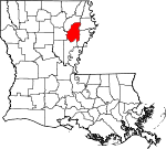
Franklin Parish, Louisiana Basics:
Franklin Parish Louisiana - Government Site
Population: 20,622
Area: 625 square miles
Parish seat: Winnsboro
Area code(s) in use: 318
Time zone: CST
High school graduate or higher: 68.5%
Bachelor's degree or higher: 11.9%
Median household income: $32,981
Persons in poverty: 28.3%
Home ownership rate: 71.8%
Mean travel time to work: 32.0 minutes
Adjacent counties:
Caldwell Catahoula Madison Richland Tensas
Places in Franklin Parish, Louisiana
Circle G Airport,
Collier Flying Service Landing Strip,
Fletcher Landing Strip,
Greg's Flying Service Airport,
Holcombs Flying Service Incorporated Airport,
Liddieville Airport,
Liddieville Airport,
Price Landing Strip,
Russell Airport,
Turkey Creek Lake Airport,
Winnsboro Municipal Airport,
Wisner-Gilbert Airport,
Yarbrough Brothers Airstrip Deer Creek Cutoff,
French Turn,
Turkey Creek Cut-Off Kendrick Ferry Bridge Baskin Volunteer Fire Department,
Crowville Volunteer Fire Department,
Franklin Parish Courthouse,
Franklin Parish Public Library,
Village of Gilbert Volunteer Fire Department,
Winnsboro City Hall,
Winnsboro Police Station,
Winnsboro Volunteer Fire Department,
Wisner Volunteer Fire Department Bayou Macon Cutoff Number One Block Cemetery,
Boeuf Prairie Cemetery,
Bonner Cemetery,
Buie Cemetery,
Carrway Cemetery,
Central Cemetery,
Chase Cemetery,
Coax Cemetery,
Crowville Cemetery,
Eureka Cemetery,
Fort Necessity Cemetery,
Friendship Cemetery,
Friendship Cemetery,
Harris Cemetery,
Henry Cemetery,
Hope Estate Cemetery,
Humble Cemetery,
King Cemetery,
Lone Cedar Cemetery,
Magnolia Cemetery,
Masonic Cemetery,
Myrtle Memorial Cemetery,
New Winnsboro Cemetery,
New Zion Cemetery,
Oak Grove Cemetery,
Oakley Cemetery,
Ogden Cemeteries,
Old Winnsboro Cemetery,
Pine Grove Cemetery,
Pleasant Hall Cemetery,
Providence Memorial Park Cemetery,
Reagan Cemetery,
Saint Paul Cemetery,
Shady Grove Cemetery,
Smith Cemetery,
State Place Cemetery,
Sunflower Cemetery,
True Light Cemetery,
Turner Cemetery,
Union Cemetery,
Ward Cemetery,
Wayside Cemetery,
Wiggers Cemetery,
Wooldrige Cemetery Bayou Lafourche Cutoff Apostolic Church of Jesus Christ,
Apostolic Tabernacle,
Assembly of God Church (historical),
Augusta Baptist Church,
Baskin Chapel,
Bayou Macon Baptist Church,
Bell Union Church,
Bellview Church,
Bethel Christian Center,
Bethel Church,
Boeuf Prairie Methodist Church,
Boeuf River Baptist Church,
Boles Chapel,
Central Church,
Chase Church,
Chase Church,
Church of Christ (historical),
Church of God (historical),
Coax Church,
Crocketts Point Baptist Church,
Crowville Methodist Church,
Cuba Baptist Church,
Eureka Baptist Church,
Faith Tabernacle,
First Baptist Church,
First Baptist Church of Crowville,
First Church of the Nazarene,
First United Methodist Church,
First Zion Baptist Church,
Fish Bayou Church,
Fort Necessity Baptist Church,
Freedom Bible Church,
French Turn Church,
Friendship Church,
Friendship Church,
Harmony Baptist Church,
Hill Ridge Church,
Jesus Name Church,
Jesus Name Home Mission Church,
Jigger Apostolic Church,
Jigger Church,
King Church,
Kingdom Hall,
Lamar Church,
Liddieville Free Methodist Church,
Locust Hill Baptist Church,
Lone Cedar Baptist Church,
Lone Pine Baptist Church,
Magnolia Church,
Mason Ridge Church,
Mixon Church,
Morning Pilgrim Church,
Mount Olive Church,
Mount Pleasant Church,
Mount Zion Church,
New Alpha and Omega Church,
New Hope Church,
New Light Church,
New Lillie Church,
New Zion Baptist Church,
North Central Church,
Oak Grove Baptist Church,
Oakley Church,
Old Macedonia Church,
Pentecostal Church,
Pine Prairie Church,
Pleasant Green Church,
Pleasant Hall Baptist Church,
Pleasant Star Church,
Pleasant Star Church,
Rosenwald Church,
Saint John Baptist Church,
Saint Luke Church,
Saint Mark Church,
Saint Marys Catholic Church,
Saint Patricks Church,
Saint Paul Church,
Saint Paul Church Number 2,
Saint Peter's Church,
Sardis Church,
Second Baptist Church,
Shady Grove Baptist Church,
Shiloh Baptist Church,
Sweet Home Church,
Taylor Bayou Church,
Temple Baptist Church,
True Light Baptist Church,
True Light Church,
Turkey Bluff Church,
Turkey Creek Baptist Church,
Union Church,
Union Church,
Union Grove Church,
Union Valley Church,
Union Valley Church,
Waverly Church,
Wayside Church,
Winnsboro Assembly of God Church,
Winnsboro Pentecostal Church Brannin Ferry (historical),
Egypt Ferry (historical) Louisiana Noname 92 Dam,
Turkey Creek Dam Boeuf Prairie Ash Slough,
Black Bayou,
Boggy Bayou,
Boggy Bayou,
Bulls Bayou,
Deep Bayou,
Frog Island Slough,
Gin Bayou,
Grayson Bayou,
Hurricane Slough,
Joe Bayou Boeuf River,
Long Bayou,
Luster Bayou,
Martin Slough,
Mill Bayou,
Mound Bayou,
Muddy Slough,
Oak Bluff Bayou,
Open Slough,
Prickett Bayou,
Sallers Bayou,
Shop Bayou,
Stokes Bayou,
Wolf Bayou Franklin Medical Center Cocklebur Island,
Eagle Island,
Rabbit Island Batese Lake,
Beeler Lake,
Bell Lake,
Big Cow Lake,
Board Tree Lake,
Butler Landing,
Calf Lake,
Clarks Bayou,
Dan Lake,
Dry Lake,
East Johnson Lake,
East Lake,
Fish Bayou,
Forest Lake,
Green Lake,
Guice Lake,
Harris Lake,
Hicktom Lake,
Hog Lake,
Hollywood Lake,
Horseshoe Lake,
Johnson Lake,
Lake Dean,
Little Cow Lake,
Little Lake,
Middle Lake,
Moon Lake,
Moon Lake,
Mullen Lake,
Plum Thicket Lake,
Redfield Lake,
Sayre Lake,
Sims Lake,
Tank Lake,
Twin Lakes,
Willis Lake Kendrick Ferry,
Kollen Landing,
Louisiana State University Research Center,
Macon Ridge Agricultural Experiment Station,
Twin Oaks County Club,
Winnsboro Industrial park Baskinton Oil Field,
Egypt Ferry Gas Field,
Lamar Oil,
Lamar Oil Field,
South Baskinton Oil Field,
South Big Creek Oil Field,
Southwest Delhi Oil Field,
True Light Church Gas Field,
West Baskinton Oil Field,
Wisner Oil Field Civitan Park,
Davis Park,
Jackson Street Historic District,
Landis Memorial Park,
Town Square Park,
West Winnsboro Recreational Park,
Wildcat Stadium,
Winnsboro Commercial Historic District Bakers,
Baskin,
Baskinton,
Big A Plenty Landing,
Big Creek,
Brownell,
Buie,
Bushes,
Chase,
Chelly Landing,
Como,
Craig Landing,
Crowville,
Cut Off Landing,
Dickey Landing,
Dixie Landing,
Elam,
Extension,
Fort Necessity,
Gilbert,
Griffin,
Harris Landing,
Holly Grove,
Jigger,
Jones Landing,
Lamar,
Liddieville,
Longview,
Lorelein,
Mason,
Metropolis,
Oakley,
Oakley Landing,
Oakwood Landing,
Stones Landing,
Sunrise Landing,
Swampers,
Talbot Landing,
Waller Landing,
Warsaw Landing,
Winnsboro,
Wisner Baskin Post Office, Baskinton Post Office (historical), Beouff Prairie Post Office (historical), Betty Post Office (historical),
Chase Post Office, Chase Post Office (historical), Como Post Office (historical), Crowville Post Office, Dover Post Office (historical), Dunham Post Office (historical), Elam Post Office (historical), Extension Post Office (historical),
Fort Necessity Post Office, Gilbert Post Office, Holly Grove Post Office (historical),
Jigger Post Office, Lamar Post Office (historical), Liddieville Post Office (historical), Louisville Post Office (historical), Mason Post Office (historical), Oakes Post Office (historical), Oakley Post Office (historical), Prairie Landing Post Office (historical), Swampers Post Office (historical),
Winnsboro Post Office, Wisner Post Office (historical)
Big Brake,
Turkey Creek Lake Hill Ridge Baskin School,
Bethel School,
Central High School,
Cordill School (historical),
Crowville School,
Cuba School,
Fort Necessity Junior High School,
Fort Necessity School,
Franklin Academy School,
Franklin Parish High School,
Gilbert Junior High School,
Horace G White Sr Learning Center School,
Jesus Name Christian School,
Louisiana Technical College Northeast Campus,
Ogden High School,
Pardue School,
Ward 3 High School (historical),
Waverly School,
Winnsboro Lower Elementary School,
Winnsboro Upper Elementary School,
Wisner Elementary School (historical),
Wisner High School (historical),
Wisner Junior High School Ash Slough,
Ash Slough,
Bayou Macon,
Bens Bayou,
Big a Plenty Bayou,
Big Bayou,
Big Creek,
Big Roaring Bayou,
Black Bayou,
Brushey Bayou,
Brushy Bayou,
Dean Bayou,
Deep Bayou,
Duck Creek,
Duck Creek,
Flowers Bayou,
Goose Creek,
Goose Creek,
Hurricane Bayou,
Johnson Bayou,
Lighting Bayou,
Little Brake,
Little Turkey Creek,
Loften Bayou,
Long Bayou,
Long Branch,
Lower Eagle Creek,
Muddy Bayou,
Otter Bayou,
Pine Bayou,
Pine Bayou,
Pine Creek,
Pine Creek,
Pricket Bayou,
Roaring Bayou,
Rowing Bayou,
Sandy Bayou,
Skinny Bayou,
Stillhouse Creek,
Turkey Bayou,
Turkey Creek,
Upper Eagle Creek,
Wards Bayou,
West Turkey Creek Bakers Brake,
Boggy Womble Brake,
Howell Brake,
Little Hog Glade,
Snyder Brake,
Wileys Brake KMAR-AM (Winnsboro),
KMAR-FM (Winnsboro),

