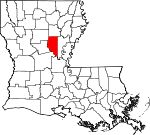
La Salle Parish, Louisiana Basics:
La Salle Parish Louisiana - Government Site
Population: 14,863
Area: 625 square miles
Parish seat: Jena
Area code(s) in use: 318
Time zone: CST
High school graduate or higher: 81.5%
Bachelor's degree or higher: 13.6%
Median household income: $43,641
Persons in poverty: 10.4%
Home ownership rate: 84.9%
Mean travel time to work: 37.1 minutes
Adjacent counties:
Avoyelles Caldwell Catahoula Grant Rapides Winn
Places in La Salle Parish, Louisiana
Hardtner Medical Center Heliport,
Jena Airport,
Olla Airport Big Bay,
Kitterlin Bay Big Bend,
Big Bend,
Boggy Bend,
Fool River Bend,
Mosquito Bend Eden Fellowship Volunteer Fire Department Station 1,
Eden Fellowship Volunteer Fire Department Station 2,
Jena Volunteer Fire Department,
Little Creek - Searcy Volunteer Fire Department,
Olla Volunteer Fire Department Station 1,
Olla Volunteer Fire Department Station 2,
Rogers Nebo Volunteer Fire Department,
Rogers Nebo Volunteer Fire Department Station 2,
Summerville - Rosefield Volunteer Fire Department,
Tullos Volunteer Fire Department,
Urania Volunteer Fire Department,
White Hall Volunteer Fire Department Catahoula Lake Diversion Canal Big Point,
Big Point,
Bird Island Point,
Powell Point,
River Point,
Routh Point,
Saline Point Antioch Cemetery,
Belah Cemetery,
Blake Cemetery,
Chalk Hill Cemetery,
Chevallier Cemetery,
Coon Cemetery,
Dayton Cemetery,
Dempsey Cemetery,
Doughty Cemetery,
Eden Cemetery,
Forsyth Cemetery,
Frazier Cemetery,
Hailey Cemetery,
Hair Cemetery,
Harris Chapel Cemetery,
Hawthorne Cemetery,
Hurricane Cemetery,
Jackson Cemetery,
Jena Cemetery,
Kees Cemetery,
Little Chickasaw Cemetery,
Magnolia Cemetery,
McBroom Cemetery,
McCure Cemetery,
Miller Cemetery,
Moseley Cemetery,
Mount Sinai Cemetery,
Mount Zion Cemetery,
Nebo Cemetery,
New Union Cemetery,
Nolley Cemetery,
Norris Cemetery,
Oak Grove Cemetery,
Olla Cemetery,
Pendarvis Cemetery,
Penecost Cemetery,
Pinehill Cemetery,
Pleasant Hill Cemetery,
Pritchard Cemetery,
Randall Cemetery,
Renfrow Cemetery,
Spencer Cemetery,
Squires Cemetery,
Summerville Cemetery,
Taylor Chapel Cemetery,
Thomas Cemetery,
Thompson Cemetery,
Tidwell Cemetery,
Turnley Cemetery,
Urania Cemetery,
Webster Cemetery,
Whatley Cemetery,
Whatley Cemetery,
Wilbanks Cemetery Midway Census Designated Place Aimoch Baptist Church,
Antioch Free Methodist Church,
Belah Church,
Belah United Methodist Church,
Bellevue Baptist Church,
Blade Church,
Chickasaw Free Methodist Church,
Crossroads Baptist Church,
Ebenezer Baptist Church,
Eden United Methodist Church,
Fellowship Baptist Church,
Gilmore Church (historical),
Harris Chapel (historical),
Hurricane Creek Baptist Church,
Little Brushley Church (historical),
Magnolia Baptist Church,
Mars Hill Baptist Church,
McVey Church,
Mount Sinai Baptist Church,
Mount Zion Church (historical),
Nebo Baptist Church,
New Union Missionary Baptist Church,
Nolley Memorial United Methodist Church,
Oak Ridge Baptist Church,
Pine Grove Baptist Church,
Pinehill Baptist Church,
Pleasant Hill Baptist Church,
Pleasant Ridge Baptist Church,
Pritchard Church,
Prosperity Baptist Church,
Searcy Baptist Church,
Shady Grove Church,
Standard Baptist Church,
Summerville Baptist Church,
Summerville Methodist Church (historical),
Taylor Chapel (historical),
Trout Church,
United Church,
Wayside Church,
Zenoria Baptist Church Doughty Bluff,
Indian Bluff Campbells Ferry (historical),
Rambeaus Ferry (historical),
Rhineharts Ferry (historical),
Thompsons Ferry (historical) Searcy Lake Dam Bushyhead Bayou,
French Fork,
Mound Bayou,
Nolan Bayou Hardtner Medical Center,
LaSalle General Hospital Rabbit Island Catahoula Lake,
Fool River,
Horseshoe Lake,
Hub Lake,
Lehman Lake,
Little Lake,
Little Lake Slough,
Moon Lake,
Round Lake,
Saline Lake,
Walker Lake,
Willow Lake,
Woodward Lake Camp Attakapas,
Pendarvis Landing,
Thompson Ferry,
Walkers Ferry Catahoula Lake Oil Field,
Chickasaw Creek Gas Field,
Cypress Bayou Oil Field,
East Muddy Bayou Oil Field,
East Nebo Oil Field,
French Fork Oil Field,
French Fork Oil Field,
Indian Bayou Oil Field,
Jena Airport Oil Field,
Little Bayou Oil Field,
Little Creek Oil Field,
Long Slough Oil Field,
Mosquito Bend Oil Field,
Muddy Bayou Oil Field,
Nebo-Hemphill Oil Field,
Nolans Bayou Oil Field,
North Big Island Oil Field,
North Saline Lake Oil Field,
North Searcy Gas Field,
Olla Oil Field,
Rabbit Branch Gas Field,
Rogers Oil Field,
Sandy Bayou Oil Field,
Searcy Oil Field,
South Catahoula Lake Oil Field,
South Frence Fork Oil Field,
Standard Gas Field,
Summerville Oil Field,
Trout Creek Oil Field,
Tullos Urania Oil Field,
West Catahoula Lake Oil Field,
West Elm Ridge Oil Field,
West Long Slough Oil Field,
West Saline Lake Oil Field,
West Searcy Oil Field Dewey W Wills State Wildlife Management Area,
Jena Town Park Belah,
Blade,
Cane,
Chickasaw,
Davis (historical),
Eden,
Fellowship,
Ganeyville,
Good Pine,
Hester,
Jena,
Little Creek,
Magnolia,
Midway,
Nebo,
Nickel,
Olla,
Rhinehart,
Rogers,
Routon,
Searcy,
Sharp Town,
Standard,
Summerville,
Trout,
Tullos,
Urania,
Webb Quarters,
White Sulphur Springs,
Whitehall,
Zenoria Blade Post Office (historical), Chickasaw Post Office (historical), Cruse Post Office (historical), Davis Post Office (historical), Eden Post Office (historical), Good Pine Post Office (historical), High Point Post Office (historical), Jena Post Office, Little Creek Post Office (historical), Nebo Post Office (historical), Nickel Post Office (historical), Olla Post Office,
Rhinehart Post Office, Rogers Post Office (historical), Routon Post Office (historical), Standard Post Office (historical), Summerville Post Office (historical),
Trout Post Office,
Tullos Post Office,
Urania Post Office, White Sulphur Springs Post Office (historical), Zenoria Post Office (historical)
Mill Pond Aimoch School (historical),
Antioch School (historical),
Belah School (historical),
Beulah School (historical),
Big Bend School (historical), Black Jack School (historical),
Center School (historical),
Crossroads School (historical),
Dawes Branch School (historical),
Ebenezer School (historical),
Evergreen School (historical),
Fellowship Elementary School,
Goodpine Middle School,
Gray School (historical),
Jena Elementary School,
Jena High School,
Jena Junior High School,
Jena Seminary (historical),
LaSalle High School,
LaSalle Junior High School,
Liberty School (historical),
Little Chickasaw School (historical),
Magnolia School (historical),
Nebo Elementary School,
Olla Standard Elementary School,
Olla-Standard High School (historical),
Pine Grove School (historical),
Pleasant Hill School (historical),
Prosperity School (historical),
Rosefield School (historical),
Searcy School (historical),
Standard School (historical), Summerville School (historical),
Tarvers School (historical),
Thayer School (historical),
Trout-Goodpine Kindergarten,
Tullos Elementary School (historical),
Tullos School (historical),
Urania Elementary School,
Urania High School (historical) Aimwell Spring,
White Sulphur Spring Adams Creek,
Alligator Bayou,
Alligator Branch,
Bacon Run,
Bayou Funny Louis,
Bear Branch,
Bear Branch,
Big Branch,
Big Bushley Creek,
Black Branch,
Browns Branch,
Buck Creek,
Buck Holly Branch,
Bull Bayou,
Camp Bayou,
Castor Creek,
Chickasaw Creek,
Clear Branch,
Clear Fork,
Clear Prong,
Cochran Creek,
Constantine Branch,
Cow Creek,
Cowpen Bayou,
Delaney Branch,
Devils Creek,
Doyle Branch,
Drake Creek,
Duck Slough,
Earl Creek,
Evans Branch,
Ezell Branch,
Fish Creek,
Franklin Branch,
Gelvin Creek,
Gotch Branch,
Hair Creek,
Hemphill Creek,
Hickory Branch,
Hodges Branch,
Horsepen Creek,
Hurricane Creek,
Indian Bayou,
Indian Creek,
Island Bayou,
Jones Branch,
Jones Creek,
Jumping Bayou,
Jumping Gully Creek,
Kitchen Creek,
Kitterlin Creek,
Lacroix Creek,
Lick Branch Hurricane Creek,
Lincecum Bayou,
Little Chickasaw Creek,
Little Cow Creek,
Little Creek,
Little Creek,
Little Creek,
Little Jordan Branch,
Little Saline Bayou,
Long Branch,
Long Slough,
Mack Branch,
Mason Branch,
Mill Creek,
Mill Creek,
Mill Creek,
Muddy Bayou,
Muddy Prong,
Muddy Slough,
Neal Branch,
New Union Creek,
North Fork Big Saline Bayou,
Palmetto Creek,
Pound Branch,
Rabbit Branch,
Riley Branch,
Rocky Creek,
Routh Creek,
Safety Creek,
Salty Creek,
Sandy Bayou,
Sandy Creek,
Sandy Creek,
Sandy Run,
Schoolhouse Branch,
Sulphur Creek,
Tar Kiln Branch,
Tarver Creek,
Taylor Bayou,
Thompson Branch,
Trout Creek,
Waterhole Branch,
West Prong Hemphill Creek,
Whiskey Run,
Zimmer Creek Bald Hill,
Mountain Hill Alligator Brake,
Campright Brake Bay Spring Lookout Tower,
Bay Springs Lookout Tower,
Belah Lookout Tower,
KJNA-AM (Jena),
KJNA-FM (Jena),
KQID-FM (Alexandria) Carr Hollow,
Mayhew Hollow,
Sandy Hollow,

